+Ernmark Posted May 5, 2008 Posted May 5, 2008 As many of the readers of this forum know, holograph maintains an excellent website - www.holoscenes.com which documents a tally of GEOCAC adventures, as well as some excellent maps. Another part of the site - visit link references the U.S. State Center of Population monuments, all of which were set after the 2000 Census. I have had occasion to visit 2 of them so far, and since most (if not all) were set too late to make it into the GC database (some not even in the NGS database), my challenge is this: If you have visited any of these monuments, please list the pictures to provide a gallery/tally of what's out there so far! I'll start w/ the 2 I've collected so far: Quote
AZcachemeister Posted May 5, 2008 Posted May 5, 2008 I have visited the Arizona version (there is/was a cache based on it), so I can fill in the AZ square! Sounds like a good excuse for kilted benchmarking! Quote
Wintertime Posted May 6, 2008 Posted May 6, 2008 In case you aren't aware, there are currently a couple of articles about the national and state CoP markers in Berntsen's Caching Now magazine, with a request for people to send in their photos of people visiting the markers. Patty Quote
NGS Surveyor Posted May 7, 2008 Posted May 7, 2008 Here is the link to the 200th Anniversary article on commemorative marks which includes the year 2000 Center of Population mark: http://celebrating200years.noaa.gov/survey...ks/welcome.html . Also see the NGS www page on State Centers of Population at: http://www.ngs.noaa.gov/INFO/COP/ . GeorgeL NGS Quote
foxtrot_xray Posted May 7, 2008 Posted May 7, 2008 Hmm.. I want to go get Georgia's.. maybe soon. Quote
CacheNCarryMA Posted May 7, 2008 Posted May 7, 2008 I placed a cache (two-stage multi beginning near the marker) near Massachusetts' population center -- "Center of Mass (GCNAT6)" See the cache page for links to other articles about population centers. Quote
ArtMan Posted May 8, 2008 Posted May 8, 2008 (edited) I visited the New Jersey Center of Population monument several years ago. It is just off the N.J. Turnpike a few miles south of New Brunswick in the borough of Milltown and located on the grounds of a municipal building. NEW JERSEY POPULATION CENTER (DE6224) was monumented in December 2001 and there are several recovery reports since then. (I didn't file one, presumably because it had been less than a year since the last report had been filed.) Unfortunately my photos were archived and unavailable at the moment. I have also seen the Maryland COP monument located in Laurel. -ArtMan- Edited May 8, 2008 by ArtMan Quote
+GEO*Trailblazer 1 Posted May 8, 2008 Posted May 8, 2008 I set that mark. What a nice little town. Yes I know and it was the main reason I went by to see and log it. You are a great mentor Mr. DaveD. The first recorded modern usage of the term can be traced to a book entitled "Les Aventures de Telemaque", by the French writer François Fénelon. In the book the lead character is that of Mentor. This book was published in 1699 and was very popular during the 18th century and the modern application of the term can be traced to this publication. This is the source of the modern use of the word mentor: a trusted friend, counselor or teacher, usually a more experienced person. Some professions have "mentoring programs" in which newcomers are paired with more experienced people in order to obtain good examples and advice as they advance, and schools sometimes have mentoring programs for new students or students who are having difficulties. Quote
+BilboB Posted May 9, 2008 Posted May 9, 2008 I have a cache at the Vermont Population center. It is an offset that includes finding the mark. I dont have a picture handy, but I know it surprises a lot of cachers when they stumble upon it. It's in a very inconspicuous place in a farmer's field in Warren, VT. Quote
CoyoteTrust Posted May 12, 2008 Posted May 12, 2008 I'm hoping to nab the Illinois one here soon. It should be around the small farm town of Mazon, IL. Will update you folks if I nab it. Quote
+Black Dog Trackers Posted May 12, 2008 Posted May 12, 2008 In the US Benchmarks Waymarking category there are logs for these markers for only 9 states: Maryland, New Mexico, Delaware, Pennsylvania, Colorado, Massachusetts, Virginia, Tennessee, and Arizona. Quote
+Maingray Posted May 13, 2008 Posted May 13, 2008 Picture from a log at NC's center...in a town called "Erect". Nearby cache: GCQPGM DI0243 HT_MOD - This is a Height Modernization Survey Station. DI0243 DESIGNATION - CENTER OF POPULATION DI0243 PID - DI0243 DI0243 STATE/COUNTY- NC/RANDOLPH DI0243 USGS QUAD - ERECT (1994) Quote
+Klemmer Posted May 13, 2008 Posted May 13, 2008 I'm sorry, I just have to ask: How would someone from Erect refer to themselves? I just wrote down five ways, and couldn't (didn't want to) post any here. Being from Placentia CA is confusing enough. Yes, it is Placentian. Quote
+GEO*Trailblazer 1 Posted May 13, 2008 Posted May 13, 2008 (edited) ERECT No need for Viagra there. They seem to have both horizontal and vertical control. Edited May 13, 2008 by GEO*Trailblazer 1 Quote
+GrizzFlyer Posted May 14, 2008 Posted May 14, 2008 Recovered Ohio yesterday. More pics at Ohio COP album Quote
+Firefighter Skippy Posted May 15, 2008 Posted May 15, 2008 This is Ct's. It's located in Cheshire, between 2 ballfields. Quote
+2/3 Marine Posted May 19, 2008 Posted May 19, 2008 Found the Colorado Center of Population monument today. I reported it to the NGS as it does have it's own PID# DH0707 Designation..SAMPSON MTN I noticed in an earlier post that this one in Colorado had been Waymarked. I was under the impression if a mark was in the database that it couldn't be Waymarked. Doesn't matter to me, just a question. Do the other ones around the country have PID#'s? Quote
+GEO*Trailblazer 1 Posted May 19, 2008 Posted May 19, 2008 Quite a few of them do have PID's. I have a KML of several of them I have been working on and updating as well. They will accept any US Benchmark at Waymarking. Quote
holograph Posted May 19, 2008 Posted May 19, 2008 Found the Colorado Center of Population monument today. I reported it to the NGS as it does have it's own PID# DH0707 Designation..SAMPSON MTN I noticed in an earlier post that this one in Colorado had been Waymarked. I was under the impression if a mark was in the database that it couldn't be Waymarked. Doesn't matter to me, just a question. Do the other ones around the country have PID#'s? The Geocaching database doesn't contain the PID, so there is no way to log it on GC.com other than through Waymarking. BTW, the PID is DH7070, not DH0707. Quote
+Ernmark Posted June 11, 2008 Author Posted June 11, 2008 Delaware WM1AAG - waymarked by whereabouts Quote
+Okiebryan Posted June 15, 2008 Posted June 15, 2008 I have a cache at Oklahoma's mean population center, but no one has ever set a marker. It fell on an old abandoned railroad bed (no tracks), about 100 feet from a State Highway ROW. Quote
+LegendOfZelda Posted June 21, 2008 Posted June 21, 2008 (edited) I have the TX marker (3 pics) from Holland, TX. I still dont understand how others post a large static image in the thread. And my imageshack pix is so small and/or I can't upload the picture from my PC. I clearly need to spend a few minutes learning the tools better. Edited June 22, 2008 by LegendOfZelda Quote
+Harry Dolphin Posted June 21, 2008 Posted June 21, 2008 Either log and upload them into the Waymarking Category, or upload them somewhere else, such as Flikr, or one of your archived caches. I put lots of strange pictures on one of my missing geocoins. Which is where I'll put the Center of Populaton disk photo, if and when I find it. Then use the url from that site. Quote
+Harry Dolphin Posted July 17, 2008 Posted July 17, 2008 My work in Sullivan County, New York is done! After the next update, I should have turned Sulliovan County red (on holographs' maps)! Next project is Monroe County, Pa. In the meantime, the New York Center of Population marker is a short distance north of Port Gerbil. I should get that this weekend. I'm not a fan of WhyBotherMarking.com, so I'll upload the photo to one of my dead geocoins (and log it with NGS). And post the photo here. You all may wait with baited breath. Quote
andylphoto Posted July 17, 2008 Posted July 17, 2008 I have the TX marker (3 pics) from Holland, TX. I still dont understand how others post a large static image in the thread. And my imageshack pix is so small and/or I can't upload the picture from my PC. I clearly need to spend a few minutes learning the tools better. What you need to do is get the URL of the large image shack photo, then enclose that URL in [ IMG ] [ /IMG ] tags, eliminating the spaces. The result is this: Quote
+Harry Dolphin Posted July 19, 2008 Posted July 19, 2008 DG9708 2000 New York State Center of Population Close up of disk View Northwest toward Center of Population Monument Boy! These things are large! Okay. Who told on me?!? I was cleaning off the disk, when a gentleman approached. He was driving through the parking lot when he espied us, and wondered what we were doing. He was part of the crew that set the disk. We had a discussion. The disk is a few miles off from the actual center, but NGS wanted a public spot, with GPS coveraage, so the Delaware and Hudson Canal Park was selected. He was delighted to see someone actually looking for the disk, and had never heard of using cornstarch to bring out the markings. We were joined by a park employee, who promised to replant the flower bed, and take better care of the monument. I also entered it on Whymarking. That was tougher than setting up a cache! I doubt that I would ever go back to that location! What a pain! But, I did it as a courtesy. Oh, well. Quote
+chiknlips45 Posted July 29, 2008 Posted July 29, 2008 I visited the Alaska Center of Population Disk on Sunday. Coordinates I had were N 61° 34.693, W 149° 08.331 with 7 Ft of variation. Quote
CoyoteTrust Posted August 7, 2008 Posted August 7, 2008 (edited) Looks like Illinois has a sewer grate for its monument! I finally got down to the area of the mark and was excited to look for it. I found this witness post but nothing else. Kicked around some dirt and crushed limestone from the walking path, but no dice. So I circled the park twice, and cannot figure out where the mark is -- if it's even monumented yet. The holoscenes web states: "This station was dedicated July 10, 2004 but has not yet been accepted into the NGS database. It is located at the edge of Centennial Park in Mazon, Illinois." I went to the village hall (closed at 12:30) and later talked to 3 locals who did not know about the mark. One person, after I told him I went to the village hall, told me "yeah it's closed the lady across the street works there and she just came home. You might ask her husband -- he's the police officer here -- but I think he's out of town." Heh heh heh -- I always did like small towns and the people therein. My quest is to be continued, I hope. Edited August 7, 2008 by CoyoteTrust Quote
+Shorelander Posted August 8, 2008 Posted August 8, 2008 Heh, I wonder how far out to sea Hawaii's would be. Quote
68-eldo Posted August 8, 2008 Posted August 8, 2008 (edited) Heh, I wonder how far out to sea Hawaii's would be. It’s about 13.8 miles SW of Makapuu Light house and 14.2 miles WNW of the southwest point of Molokai. Coordinates are here 21 8 48.36 N 157 31 28.03 W I took a guess and was off by about 14.5 miles. Edited August 8, 2008 by 68-eldo Quote
+Shorelander Posted August 8, 2008 Posted August 8, 2008 Heh, I wonder how far out to sea Hawaii's would be. It’s about 13.8 miles SW of Makapuu Light house and 14.2 miles WNW of the southwest point of Molokai. Coordinates are here 21 8 48.36 N 157 31 28.03 W I took a guess and was off by about 14.5 miles. Oops, I should read the original link's information first. My bad. I wonder how much effort it would take to get a buoy out there... Quote
+89SC Posted August 24, 2008 Posted August 24, 2008 I found West Virginia's disk. The coordinates had me within 4 feet. Looking toward exit 67 of I-79 at Flatwoods: N 38° 42.073 W 080° 39.765 Quote
foxtrot_xray Posted August 24, 2008 Posted August 24, 2008 Looks like Illinois has a sewer grate for its monument! Having lived in Illinois, I think you're right. And wouldn't be surprised. I think I'll be making a trip down to my state's marker after my trip out west. It's tempting. Quote
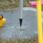
AZcachemeister Posted August 24, 2008 Posted August 24, 2008 I thought it was high time for me to get mine posted, so I headed over there this morning. A close-up of the mark with the GPSr. GPS (HH2) co-ordinates N33º 21.367' W111º 48.990'. A close-up of the mark alone. The nearby sign. A wide view at the co-ordinates given at the sign, looking west. The actual spot appears to be a few feet inside this back yard. Quote
+GEO*Trailblazer 1 Posted September 4, 2008 Posted September 4, 2008 I finally got the NM Population Center. It was late when we finally got there, raining and thunderstorms so the images are not that good but I got em anyway. Had a great adventure getting there as well. Quote
+m&h Posted September 6, 2008 Posted September 6, 2008 We went out to Kanaskat-Palmer State Park in King County, Washington, to see the Population Center monument put there in 2002. Here's a close-up of the 8-inch disk: And here's the "eye-level" of the boulder from about eight feet away. The plaque does not refer to the mark. And this is an area shot, showing on the left the picnic pavilion and on the right the restrooms, both of which are used as reference points in the data sheet description (not in a box score): There's a King County disk not far from the boulder. It's a reference mark, and the number on it has been obliterated, apparently professionally. We'll look further into that. Quote
+escondido100 Posted September 7, 2008 Posted September 7, 2008 aloha...this topic caught my eye and i did a little research...thinking i would either find our marker or make a cache with this as a theme...turnd out that hawaii's COP is in the water.....not just a little bit...but a lot....so is this the only state that wont have a marker?...fortunately i found the info for the counties as well and may pursue locating those COPs or maybe make a cache series....interesting...any input??? Quote
+Ernmark Posted September 7, 2008 Author Posted September 7, 2008 aloha...this topic caught my eye and i did a little research...thinking i would either find our marker or make a cache with this as a theme...turnd out that hawaii's COP is in the water.....not just a little bit...but a lot....so is this the only state that wont have a marker?...fortunately i found the info for the counties as well and may pursue locating those COPs or maybe make a cache series....interesting...any input??? ..alas, there are other states which haven't set markers - Holograph's website is a great resource for 'extreme' benchmak info! Quote
AZcachemeister Posted September 29, 2008 Posted September 29, 2008 This last Sunday, the Arizona COP mark was occupied to get it into the database! The results of the four hour occupation are: NAD83 lat\lon N 33 21.3641 W 111 48.9886 WGS84 lat\lon N 33 21.3643 W 111.48.9894 OPUS solution : 23642720.obs 000439520 FILE: 23642720.obs 000439520 2005 NOTE: The IGS precise and IGS rapid orbits were not available 2005 at processing time. The IGS ultra-rapid orbit was/will be used to 2005 process the data. 2005 NGS OPUS SOLUTION REPORT ======================== All computed coordinate accuracies are listed as peak-to-peak values. For additional information: www.ngs.noaa.gov/OPUS/Using_OPUS.html#accuracy USER: brian.fisher AT surpriseaz.com DATE: September 29, 2008 RINEX FILE: 2364272l.08o TIME: 13:38:24 UTC SOFTWARE: page5 0612.06 master30.pl START: 2008/09/28 11:00:00 EPHEMERIS: igu14990.eph [ultra-rapid] STOP: 2008/09/28 17:06:30 NAV FILE: brdc2720.08n OBS USED: 15121 / 17340 : 87% ANT NAME: TRM_R8_GNSS NONE # FIXED AMB: 104 / 114 : 91% ARP HEIGHT: 2.2 OVERALL RMS: 0.018(m) REF FRAME: NAD_83(CORS96)(EPOCH:2002.0000) ITRF00 (EPOCH:2008.7421) X: -1981984.041(m) 0.004(m) -1981984.765(m) 0.004(m) Y: -4951183.862(m) 0.013(m) -4951182.510(m) 0.013(m) Z: 3487199.246(m) 0.011(m) 3487199.135(m) 0.011(m) LAT: 33 21 21.84591 0.003(m) 33 21 21.86050 0.003(m) E LON: 248 11 0.68431 0.007(m) 248 11 0.63888 0.007(m) W LON: 111 48 59.31569 0.007(m) 111 48 59.36112 0.007(m) EL HGT: 341.861(m) 0.015(m) 340.976(m) 0.015(m) ORTHO HGT: 371.692(m) 0.044(m) [NAVD88 (Computed using GEOID03)] UTM COORDINATES STATE PLANE COORDINATES UTM (Zone 12) SPC (0202 AZ C) Northing (Y) [meters] 3691059.458 261242.768 Easting (X) [meters] 424034.972 222684.365 Convergence [degrees] -0.44895336 0.05508860 Point Scale 0.99967115 0.99990107 Combined Factor 0.99961750 0.99984741 US NATIONAL GRID DESIGNATOR: 12SVB2403591059(NAD 83) BASE STATIONS USED PID DESIGNATION LATITUDE LONGITUDE DISTANCE(m) AJ6820 SRP1 SALT RIVER PROJEC CORS ARP N332702.248 W1121339.999 39674.7 DG6513 AZSC CNTR FOR ARTS CORS ARP N332930.462 W1115521.447 18003.1 AH3759 COSA SCOTTSDALE CORS ARP N333407.379 W1115255.734 24364.2 NEAREST NGS PUBLISHED CONTROL POINT DU0764 RV 268 N332147. W1114823. 1218.5 This position and the above vector components were computed without any knowledge by the National Geodetic Survey regarding the equipment or field operating procedures used. Quote
tosborn Posted September 30, 2008 Posted September 30, 2008 Don't you have to observe on two consecutive days 4 hours apart? Quote
AZcachemeister Posted September 30, 2008 Posted September 30, 2008 (edited) Not if you wait for four or more years after the monument was installed! Actually, I was there to discuss the upcoming GEOCAC BM for Arizona, the NSPS Geocache project, and ESRI GIS day. Getting a photo of the monument being occupied was a bonus. Mr. Fisher (Party Chief) stated he needed to return with an extension, as there is a tree blocking to the northeast. P.S. I received a PM from DaveD to tell me that one only needs a single observation session if the data is submitted via OPUS-DB. EDITED: To add P.S. Edited October 1, 2008 by AZcachemeister Quote
CoyoteTrust Posted October 14, 2009 Posted October 14, 2009 A tenacious cacher placed a geocache near the State of Illinois Center of Population mark (GC1Z7TN). He was lucky enough to find people who KNEW about the mark while I had some trouble on my previous visits (refer to my earlier post in this thread). Now, the witness post is gone, and some of the greenery and crushed limestone (a park recreational path) have been moved to make the mark visible. Quote
+Growf Posted October 17, 2009 Posted October 17, 2009 I visited the Alaska Center of Population Disk on Sunday. Coordinates I had were N 61° 34.693, W 149° 08.331 with 7 Ft of variation.[Just saw this thread since someone posted re: the IL mark] Having been to Alaska, my first reaction was surprise when I saw that the mark was in an apparently populated area -- but then I remembered that -- Oh Yeah! -- Everybody pretty much lives in Anchorage ;-) (OK, not exactly -- ~40% of Alaska's population is in the Anchorage area, so I'm sure that heavily weights the centering to be in that area) Quote
+Growf Posted October 17, 2009 Posted October 17, 2009 (edited) This last Sunday, the Arizona COP mark was occupied to get it into the database!Kinda cool that the mark (or rather the monument that the mark itself is set in) is visible via Google Maps. Also looks like Google Maps may be more tuned to the NAD83 data than the WGS84 Edited October 17, 2009 by Growf Quote

Recommended Posts
Join the conversation
You can post now and register later. If you have an account, sign in now to post with your account.
Note: Your post will require moderator approval before it will be visible.