


PinkDolphin
-
Posts
70 -
Joined
-
Last visited
Posts posted by PinkDolphin
-
-
I uploaded mine last night. The find count is now correct, but for some reason I now have a find in Ohio.
 (I have never cached in Ohio.) It's one I found back on '06, and no, it's not a traveling cache.
Me too, sort of. I did an upload earlier today and I have 3 caches in New Hampshire, I have never even been to New Hampshire let alone cached there. All 3 of those were caches found last Labor Day Weekend in Virginia. I also have a cache in Washington State, which is a cache I found here in NC and is still in NC.
Not too concerned, but just thought I would throw that out, I am sure it will get sorted out.
PinkD
-
An arrangement to bring INATN back to life has been... arranged. More details to follow...
Edit: ...and I am continuing with my intention from the start of not making it a "for-pay" site.
 The only fee to you will continue to be that you need to be a Premium Member at GC.com because you need to be able to download the PQ that INATN needs.
I am very happy to hear that. I love your site!
-
How can I get a hold of 'Dave'? I have a suggestion I'd like to pass his way.
As would I, there is no email to contact him, so if anyone knows how, please PM me, or if you are reading this Dave, please PM me.
-
I have no idea what this game is, or how you play benchmark bingo, but I guess I am IN too. I guess there is a link someplace that has the details.
-
Any updates on this?
-
Sorry we didin't have time to get out to see that on Sunday, we had a pretty full day. I would love to see it though.
-
Does this mean you will be making personalized Benchmarks for your Geocaching/Benchmarking friends??

 Well, has anyone placed a 1K memorial cache for you yet? Or planning for a 2K cache? I'm thinking FTF gift..
I am not exactly dead....
but, to answer your question NO.
I am going to hit 2k tomorrow sometime....North Raleigh area, if you want to join us let me know and I will send you the details, leaving my place about (9:15 am plan for the entire day, I'm driving). you know how to reach me, but I would not recommend the cell. I have about 29 on the list including a couple of puzzle caches that have been solved and one that we would love to put you to work on....(think Mother in Peril, but far easier).
-
I am not real into the coins, but since I do some minor benchmarking I think it might be cool (depending on the finished product specifications) and I can find someone local to get it for me (I won't use Paypal or Ebay), but am always happy to pay a local who will use those services for one.
-
Does this mean you will be making personalized Benchmarks for your Geocaching/Benchmarking friends??
-
The cute insane gal above me beat me to this thread, but failed to post a link to the actual event.
Heck, she didn't even show up to the paddling part, just the burritos and beer afterevent get-together.

And I can verify that not only did someone tip their kayak twice in the middle of the river in the 35+mph winds, but had the EMT's and Coast Guard called out as well.
We discussed the proper rating of this event ahead of time. Since the log was in one of the kayaks, and we weren't sure which one until we were mid river, it was determined that 5/5 was appropriate; especially considering the alligators, current, wind, and large boats we had to share the river with. (Yes this is the same Cape Fear River as the two movies too
)this has not been photoshopped!
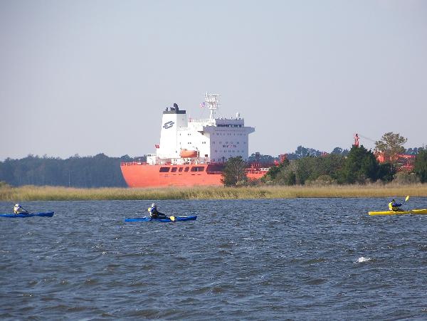
This was most definitely a 5/5 event while some nameless individual was trying to reassure the EMT folks he was indeed fine, I was being swept out to sea by the strong current. I am just happy the man who owned the property where the boat launch I was able to get to was understanding about my being there. When all was said and done I was 1 mile down river. Lets see, strong current, white capes, wind, cargo ship, YEP this was a 5/5.
I would do this again in a heartbeat.
-
Yeah, I saw the large number of available caches. But reading through the logs I also note a lot of "not found"
 and also long times since the last find. That is why I asked for the assistance
 I prefer small short hikes. Last time I stayed in the Embassy Suites. In the area I did the Boulder cache (GCHQJ0) and some in the area of the hotel. I liked the walk in the park for Bouder.
For this time I plan to do at least:
Rail Against The Machine (GCMV63)
These were on my list last time and I did not find the last two then
 . The current plans are that I will arrive on Saturday and then have the Sunday to cache.
Squeeze De Grape is a really cute one, I enjoyed it.
I just did Big Pointy Teeth a couple of days ago, and that one was adorable.
As Dave said Bond Park would be a nice place for long walks. I had just about finished when 4 more were added, I still need to do those.
PM me if you have any specific questions.
PinkD
-
Not sure if this will answer your question but.....
I asked something similar recently, but all I really cared about was getting the info into GSAK so I could load them into my GPS. I got all sorts of wonderful suggestions and help, but could not make any of that work (user error).
What I wound up doing was going to a benchmark page and clicking on the LOC file and it sent hundreds of them to me in a GPX file then I dropped that file into GSAK. It is pretty simple, but got me what I wanted. I am sure you can manipulate them to some extent in GSAK but I don't really know how to do that either.
Hope this helps a little.
PinkD
-
333 discover
-
Sort of getting there.
I have EasyGPS sitting on my desktop
I have 6 different county files sitting on my desktop
Now to figure out how to drop them into the .dat file
-
Thank you.
It just so happens I know BlueCherry in Fayetteville, her cache has one.
-
Thank you.
So to save me from reading a million pages. Are these coins being virtually dropped in various caches then the owners claim them?
-
I can't even find the map
-
How can a Dolphin get one of those cool coins??
-
I downloaded the EasyGPS no problem, it was the BMPGX program I aborted. It did not seem to have a windows installer, maybe it does and I just didn't take it far enough.
I have Windows XP
-
I use EasyGPS. It doesn't do a lot of other stuff, but for uploading (and downloading) waypoints to (from) your GPS, it works like a charm.
What I do is —
(1) download the datasheets from NGS.
(2) run the resulting .dat file through BMGPX to create a .gpx file
(3) Load the .gpx file into EasyGPS. I'll call that FILE A
(4) Open a new, empty file in EasyGPS (FILE B ); I now have two open files in EasyGPS
(5) Using Windows|Tile command, I have FILE A and FILE B side-by-side
(6) I copy the benchmarks I will be looking for from FILE A to FILE B
(7) I protectively save FILE B and upload it to my GPS
-ArtMan-
Is BMGPX hard to download. I started the process but it indicated I needed to extract some files, and after looking at the Read Me it appears I need to be familiar with the command prompts (which I am not). Most anything I load or down load is quite intuitive and the program does it all for me.
I did install the Easy GPS
-
I use EasyGPS. It doesn't do a lot of other stuff, but for uploading (and downloading) waypoints to (from) your GPS, it works like a charm.
What I do is —
(1) download the datasheets from NGS.
(2) run the resulting .dat file through BMGPX to create a .gpx file
(3) Load the .gpx file into EasyGPS. I'll call that FILE A
(4) Open a new, empty file in EasyGPS (FILE B ); I now have two open files in EasyGPS
(5) Using Windows|Tile command, I have FILE A and FILE B side-by-side
(6) I copy the benchmarks I will be looking for from FILE A to FILE B
(7) I protectively save FILE B and upload it to my GPS
-ArtMan-
That is sort of what I did with the 852 points I downloaded this morning (which was not my intention, it just happened). I really only wanted about 10-12. I copied them over to another data base then deleted what I didn't want, leaving the ones I printed out the pages for. The only difference is I just copied the data base over to accomplish my task. I will probably leave the 852 where they are, but not load them into my GPS. I understand about "chasing rabbits" happens to me with GeoCaching all the time.
Thanks ArtMan, hope you enjoyed your time in Raleigh. All I can say is PFF has been very helpful to me!
I will look closer at EasyGPS when I get home.
Thanks
-
Now I am more confused then before. I just want to know how to get there and the coordinates into my GPS without doing it manually. Mostly I just find ones other people have already found and post photos so I can find them. Although I did find one in Pittsboro, NC that no one had logged, and it was just on a corner out in the open.
I usually print out the page anyway so I have the written information. I don't use GSAK for anything but getting the coordinates into my GPS.
-
I haven't fussed much w/ GSAK, & there are others here with much more tech-savviness... but if I'm understanding your question correctly, there's an easy way to download lat/long data for a local area from the Geocaching.com site:
From the GC page of any BM, click "Nearest Benchmarks". The page which opens is entitled "Listing Local Benchmarks - Searching Benchmarks". At the top there's a button labeled "Download all results to *.loc" - or check the boxes you want in the far right column & then click "Download Waypoint File" at the bottom left of the page.
At this point, my download defaults to GSAK (I don't remember if I had to tell it to do so, once upon a time). Load the new info into your GSAK waypoint database, then send the PIDs & lat/long data to your GPSr using the "GPS" tab on the GSAK toolbar.
Hope that made sense....
I have seen that option on the side, I never tried checking the boxes since I had no idea where it would send the information. I could try that and just have a blank GSAK database open.
I also saw there was a tool Easy GPS that will work with the .loc files, that I might be able to download. I guess my question was more how to deal with those .loc files and get them where I need them.
Thanks.
EDIT UPDATE
I just tried checking the box and sending the .loc file. Well it did go to GSAK into the correct data base (I already learned by trial and error to be sure you have it set to the correct data base or it will to to whatever is open). I checked off several benchmarks, and sent it. Instead of sending just the ones I requested it sent 852 or something like that. Oh well, I can isolate the ones I want and go from there. At least it works.
-
I am primarily a Geocacher but have a growing interest in Benchmarks. I run PQ's and dump them into GSAK and load them into my Garmin. GSAK has a ton more functionality, but that is all I pretty much use it for loading caches into my unit quickly.
I saw the thread about benchmark files, but I am not sure I followed the technical part.
Bottom line is there a way to load the benchmarks right into my Garmin or run the PQ. I see there are .Loc files but to be honest I have no idea what they are or how to use them.
I guess I can load stuff by hand, but it is quite time consuming and subject to human error.
Any suggestions from the experienced?
Responses in remedial tech are greatly appreciated

Thanks,
PinkD
 (I have never cached in Ohio.) It's one I found back on '06, and no, it's not a traveling cache.
 The only fee to you will continue to be that you need to be a Premium Member at GC.com because you need to be able to download the PQ that INATN needs.
 Well, has anyone placed a 1K
  and also long times since the last find. That is why I asked for the assistance
Keeping coins in an unactivated cache?
in Trackables
Posted
I have an archived cache I keep my coins in. It is also home to my traveling dolphin who jumps in and out of the treasure chest to attend events or just plain travel.
For me, doing it this way keeps my coins separate form those that actually want to travel.