

VT ARL 784
-
Posts
33 -
Joined
-
Last visited
Everything posted by VT ARL 784
-
Got My Mariplat Back From Magellan
VT ARL 784 replied to Geo Casher's topic in GPS technology and devices
I use velcro, and can mount it in any of the vehicles I regularly drive. -
Strange Question About Magellan Meridian Platinum
VT ARL 784 replied to geospyder's topic in GPS technology and devices
I do most of my GPSing from a vehicle, and the few times I am afoot, I am not satisfied with my current arrangement: a heavy-cotton bag with a loop around my neck. Made it miself, I did. Neck (or shoulder) loop even stitched around bottom of bag for support. But I have to pull the unit out to see it, (another similar style pouch I made has a clear plastic screen stictched in; I may try that approach for the MeriPlat), and I have found it turned off or some other random button having been hit from bouncing against my chest. But it is Very Easy to get to, and maintains good reception. I always try to check out links regarding pouches, because someday, I will design THE ULTIMATE gps bag. Spare battery holder and all. I'll let ya' know. Kate "GeoStomper" VT ARL 784 -
darn, double posted again.
-
When I download my tracks to ExpertGPS, I can see how long I spent at each point, and (if I remember correctly) the time taken from point to point. I don't recall if the same is available in the free EasyGPS. I store my tracklogs after each "expidition," be it driving around for work or driving to explore. At some point, I expect to have driven every road around, and that will be a messy bunch of tracklogs when I look at them on the desktop map!
-
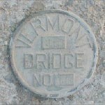
OH this sounds SO CLOSE to my latest obsession, but not exactly, maybe... um. Near some bridges on older VT state roads are 2-3' tall, 4" square concrete markers. Usually on each side of the bridge, on the same side as the direction of traffic, but with the lettering facing oncoming traffic. (Has made it difficult to figure the wording on drive-by studies). They're stamped with the route number (often different from today's), some criptic details I'm trying to work out in conjuction with Placques I've been studying on bridges, and a range of dates from 1954 to 1972. When I first read your entry, I thought you were talking about the same, but I was so psyched to read someone else studying the peculiar roadside minutia that I thought wrong. So anyway, Yes, I agree. This old (and older) markers are fun to document, and like I side, try to figure out a pattern to their data. All this before the plow trucks and salt destroy them all. Thank for raising the subject! VT GeoStomper
-
I've been eyeballing a disc at the base of a lamp post I drive by on weekends; no great parking place nearby. And Ive thought: I see it; my GPS indicates I'm close to it; the pic would probably be very blurry ... Have I "Found" it? Oh, maybe someday I'll stop.
-
um, told me there'd been an error, and when I got back to the page I'd posted twice. Glad I didn't try a third time
-
Interesting. I've been looking for AH3686 in Middlebury, Vermont. Exactly where the description puts the benchmark (said to be a survey disk) I found a similar water cap. Now, the becnhmark was monumented in 1997, so it's unlikely that it's been destroyed and replaced with a town-water pipe. Obviously I need to look around some more, but I found it very surprising when I pulled away the grass and saw that cap instead. And I have found cases where an existing ... plaque/pipe/thingymabob... is used as the benchmark, but that's written into the description, and that's why I made a point to check Marker Type. That's why we're Hunters not just Documentors, I guess.
-
Remember that USGS benchmarks are not included in NGS, in general. The USGS information is mostly still on paper, from what I understand.
-
Recover Wpt/route File From Magellan
VT ARL 784 replied to protocoldroid's topic in GPS technology and devices
A whole new field of semi-self-help: if we can't organize our own brains, maybe we each pick someone else's to organize ... I am only quickly looking through the reply, but I didn't even know there was a Babel forum (though I did go and review the doc before posting). And swapping files to have a seperate New is an idea I hadn't totally developed on my own, so thanks. It might work for what I'm after. As to the file transfer stuff, I'll have to look at it more closely when I have more time. But thanks for the feedback. -
Recover Wpt/route File From Magellan
VT ARL 784 replied to protocoldroid's topic in GPS technology and devices
I'm hijacking this thread because it comes closest to the information I'm seeking. I recently got an SD memory card, and I've successfully Saved to and Loaded from within my MeriPlat (5.12) to store separate tracks. But I have two questions: I'm having trouble using a reader to download the files to desktop (W2K). Not trouble: they're there, and yes, can be opened by a text reader, but I'd like to create files of Benchmarks and transfer them via reader instead of serial, and I can't come close to matching the fields that appear in the opened Card file. (I've created other tables matching ExpertGPS fields and opened them to load onto the MeriPlat). I tried GPSBabel, but I just don't know what I'm doing (I use the frontend not command line). I "Open" the file from the reader (with no extension); on the Open menu, I choose All Files format; then select Meridian Protocol on the next input format. I choose ALl Files again when I name the Output, and Select EasyGPS or GPX as output Format. The second time I tried, ExpertGPS opened, but there was no data. Conversely, I copied a .loc file to the Card via reader, and it appears on the MeriPlat when I opt to Delete Card Files, but it doesn't load. When I Babel the .loc Rte file to Meridian Protocol, I got a syntax error. (Meantime, I Clear, Load, and download each file through the Plat). My other ... conundrum... has to do with organizing WPTs so I don't Save the whole batch along with every new route. That is: I have a file of BenchMarks that I like to keep on the screen, but I record other things of interest as I'm driving around. I'd like to save New wpts separately from the BM file. My guess is this will only be possible when (if) greater selectability is built into the firmware for saving specific waypoints. Currently, I download each redundant file and pull out my new WPTs. If anyone's encountered similar issues and has a suggestion, I'm interested in hearing it. I know this is a long one, but I tried to include details so a response could be more precise without having to ask more questions first. I'd really appreciate any feedback. THanks! -
Mac Gps Connectivity (long, 4000+ Chars)
VT ARL 784 replied to user13371's topic in GPS technology and devices
I appreciate the list of software options, but I do have one request: when known, can their compatiblity with Mac OSs be specified? I'm still trudnling along on 9.2.2. Actually, that's a recent upgrade for me. So it'll be awhile before I hit OSX. I'm verging on ordering a DB9 to USB connector for my GPS (and my Tandy M102- best machine I've ever had!), so I don't have any way to test connectivity yet, but I've been evaluating software when I can. There are some listed here I'm unfamiliar with, so that gives me hope. Great idea. I'll check in when I get my cable and can actually try some of this. For the record, MacSimple does offer a "classic" mode, and has run fine on my system. -
and now, from left field... I checked in because I use spreadsheets to create waypoint lists too. I use ExpertGPS though. I create field names to match those in Expert, save the file as .csv, and Import. From Expert, I upload to my MeriPlat. However, this is all done on the PC laptop I "borrow" from work. I also have an iMac at home, so the general discussion has been very informative to me.
-
Ah, yes WOLF452. That does put me on the correct side of things. So they use this combo of 3 factors when they could just say "on a bearing of 62° from BM"? Clarification, I suppose. "Eschew Obfuscation." WVDan: have I got a site for you! (It prints out at about 7 pages, if I recall correctly.) It's from the Vermont Center for Geographic Information, (vcgi.org), and it lists the formulas to convert everything to and from anything (except grains-of-sand, which was the one thing my friend wanted to convert her road mileage to...). Go directly to the list (no pop-ups/programs to install/etc) at Measurement Unit Conversion Table Or VCGI Home; select Technical Resources Tab, then Tools Options. BTW: The Data Warehouse Tab: Theme Index provides VT downloadable GIS data; and links to Agency of Transportation will lead to VOLGIS, where NGS and VT Benchmarks are retrievable. Thanks to each who contributed to expanding me knowledge in regards to those cryptic crosshares. Keep countin'
-
I definately head for those that haven't been recovered since monumentation. In 1942. Or thereabouts. 'cours, I think I've only recovered one so far (on a wing wall of a small bridge, below a foot of accumulated soil, cow manure, and road stones). Lots of not-founds, but I don't log them yet because I keep going back to look. And look at old maps to make sure the road referred to is the road I'm standing on. And the same with structures. Then again, I also have a pile to tackle when I can get my hands on a metal detector. I do go for more recent ones, if I'm already in the area, just for the practice.
-
This is great! Thanks, Deb, for giving us an "in" and giving a legitmate purpose to what I, at least, consider a "hobby." In regards to the decimal point/s question others have raised, my experience has been with a number of BM set in 1942, and scaled, up to 2 full seconds off both directions. Those I'd feel confident about submitting handheld coordinates on. And I just want to say: BM hunting is so cool! And again, I really appreciate Deb popping in to give us guidelines and feedback. Just my thoughts
-
THanks! So that means: N62W is 60° N of W, i.e. 270+62, =332° ?? Problem is, that puts the everything in the wrong direction, in relation to the witiness post, general north, and road. But since I didn't find it . . . I was pretty sure it was something used by surveyors, and I will also post in Benchmark hunting too. Thanks for the feedback.
-
The following is an example excerpted from Benchmark PG2640, in (er, not in) Middlebury, Vermont. I've seen this type of directional reference before, but I don't know enough about -- I assume (there's a lot I don't know enough about) -- compass reading: Disk is 29' N15E pole; 35' N62W manhole; 54' N77W centerline of road. Does it mean , ... oh bother, I just can't get my head around it. Any help out there? Thanks (I think I found where the bm was, but it looks like someone's dug it out. So I dug down another foot, but still didn't find anything)
-
I'm not sure of the various formats, but Zhana has compiled a list of known State databases. I know that Vermont includes USGS sites, as well as Agency of Transportation's. I download the file in .txt. I've no idea what other States' lists are like.
-
I got Export recently, and it's so worth the $60. Plus, I found a problem moving wpts around in a route. I sent in a an email, and got a response the next day, and a new versions was out the next week! I thought, I not only bought a great piece of software, I bought into a great company! The topo, aerial, and blank maps are all useful and fun (except they dissappear on close-up under 200'). They're like the maps you see on TopoZone, 1:24 series. Basically: Go For It!
-
Macintosh Computers
VT ARL 784 replied to Nomad and the Librarians's topic in GPS technology and devices
Wasn't the orginal issue about Mac software and GPS? Boy I've learned a lot. I'm running an older iMac with 9.2 (this is a recent upgrade from my Performa 7.something) I'm really glad there are a few products out there that haven't totally blown over OS9. I have a MeriPlat, but I'm still lacking the DB9 to USB connector, so I'm still in the software research stage. I have a W2K laptop from work (never know how long I'll have it so try not to get too dpendent on it). The obvious advantage are its variety of ports, and the number of programs written for it. I move back and forth between the platforms with ease, but if I had the money, I'd get a killer Mac system in a heartbeat. -
Do you have "enable internet map retrieval" checked in the "map" menu? Do you get the yellow down arrows on the non-map pages? I figured out in a random manner that maps can be stored locally, if "retrieval" is not selected, but they take longer. And yellow arrows means they're downloading... I imagine Dan may have pointed this out too, but thought I'd add my experience. Do you lose maps at scale of 200' and less (more?)? That frustrates me; otherwise I love the software. I'm using a geateway (logitech) mouse with center wheel. Good luck
-
Hey, Great Topic! I have a MeriPlat and I haven't figured out how to put a lanyard on it, and it makes me kinda nervous out there taking pictures from bridges, and carrying it in a jacket pocket (that's not there in summer). I originally wanted to design a neck-holder type as others have described, but, I also carry (wear) a camera, sometimes with a rather large lens. So I thought about a belly-mount. Now that would look doofy. So now I'm considering a hip or thigh mount. Hip's fine without layers of coats and jackets. It doesn't have the advantage of immediate visibility, but it would be easily accessable and not terrible sheltered from satellites. Or I can just see myself barging through the underbrush, loaded with camera and GPS strapped around my thigh. Hum... Whatever attachment-form it takes, it will have see-through front, place for (2)AAs, and be flexible enough to control the buttons through the cover. In a couple of the vehicles I drive on a regular basis, I have velcro on the dash upon which I plant the fixed mount. In the vehicles that don't have that, I have found the MeriPlat usually wedges nicely between the windshield and dash - that rubber-like edging keeps a grip. One rig I have to lash the unit to the MagLite on the dash using the strap on my home-stictched pouch. My point: there's always a way... But it's fun to think of the best way! VT GeoStomper (ARL 784)
-
Hi, great job. You've included the one and only I know of for Vermont, but somewhere I came upon one for Arkansas. It appears you must request the information from the Dept of Trans, but the site is http://www.ahtd.state.ar.us/info/FOI/FOIRe...ecord_Number=15. I originally posted it in http://forums.Groundspeak.com/GC/index.php...ndpost&p=771595, Benchmark Forum "Arkansas BMhunters"
-
Sorry for the long delay in response; I lost trackk of the thread. I don't know anything about the site I referenced, except what I see. In Vermont http://vcap.aot.state.vt.us/pages/volgis.htmVT Online GIS -- Benchmark Retrieval, the website displays data in the standard NGS datasheet format. The site I for Arkansas may or may not include NGS (I assume that's what you mean by USGS? Since USGS doesn't have a database on the web... unless you've found something you could share with me...) but will provide information on benchmarks established by the State. Again, in Vermont, thats Agency of Transporation among others. I guess the best way to find out is try it! Good luck.