


shivia
-
Posts
188 -
Joined
-
Last visited
Posts posted by shivia
-
-
Very slow to refresh the display when we drag around the map.
-
- The maximum number of points problem is now fixed.
- My next concern of my track is how do i tell geko201 considers my track that i download as track, not as a route, even that file is really a track on mapsource CN2008? i.e no need to tell me "ready to navigate", just show me a track as is. thanks.
-
- how do i reduce the number of points. My routes have usually 500 points approx. thanks.
Manualy (I do not know of a program doing that automatic - but that kind of program may exist)...
- Yes, you gave me a idea to try Wingdb. I set Wingdb to "convert route to track with via point only" and i get the track downgraded with only 75 points (originally 337 points)
thanks for your help.
-
Hello. Can I download a routes created with mapsource (CN2008) to the geko 201? Theses routes are mainly used on 60csx.
thanks.
Is possible.
You need a garmin serial cable for the geko.
Make sure the route length is within the GEKO's limit, maximum 20 routes with 125 waypoints each
(I have a geko 301)
- how do i reduce the number of points. My routes have usually 500 points approx. thanks.
-
Hello. Can I download a routes created with mapsource (CN2008) to the geko 201? Theses routes are mainly used on 60csx.
thanks.
-
One of the best among these advanced chargers, my opinion, is the Maha MH-C808M. More easy using than 900, one button pressing and let the unit do all the rest. it also takes many batt sizes.
http://www.thomas-distributing.com/maha-mh...ery-charger.htm
-
Hi members, do you know if Colorado displays a heart monitor and cadence? or just record these data in background? thanks
-
Red90, can I download the Ibycus Topo 1.22 to my 60csx? It shows fine on my PC MapSource. thanks.
-
1/ I run mapsource now in french language. how do I change it to english?
2/ I see that I have many MapSourcexxx.dll files (xxx= many others language). Can I delete them because I know I never use them.
Thanks.
-
So, in one word, I cannot backup or whatever action to install this pre-loaded contain to MapSource at all? thanks.
-
Hello, can I make a backup (or copy) of the pre-loaded CN NT 2008 and use it in the Mapsource like the dvd version? thanks.
-
Garmin Geko 201, few years ago.
-
On my 60csx, how do i know (or see) the iono and/or clock corrections? Is there the signs, icons or something else telling me there are corrections? thanks.
-
...The ground based stations are typically found near major airports. Makes sense, since it is the airport industry that developed WAAS for use in their planes anyway...
- hello. do you know some website showing these ground stations locations? I just curious to know the closest ground station from Quebec, Canada. thanks.
-
I use Ray-O-Vac Hybride rechargeable batt. Very confortable with it. I always bring a extra set of batt, in case of. But I never need to change them during my 8 or 9 hrs bicycle's ride.
-
Do you have any idea for that issue? thanks.
- FYI, I should re-enter my CN's unlock codes in NRoute. And bingo, I have all detailed map displayed. It seems nroute does not take infos from mapsource automatically.
-
Just a thought: You must have the unlocked GPS connected to the laptop for nRoute to show the map with full detail. Otherwise only the base map will show.
- what do you mean by "unlocked" gps? I always use my gps to upload/download routes/tracks from/to mapsource. And it always works very fine.
- Now, the first time I install NRoute, and try to use it. Then I get this message.
-
Do you have any idea for that issue? thanks.
-
Hello friends, I see a message on the lower right corner of my NRoute screen telling detail maps locked. I only see a main autoroutes with my red triangle position.
- But I see all of them unlocked with all details on my pc and gps.
- some settings I should do in NRtoute? thanks for your help.
-
After I return from a Geocaching adventure, I download the Tracks and Waypoints to my computer. I save that day's tracks with a name that includes the day and location. For instance, the other day I went caching in the desert. That file is named: 100807_Desert. On my computer, I actually have Tracks going back to 2005.
 I can open them in Mapsource, edit them, share them with someone, or upload them to my GPSr if I need to follow previous Tracks.
By doing a "screenshot" of the tracks on your maps, you can get hike Profiles like this:
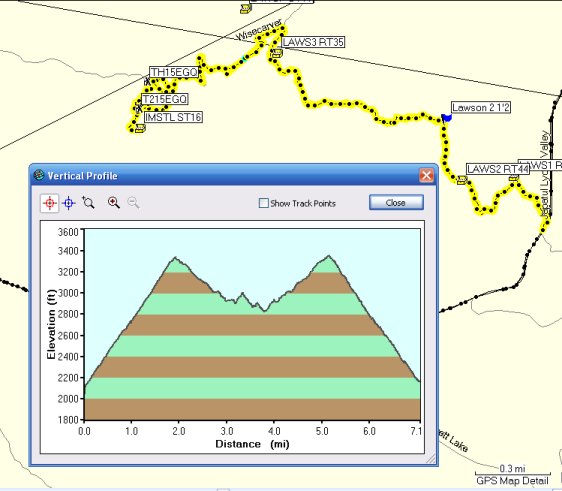
- how do you obtain a vertical profile window? Is there a CN or Topo map? I have a CN 2008 and I can't get this vertival profile view. Do I miss some functions on mapsource? thanks.
Right click on the Track and choose Track Properties. From that window, choose Show Profile. I move the first dialogue box way off to the side so I can have just the Profile showing over the map with the Track.
- my "show profile" button is grayed out. What's wrong with my track?
-
After I return from a Geocaching adventure, I download the Tracks and Waypoints to my computer. I save that day's tracks with a name that includes the day and location. For instance, the other day I went caching in the desert. That file is named: 100807_Desert. On my computer, I actually have Tracks going back to 2005. I can open them in Mapsource, edit them, share them with someone, or upload them to my GPSr if I need to follow previous Tracks.
By doing a "screenshot" of the tracks on your maps, you can get hike Profiles like this:
- how do you obtain a vertical profile window? Is there a CN or Topo map? I have a CN 2008 and I can't get this vertival profile view. Do I miss some functions on mapsource? thanks.
-
... Carfully bent tabs to make firmer contact with pads, reassembled making certain rubber seal is perfectly in place. Tightened all 6 screws evenley and tight...
- my friend bends these tabs towards the contacts like you. AND "reinforce" them with a small piece of high density rubber behind the tabs giving them more spring load force and at the same time, making sure they don't return back to the "bounce" position. No more power off. I'll do the same thing.
-
Hello, can I connect my usb memory stick to the 60csx using mini-usb/usb cord for transferring routes or tracks? thanks.
-
Try this post
- yes. it's one of them. the other, I think, have 3 or 4 photos showing how to disassemble the unit. thanks
 I can open them in Mapsource, edit them, share them with someone, or upload them to my GPSr if I need to follow previous Tracks.
MapSource 6.14.0.1 Beta
in GPS technology and devices
Posted
Me too, i found the beta version is zoomed little bit in more than present version for the exactly same scale.