


polskikrol
-
Posts
294 -
Joined
-
Last visited
Posts posted by polskikrol
-
-
While we are planning on meeting up in Centralia, I and ThirstyMick will not be going to Applebees. Instead we are planning on hitting up Barley Creek Brewing Company (website) for lunch. They open up at 11:01 AM and thats when we plan on being there to allow for enough time to get to Centralia at the same time as the bunch going to Applebees. Address is Sullivan Trail and Camelback Rd., Tannersville, PA.
After Centralia we are planning on having dinner at Selin's Grove Brewing Co (website). They are about 15 miles west of Centralia at 121 North Market St. Selinsgrove,Pa.
Anyone interesting in sampling some brews while out in Pennsylvania?
-
Does anyone know if its possible to perform Waypoint Averaging with the Colorado Series? Last time I checked the firmware did not allow for this. Out of curiosity, is this function available on the Oregon Series?
-
I have been asked to teach geocaching to several groups of kids while they are at summer camp. The camp is located on a large ranch and the owners would like to set up a whole series of caches on the property for this year and future years. BUT they don't want to invite the world onto thier property. Is there a way to set up private caches on geocahing.com or must I just set them up as waypoints with my own cache data sheets and hints etc?
Using geocaching.com would give them training on how to use the website and would expose them to the big world of public caches.
Any advice?
Unfortunately any caches listed on geocaching.com should be open to the public to the best of my knowledge. The only possible restriction is Members Only caches but under that classification the paying membership at geocaching.com would have access to the cache coordinates as well. Believe you would have to setup your own waypoint lists or setup the series on public property for all to enjoy.
-
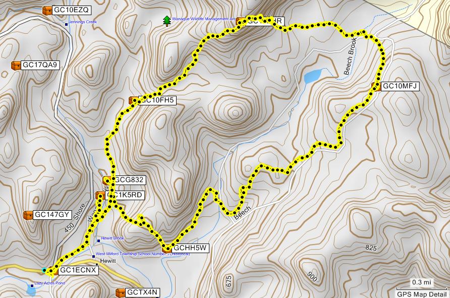
Here is a hike I did on Sunday with slukster and ThirstyMick at Long Pond Ironworks State Park:
Track Log:
Elevation Profile:
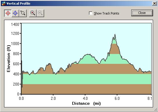
Track Log Specifics:
Points: 870
Length: 8.1mi
Area: 1.2 sq mi
Elapsed Time: 7:32:13
Avg. Speed: 1.1 mph
Trail Notes: Took The Highlands Trail from parking and then followed the Yellow Trail for a little bit until we got to a dirt road going to The Homestead. Then we took some old dirt roads and bushwhacked through the swamp and a steep hill to get back on The Highlands Trail. We were planning on a much longer loop hike to grab an extra 5 or 6 caches but do not believe this is possible in Winter and fresh powder. Given summer and extended daylight it would be possible to follow the dirt roads into New York State where they intersect The Highlands Trail with not need for the bushwhack. Nevertheless, we had quite an adventure and lots of fun bagging 6 caches and hiding 4 new ones

-
did u see the article about one person that turned his cell phone on so if he did end up crashing and not surviving, the would be able to track him using the the gps in the phone
Its funny he actually thought his phone was waterproof. Good idea on the GPS Tracking, bad idea on thinking it would survive the Hudson River.
-
Would appear my original post got eaten :<
Monday is Bank Holiday for me so I am looking to go hiking in Harriman. Perhaps the following will be the agenda: http://forums.Groundspeak.com/GC/index.php...6009&st=50#
However, also open to other hike ideas in the Ramapo / Wawayanda area. I know Packanack has a few new caches I would like to hit up near Iron Man. Perhaps someone has a list of those Sterling Forest secret hides and is willing to give some of them a shot

-
Missing toenails? Not sure how this would happen.
- Hiked 74 miles in the Smokies across about 7 days w/o any missing toenails. This would include probably an elevation gain of 10,000+ feet.
- After hiking 22 miles in the Grand Tetons and ruining a pair of shoes ThirstyMick did not lose any toenails. Even afterward when she hiked a few mountains with new non-broken in shoes, no missing toenails.
Sounds like you may need a trim and use socks

-
I try to time the trips so that we get to camp late in the day. By the time I gather wood and cook dinner, it's usually near dark and time to start the fire.
If I do have spare time I read. I usually have a paperback along and will bring some magazines and newspapers.
Same when I get up in the morning. I find a nice view, brew some tea, bring my book and wait for my companion(s) to wake up.
If I'm with my friends we usually drink - a lot.
Brian, if your drinking a lot with friends do you carry a sixtel with you all the way up to the shelters? That would be heavy, no?
On a serious note, I usually try to time getting there at night fall. Sometimes this does not work well and we end up using a headlamp for the last few miles or so. Just came back from the Smokies and we arrived at one Shelter at night fall when we had reservations for the next one. Spare time? Seem to never have spare time! Relatives have given us hammocks and such and its a good thing we always forget to take it with us cause it would just end up being dead weight. When it comes to hiking we like to bite off a little more than we can chew but not enough that we choke

-
If you are going to be there for the Inauguration I would only recommend the Virtual Caches! You probably do not want to be looking too suspicious.
I was there a little under a year ago with ThirstyMick and another friend exploring DC and the Virtuals were quite good. They bring you to the lesser known interesting locations as well as the must see locations that you would visit anyway. Bring lots of memory cards for the camera and enjoy!
PS Be sure to enjoy all of the wonder Brewpubs in DC such as Capital City Brewing, Gordon Biersch Brewing, and Chophouse & Brewery. Perfect for dinner and some brew after it gets too cold walking around when the sun goes down.
-
weathernowcast....what about having a vote on the location at the next meet n greet at fudd's?
If we have a vote, we still need to be able to have a location we can get the trash out.
Locations that have been mentioned above.
Garret Mt. (x4)
Ringwood State Park (x2)
Split Rock (x2) up on the side of the lake/east side of lake
Friendship Park
Rifle Camp
Norvin Green
Wawayanda State Park
Tourne County Park
Meadowlands - DeKorte Park.
Meadowlands - Mill Creek Marsh
piece of land in Mahwah owned by the Passaic River Coalition (confluence Ramapo and Mahwah River)
Federal Hill
Long Pond Ironworks SP
south mtn reservation.
Would we be able to bring it to the local municipality public works? Perhaps someone with a pickup truck? Not sure if this would be possible... we could always segment the bags into smaller ones and stuff them at our local convenience store
 Seriously, would a pickup truck and public works yard be an option?
 -
And a unique log for every find, no cut-and-paste. that's what impresses me the most! Glad to have met you at some Long Island events.
Definitely one item that stands out - I have also noticed all logs generally have pictures, track logs, and even detailed commentary of experience. Congrats Stayfloopy and thanks for taking your time into the logs!
-
Rumor has it that Pofe's a she....
I'm curious why he (she?) actually unarchived it and why not the others?
I think because one of the cache locations looked like this (can you spot the cache?)
: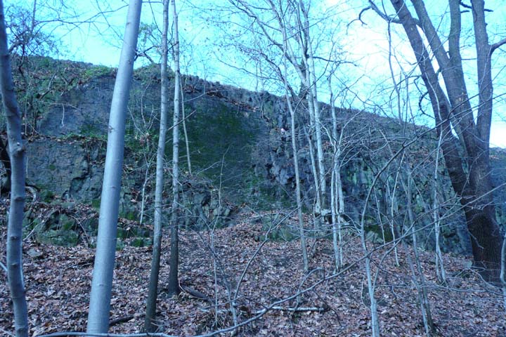
The one she/he unarchived passed the "no rock climbing in the park" test.
This was a good cache - had fun retrieving it however ThirstyMick whacked her back standing up under the tree overlooking the cache on the cliff.
-
Before I started geocaching a good friend of mine (with whom I have been on numerous outdoor adventures with during college) gave me one of those 50 Great Hikes in NJ books. It was quite tattered and I am fairly confidence he did most of the hikes in the book. It would be several years later that I would learn the book was written by a fellow geocacher. Small world. My friend actually stumbles upon geocaches all the time while hiking or biking throughout the Northeast, however, he is not much for technology and as such does not use GPS devices (even though he is an electrical engineer!).
Small rant while listening to mindless heavy metal rock but my point is 1) small world and 2) very good book.
-
May be interested in this on depending if I have to provide on-call coverage for work or not. Have been there once before prior to geocaching and have pictures of some of the virtuals / earthcaches. Might be an opportunity to log them and further explore the area.
Would anyone be interested in checking out some Allentown Brewpubs afterward ?
-
Bummer, just came back from the Smokies. Would have definitely been interested in going out for this hike and then attempting Ironman afterward. Hope everyone made it out and had fun!
-
As an aside, just came back from the Smokies having hiked 74 miles on vacation and came across no bears at all. While in NJ see them all the time.
-
67!
If your family is like mine, the kids will have at least 20 apiece!

Merry Chistmas, thanks for the cointest
-
Actually, Joisey is historically cut into East and West Jersey.
Until they cut Little Egg Harbor from Burlington, and added it to Ocean, to keep Burlington from having a coastline, and qualifying as a Coastal County. Then, to make matters worse, they formed Mercer County from parts of Middlesex, Somerset and Hunterdon! So, like it or lump it, Central Jersey is that part of East Jersey that those of us in North Jersey evicted. Danged Centralists!If memory serves, no one evicted us from anywhere. We seceded!!
Seriously though, I think ones of the main reasons the Central Jersey group was formed was that there were never any events that were close to us. The ones from North Jersey were always waaaay north, and the ones in South Jersey were always waaaay south. The creation of Central Jersey was a good way for those of us in Monmouth, Middlesex, and Mercer to meet and not have to drive 2 hours to get there. Hmmm, if the Parkway is 172.4 miles then you can pretty much get to anywhere in the state in under 2 hours
 If your in Central Jersey you have no excuse not making it to any North or South Jersey event
-
Hmmm... SOME of us in Joisey are living in a fantasy world. When I was growing up there were two area codes. 609 and 201. 609 was South Jersey and 201 was North Jersey. There never was a CENTRAL joisey. Until some very confused people decided that they didn't like either and created it! I think Key West and some place in Montana tried that too. People laughed!
Vaguely remember my home area code being 201 then 908 and finally 732 through the past 20 years or so. Suppose you could probably figure out what town that used to be more or less

-
Good well done! Congrats to all who searched for 'Sight Unseen' (GC15NP2) today and beat the geocaching challenges of body & mind.
The following milestones were had at the final stage (after only about 9 or so previous stages):
mmacgown: 4000
weathernowcast: 1500
Peeves79: 800
The following geocachers made the find today: bonick0, guybot, hallycat, mmacgown, mustard+red, Peeves79, Sakiman, StarBow1er, thezookeeperleft, weathernowcast. Congrats to all on this high accomplishment!
-
I was a little confused, my understanding was that to be able to log, you have to have found at least one cache of every possible difficulty/terrain combo (i.e. 1/1 thru 5/5), and found at least one cache of every cache type.
Do you have to find a Wherigo cache as one of them? I assume this was created before that type and only a somewhat small minority of cachers have the Wherigo equipment?
This guy sounds interesting.....
Checking the Ohio one it would appear that Wherigo is not required as you need a capable GPS. Would presume that rules may vary from state to state implementation.
-
Running out of money so the price is now $380.00
Thats a little pricey as this model line has been price reduced. Only 350$ brand new! Not to mention this is 350$ for the 400T model! http://www.rei.com/product/754440
I just bought the 300 and 400T models recently for 400$+ so the price reduction hurts me as well
 Wish I was buying these now... but then again, I would not have as many finds.
 -
Found a spot yesterday in what I believe is Long Pond Ironworks SP (or possibly Norvin Green SF) that is in dire need of a CITO.
What are the coordinates / trails in question? Any idea who we should contact? If its cleanable in the cold lets setup a date
-
[quote name=
Spotting #2 (Geocacher? Unknown)
Today saw a grey SUV stuck in bumper to bumper traffic on Route 24 near Madison, NJ with two GEO stickers on the back and what appeared to be a DunkinDonuts sticker. There was no travel bug sticker visible from the back. Curious to know who this was! Anyone know?
Guilty as charged. I really must swap over my GER-IRL license plates from my wife's car! However, It's not a SUV (implied: gas guzzler, planet hater etc etc), but a family friendly minivan (read: involved dad, room for the in laws etc etc). Actually, the DD magnet and one of the GEO magnets are compliments of EagleTrax - Thanks Karen!
It was dark and rainy... apologies for calling it an SUV. I now remember the model which was an Odyssey
If you had those plates the ID would have definitely been easier!


 Seriously, would a pickup truck and public works yard be an option?
 Wish I was buying these now... but then again, I would not have as many finds.
Sunrise Step Off
in Northeast
Posted
Lets just hope that Pofe reviews the caches placed by ThirstyMick and Slukster that are the other pieces of the puzzle! I posted our tracklog of the hike in the Great Ny/nj Loop Caches thread.