


polskikrol
-
Posts
294 -
Joined
-
Last visited
Posts posted by polskikrol
-
-
Many thanks for the support today ThirstyMick, BrianSnat & SteelNDirt! I know the weather this morning looked dismal however we were quite lucky after hitting the water with the watercraft! Had a spectacular time today and will cherish the memories!
Full details of the adventure can be read about in my post: PK's #2000.
Kayaking TrackLog Statistics
Points: 291
Length: 3.2 mi
Area: 81489 sq ft
Elapsed Time: 3:28:55
Avg. Speed: 0.9 mph
Note: Does not count datapoints for Stage 1 replacement as the GPS was left in the car.
Hiking TrackLog Statistics
Points: 548
Length: 5.8 mi
Area: 1.4 sq mi
Elapsed Time: 2:35:36
Avg. Speed: 2 mph
-
Is that rain or shine?
Yup, currently on #1999 and planning on doing island hopper on Saturday rain or shine. What time would you be planning on getting there? If there is time in the late afternoon might even do a small loop north of the lake.
-
That would make sense then
 Wish reviewers were able to set an "out of office" or something on their accounts when one attempts at correspondence.
 -
Would anyone know if there is a holdup with Earthcache approvals? I have been struggling for close to 1.5 moths to get a new one published and recently have not been able to receive a response for over 2 weeks! The following is an order of events:
February 22nd - Initial Submission
March 3rd - Initial Rejection
March 4th - 9th - Email Dialogue Regarding Clarification
March 10th - Completed 1st Revision
March 10th - 2nd Rejection
March 11th - March 19th - Email Dialogue Regarding Clarification
March 20th - Completed 2nd Revision
March 30th - Followup Email Regarding 2nd Revision
April 5th - Still No Response Regarding 2nd Revision
Initially emailed on March 20th but still have not received even a simple "received your email and will review it" for well over 2 weeks. Everything OK with the reviewers? I am anxiously waiting to iron out the kinks with my Earthcache and to get it approved.
Please advise
-
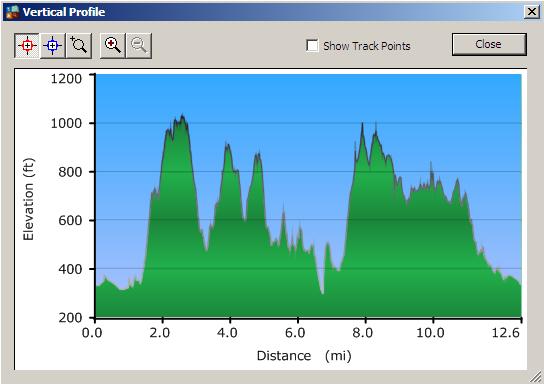
Stonetown Circular Trail (Red Triangle)
Tracklog Summary
Points: 1388
Length: 12.6 mi
Area: 2.7 sq mi
Elapsed Time: 9:03:24
Avg. Speed: 1.4 mph
Notes: About 1.5 miles of driving are factored into the above summary as this is how Stage 1 of 'Windbeam along Highland Trail' was attempted.
Tracklog
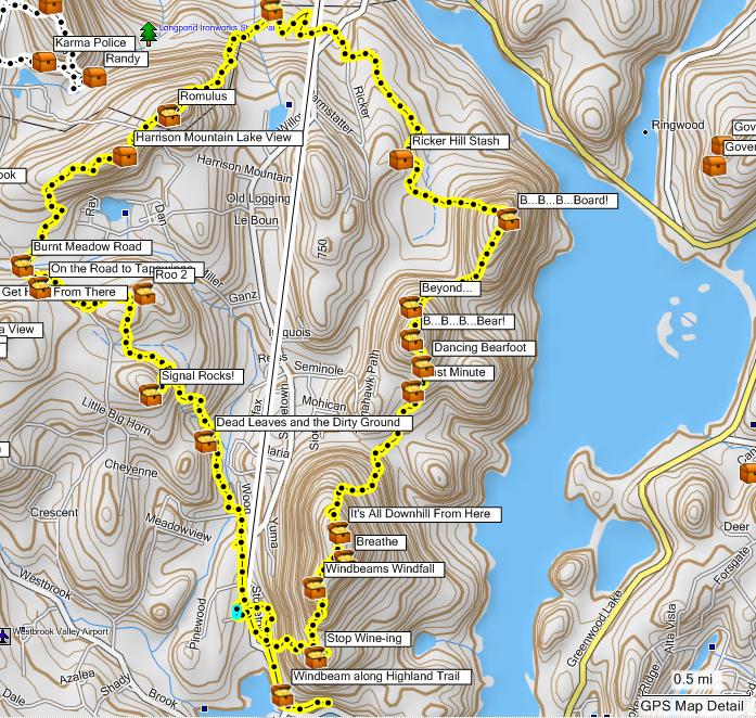
Vertical Profile
New Caches
Placed the following new caches while we hiked the Stonetown Circular Trail:
GC1PAFH: Ricker Hill Stash
GC1PAFK: Harrison Mountain Lake View
-
With the four new caches in Bear Mountain State Park on Dunderberg Mountain a nice loop hike can be made which includes the following caches, GCY0WQ, GC1MWFG, GC1MWFZ, GC1MWGB, GC1MWGK and GCY0WG. There is also a nearby virtual cache GC8FD5. Its a great hike with some wonderful views and the caches are all placed near sections of the never completed Dunderberg Spiral Railway.
A lot more caches than that can be found!
 Bear Mountain Loop Hike
 -
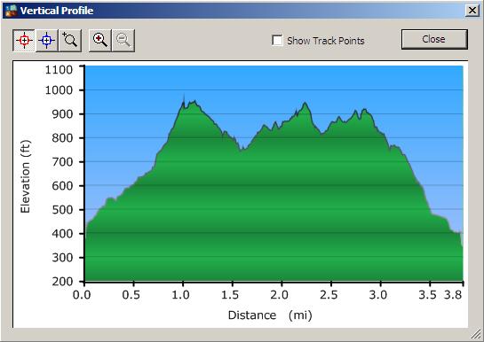
Had lots of fun this morning tackling Weathernowcast's Cloud Series in Long Pond Ironworks. The weather may not have been the best however one could not have asked for better company!
Tracklog Summary:
Points: 456
Length: 3.8 mi
Area: 0.2 sq mi
Elapsed Time: 3:10:15
Avg. Speed: 1.2 mph
Tracklog:
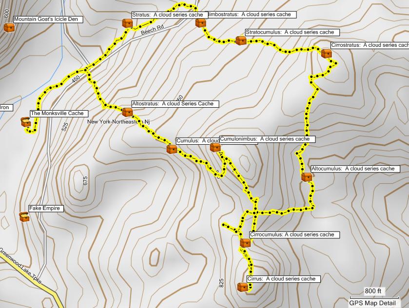
Vertical Profile:
-
Looks like one of the minions of Satan got me :< Think the 10 mile hike around Stonetown Circular is where I got him from or this morning in Lond Pond Ironworks. Considering I have a nice bullseye on my inner thigh I will be going to the doc tomorrow for some antibiotics after work.
-
Thats messed up... at least they left the contents unlike my one ammo can that got muggled in Rifle Camp Reservation a while back. Any North Jersey cachers work in forensics or know anyone? Maybe we can lift some prints.
-
What will be the coordinates for parking for Sunday at 7:30AM ?
-
Making me go back to that park again ?!? The agony..

-
Here is a hike I did recently at Bear Mountain: Tracklog & Elevation Profile
-
Although I had convinced myself that it was time to try and put the geocaching aside for a month to allow for shape up for the NY Bike Tour, I see that there is a series of caches near Longpond, that are newly placed and look rather inviting. And if my view is not clouded, I would like to spend a couple of early Sunday hours looking for some of them. Anyone interested ?
If you are referring to Weathernowcast's new caches I may be interested... perhaps grab these before ThirstyMick even wakes up! What time, 7AM ?
-
Perhaps its a good thing no one joined me on this one... looking at the tracklog information can hardly believe it was over 20 miles!
Tracklog Summary
Points: 2292
Length: 20.6mi
Area: 3.1 sq mi
Elapsed Time: 11:16:37
Avg. Speed 2 mph
Tracklog
Vertical Profile
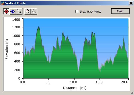
Trail notes will come after I have completed logging all of these. Definitely had lots of fun and would recommend this hike to anyone in shape to complete it!
-
That looks like a do-able hike with some decent elvation gains and losses, but that's Harriman-Bear Mountain Park. You climb up and down the same 400 feet all day long. Its been a while since I've dome some of these caches but I'd suggest dropping the first one, GCJKZV. If I remember correctly the multi takes you quite a ways up West Mountain. The next one on your schedule is back at the parking lot elevation.
Sorry I won't be able to make it but if you decide to try for the extra caches, I'll be driving past the Route 9W entrance to Doodletown around 6:15 PM on Monday night and will be glad to shuttle cachers back to the Anthony Wayne lot.
Definitely lots of ups and downs today... started at 8:30AM and ended at 7:30PM while picking up 20 caches including the Multi. Did Stage 1 first thing and Stage 2 on the way back on my counter clockwise loop. Well the Final was too close to pass up even with fleeting light. Will post details and track log when I have a chance. Currently recovering..
-
I have this cache Top of Reservation - GC1KG5W located in Eagle Rock Reservation in West Orange, NJ. I have received some log entries comenting on the proximity to the homes located on the outskirts of the park. The cache is located on a rock face that you approach from above but don't end up going all of the way down to level ground to retrieve. You can see the back of the homes from the cache location but at no time do you leave the park property or come close to the homes but the homeowners can see you accessing the cache from their back porches and backyards. Some of the veteran cachers in the area have made comments inferring that this location isn't a good one and I can see where they are coming from. My question to you is should I relocate this cache or would you consider the homeowners as "muggles" which are part of the game? Maybe someone who has visited this cache will comment. I respect the opinions of my fellow cachers and would not want to cause anyone any problems while accessing my caches. Thank you in advance for your advice.
Having found this cache I thought the rock face itself was a good location. However, given signal bounce I at one point found myself at the bottom of the rock face and felt a little uneasy. Would have preferred such a hide with a little less exposure. However, playing devils advocate... 1) What makes this different from an urban magnetic micro across the sidewalk (10 feet or so) from an apartment complex or condo and 2) If you wall off the cliff face the odds of being rescued are quite high. In my opinion its a toss up but if you were to find a similar location with less exposure to possible uneasiness I would relocate it.
-
That is a really good picture! Have seen lots of ticks but no bears so far...
-
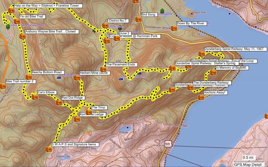
Planning on parking at the Anthony Wayne Parking Area (N 41 17.874 W 074 01.632) and starting the hike at 8AM. Closest cache that can be referenced for parking is GC9CE8 - Ye old Bike Trail.
The following caches are planned for the day (time permitting of course) in the order they would be attempted:
GCJKZV - Help on the Way > Slipknot > Franklins Tower
GC9CE8 - Ye old Bike Trail
GCKHE7 - Anthony Wayne Bike Trail....Cloned
GCJKPM - Beechy Bottom Road
GCPVX1 - Cat's Elbow
GCPVXB - Red Dot Ridge
GCNGWT - Kamikaze Ledge
GCPVX6 - The Timp
GC1MWGK - Dunderberg Spiral Railway: Tunnel
GCY0WG - The Dunderberg Railway
GCY0WQ - In Memory of BigBill6
GC1MWFG - Dunderberg Spiral Railway: May 11, 1967
GC1MWFZ - Dunderberg Spiral Railway: Top of the Loop
GC1MWGB - Dunderber Spiral Railway: Stalter's Spring
GCHCFZ - The Pavement Ends
GC6DC0 - Corporal Nobbs @ Harriman Park
GCHD8D - June 2
GCC855 - District No.7
Time permitting the following would be optional (in order of importance):
GC2D07 - Herbert Mine cache
GCH4H4 - Bike Trail number 2
GCPHHG - S.W.A.P.S and Signature Items
GCQA7V - The Pines
There are many trails providing for shorter loops if daylight is lacking.
PK
-
Is there a chance that the Psycho Urban caches could be opened up for public viewing? At the moment the #13 cache, and a bunch of the others too, are members only listing.
Agreed, us lowly non-members cannot view these caches.
$30
If its only $30 bux then you can buy me a Gift Membership
J/K - I really dont want one. Purpose of my post was to indicate that if you want to get interest in the cache and make the documentary a success you may want to open it up to all members. Are you looking to promote the sport of geocaching or just premium membership sales? -
Is there a chance that the Psycho Urban caches could be opened up for public viewing? At the moment the #13 cache, and a bunch of the others too, are members only listing.

Agreed, us lowly non-members cannot view these caches.
-
"Boooo" for having to work on my birthday
or else I'd come out with you.You can always call out sick... not that I have ever done that on my birthday
-
Planning on venturing out to Bear Mountain on Monday, March 23rd. Looks like I will be working on Saturday and will be taking Monday as a Comp Day. Thus, planning on getting to the park sometime around 8AM.
Will post tentative trails list and caches this evening.
-
Let's hear it for yankeepride - who made milestone find #800 today, 16 March 2009, at Best Lake Cache.
Well done - CONGRATS!!!
Congrats Steve!
-
Also, there will be a new trail going in to connect the Hasenclever with the Monks trail. We can use a crew to build it. I was talking with the guy who is in charge of it and mentioned that perhaps a group of geocachers would like to pitch in on a Saturday and complete the trail. He is still awaiting final approvals, but would love to have the NNJC come down and build the trail. With a large enough group it can be done in a day.
Pick a Saturday (hopefully before May) and I'm in. Call it a CITO event and everyone north of 78 will turn up.
Agreed! Pick a weekend Brian and setup a CITO event - Im in.


Trip west for the Allegheny Geotrail
in Northeast
Posted
Venango County we already completed after finding out about the Allegheny Geotrail during the Pittsburgh Geocoinfest last year. Planning on driving all night after work on Friday and tackling the remaining 9 counties probably in a clockwise manner.