


polskikrol
-
Posts
294 -
Joined
-
Last visited
Posts posted by polskikrol
-
-
As today was a bank holiday, good time to enjoy the day off at Bear Mountain
 Ended up hiking 17.3 miles over 9 hours on a nice lollipop loop with highlights including Bear Mountain Bridge, Anthony's Nose, and Bear Mountain.
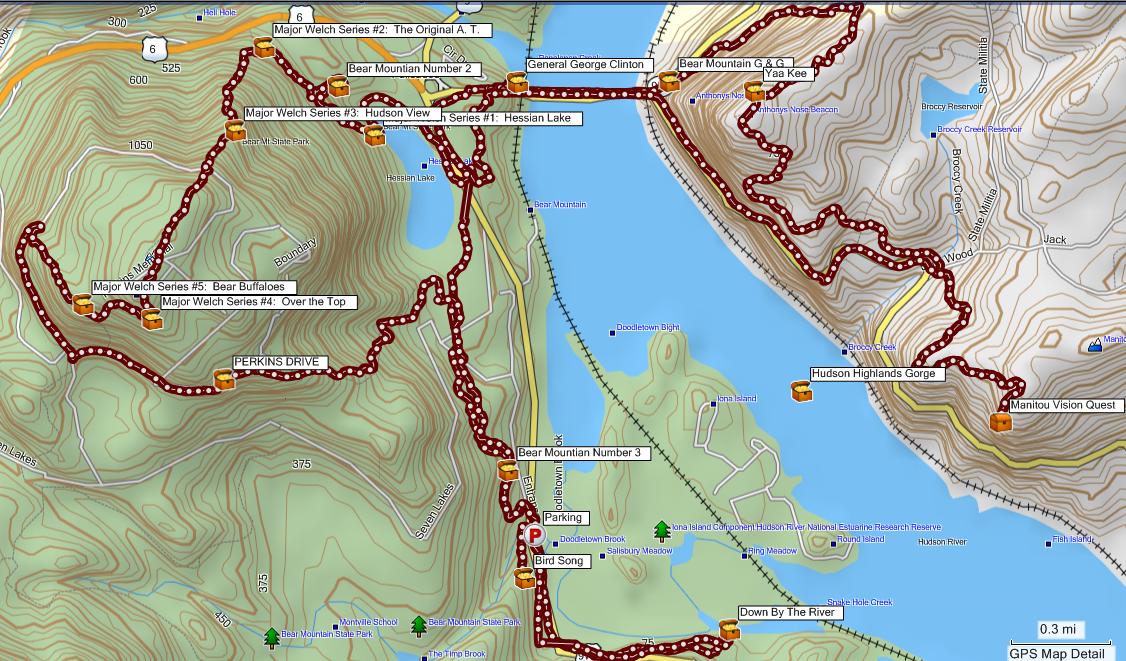
There are a few other caches that can be grabbed near Doodletown if you want to forgo the Camp Smith Trail (Blue). The following was the trail order: 9W Bike Path -> Cornell Mine Trail (Blue) -> 1777E -> Appalachian Trail -> Route 202 -> Appalachian Trail -> Camp Smith Trail (Blue) -> Route 202 -> Appalachian Trail -> Unmarked Path -> Major Welch Trail (Red/White) -> Appalachian Trail -> Unmarked Path -> Appalachian Trail -> 1777E -> Cornell Mine Trail (Blue).
-
Another park I found out is open 24/7 is Monksville Reservoir. Think I will need to go back there in the spring with the kayaks and camp over a weekend

-
Logging Wherigo's redirects to http://www.Wherigo.com/error.aspx?aspxerro...=/logs/log.aspx. This is a nice error page which causes one to retry submitting the same content... with the same error. The logs do successfully post and those I had to delete my duplicate posts... however, the error being returned when simply selecting "Submit Log" should be corrected.
-
Ramapo Valley County Reservation
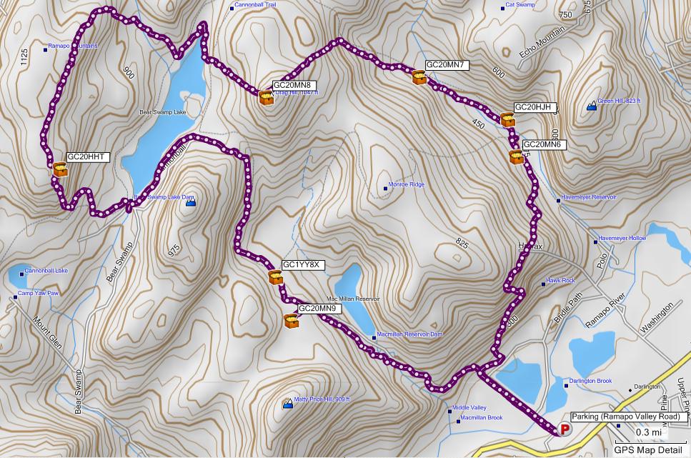
Notes: Really nice 8.8 mile loop hike which allows you to bag the new caches recently put out by weathernowcast and wjgrun. Parking is at the main lot off Ramapo Valley Road (Route 202). The following are the trails which were taken: Silver Trail -> Schuber Trail (Orange) -> Red-Silver Trail -> Shore Trail (Blue) -> Cannonball Trail (Red) -> Bushwhack (PK's favorite type of trail) -> White Trail -> Hoeferlin Trail (Yellow) -> Shore Trail (Blue) -> Bushwhack -> Pipeline -> Halifax Trail (Green) -> Silver Trail. Total hike in the snow should take around 6 hours if you take your time.
THere are actually a few more caches along this route. I can think of 3 or 4 right off the bat.
Yup, there sure are... however, already found those previously so they were not captured in this tracklog screenshot :[
-
I'm still not seeing what the problems are. I'm only bringing it up, because people's comments seem to be so far away from my experience, that I wonder if I'm either out of it, or....something (yeah, ok!).

I really dislike change. I'm usually one of the ones sitting there being upset, even though I don't usually say much because I know from experience that I'll get used to the change eventually. I disliked when the site changed from the bright kelly green to the more mellow sage-ish green we have now (many years ago, I'm dating myself). But now, of course, I love this green better than the almost neon one before that.

Anyways, this cosmetic change seems to be very slight, to me. I would have barely noticed it if it hadn't been announced. Mainly the same, but with a slightly more structured feel to the pages that is nice. I don't see why everyone is saying "ugly", since the change seems to be miniscule. I guess I'll never really know, as I can't see ya'll's computer screens. Some of the screen shots and specific complaints don't seem to be happening on my computer (except for Crow's screenshot). The cache logs look fine, no big white spaces, everything is displaying fine on my screen, spread out just fine, colors are fine, profile's the same as before, font's fine.
Hm.


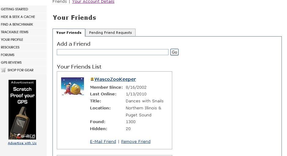
Just thought I'd throw another screen shot in here to validate other folks' claims that their "Friends" page is messed up. What's wrong with this page? Besides Slimy being my Friend, I mean...
Looking over this thread, I have counted ONE person who likes the white space to...oh, I don't know, a hundred maybe? who HATE it. It makes users scroll unnecessarily. It prints out the same way it looks on the page and uses twice as much paper - don't make me go all environmental on you! And any editor who employed it in today's world would be out of a job faster than he could say "spit." Would YOU read a magazine if you had to turn pages every few words?
Let me put it in very simple terms for the Groundspeak Team:
DITCH THE WHITE SPACE!
IT'S BAD DESIGN!
My friends page has a big blank spot...

My screen resolution is 1680 X 1050
-Nathan
I have noted the same problem... along with the # of finds / hides displayed not agreeing to what is actual.
-
Your Friends is not showing the correct number of hides for a few geocachers in my list. Presume this is either broken or the list is not being refreshed each time one browses to this section of their profile.
-
It's really simple to send out an Email to everyone (like the weekly one) to let everyone know the site will be down for maintenance.
Of course most companies run secondary servers so they just swap servers when they make changes.
This would make sense as I doubt there were any major database schema upgrades... use the same databases and servers even if you use load balancing. Apache/Tomcat/JBoss can run on custom ports and still have a Virtual IP Address listening on a standard port. All you need to do is change the Pool with the server nodes. This is how every company with production systems handles such upgrades. Takes like 2 minutes to make the switch... issues, just switch back. Also, any reason why more of the geocaching community was not invited to beta test? This would have I am sure prevented many Day 2 issues.
-
Ramapo Valley County Reservation
Notes: Really nice 8.8 mile loop hike which allows you to bag the new caches recently put out by weathernowcast and wjgrun. Parking is at the main lot off Ramapo Valley Road (Route 202). The following are the trails which were taken: Silver Trail -> Schuber Trail (Orange) -> Red-Silver Trail -> Shore Trail (Blue) -> Cannonball Trail (Red) -> Bushwhack (PK's favorite type of trail) -> White Trail -> Hoeferlin Trail (Yellow) -> Shore Trail (Blue) -> Bushwhack -> Pipeline -> Halifax Trail (Green) -> Silver Trail. Total hike in the snow should take around 6 hours if you take your time.
-
My opinion is that it is a resource problem at Groundspeak and the only thing deleting cookies, rebooting, or any other "fix" does is make your retry at a later point when GS may not be so busy.
Um, seeing as cleaing your session cookie fixes the problem instantly (without even restarting browser), this is clearly wrong.
Clearing the session cookies will reset any the temporary state (on the server) the site stores about you, since you are starting a new session. Waitiing until that session expires would have the same effect. As a web developer I doubt it's related to 'business', though possibly the initial condition is triggered by that.
Wrong, the time he took to clear his cookies probably gave enough time for him to land on another server at gc. Remember, there is more than one front end server, and if this is happening on one server only, then whatever method they are using to load balance (it appears to be round robin dns) could very well be enough of a pause to force him to a new server.
A 500 error is ALWAYS something on the web server, if clearing cookies fixes it, then in most cases something underlying is what really fixed it (like moving to a new server) OR some really bad code that allows a bad cookie to make it error out (which should never happen, its an open door to a dos attack).
Official definition (as defined by w3.org):
500 Internal Server Error
The server encountered an unexpected condition which prevented it from fulfilling the request.
Probably using session persistence on the load balanced server pool. Would presume one of the servers needs to have IIS / Apache / Tomcat restarted. Simple HTTP monitors would not suffice if the server is still up and the load balancer keeps servicing requests to it.
-
Beer hikers the bane of the outdoors.
Make it an event and perhaps we can talk.

Should pick a weekend then and head up to Harriman. Alternatively, High Point is also a good choice as there are several good quality shelters not to far from one another and its all self registration, etc. Thoughts / suggestions?
-
Best idea I have heard in a long time and it wouldnt be too hard to implement.
-
Just got back from spending the holidays (ie, New Years) in Florida. Would highly recommend the following canoe/paddle and hiking loops if anyone is fortunate to escape the cold.
10,000 Islands Section of Everglades National Park
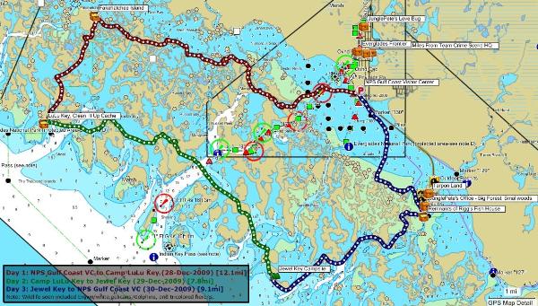
Notes: We rented canoes from Ivey House in Everglades City and put in at Gulf Coast Visitor Center. (Rental cost was approximately 90$ for 3 days with watercraft transport included.) Ended up camping at Camp LuLu (just outside of the NPS land w/o any permits/reservation requirements) and Jewel Key (permit required). In total we did 29.0 miles and found 3 caches including one rated 5/5. Saw lots of waterfowl but unfortunately did not see any gators.
Weeki Watchee Preserve
Day 1
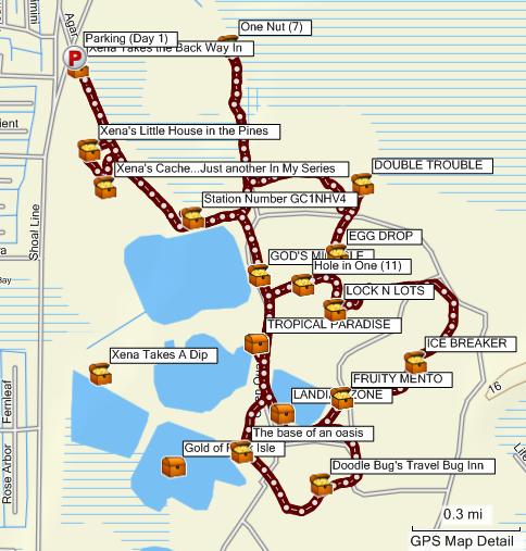
Notes: Ended up hiking only about 8.4 miles along the major trails and finding 14 caches. Really pleasant walking with many of the trails used by mountain bikers. The area used to be mined for limestone and there are many filled in lakes which are quite beautiful. It is possible to kayak in these waters with a short portage.
Day 2
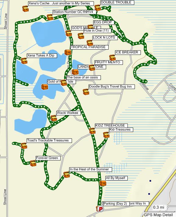
Notes: Ended up hiking 13.6 miles along many varied trails and finding 8 caches. Highly recommend the Multi "In the Heat of the Summer" which takes you into the lesser traveled portion of the preserve where the chances of spotting wildlife are higher. Supposedly you can find gators and the Florida black bear in this park. We, however, only was waterfowl.
-
Been having this issue on mixed environments both at work and home throughout the day...
Work - Proxied connection (bluecoats) with IE 6 / FF Portable 3.5.
Home - Non-proxied connection with FF 3.5.6.
Error appears to happen when I am viewing caches in google maps view (ie, http://www.geocaching.com/map/default.aspx) and selecting caches to open up a new window to add a log. After submitting one log and going to the other tab to select the next cache I receive this error. Most recently happened at home around 1:30 EST and still persisting.
I was able to recover by terminating my session via http://www.geocaching.com/login/default.aspx?RESET=Y and then re-logging.
-
Been having this issue on mixed environments both at work and home throughout the day...
Work - Proxied connection (bluecoats) with IE 6 / FF Portable 3.5.
Home - Non-proxied connection with FF 3.5.6.
Error appears to happen when I am viewing caches in google maps view (ie, http://www.geocaching.com/map/default.aspx) and selecting caches to open up a new window to add a log. After submitting one log and going to the other tab to select the next cache I receive this error. Most recently happened at home around 1:30 EST and still persisting.
-
looks interesting, although 'good' beer seems pretty relative depending on who you talk to. I once saw different liquors in Gu-style packets that is far more weight-efficient than this, however.
Personally, cant wait to lug a bomber of cadillac mnt stout from bar barbor maine to Kathadin ME
-
I can't imagine it tasting very good.
I'll stick with my favorite backpacking beer:

1 16 oz can per night and one in the car on ice for the end of the trip.
I remember drinking this stuff by the 5 Litter mini keg in college... not bad for what it is. You want to lug one with me to a Harriman shelter come spring?
-
Another great hike in Harriman State Park allowing for exploring Silvermine Lake, Cranberry Hill, Long Mountain, and Summer Hill over 13.1 miles. Did this hike with wjgrun in the snow
We ended up finding 12 caches and there is a possibility for many more with a few extra hours of sunlight.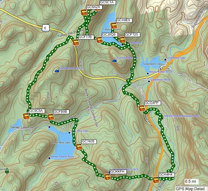
In general summary, we parked at the Anthony Wayne Recreation Area parking lot and took the following trails: Ski Trail -> Appalachian Trail -> Silvermine Road -> Seven Lakes Drive -> Nawahunta Fire Road -> Long Path -> Popolopen Gorge (PG) -> Turkey Hill Road -> 1779 Trail -> Anthony Wayne Trail.
Will be planning a hike around Bear Mountain soon and will plan on packing some coffee to french press at the top
-
Another good loop is the new Mine Trail/Highlands Trail loop in Norvin Green. It's only a 3.5 mile hike but the new trails are outstanding
Will put that on my list for the Spring when GCHTXP is re-enabled
Unless the CO gives me permission to go in there to wake up some of the hibernating mammals No cache in there as of now, and it may or may not be enabled come spring. It depends on whether or not the state allows people in the mine. It was closed all summer because of White Nose Syndrome.
Poor bats :[ Hope the ones in Hibernia are doing OK.. saw lots of them when I was there in early fall last year.
More information on WNS here.
-
Happen to be in Delaware for the Thanksgiving Holiday and attempted the Geotrail without much success. Two of the caches we tried near Wilmington were closed due to the holidays since the land is owned by Dupont. The guards to the park had no idea about the Geotrail either... quite odd. Like the AGT Geotrail much better as most (if not all) caches were accessible 24/7 and without the need to pay any admission fees, etc. Starting working on one of the Maryland series while in the area instead.
FWIW, I did all of the Delaware Geotrails and there was not a single one I had to pay money for. They were all free.
As for the AGT, I did a bunch that were closed at night; so not open 24/7.
For the AGT, think we noticed that there were at least 6 (bare minimal requirements) open at night for each county, ie, either easy roadsides or in WMA areas that were open at night. Delaware series is convenient when we are there visiting for Thanksgiving or Christmas but not so convenient as the private lands are closed for the Holidays :<
-
Another good loop is the new Mine Trail/Highlands Trail loop in Norvin Green. It's only a 3.5 mile hike but the new trails are outstanding
Will put that on my list for the Spring when GCHTXP is re-enabled
Unless the CO gives me permission to go in there to wake up some of the hibernating mammals 
-
Definitely doable... 2 months ago did El Capitan and Half Dome from the valley floor on back to back days with some heavy beverage consumption the night between. That was about 9000-1000K elevation gain over about 38 miles. Then again... I did do Mount Washington from Pinkham twice in one month so I would definitely recommend a good regime of heavy weekend hiking prior to your attempt.
Good luck!
-
Here is a nice 9.9 mile hike I did with ThirstyMick this past Saturday in Wawayanda State Park during the snow storm:
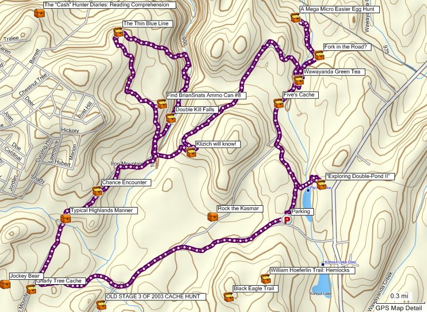
Notes:
- Typical Highlands Manner (GC1BYGM) was DNFed and has since been confirmed missing by the CO.
- Rock the Kasmar (GC1F2W4) was not possible on account of darkness and having to shovel out the car before the park closed at 6PM.
- A Bridge To Far (GCXDZ2) was not attempted as we were not aware of the time this archived cache is still there.
Thus, given better weather and the above notes its possible to bag 12 caches on this loop at least. (I am not counting any caches I had found on my previous visits to the park which the loop passes.)
-
Happen to be in Delaware for the Thanksgiving Holiday and attempted the Geotrail without much success. Two of the caches we tried near Wilmington were closed due to the holidays since the land is owned by Dupont. The guards to the park had no idea about the Geotrail either... quite odd. Like the AGT Geotrail much better as most (if not all) caches were accessible 24/7 and without the need to pay any admission fees, etc. Starting working on one of the Maryland series while in the area instead.
Ended up working on the Ranger Challenge in Maryland and had fun exploring the various parks and local brewpubs when the sun went down. Must say the caches in Prince George's County were generally much better than those in Montgomery County as they involved more bushwhacking / longer hikes, etc.
-
My current tent is the North Face Tadpole 23 (http://www.thenorthface.com/webapp/wcs/stores/servlet/ProductDisplay?productId=10429&storeId=207&langId=-1&catalogId=10201&parent_category_rn=11750) which I use for backpacking. Fits 2 people and is just under 5 pounds. Compression straps (3) are built into the sack so I definitely roll it and throw in other stuff such as shirts, socks, etc. Put it vertically into the backpacking pack and it only takes up 1/2 of the vertical space so I use the other side for packing in the Jetboil, food, and rain gear. Works well, however, thinking of getting an ultralight Bivy for when I am hiking by myself in the Catskills, Adirondacks, etc as 5 lbs is a good deal of weight when bushwhacking to bag peaks.


Groundspeak stores the password unencrypted in the database?
in Website
Posted
Even if the password data was encrypted in the database, I presume the SMTP server would still send the password in plaintext over the Internet. Better approach may be a one time accessible URL to allow the password to be changed over an HTTPS connection. Does Groundspeak even provide HTTPS encryption for logins? If you are on the road and using someones wireless (like a hotel or starbucks hotspot, etc) its possible someone could be sniffing packets in promiscuous mode.