


polskikrol
-
Posts
294 -
Joined
-
Last visited
Posts posted by polskikrol
-
-
I am envious, I always wanted to go up one high peak, either in the Catskills or Adirondacks. I think I will do it this year---the operative word is ONE, and I will look for one that is not too difficult and has a nice view, I wll plan to do it in September. Thanks for the inspiration.
I would recommend Panther Mountain which is probably around 5mi round trip with lots of good views of Devils Path.
http://www.catskill-3500-club.org/catskill...er-mountain.htm
It is also in the middle of what may have been a meteorite impact crater site. Just check out wikipedia for more info. There is also an Earthcache regarding this.
I highly recommend Indian Head. There is a nice loop hike over it using the Jimmy Dolan Notch trail and the Devils Path with a couple of outstanding views.
. It is on the rugged side but if I can do it, anybody can..
A bit easier is Kaaterskill High Peak. Fantastic view from an unmarked trail on the south face. The Aircrash 1 and Aircrash 3 virts are along the way.
Blackhead is another good one. A not too long loop hike takes you over it and back to parking.
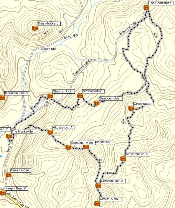
OK, having done Kaaterskill High Peak this weekend, must say this will give you the most bang for the buck. If you can handle 10.4 miles and 2680 feet elevation gain then the following can be done:
- Kaaterskill High Peak (awesome view to the south)
- Huckleberry Point (awesome view of the Devil's Path mountain range)
- 2 Air crash sites
- 6 Geocaches
Take a look at the following tracklog:
The following is the recommended route:
- Park at the official lot off Platt Clove Road. Sign is small and wooden, missed it on the first pass down the road.
- Take the snow mobile trail up and cut towards the 1st aircrash site when you see a cairn on the left hand side of the trail. This should only be a 600 feet bushwhack or so.
- Follow the circular snow mobile trail by the 1st aircrash site clockwise and cut right to the top of High Peak when you see a really huge cairn. This is the old blue-marked Twilight Park Trail and quite easy to follow to the summit.
- Arrive at Hurricane Ledge just before the final summit push. Great spot for a snack or just taking in some water.
- At the summit there are two trails looking north. Take the one to the right first to visit the 2nd air crash site.
- Take the trail to the left and head down the northern side of the mountain to eventually meet the snow mobile trail again. Follow the trail clockwise until you get back to the 1st air crash site and bushwhack back to the trail you started the day on.
- On your way down, take the Yellow Disk trail on your left towards Huckleberry Point. The elevation gain to the point is really negligible at this point. I hear there is a good camping spot near the stream your cross between hills.
- Just retrace your steps backward on the Yellow Disk trail to return back to the snow mobile trail and parking.
I will definitely be doing this hike again with ThirstyMick as well as the Hunter Loop via Diamond Notch Falls and visiting the various lean-tos and South West Hunter (nice bonus as it has a good unmarked trail to the summit with a trail register). That area was the highlight of my Devils Path traverse.
-
I am envious, I always wanted to go up one high peak, either in the Catskills or Adirondacks. I think I will do it this year---the operative word is ONE, and I will look for one that is not too difficult and has a nice view, I wll plan to do it in September. Thanks for the inspiration.
Well, it might be off-topic, since this is the Mid-Atlantic thread... But I would suggest my webcam cache on Mount Washington, New Hampshire. Took us two and a half days to hie there, but you could drive, or take the cog railway.
Two and half days from NJ or Pinkham Notch? The webcam is a great cache and have done it at least twice already

-
I recall a few years ago running into two guys who were hired by a group of Boy Scouts to shuttle their equipment and vehicle to the end of the trail. So I guess people exist who do that stuff. There might also be a bus that runs along 23.
Might want to check the ADK forums for options. They have a Catskills hiking forum where there might be people with specific knowledge that can help you. Or perhaps the Backpacker Northeast forum.
BTW a guy hiked the entire Devils Path last week in a little over 10 hours. Took me 3 days when I did it.
Natalie and I are still mulling over our options for Mem Day weekend. One of them is backpacking in the Catskills. If we decide on that then there is a slight chance we might be able to help you out.
Brian - Would be much appreciated if you end up deciding on the Catskills. I will check out the other options when I get home tonight.
I myself am planning on "taking it easy" over 3 days to allow time for bagging some nearby peaks off the Devils Path.. would be 9 planned in total.
-
Dont suppose anyone lives close to the Devils Path in the Catskills and would be kindly available to provide a shuttle from the trailhead on Plattekill Clove Mountain Road (Rt 16) to Spruceton (Rt 6)? Alternatively, any resources for finding a kind soul to provide a shuttle between those 2 points?
-
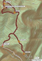
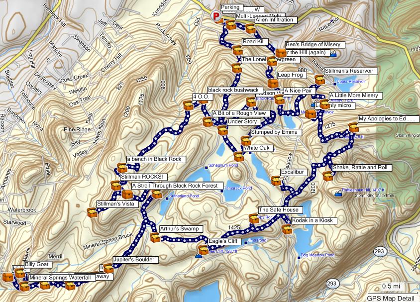
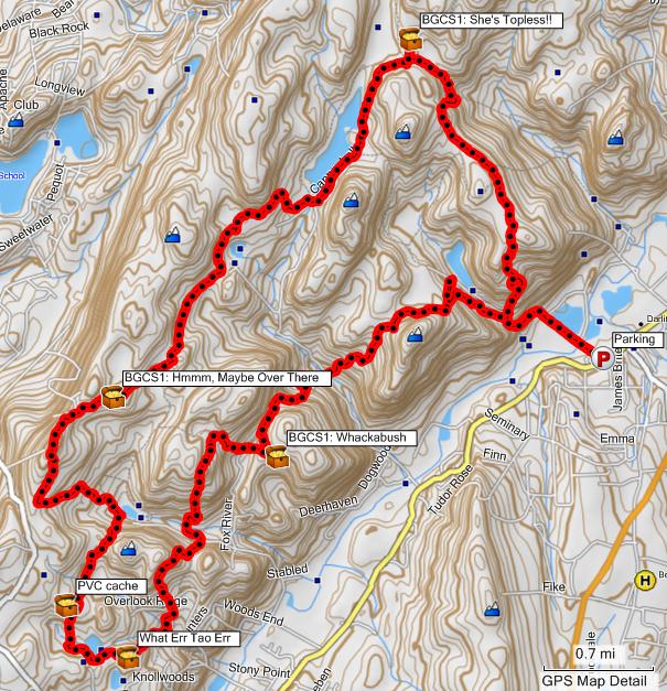
Black Rock Forest, NY
A nice 21.1 miles loop hike with 34 caches found along it. Long day starting at around 6AM and ending at around 8PM. However, well worth the effort due to waterfalls, summit views, swamps with boardwalks, etc.
-
Starting to get into hammock tenting and currently have an ENO System consisting of a SingleNest, DoubleNest, and Slap Strap Pro. Spent a night in the Catskills and it was a little chilly and had to put on extra socks, shirt, and sweatshirt to finally fall asleep. My sleeping bag is a North Face 20 or 30 degree mummy bag. Also have a bug net should it get bad however have no had issues yet.
What would be the recommendations for the following:
- Improving warmth? Invest in better sleeping bag? Get a blanket or something?
- What tarp is recommended? Looks like the ENO Sil Dry Fly is out of stock and speaking with the manufacturer they are redesigning it.
-
I am envious, I always wanted to go up one high peak, either in the Catskills or Adirondacks. I think I will do it this year---the operative word is ONE, and I will look for one that is not too difficult and has a nice view, I wll plan to do it in September. Thanks for the inspiration.
I would recommend Panther Mountain which is probably around 5mi round trip with lots of good views of Devils Path.
http://www.catskill-3500-club.org/catskill...er-mountain.htm
It is also in the middle of what may have been a meteorite impact crater site. Just check out wikipedia for more info. There is also an Earthcache regarding this.
-
Catskills Adventure
This past weekend had an epic 2 day weekend adventure culminating in the logging of Aircrash 4 (GCPY3E) by GPS Guy. Not recommended for non-seasoned hikers as this covered approximately 31.2 miles in the Catskills and ungodly elevation gain. As stated by GPS Guy on the cache page, nearby 3500+ peaks are doable and would make for a great weekend. Thus, the following were the 7 Catskills 3500 Central Region peaks I was able to summit on the loop hike (which did involve lots of bushwhacking):
Fir Mnt (3620ft) - 2010-05-15 1020
Big Indian Mnt (3700ft) - 2010-05-15 1144
Eagle Mnt (3600ft) - 2010-05-15 1329
Balsam Mnt (3600ft) - 2010-05-15 1540
Balsam Lake Mnt (3723ft) - 2010-05-16 1207
Graham Mnt (3868ft) - 2010-05-16 1347
Doubletop Mnt (3869ft) - 2010-05-16 1604
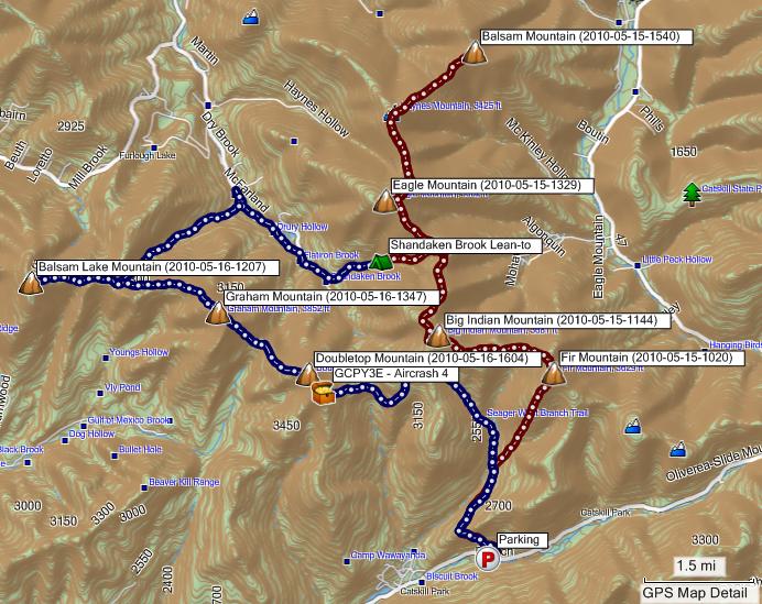
Looking at the tracklog, Day 1 (15.2mi) is in red and Day 2 (16.0mi) is in blue.
There was quite a bit of bushwhacking during the weekend which entailed following several river beds to gain access to the other side of the valley and subsequently a new ridge of mountains. Camped near the Shandaken Brook Lean-to in my hammock which was quite comfortable (once I put on extra socks and shirt) and relaxing (hanging about 10 feet from the therapeutic stream). In total I went through 8 liters of water and sustained only on pretzel sticks and gorp as I wanted to travel light without my camping stove. Finding Aircrash 4 was the icing on the cake following this awesome trekking adventure. Definitely one of the more challenging caches I have found (which I do appreciate).
WARNING: Do not attempt this loop hike unless you are well prepared, seasoned, and know what you are doing!
-
If you are available any time during the weekday after 5PM I usually hike around in the Palisades and would be more than happy to accompany on a loop hike for some caches.
-
If you go to Englishtown auctions near Marlboro, NJ there is an army surplus vendor that sells them for 5$ each. Alternatively, you can pick them up from the store/warehouse in Princeton, NJ. Contact me directly and I can provide the information regarding this source.
-
Harriman State Park
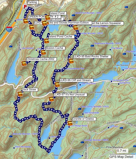
Notes: Parked at Elk Pen and ended up hiking 18.4 miles in just under 11 hours via the following trails: Appalachian Trail -> Arden-Surebridge -> Lichen -> Ramapo-Dunderberg -> Victory -> Unnamed Trails (Lake Sebago North/Western Shoreline) -> Triangle -> White Bar -> Island Pond Road -> Arden-Surebridge. If you are so inclined, there are 14 caches to find along this route and it is not very strenuous. On the way you pass 3 Shelters (Bald Rocks, Tom Jones, Unnamed Shelter (Route 106/White Bar)) - thus this can be turned into a 2 day weekend trip. Had lots of fun on this one.
-
5.9 mile bushwhack (there were woods roads around, but most of my trek seemed to be off-road) around Tranquility Ridge County Park to pick up weathernowcast's 10 (PM) cloud series caches (plus two others).
You avoided all of the caches placed my ThirstyMick, slukster, and myself to the north/west :[ Would suggest those before it gets too hot outside otherwise you may run out of water packing all of those small bottles

-
Wish I saw this post earlier
 Just finished the NJ Section of the AT from Route 17A (NY) to Route 80 (PA) over the course of 6 days. Quite an experience and I am sure I passed many caches. However, given that it rained 3/6 days, I probably would have forgone the caching anyways. Hope you enjoyed the trip!
 -
I remember when this thread was about Great Ny/Nj loop hikes, but it seems to have morphed into a thread about 'extreme' hikes. Should we start another thread for hikes under 12 miles long?

Everyone caches for different reasons - I myself enjoy a nice long hike to challenge myself and get my mind off from work while hiking for a goal, geocaches in this case. To each his own.
If you examine most of the tracklogs I post, it is possible to omit a few loops and thereby make the hike shorter. Also, it is possible to use cutover trails to reduce the size of the loops. While my hikes may be lengthy and not appealing to everyone, it may give a conceptual idea to how much area can be covered in a certain amount of miles. Most NJ/NY trail maps do not provide distances between points along a trail (trail miles) and as such what you think is a 5 miles hike may actually be a 9 mile hike. Just because I did it, does not mean others should. However, I expect my tracklogs could give others and idea of what is possible any they can adjust their trips accordingly.
If you want post a hike under 12 miles long, please be my guest. At least I am posting some tracklogs of what Northern NJ / Southern NY has to over for those willing to put in the miles.
-
Anyone have any recommendations on wool socks for the winter cold and wetness? Also, any recommendations on where one can get these on the cheap? I could care less about designs on them, etc and am trying to find a way to get these in bulk.
-
This loop hike I think should be called "Tour de Ramapo". Nice grueling 16.1 mile hike in just under 7 hours to grab wjgrun's new caches. Will be planning on something similar but for Ringwood.
Disclaimer: Would not recommend the above unless you have plenty of water, are in good shape, and somewhat insane

-
For President's Day ended up hiking 13.8 miles over the course of 12.5 hours with wjgrun in Abram S. Hewitt State Forest.
The tracklog just shows the caches which were new for me and we visited about 8 more in addition which I had found previously. Really nice part of Northern NJ.
-
Woodbine, NJ 8 inches.
-
Looks like Delorme Earthmate is going to come with SPOT builtin. Amozon Linky You may want to wait for this before blowing all that money

-
Done
http://www.youtube.com/watch?v=KyzcRyKFmQQ
Hope you like it
Thank you to everyone who sent me photos. I think I got a few in from all of the submissions.
Really nice compilation! Finally got a chance to see it as we block youtube at work and my workstation does not have sound :[ Enjoyed the slideshow with some Troegs Unfiltered Wheat and raised by bottle to another great 10 years - cheers!
-
eTrex Legend: $100
Ball point pen: $2
Sensible walking shoes: $75
Having cover blown by google Earth: priceless
I would upmod this however the site provides no such functionality

-
.png) 1
1
-
-
I have never had any problems with going directly to the Echo Lake office and getting a permit from the nice people there.
Presume you dont work Monday - Friday?
-
Looks like obtaining permits for hiking in the Newark Watershed is nearly impossible. Called the The Newark Watershed Conservation & Development Corporation (NWCDC) Echo Lake Office this morning and found out the following:
- They are no longer open on Weekends during late fall, winter, early spring. This is despite their website mentioning otherwise. http://www.newarkwatershed.com/html/contact.html
- Apparently they also do not do mail order unless you are only a member of the NYNJTC and are one of their trail maintainers. I advised that this is not what the following link says: http://www.nynjtc.org/trails/peqpermit.html . They will not accept mail in of photocopies of AMC or NYNJTC membership cards as you must be one of their trail maintainers.
- When I asked for a contact to escalate these issues, I was rudely hung up on by the lady at the Echo Lake Office.
- The only way to receive a permit is to show up in the office, during their weekday hours, and pick one up. Love the discrimination against people that actually work for a living. Must be nice to have an office job and not to be bothered by weekend hikers / weekday workers coming in.
- Sent an email to info@newarkwatershed.com and it was never answered or acknowledged.
Thus, I am not sure how many geocachers are legitimately logging these NWCDC area caches or how they are obtaining permits. If there is something I am missing, please enlighten me.
-
Don't feed the troll.
excuse me?
You have brought is much enjoyment on the trails. thank you.
Would that be English or some odd dialect ? Perhaps, "You have brought us much enjoyment on the trails."
 Just finished the NJ Section of the AT from Route 17A (NY) to Route 80 (PA) over the course of 6 days. Quite an experience and I am sure I passed many caches. However, given that it rained 3/6 days, I probably would have forgone the caching anyways. Hope you enjoyed the trip!

.png)
Catskills Devils Path (Memorial Day Weekend)
in Northeast
Posted
BrianSnat ended up helping me out on this one - many thanks!
Ended up completing the Devils Path and cumulatively hiking 44+ miles with nearly 15,000 feet elevation gain. In total, bagged 9 of the Catskill 3500 peaks including Rusk. Now still have 10 more to go to do all 35
If anyone is interested in doing the Devils Path in the winter with some snow shoeing / trekking, let me know.