

ddnutzy
-
Posts
153 -
Joined
-
Last visited
Everything posted by ddnutzy
-
The problem seems to be resolved. I sent destroyed email to Deb and I think it got to her. I don't know what happened earlier but I think everything is alright now.
-
Both of the emails I sent were refused and returned to me as if Deb was no longer there. I just sent another email to see if it happens again.
-
-
Earlier this week I tried to email Deb with two destroyed stations and each time I got a email return message stating that this was a permanent situation or something like that. Any one else have the same problem? Dave
-
Your Best/Favorite Benchmarking pictures.
ddnutzy replied to 2oldfarts (the rockhounders)'s topic in Benchmarking
IMG_0724 -
Your Best/Favorite Benchmarking pictures.
ddnutzy replied to 2oldfarts (the rockhounders)'s topic in Benchmarking
This is a picture of PG1684 (Camels Hump Reset 2 RM1) looking north towards Mt. Mansfield which is the highest mountain in Vermont. Camels Hump is the third highest. The haze is smoke from forest fires in Canada. -
OD1328 in Vermont. I got this while hiking the Vermont Long trail. I forgot to bring the sheets so this one in the only one I found The station is in the center of the picture.
-
I've found quite a few BM's in the snow. I snowshoe in with my pack and a metal detector. If I can find a good take off point to measure from I do that then I clean off the snow and use the metal detector until I get a signal and go from there. Some of my finds are mz 1532, mz1533, mz1534, my3009 and my6397. Some off them had up to 18 inches of snow on them. Dave
-
Richard, I was impressed when we went out earlier in the year but now I'm amazed at what you do when searching for old benchmarks. This station is without a doubt the most intriguing benchmark that I've heard about. Keep up the interesting work. It's well worth reading about. Dave
-
Since they each have different coordinates they can't be on the same disk. Skelton is at N46 30.318 W092 40.467 and 0980 is at N46 30.267 W092 40.483 .1 miles different. I have no idea what the problem was when they set them but I don't think that they are at the same location. I'd check the other coords and see what's there. Dave
-
The Eastern Oblique Arc cross Massachusetts
ddnutzy replied to Papa-Bear-NYC's topic in Benchmarking
I've found quite a few benchmarks on Mountain tops around New England using the USGS paper description the box,highlighters.compass,100m tape and a metal detector plus the other tools in my bag.My only companions on these trips were Wildbird, probably 20 or so finds and Blackstone Val with 7 or so. All the rest were by myself. Last weekend I had the privilege of spending two days looking for benchmarks with Papa Bear. The organization was amazing. All the stations and Rm's were laid out on Google Earth with the azimuths and distances in both feet and meters. He had all the USGS descriptions and the maps in the order that we were going to look for them. He also had Mapquest directions, or something like that from point to point so that it would be easy to get from one station to another. All I can say is that it was a enjoyable weekend of benchmarking finding stations that were used in the surveying of Massachusetts in the 1800's. There's no way that I would ever have figured out how to do what Papa Bear did for that weekend. Dave -
You know your a benchmarker when you drive 226 miles one way to find two benchmarks ( PF1173 and PF1171) and do the climb up Caribow Mt. when there is lightning to the north, and it's coming south. It was a 3 mile climb up the mountain and it rained most of the way up. At least I didn't go up Speckled Mt. to find that one. The storm really came along with high winds, thunder and lightning. I did go back at a later date and got PF1171.
-
Here's a list of the older BM's that I've found over the years. I've found over 30 from the 1800's. Most of them are FTF. MZ1504 1832 oldest in Ma. MZ1615 1832 MZ1702 1832 MY3617 1834 oldest in RI. MY3611 1834 LW5088 1834 MY2666 1834 oldest in NH MZ1913 1836 oldest in VT OC2210 1842 oldest in ME Dave
-
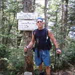
A USGS BM on Mt Liberty in NH. I think,but I'm not sure that the drillhole in the foreground is a RM. The figure in the background near the station is my hiking partner, Mr. Brigham.
-
It doesn't look like there is to much deterioration of the concrete because it looks like the disk is at the same elevation as the area where the chiseled square is supposed to be located. It could be under the leaves on the edge of the concrete. That looks like it's about 6 inches further north of the tracks. Dave
-
RI - CT BORDER ... any one want to team up?
ddnutzy replied to bullionhunter's topic in Benchmarking
Hi, I'm up for a little benchmarking trip along to border. I've found a few in that area but there's got to be some new one's out there that I didn't find. Dave -
A 2003 Subaru Baja known as the Bajamobil is my ride of choice. I've taken it on old loggin roads,up mountains on said roads, through deep mud and over lots of rocks and ledges while looking for old bm's. The picture is on the way back from MZ1700 (High ridge) on 1-4-05.
-
USGS is interested in getting recovery reports
ddnutzy replied to Black Dog Trackers's topic in Benchmarking
John, I have numerous map programs but the one that I use the most is Terrain Navigator Pro from Maptech I also use Terrain navigator. All of N.E. for the pro is $299.00 and the Navigator is $99.00 for N.E. The detail and ease of use is worth the cost. With the pro the NGS bm's are on the map which makes it easy to find them on any quad. Dave -
Thanks to everyone who helped me on this subject. I have waymarked the disk under Mt Liberty. Thanks again, Dave
-
Yesterday I was hiking on Mt Liberty where I found a BM disk marked US Geological Survey, elevation, ET10DA, 1964. When I got home I couldn't find it in the Geocaching or Ngs database. I did a radial search with no results. The elevation is 4459 feet and the coordinates are N44 06 57.62 W 071 38 33.01. I need help finding out what the pid of the station is. Thanks, Dave
-
Thanks for the reply. I do not have either of those programs. I have Map Send topo that came with my megellan. Guess I will find out . Thanks again I think that the mapsend program will work like the mapsouce
-
Keystone, Thanks for the info. The cache is now enabled wjth the new coordinates. Thanks again, Dave
-
I sent in one reply but it doesn't seem to be there. I use a Garmin c330 to find benchmarks. I mark the waypoints on my Mapsource Topo or my Maptech program and dowload them to my c330. It get me close by road then I use my Garmin 60csx for the rest of the trip. Dave
-
I moved one of my caches (GCQRJQ) about 90-100 feet to the south of it's previous location and tried to change to coords on the file page. I could not change the original coords on the file. I emailed Groundspeak but did not get a reply. Does anyone know how to change the coordinates? Thanks, Dave
-
Benchmark Picture Contest 2007 - Part 2
ddnutzy replied to Black Dog Trackers's topic in Benchmarking
OC1354 RM1 which I think is different.