


cliff_hanger
-
Posts
338 -
Joined
-
Last visited
Posts posted by cliff_hanger
-
-
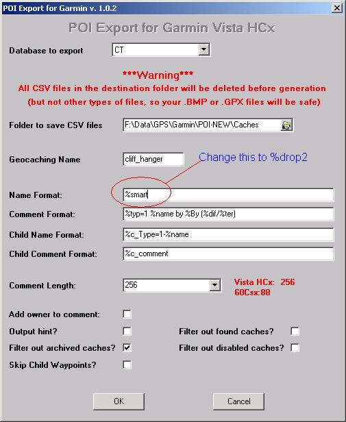
Does anyone know how to mod the GSAK POI macro to use %drop2 rather than %smart name? I prefer GC codes to names.
Try this: on POI Export dialog box, change Name Format from %smart to %drop2
-
Sorry I left you hanging. I was out rock climbing today. Did 5 routes, self belayed solo. Not bad for a 54 year old dude, eh?
I'm more interested in managing multiple files (POIs) for the purpose of flexibility when traveling
I'm not sure why, since the Vista will manage literally thousands of POIs. It just displays the ones that are closest to you. As I said, if the name of the bitmap symbol (ie Traditional) matches the name of the gpx file and is in the same folder as the gpx file, then the correct bitmap is assigned to the POI when you run POI Loader.
However, there is no need to run separate gpx files for each type of cache. The beauty of the POI macro is that it handles all of that for you. It looks like Miragee runs one export for each type of cache. I run ONE macro for all of Connecticut. The macro sends 18 different csv files (instead of gpx) to my POI-NEW > Caches folder. The names of these cvs files match the bitmaps in that folder. (Note that capital and lower case naming is important!) Hence, when the POI loader does it's thing, it "attaches" the correct bitmap to each POI. Make sure you download the bitmaps from here
Since I point the POI loader to the "root" (POI-NEW instead of Caches) it creates one non-selectable database named "Caches". All the different POIs are in that one database with correctly assigned symbols. If I was to point the POI Loader to the "Caches" sub-folder, it would still create one file for transfer to the Vista. HOWEVER, within that one file would be 18 selectable "databases" such as: multi, found, traditional etc. And, I believe, you can only select one at a time - not sure, though. They might be additive.
So far, I managed to create separate databases, but the information is currently useless, until I can figure out how to see all the caches in an area.
You don't have to switch from one database to another. (Unless you have a reason that I can't see) That idea is a holdover from the way your Merigold worked. I fell into the same trap. Trust me, put all the POIs into one file by pointing the POI Loader to the "POI-NEW" root.
When I cache, I like to drive and find caches along the way, by making quick glances at the GPS map. Having to continually go through the "find nearby POIs" procedure just won't cut it

Ahhhhh....... You don't have to "find nearby POIs" procedure. You want to see them on your map.
From your map page, click the page button. Do Setup Map > Points and then set Map Point and User Waypoint to something like 500 feet. The points you want will then show up on your map when you are zoomed down to 500 feet. And it will show all types with the correct symbol if you followed the procedure I wrote above.
-
I don't use the Macro. I just modify the .gpx Export, .pdb Export, or "Send to GPS" dialogue boxes to contain the "smart name" information I want.
Doesn't that send the info to the GPSr as "waypoints"? Maybe I misunderstood. I thought the OP was asking about POIs. I think we are limited to 1000 waypoints but POIs are limited only by the memory of the SD card.
I use the "smart name" codes for the Waypoint names, but include the "GC Code" in the POI Export, in case I need it.
I don't follow. Do you use the Garmin POI Loader at all? Or are you only loading "waypoints" & "geocaches" to your GPSr?
-
Thanks Cliff Hangar, that is exactly what I was looking for !
So far I installed the GSAK Macro, created a "Garmin/POI folder," and installed the Garmin POI Downloader.
I opened GSAK, ran the macro, and exported the files from the database I was using into the POI folder. I was left with multiple different sets of POIs.
I then used Garmin's POI Downloader to send the POIs to my GPS.
I'm assuming I can send the multiple POI files to my GPS if I download GPSBabel, then stitch the files into a single output file. Is this the procedure you use?
I use GSAK, POI Macro, POI Loader. GPSBabel would probably do it since that is the translation engine behind GSAK. But, I don't know how to do it with just GPSBabel
I should point out that my current PQs include Traditional caches, Multis, Earthcaches, and Virtuals as one file. I'm assuming that I need to create PQs for different geocaches instead?
No, not if you use the POI macro. The macro will sort them out for you. Did you d/l the custom icons?
I followed your lead, and created a POI-NEW folder, and then created a Caches subfolder. I'm still playing with it, but have not figured out how to make this a single file when I open the POI screen on my GPS.
I think it depends on WHERE you point the POI Loader to read from. Use the "Please Select the directory where the data files can be found" and browse as follows: Try it once pointing to your "POI-NEW" and see what happens. Check it out on your GPS. Then try it pointing to your "Caches" subfolder to see the difference.
Read carefully my last post in this thread. Especially the numbered items
"Here's a folder structure with "Bill's POI" as a main folder, "Caches" as a sub-folder and some individual files:
<Bill's POI>
..<Caches>
......multi.bmp
......multi.gpx
......Trad.bmp
......Trad.gpx
......owned.bmp
......owned.gpx
4) Running POI loader and pointing it to <Bill's POI> folder will create one database named "Caches". It will actually be named "poi.gpi" but will show up in your GPSr as "Caches" database. Multi caches will have the multi symbol, Trad caches will have the Trad symbol, etc.
5) Running POI loader and pointing it to the <Caches> folder will create 3 different databases: Multi, Trad and Owned. Each will use the correct symbol. Multi caches will have the multi symbol, Trad caches will have the Trad symbol, etc. You can load them individually by "select database" on your GPSr. The strange thing is that they will also show up as a single file named "poi.gpi" but will show up in your GPSr as selectable Multi, Trad and Owned databases. "
But, read the whole thread. Let me know if you need further explanation. It took me a bunch of tries to figure it out.
-
Please bear with me, i'm a four year Magellan Meridian Gold user who received my new Garmin today.
With my old Merigold, I could export multiple files or databases filled with waypoints for different areas. When I entered a different area, I would simply delete all waypoints, then load the new area waypoints.
Is a similar function possible using the Vista HCx? I'm exporting the waypoints via GSAK, using the "send to GPS command." From what i've read, some Garmin users are opting to download geocaches as POIs, to organize, label, etc.
Can some one point me to a thread or website showing how this is done.
Thanks in advance!
I went the exact same route as you: Merigold to Vista HCx. (Actually love them both. But they do work very differently)
I currently use Geocaching Swiss Army Knife (GSAK), the POI macro for GSAK and the POI loader from Garmin. I download PQs for the whole state and import the 3000+ caches into my Vista in just minutes.
Here is a thread about how learning about POIs evolved for me after I bought a Vista HCx. I stumbled around a bit by experimenting but learned quite a lot.
Also, this thread about "Silly Garmin POI Tricks" may help you
-
Might you consider two smaller (medium sized) tents?
Dunno how big your kids are but, as they grow, some privacy for mom and dad could be welcome. If you ever go without the kids, a smaller tent might be just the ticket. And, sometimes it's easier to fit two smaller tents on a campsite where one big tent seems to find all the rocks and roots.
For family camping, I currently have a Eureka Sunrise 10. It's serviceable with plenty of room and good ventilation. Only used it in one torrential downpour with high winds and it stayed dry inside. The fly has plenty of additional tiedowns. Tall enough that I (6'2") can stand up in it. Supposedly the 10 x 10 will sleep 5 but I wouldn't count on it.
Since our son isn't interested in camping anymore, it's a bit much for just the wife and I.
-
Hi--My wife recently got a Garmin Vista HCx, and the wants to change the 'Find Geocache' list to show names, rather than IDs. How does one do that? I know you can use Spinner to combine names and IDs, but I also recall that the Vista has a setting that will change what's displayed. Thanks.
Well, I import them as POIs and they show up as names instead of GC numbers.
Looking at geocaches, unlike Cachemate, I don't see any place to toggle names/numbers. So, I think it goes back to the selection you make when loading them into your GPSr to begin with.
Some more information would be helpful.
How are you getting the cache information? As a pocket query? As .loc file or .gpx file?
How are you importing the geocaches into your Vista HCx now? GSAK? EasyGPS? Mapsource? Send to Garmin?
-
Acetone from Home Depot removes the yellow marking in seconds. It also "dulls" the green paint but does not remove it. Just pour a little acetone on an old rag.
I started repainting them but now I just rub off the letters and leave them green. Except, if they're going inside some place dark, I'll paint them flat black.
-
Also, quick question, we got the same unit, eTrex Vista HCx. We bought a 2GB micro sd card but it doesn't appear to "lock" in. When I push it down into the slot, it clicks and stays in but doesn't "lock", i.e. I can pull it right out (without push-clicking it out). Does yours do this? The problem is that it's not making good contact and doesn't see the card. I had to anchor it down with packing tape in order to get it to see the card so I can load my maps. I have a replacement already on the way but just wanted to ask another HCx user on how the card is locking in place for them.
My Vista HCx has exact same behavior with the micro card except it makes good contact. It really doesn't "lock" in place, but stays detented in the down position. Usually, I push-click it out.
Glad that you have a replacement coming
-
My winter bag is a goose down North Face "North Col"
Something else to consider when sizing a winter mummy is where do you keep your boots?
We've been winter camping the White Mountains of New Hampshire when it was so cold we put our boots in a plastic bag and kept them inside the sleeping bag overnight. Else, they were frozen in the AM and difficult to put on.
We've also put boiling water in 1 qt naglene bottles and snuggled next to them overnight. Just don't mix it up with your pee bottle.

You might also consider a Vapor Barrier Liner for the inside of your bag. Some folks don't like them because the think there is too much humidity. But my experience has been that you reach an equilibrium inside the VBL at some point - and your bag stays dry. The VBL, mummy bag, closed cell pad and an overshell make a great winter bivvy option.
-
Anybody have any experience with the North Face Rock 32 or Marmot Limelight?
Added links
-
another paperless caching tutorial in WIKI form
-
ok..but Vista /GPSmap is powered by two AA batteries- total 3 V, and most of the third-party cables come with USB come with 4,2- 5V output, /dont know Amper value/ so it makes me uncertain whether it could harm the unit or not.
Since original cabel is bloody expensive here in EU, Im looking for an equivalent substitution, cheaper one which could work as one by Garmin
Since USB standard is 5 volts, don't you think that Garmin put a voltage regulator circuit inside the GPSr between the mini USB port and the internal electronics? Or that the GPSr is designed to operate within the available voltage range of battery power to standard USB power?
I use a generic 12v cigarette lighter to USB converter plug. USB output is 5v because there's a voltage regulator built into the cigarette lighter converter plug. Else, it would not meet the USB standard. I use the cable that came with my Vista HCx OR the cable that came with my Cannon A620 camera. No difference. There is no attenuator built into the USB cable, so a generic cable would work just as well.
Question was previously asked in this thread
-
Is there a simple way to load POI or geocaches on a SD card instead of the GPSr? Sorry, I should have mentioned that I have a card reader and that what I would like to do is be able to load the geocaches from Geocache.com to my sd card. I am a premium member so can get the pqs.
My reason for this, is that my PC w/Vista will not recognize my Magellan Explorist XL
I currently use Geocaching Swiss Army Knife (GSAK), the POI macro for GSAK and the POI loader from Garmin.
Here is a thread about how it evolved for me after I bought a Vista HCx
Since GSAK uses the GPSBabel shareware as the translation engine under the hood, you may be able to convert the gpx files from your pocket query into a file that you load to your GPSr via card reader. I used to do that with my Merigold.
Also, this thread may help you
******
Edit, OK I should have seen that you have an Explorist. Try GPSBabel and convert the .gpx file from your PQ to "Magellan SD files (as for eXplorist)" - Sorry about that. Since sooooo many folks here use Garmins........ Well, I should just read better.
-
when i download geocache from new-brunswick, canada,into my GPS(colorado 300), i can track stuff, view description and ect.
is it possible to put it on my mapsource in my PC from my GPS after i found them, also, is there a way to have all the new-brunswick geocache in my GPS without tranfer them 1 by 1 and also have all of them into my pc so i can plan my trip.
any answer would really help me cause i been trying to figure this out, no luck so far
As Miragee mentioned, you could use Geocaching Swiss Army Knife (GSAK). But, GSAK uses GPSBabel as the translation engine "under the hood". GPSBabel is shareware, but Mr. Lipe accepts donations.
So as Miragee mentioned, you could get a group of 500 waypoints as a pocket query and use GPSBabel to translate the .gpx file into a Mapsource .gdb file
-
oops sorry
-
I'll take a shot at this. These numbers probably are NOT coordinates. There is no conversion.
After working for an RLS for a number of years, I agree that Cardinal Red is right on the money. The only thing I'm thinking is that the bearing is based on true north, not magnetic north. But, the OP definitely needs to find the coords of the starting point and then project waypoint(s) (using both magnetic N and true N just in case - although 54 feet is not gonna make too much difference) if he wants to use a GPS. Or he could buy a theodolite
-
I put the caches in the "Not Found" folder, but the default location is "Unfiled." If you forget and put the new ones in "Unfiled," you will end up with double entries.
On your PDA, you can prevent "duplicate" records in Cachemate by choosing "Merge import file records" and "Preserve old item category" under Cachemate > Option > Preferences
I create different databases in Cachemate so I can keep my Found caches in the Found database. I also have different databases for "Regions" here.
I do something similar. I have databases based on states: CT, MA, RI, VT, NH.
I have a "Found" database and a "Logged" database. The "Found" database keeps track of the caches I've found on a cache run. As I log them online, I move them from the "Found" into the "Logged" database. So, I guess the "Logged" database is really "Found and Logged"
-
My husband's always wanted to place a rock climbing cache, but we can't figure out how/where to place it and keep it hidden from all the rock climbers.
On a big belay ledge would be good, instead of in the middle of a route.
This one is actually signed by more rock climbers than geocachers.
-
Best to ask your reviewer before placing. I had one reviewer tell me the (s)he had leeway on the 528' guideline down to about 100'. BUT, that was for a rappelling cache relative to an existing regular cache. The logic being that there was no possible way that a cache where you had to rappel to a ledge on a 100' cliff could be confused with a cache at the top of the cliff.
Hope it works out for you. I, for one, am looking forward to your caches. Do you think they'll be up before May 22?
-
Seems that when the eTrexes, and the 60 series gained a memory card (MicroSD), these GPS units also lost the electronics that had the alarm clock capability, so that when these units are off, they are really off, with no standby capability, so that there is no alarm clock or barometer that runs, when turned off, like with the eTrex Vista Cx and the Map60CSx. I missed the alarm clock when I upgraded from the Map60C to the Map60Cx.
I don't think that software could compensate for the missing hardware in this case.
I dunno. I have alarm clock on my cell phone, PDA and wrist watch. I'd rather have longer battery life on my GPSr than have it on all the time to run the alarm clock and barometer.
-
Wow. After Merigee, did nobody read what the OP wrote?
"I was told my operating system wasnt compatible which I am running XP media center."
XP MCE is not XP-pro, not XP-home and not Vista. As Merigee correctly stated, There are KNOWN issues with Palm and XP Media Center Edition
http://forums.palm.com/palm/board/message?...essage.id=31768
http://forums.palmone.com/palm/board/messa...;query.id=75852
(There are known issues with Vista, too. But Palm has posted an updated patch that supposedly fixes the problem)
Wee Be Team, You may very well find that the best option is the one you already mentioned: "just insert the SD card into the pc and load the info then place in the Palm and completely skip the hot sync all together." The .pdb file generated by GSAK, or GPSBabel or CMConvert could be transferred to your SD card via card reader. The correct directory for cachemate would be "Palm > Launcher". My hotsync woks very well, but I actually prefer this method.
After putting the SD card back in your PDA, start Cachemate and, if you are not prompted, do Option > Rescan Memory Card. Close and then restart Cachemate and you will be prompted to select a database for your Cachemate files.
Please post back here if you find a different workaround so that others with the same conflict can resolve it.
-
The drivers are loaded. I have been able to load waypoints and POI's without problem. I can load my maps via mapsource (Canada Topo50). The device is recognized when I plug it into my computer. The interface is set to USB Mass Storage. Mapsource works fine. The only problem is the recognizing the SD card.
I tried installing the drivers on a different computer, with the same result.
Besides "A", "C" "D", what other drive letters are being used by your pc? I've had an SD card in a reader not get recognized because of interference with other drive letters (from other partitions and mapped drives)
If you have drive letters other than A, C or D - like for another partition - try reassigning (NOT A, C or D) them to something else and see if your card is recognized.
http://www.howtogeek.com/howto/windows/fin...-on-windows-xp/
http://techrepublic.com.com/5208-6230-0.ht...ssageID=1719434
http://www.tacktech.com/display.cfm?ttid=400
Do you have a regular USB card reader you can try?
-
I have never been able to access the 32 meg SD card in my 60CSx. I went out and purchased a 2 gig SD card and can not access it.
where am I going wrong?
Have you loaded USB drivers for the GPSr on your computer?
Though written for Mapsource, this may answer your question
http://www.garmin.com/garmin/cms/home/support/searchsupport
Drivers are downloaded here
Comments about size of SD cards

Difficulties with Garmin eTrek Legend
in GPS technology and devices
Posted
We need more information. How are you trying to d/l the coords to your GPSr? Send to GPS? Do you have the Garmin Communicator Plugin installed?