


Bus36
-
Posts
222 -
Joined
-
Last visited
Posts posted by Bus36
-
-
Other than creating your own, Mapsource Topo is the only topographical mapping software that will work on Garmin GPS units.
I am one for creating your own. I wasn't pleased with Garmins topo maps so dove into creating my own. Of course there is a learning curve but well worth it.
i wonder how do you do it? i mean...how do we suppose to know the contour and depth of the places?
Take a look at this website. It gives details on how to do it.
http://home.cinci.rr.com/creek/garmin.htm
You download data from the usgs then convert it to contour lines.
-
How much GPSr map storage space does each transparent county topo require, on average? Sorry if I missed that somewhere in the thread.
It depends on how large the map is. I will give you a few examples. Transparent county topo for Jefferson County here is Pa is about 4mb and transparent county topo for Clarion county is about 3mb. If you are doing transparent trails for maps they are very small lets say 50kb.
I just uploaded my first "home made" topo segment to my GPSr (using MapSource). Everything worked as advertised, after many false starts due to typos and misunderstanding the directions. Thank you very much, I know it will go much smoother in the future!
Edit: I was not able to use the USGS site with Firefox, was forced to downgrade to IE!
Glad to hear it. After the first one it is all downhill

-
Other than creating your own, Mapsource Topo is the only topographical mapping software that will work on Garmin GPS units.
I am one for creating your own. I wasn't pleased with Garmins topo maps so dove into creating my own. Of course there is a learning curve but well worth it.
-
How much GPSr map storage space does each transparent county topo require, on average? Sorry if I missed that somewhere in the thread.
It depends on how large the map is. I will give you a few examples. Transparent county topo for Jefferson County here is Pa is about 4mb and transparent county topo for Clarion county is about 3mb. If you are doing transparent trails for maps they are very small lets say 50kb.
-
How big/area size can you make your custom topos ?
You can make them as big as you want. When I download the data from http://seamless.usgs.gov/ I do not go over the 50mb limit. This allows the tif to be converted to a mp in reasonable time. Of course my computer is slower so others might be able to do more faster. But the nice thing is you can make as many sections as you want and then load all of them into the gps. Right now I have Armstrong, Allegheny, Clarion, Butler, Jefferson counties all loaded onto my gps and am working on Forest, Venango, and Indiana. Pretty soon I will have most of Western Pa made into custom topo maps and will be able to load them all along with City navigator and garmin topos for other areas. Like I said a little bit of work to get it started but well worth it especially when you start to add in your own trails and such. I do have to say that others said it was hard so I stayed away from it for a while but got tired of garmin topos and switching back and forth so I went for it. It wasn't as bad as I expected. If you get stumped or need help just ask.
Do you create map panels? Like x minutes by y minutes in size? If so, how big?
No what I do is zoom down and make it so I can see the counties. Then I make a box around the counties and go on. Then when you change it to 1/3 elevation at the bottom of that page you can change the download to different mb and I pick 50. This usually separates the county I just made into 4 sections so then I work with each section. You can see some of my maps at mapcenter to get an idea of area that I work with. Usually I download the waterways as counties so some of my maps around the edges don't have the waterways since you have to use a square but that is alright since I usually do other counties around my area then get the waterways. I find that if you go over 50mb then it takes to long. I also use 20 feet for my smallest contours so if you go smaller than this you might want to work with smaller map segments. I would just try several sizes and see what works best on your computer since yours probably will run faster than mine.
-
How big/area size can you make your custom topos ?
You can make them as big as you want. When I download the data from http://seamless.usgs.gov/ I do not go over the 50mb limit. This allows the tif to be converted to a mp in reasonable time. Of course my computer is slower so others might be able to do more faster. But the nice thing is you can make as many sections as you want and then load all of them into the gps. Right now I have Armstrong, Allegheny, Clarion, Butler, Jefferson counties all loaded onto my gps and am working on Forest, Venango, and Indiana. Pretty soon I will have most of Western Pa made into custom topo maps and will be able to load them all along with City navigator and garmin topos for other areas. Like I said a little bit of work to get it started but well worth it especially when you start to add in your own trails and such. I do have to say that others said it was hard so I stayed away from it for a while but got tired of garmin topos and switching back and forth so I went for it. It wasn't as bad as I expected. If you get stumped or need help just ask.
-
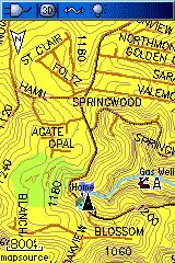
... the topo maps you make are better and they are transparant so you can see both topo and navigator maps.
What exactly does transparent mean? Are they superimposed on top of each other? Can someone post a screenshot?
Thanks.
Here is a picture of city navigator 7 and my custom topo maps. As you can see you get to use navigator along with your topo maps. No more toggling between the two and the custom topo maps are better.
-
You can always make your own topo maps. I make my own topo maps, with water data, for the places I hike. You can make your maps transparent, so the roads can be seen right under your topo. Here is the site I used to make my own topo:
http://home.cinci.rr.com/creek/garmin.htm
Supposedly, these home-made topos are more detailed than the ones you buy from Garmin.
how long do we need to spend time on making those maps? its kind of difficult i think to make those maps
The learning curve takes a while maybe an hour or so. To actually make the maps though now once I know how it takes about maybe an hour or so to make topo maps for a county here in western pa. This involves me downloading the data, converting the tif and then making the map. If your internet connection is faster or your computer probably is faster this will take less time. Also you can look at http://mapcenter.cgpsmapper.com/. People post their maps there and I encourage others to do so. I have been posting a lot of maps for Western Pa and plan on posting some more in the near future. I would say if you had to pick one I would go with Navigator then learn how to make your own topo maps. There is a learning curve but since everything to make them is free it is only your time and effort. Plus you can get a lot of help here on the boards and the topo maps you make are better and they are transparant so you can see both topo and navigator maps.
-
Thanks Bus36 for posting the above instructions. I have a couple of questions pertaining to the instructions, if anyone can help me; I would appreciate it.
I have created the .img file in GPSMapEdit with 2 Routes converted to Polylines saved as Internationl Boundary Lines, 16 Tracks converted to Polylines as Trails/Walkways, and 94 Waypoints converted to "Points" with custom Icon Symbols and text names/"Type" and "Labels". Somewhere in the process of creating the Text Labels for the Waypoints/Points the Color of the font was changed from black to brown on only 6 of the 94 Points; I've tried everything I can find to try to get the font color back to black and nothing seems to have any affect. Can anyone tell me what I'm missing?
When I opened GPSMapEdit it changed all of my Mapsource file name icons (.gdb files) that I have saved in "My Documents" from their generic Mapsource icons to the GPSMapEdit waypoint symbol (looks like a golf pin flag), is the normal? If it isn't how do I change them back to the generic Mapsource icon?
On Step 15 of Bus36's instructions it says to Click on file "save map as" and save your file. My question is really wanting to verify that the default of save map as "type Polish Format" is how it is supposed to be saved?
It appears that my map is correct so far as best I can tell up to Step 18 where I am stumped. I want to be able to load my custom map with other Mapsource Maps so I proceeded to the http://home.cinci.rr.com/creek/garmin.htm instructions for "Uploading Your Custom Map Using Mapsource". I've completed steps 2 and 3 (created folder named "Custom" under the Garmin folder and copied my custom map to it and copied cgpsmapper.exe to that "Custom" folder also. Now here is where I must be missing something; when I copy "test_pv.txt" to the "Custom" folder I created and then open Notepad to edit "test_pv.txt" like step 4 says to "make it look something like this" (as displayed on instructions). My "test_pv.txt" file doesn't remotely resemble anything like what the instructions show before editing. It is 3-4 continuos/unbroken lines of chararcters and text. What am I doing wrong and is there an easier way to accomplish this without have to do all of this editing and changes in the registry? All help will be appreciated, Thank You.
Ed
I am not sure about the color label issue. Are the waypoints labeled before you import them into gpsmapedit or maybe you label them afterwards causing the color to change. Other than that no ideas here.
As for the flag icons I haven't found a way to get it back I am just used to it now.
Yes you will save it as Polish format .mp
As for your test_pv.txt if you want to send it to my email address I can look at it and see if it looks good and offer suggestions. I am at work or I could send you a template of mine when I get home if I get . Hopefully you can get this to work you are almost there.
-
Here is a quick guide for making transparant maps of your trails. I used the website http://home.cinci.rr.com/creek/garmin.htm for the know how and just modified a few steps. Hopefully GeoBobC adds anything that I miss:
1. Convert your tracks to gpx file
2. Open gpsmapedit program then click file open and choose your gpx file
3. Click on file then map properties and do the following:
A. change type set to Garmin
B. give the map an 8 digit ID number
C. give the map a name
D. click on the levels tab and hit the insert before tab do this until you have level0= through level5=
E. Change the settings to look like this
Level0=24 bits mapsource zoom=under1.2km
Level1=23 bits mapsource zoom=1.2-3km
Level2=22 bits mapsource zoom=3-8km
Level3=20 bits mapsource zoom=8-12km
Level4=19 bits mapsource zoom=12-30km
Level5=18 bits mapsource zoom=50-120km
4. Hit ok which takes you back to your tracks
5. Click on edit, select all tracks
6. Right click on your tracks and select convert to polylines, this will bring up a level box
7. Select levels 0,1,2 boxes and hit ok
8. The type box will come up select walkway/trails then ok(you can change this to anything you want to have them come up on the gps different. GeoBobC selects International Boundary and says it looks good on his gps)
9. Next click on view, then levels and select level 4. You will see your track NOT your converted track more on this later
10. Right click on the track and hit detach file.(This gets rid of your track file but keeps the converted file that you already did. If you want to see your file click on view, then levels and select level 0)
11. Click on view, then levels and select level 4, Click on the wand tab(create object) and select point
12. Click on your map and create a settlement(less 100) and click ok
13. Click on file, mapproperties and select the cGPSMapper Tab
14. Check the Map is transparent box, then hit apply
15. Click on file save map as and save your file
16. Click on file export GarminIMG/cgpsmapper.exe(this has to be download prior so look at the website I provided), name your file and save it, then search for the cgpsmapper.exe file that you saved earlier and click on run.
17. Next find your newly created IMG file and change the name to the 8 digit number that you gave the map in 3B
18. Then you can send the image to your gps or mapsource. Look at http://home.cinci.rr.com/creek/garmin.htm for setting up mapsource or using another source since it describes it better than I can.
Good luck and let me know of any questions or if you have a better way or modifications let me know. Also feel free to share your maps at http://mapcenter.cgpsmapper.com/
-
Bus36
I may not have answeared you question very clerly. From what I understand about custom maps to create custom TOPO maps is somewhat involved (not what I'm want to do); so if I understand correctly how they can be configured all I want to do is create a simple map (with my tracks and waypoints already in Mapsource) making it transparent so my U.S. Topo map will still let me see all the map data from the U.S. Topo map on the GPSr and also my custom map at the same time.
Ed
I see. I am at work now but I will post walkthrough of how to create a custom transparent map of your tracks when I get home. It is pretty straight forward and I think others would like to do it too so I will try and post something we can all use.
-
I am wanting to create custom maps for a 60CSx using tracks and waypoints that I already have in Mapsource. I also want to be able to view these on top of Mapsource U.S. Topo, which I already have. I have looked at the instructions in http://home.cinci.rr.com/creek/garmin.htm and have read most of the threads pertaining to the procedure but it seems that most threads over simplify the instructions. My question is 2 fold: (1) are the instructions in http://home.cinci.rr.com/creek/garmin.htm the best route for me to go inorder to do what I'm wanting to do and (2) the insturctions don't say anything about needing to download and install IDL 6.3 Virtual Machine for Windows XP (I am using XP). When I read the detailed instructions for DEMO2TOPO it says that you must first install IDL 6.3 Virtual Machine inorder to open DEMO2TOPO. I have downloaded DEMO2TOPO and it appears all files are there but it will not run. So I wanted to verify that this also must be done.
If anyone would be kind enough to share an eaiser method with step by step instructions I would very much appreciate it. Thanks.
Ed
Do you want to create custom topo maps or simply maps using your tracks and waypoints? If I know which on then I can help you out.
-
I want to create a route with MapSource and then use my Garmin xTrex Vista Cx
(on my bike) to navigate the roads EXACTLY as created them. When I click
navigate the device seems to want to use other roads. I don't want
'shortest' or 'fastest' I want the exact rout I created.
Any help will be appreciated.
The way to do this is to use Mapsource and create a route. Then transfer this route to your unit. The go to the route page on your unit and navigate using the route.
-
I'm back from the loss of Mapsource. Odd, but the Topo patch fixed the problem (Mapsource would open and then immediately close, just after I altered the registry for custom maps). In case you're interested, check this link: http://www.garmin.com/support/download_details.jsp?id=209
Look on the right side for the patch. Never had the problem before, and I don't see how anything I did with custom maps should have affected it, but the patch fixed the problem. Go figure.
Now, back to the business of making custom maps. I'm a bit reluctant to put my toes back in the water after the temporary loss of Mapsource. I left off at the point of being able to create a map, and view the mapset in Mapsource. However, my problem was keeping all the trail details when going from GDB > MP > IMG. It looks as if the MP file has all the detail and is about 10x the size of the IMG file. Thus I suspect it is likely to be a setting in the cgspmapper Map Setting that is causing the problem. Levels, perhaps.
Is there a way I could email a . GDB/.gpx/.mp file to someone and see if they could get it to work (i.e. retain all the details of the original)? Would it be safe for me to post my email address in here and ask for a volunteer, or is there a common FTP site I could put a file at?
You can email your gpx file and your mp file and I will take a look at it when I get home. I will get home at about 5:30 or so and can look at it then. If someone else can do it before then, that is fine.
Also your IMG file is always smaller. I was surprised how much smaller it usually is. I would say that your levels are probably your problem. If you send me your stuff I can look at it, and also make a track file from your info and send it back to you so you can look at it.
-
Here is an update on my situation: I had great success. Even went caching with my new map.
I pulled the seamless elevation data for a large park that I wanted to go geocaching in. I kept the area small because I had a few failed attempts with using too large an area (computer churned and never finished). I got the img file of just the contour lines. Found the City Select local mapset that I use and told Sendmap20 to grab both it and the new topo map img file. Senmap also lets me add my unlock code. I generated the same thing for 3 GPSr (each with different unlock codes and using two map versions). All three worked like a charm. I would suggest to folks who are uneasy about messing with regestry entries to use Sendmap instead.
A question for folks who use DEM2TOPO: is there a way to tell if the downloaded elevation data file is too large for DEM2TOPO to finish? 50mB is too large for my machine. 4mB worked fine. Where is the cut-off in between?
The contour lines are great, but without trails on the map it can still be frustrating. I learned that the hard way in the park yesterday as I stood 80 ft below a geocache looking up a sheer rock wall (guess how I knew it was 80ft up). Then I needed to know which way around to the nearest trail. So the question: is there a source for trail data somewhere?
And finally: I am traveling to Korea in a few weeks. The USGS seamless elevation data website shows spacial data for that country. But I cannot seem to download it. Any ideas on how to make that work?
As for trails I haven't been able to find a site that has them. That is why I am hoping that people start to share their trails and post them on sites like mapcenter or such. Even if others don't want to make the maps I am willing to convert some gpx files of trails and such that they hiked and post them on mapcenter as maps for all to use.
As for seeing the trails when zoomed out further than 800ft if you convert your gpx files to a shp and then import them into the mapedit and import them into levels other than level 0 you can see them when you zoom out. This would be done that same as large rivers or such. I can't remember the program that converts gpx files to shp files but I can look when I get home or search here it was posted not to long ago.
-
OK. I assume that means: "Start > All programs > Accessories > Command Prompt."
At the C: "cd\garmin\gspmapper"
Then type in "cgpsmapper pv test_pv.txt"
Is that right?
This is the way that I do that step. I of course get the info from http://home.cinci.rr.com/creek/garmin.htm.
5.Then, open a "command window" (DOS prompt): Start, Run , type "cmd".
6. Change directory to the "custom" folder: Type "cd c:\garmin\custom" in the command window then type "cgpsmapper pv test_pv.txt".
This creates a small preview map file (.img), a table file (.TDB) and a registry file (.reg).
8.Edit the registry file (i.e. CINtopo.reg): Right click on it and select Edit. Change the folders (directories) so they point to your custom folder. Yes, you need the double back-slashes:
REGEDIT4
[HKEY_LOCAL_MACHINE\SOFTWARE\Garmin\MapSource\Products\CINtopo]
"LOC"="C:\\Garmin\\custom\\"
"BMAP"="C:\\Garmin\\custom\\CINtopo.img"
"TDB"="C:\\Garmin\\custom\\CINtopo.tdb"
9.Run the registry file (double click it) and select yes to load it into your registry.
10.Start Mapsource. If you made a registry file mistake you will get an error saying to reinstall MapSource. Don't worry, you don't have to reinstall. Just run regedit (seek help if unsure about this!) and remove the "HKEY_LOCAL_MACHINE\SOFTWARE\Garmin\MapSource\Products\CINtopo" key. Repeat the above steps until you get it right.
11.You should now see your map listed in MapSource along with your other Garmin maps in the 'Product' list.
-
I am looking to get some gpx files of trails that you have hiked, biked, or ran. I want to make some transparent trail maps and then share them on http://mapcenter.cgpsmapper.com/. These maps would be used on a garmin and would be able to overlay city navigator and topo maps. Let me know if you have some, think it is a good idea, or should just scrap the idea. Any thoughts would be appreciated.
No replies? I am willing to convert gpx files of trails in Pa to maps that we can all load into our gps. Any takers?
-
Thanks Red90. Here is my updated list of required components: (1) track, (2) Mapsource software, (3) gpsmapedit software, (4) cGPSMapper software.
I like the preview option. Thanks.
I was just getting ready to post but others beat me to it. That is pretty much it. I like to use the preview option since this allows you to load you navigator, topo, and your newly made trails all to your gps. Let me know if you have any questions.
-
Do you curently have Garmin City Nav or Topo maps under Mapsource? If you do and you just want to display the multiple tracks, I would think you could set up the tracks on Mapsourse to look as you want and then download them to your GPSr to be displayed on whatever the appropraite pre loaded maps is. Does that work?
Nevermind. :-) I just saw your other posting and see that you are challenges by the number of tracks you want to disply. The custom built map layer sounds like a better solution.
I just started to build some maps and tracks. I have to say that building topo maps is time consuming but if you wanted to just build some track maps it is a very easy and quick process. When I get home I can post a step by step on how I perform the task and it works pretty well especially since the track maps will be transparent and will show up both on the gps no matter what map programs you have loaded. I haven't perfected the process yet but I am satisfied with the end result.
-
I am looking to get some gpx files of trails that you have hiked, biked, or ran. I want to make some transparent trail maps and then share them on http://mapcenter.cgpsmapper.com/. These maps would be used on a garmin and would be able to overlay city navigator and topo maps. Let me know if you have some, think it is a good idea, or should just scrap the idea. Any thoughts would be appreciated.
-
I would have to agree that rolling your own maps is the way to go. You could make topo maps transparent with your trails on them or you could simply make a transparent map that simply has your trails on it which would be simple and quick. I just started to play with this stuff and it isn't to bad. Making your own topo maps is a little time comsuming but if you simply made transparent trails I think it would be quick and easy.
-
You could use SendMap to put them together and send them, but I prefer to make a "Custom Map" product and load them with all the others through Map Source.
There are two ways to go about making, compiling, and sending maps:
The easiest and pprobably the best documented is here
I also use a combination of GPS TrackMaker and MapDekode found here
The trackmaker info is a little dated but his product is first rate.
As mentioned before, share your maps at the above linked address.
Scott
Thanks for the help. I had another question. How big can you make the maps. I am using gps trackmaker and have been trying to make topo maps for four counties here in PA. When I go to export the product which when saved is about 1GB it say something about not being in order or something like that. I am thinking maybe the file is to big. How big or small do you have to make the maps and if you make say 5 counties seperate can you load all of them on the gps at once? Thanks for the help. I hope to get this down here quickly.
-
I started on the task on making my own maps. It is a little time consumming but not that bad. My questions is for the 60cx. I have made the maps and now it is time to load them into the gps. I have a 1GB card so I was hoping that I could keep my current maps on the card and simply open up the card and insert my new maps. Is there a way or trick to do this so I do not want to load the 1GB card once again since it takes some time. Thanks in advance. I am trying to find all the tricks to this process that I can.
-
Me and my brother in law went canoeing a while back. I have a 60cx and he has a 60csx. Both units where exposed to the rain in a down pour. We were soaked. Anyways the next day we went the same trip and my brother in law was jumping from a canoe to a kayak and fell in with his gps hooked to his belt. It was probably under about 3 feet of water for about a minute. Not that long but he never turned it off and it was fine. That was about a month ago and he hasn't had a problem since. I kept mine on during the down pour and haven't seen anything so I would say it is pretty good.
GPSMAP 60CSx and MapSource Topo
in GPS technology and devices
Posted
Which area are you looking at? It is a process to get started but I am willing to help if needed or to anyone else out there that wants to take the leap. I have helped some already and am willing to do so. I think it is a great feature and the maps make the gps that much better.