

Bon Echo
-
Posts
228 -
Joined
-
Last visited
Everything posted by Bon Echo
-
Super Fund sites outside USA
Bon Echo replied to Alfouine's topic in Recruiting and Category Proposals
PISA-caching, I took a look at the Austrian database (impressive I might add, very detailed!). I looked at a few of the "secured" sites and agree with your conclusion - appears to be sites where actions were taken to reduce exposure to those chemicals. In toxicology / risk assessment, Risk = Hazard x Exposure. Hazard is the toxicity of something (a physical or chemical agent). Exposure is is just that. The gasoline/petrol in your car might be very toxic to you, but the risk to you while driving the car is negligible because you are not exposed to is - it is in a sealed system. It is a similar calculation with these sites. Previously, the chemicals might have been able to enter into drinking water or air and therefore the exposure risks were higher. After some actions were taken (maybe capping the site with clean soil), the risk is considerably lower. Although the contaminants might still be present in dangerous amounts (Hazard), the "risk" is reduced because of exposure is reduced. Hope that makes sense. In that list (Austria), I think all sites (secured, remediated, contaminated site) should be accepted. Those sites are - or were - heavily contaminated and do - or did - pose a significant health risk. The difference with the Canadian list is that it seems to include every federally-owned site that might have contaminants, and those sites are listed before being tested. AND they continue to be listed, even after testing is conducted and shows no contaminants. Such as the RCMP detachment that Keith mentioned. Keith, I like your proposed changes. I think this might only be relevant to the Canadian sites given the nature of the Canadian database. In fact, after spending too much time clicking around the Canadian database, I recommend that Waymarks of sites from that database only be accepted if the site has been 1) thoroughly investigated and 2) found to require some sort of action to reduce hazard. I think the easiest way to do that is to only accept a site once it reached one of these Steps 07. Develop Remediation/Risk Management Strategy 08. Implement Remediation/Risk Management Strategy 09. Confirmatory Sampling and Final Reporting 10. Long-Term Monitoring (Optional) You can view the list of various levels and the number of sites at those levels here: https://www.tbs-sct.gc.ca/fcsi-rscf/ls-de-eng.aspx This effectively excludes sites that are of no concern (testing reveals no or low levels of contaminants). It also defers acceptance of sites where detailed testing remains to be completed - such sites might be acceptable in the future, if the testing reveals the need for Remediation/Risk Management Finally, one shortcoming of the Canadian list is that it excludes many contaminated sites that in the US would surely make the Superfund list, but they are not on the Canadian list because they do not come under Federal jurisdiction. A prime example would be Central Park in Hamilton. Please read the linked article consider how those sites could be accepted to the Waymarking SuperFund category Hamilton’s Central Park Soil Contaminated with Carcinogens: Environmental Site Assessment Reports And another example: ‘Recovery can take years’ — assessing the future safety of contaminated site (if you get a pop-up blocking out most of the article and asking you to sign in, try refreshing the article. That worked for me) Thanks, Jason -
Super Fund sites outside USA
Bon Echo replied to Alfouine's topic in Recruiting and Category Proposals
Another observation if I may. I have only yet looked through the Canadian list and I have noticed that practically every (or at least very many) DND (Department of National Defense) sites, and Water Survey sites (gauge stations) are listed on the Canadian list (actually, I will simplify this to say many Federally owned and managed sites where hazardous chemicals may have been used or stored). I think they were all put on the list for evaluation, and some of them have since been evaluated and deemed to be not of concern. Should those sites also be acceptable? It is a conundrum, because a site may be waymarked before it is evaluated and later it might be evaluated and found to be not contaminated. And I feel like this is a departure from the Superfund List, where (I imaging, but don't fully know) that a site is only added to the EPA Superfund List after it has been evaluated and is found to be contaminated here's my favourite example as it is also very local to me: the Burlington Bay Main Light (old stone lighthouse) - managed by Fisheries and Oceans Canada and the chemical of concern is...guano! Yes, bird crap! Status: Remediation / risk management completed. No further action required. Site Status: Closed Classification: Not a Priority for Action One could easily Waymark this nice old stone lighthouse into the revised Superfund category, but does it truly meet the spirit of the original category? (side note - there actually was some sort of clean up at this lighthouse to remove the bird crap - but there is nothing in the linked page to suggest that any work was done (. I only know about the work because I'm local and it's of interest to me, but a traveling waymarker might not know such details) Okay, maybe the above example is not the best one, but there are numerous examples of sites in Canada that are listed, have been evaluated, and deemed to be "okay" without any need for remediation - a few examples include: Site 00022221 - High Level RCMP Detachment Site - Alberta Site 00020617 - Fort Shepherd Upper - No Contamination Identified - British Columbia Site 00012665 - PORT DALHOUSIE-MARINA (No Contamination Identified) - Ontario Site 00015226 - Port Dover Gauging Station (No Contamination Identified) - Ontario Thanks to the three new category managers for wresting through these issues. I really look forwards to adding some sites to the revised category (don't know why I never thought to target this category while visiting the USA - maybe I knew my family would not be impressed stopping by wastelands while on the way to vacationland) -
Super Fund sites outside USA
Bon Echo replied to Alfouine's topic in Recruiting and Category Proposals
Thanks Keith, nice to "see" you too and hope you are well. Now I'm worried I might have over-sold the Great Lakes AOCs, specifically my comment about the signage. There are many AOCs that I have not been too so to be honest I'm not really qualified to make the statement about the prevalence of signage. Each AOC RAP (Remedial Action Plan) Committee operates somewhat independently and while one committee might be inclined to sign, others might choose otherwise. I know that a sign is not absolutely required under proposed revised description (I misunderstood that it was, upon my first read), but I'm just trying to imagine how some of the AOC might be waymarked. I think the challenge is similar to that of Waymarking a natural lake; from the Natural Lakes category description: Here's is a better link for the AOCs - a page that actually lists the various AOCs https://binational.net/2014/10/31/status-aocs/ Let me think about it some more -
Super Fund sites outside USA
Bon Echo replied to Alfouine's topic in Recruiting and Category Proposals
Oh, and I would also suggest adding some variables such as Major contaminants (ex oil, coal tar, PAHs, PCBs) Location type (water body, land, etc) Contaminants are in (soil, surface water, ground water) Status -
Super Fund sites outside USA
Bon Echo replied to Alfouine's topic in Recruiting and Category Proposals
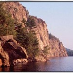
Nice to see this category may be revised. An an environmental toxicologist the subject is of interest to me. A few comments if I may: I don't know that all locations will have a sign. For example, My M.Sc. work focused on highly contaminated sediments at Randle Reef within Hamilton Harbour (Ontario). The contaminated area was located offshore. The only indications of the location (at that time) were navigational markers that restricted boats from entering that area. The adjacent shoreline was industrialized and off-limits to the public (inaccessible). However, a containment structure has since been constructed over a part of the area, so possibly there are signs (or at least there is a structure that can be photographed). So I guess what I'm saying is to consider how to handle sites with no signs, or signs that are fully off-shore. Also, some of these sites might have a very large perimeter fence, so getting a suitable photo of the site might be a challenge. I'm thinking specifically of the Sydney Tar Ponds in Nova Scotia, which I visited in 2010 (a few years before I began Waymarking and taking thousands of photos per year) - although I did manage to get a somewhat-representative photo from a boat while working in the adjacent harbour Another comment on the use of the term "contaminated sites" - you might want to add a qualifier, maybe something like "nationally-significant contaminated sites". A house with a leaky heating oil tank might be a contaminated site, but it's not significant. Personally, I would prefer to see the title changed from Superfund Sites to something less US-specific, again I suggest something along the lines of "nationally-significant contaminated sites" or "Priority Contaminated Sites" And here's another list to consider adding - Great Lakes Areas of Concern. I've been fortunate to work in a hand-full of the Canadian AOCs. Again, these locations tended to be offshore with few visible structures (if any) and cover a wide area, but generally there will be at least one infoboard sign installed by the local AOC component in a publicly accessible spot (almost a requirement of the delisting criteria it seems) For fun, I leave you with this lovely image I took from 1500 ft (and that's all I'm going to say) I'm a little scatter-brained this Monday afternoon so I might have missed something and didn't read through every line above but happy to reply to any questions / comments

-
I just saw this and want to apologize, sorry about that.
-
Sorry Max and 99 I don't have any but will send any that I find your way. If you have time and want to search on Find-A-Grave or the Canada Cemetery Project website, cemeteries in Hamilton (Hamilton-wentworth) or Niagara region (Canada), I will be happy to stop by those cemeteries to take the photos (so much easier when I know what to look for). Otherwise it will be a matter of chance while strolling through cemeteries. Example https://www.findagrave.com/memorial/search?firstname=&middlename=&lastname=&birthyear=1900&birthyearfilter=3&deathyear=2000&deathyearfilter=3&location=Hamilton%2C+Hamilton+Municipality%2C+Ontario%2C+Canada&locationId=city_251707&memorialid=&mcid=&linkedToName=&datefilter=&orderby=r&page=1#sr-158702257
-
Thanks Keith, not going too far. I'll still post new waymark occasionally, and still managing the few categories I'm an officer in. The Waymarking bug is hard to shake off, and I'll probably always have an interest in a few of the categories as well as slowly adding new categories to my grid.
-
I've pretty much lost all interest in creating new waymarks, just don't have the time to put towards it anymore. Problem is, I just can't seem to stop taking a dozen photos of anything I find interesting while out and about (although slowly getting better at this). So if there's a category in my region (Ontario, Canada) that you want to add to your grid, let me know and I will try to get you photos and coordinates. I thought I would do this with the Uncategorized Waymark system but a bit of trial earlier revealed that I no longer know how it works. Far quicker for me to just send you the photos by email. Message me with your email address and what categories you are interested in. Some are harder to find so it could be a while, as many of the local targets are already waymarked but the supply is not completely exhausted (examples: Ontario Heritage Plaques, Canadian National Historic Sites). Ontario Heritage Properties are no problem, many available in that category. I might have a few Atlantic Canada Heritage Properties and War of 1812 available. And if you just want to add waymarks in any category let me know, I have a collection of photos from several provinces and states across Canada and the US that I can share as time permits Only thing that I ask is that you do what I am no longer willing to do - a bit of research and some effort towards the long description. Happy Waymarking
-
My concerns with this game have nothing to do with running out of things to waymark or visit. It's more about running out of the web service itself. At the end of the day, all I have for my efforts is a whole lot of data stored on GS servers. If they ever pull that plug, hundreds of hours of work are lost. It takes me minutes to visit a waymark (as in posting a visit, but the act of physically visiting the location and taking photos is nearly irrelevant because 90%+ of the time I go there because I want to, not because of Waymarking). But creating each waymark probably takes me on average of 30 minutes. I'm up to 700+ waymarks so you can do the math. And I'm a "small time" waymarker with numbers like that.
-
The Great Trail (formerly Trans Canada Trail afaik) claims to be 24,000 kms. I'm sure there are a few waymark entries for it. I have photos to make one, but it's in the low queue of waymarks "to post someday when time permits"
-
Go to Flopp's Map (www.flopp-caching.de), search for the location you want. Then on the bottom left there is a drop down menu titled "External Services". Select "Waymarking" Easier that typing in coordinates

-
So April has come and gone and May is nearly out the door. Anyone notice and hear anything about changes? Yours truly, Curious George.
-
Personal "Rules" for Waymarking
Bon Echo replied to vulture1957's topic in General Waymarking Topics
I rarely plan ahead. usually the extent of planning consists of checking the list of WMs in an area I am visiting to see what's been covered, but that might happen 2-4 times per year. And I don't have data so once I'm out it's a guess. most WM photos are taken while traveling for other purposes, only a few times do I actually go out to some location just for Waymarking (although I may stop "along the way" just for WM photos but I can only do that so many times before I get into trouble with the rest of the family). I try to limit my cross-posting. Generally if a waymark can go into two very similar (to my opinion) categories - like churchyard cemetery and cemeteries of the world, or Anglican church and This Old Church, I usually choose the more exclusive of the two (i.e. churchyard cemetery and not cemeteries of the world, This Old Church and not Anglican church). It's not a strict rule, sometimes I will do both to gain a category or to increase numbers posted to a certain state etc. I don't care about my numbers Posted and Visited, so that's part of why I don't do a lot of cross-posting. Once I have shared something that I felt was interesting, I just don't see value in repeating it 2, 3, 5 more times. Now if it brings out some interesting new feature, then I might be interested. I almost never visit my own waymarks (maybe a few times, can't remember 100%, but it would be less than 10 visits in total) I almost never post a waymark unless I have been to the spot / location myself and took the photos myself. 2 or 3 cases outside this rule (one was an uncategorized waymark, the others were not my photos but I had been to the location and had permission to use the photos). I posted one waymark to wikipedia entries and probably will never post another one, to me it's just way too vague and very few things can be posted there that cannot be posted to another category. Most times if I visit a location and take pictures to waymark, and find it's already posted, then I post a visit. And above all, I am inconsistent. Not on purpose, but this is a hobby and I enjoy it the best when I play it the way I want. And the way I want changes over time. By far the biggest challenge to me with Waymarking is the pathetic number of page visits - I can spend an hour or more on a single waymark and then 5 years later see that the page was visited maybe 2 or 3 times. Never mind physical visits to waymarks I post, that's an even smaller number. -
What, nobody interested? Maybe I should have reported that the comments were made by current Groundspeak president Bryan Roth and that they hint at upcoming changes on Waymarking.com
-
Oh, and just because it's easy to check: there where 67081 waymarks added in 2018. Does anyone track the number of submissions per year? I'd be interested to see those stats if they are available.
-
Currently listing to the Geocaching Podcast (first time actually), and there's a bit that Waymarkers might be interested in listening to. You can listen to the entire podcast if you want an interesting inside look at the early days of geocaching.com, or you can skip to 45:00 to hear a few comments on the Waymarking side. http://geocachingpodcast.com/gcpc-episode-550-the-evolution-of-geocaching-with-bryan-roth-2000-2007/
-
I wonder if the owner want you to visit the posted coordinates - the location - and not just the blog itself?
-
Do you think this would fly in the Unusual Signs category? The "sign" is posted on a toilet seat in the washroom of a dive shop. It's a single-person washroom, so there are no "accessibility or privacy" issues other than if the store is closed, or maybe having to wait for the washroom to be available. Actually, it was less awkward taking this photo than it is for many other WM photos (in busy public places) One issue maybe is that I don't have the "general area" photo but really I can't get much more in the view standing in a 5'x5' tiny washroom

-
funny to see this come up as I just submitted a WM of a plaque on a lych-gate. I've seen 2 or 3 around in my travels this year in Canada. EDIT: the fact that it was on a lych-gate was irrelevant to the WM I posted.
-
Absent Leaders and Unresponsive Officers
Bon Echo replied to wayfrog's topic in General Waymarking Topics
Sorry to bother you again but I have the following submissions waiting 2-4 weeks for review: Little Bay de Noc campground - Rapid River, MI in Campgrounds Submitted November 19 CEYLON GAP SWIM - Ceylon, Saskatchewan in Public Swimming Pools Submitted November 21 Faith Life Church - Branson, MO in Megachurches Submitted November 21 Always Rd Bridge - 1933 - Grassie, ON in Bridge Date Stones and Plaques Submitted December 1 Thank-you again for your time and Merry Christmas and happy holidays -
Mountain Summits looking for Officers
Bon Echo replied to RakeInTheCache's topic in Recruiting and Category Proposals
I say don't make it more complicated than it needs to be. Lets face it, there are very few waymark visits as it is. The waymark owner can decide if any visit it legitimate and can delete one if they feel it is not. So what if someone logs a visit that they didn't actually do - who's keeping score anyway? We're talking about a rare case anyway. Beside, I can tell you that as a category manager you can make the changes, but if the waymark owners don't police their WMs, are you going to? Sounds like a lot of work to me. Not trying to discourage you from trying to make rules clear and consistent, just provide my thoughts. Looking forward to "earning" a submission to this category next time I visit the Canadian Rockies. -
I wanted try for a couple ISS viewings in November, but it seemed to be cloudy - for the entire month! At least it felt that way. But now that a Canadian is back on-board the station, I have a renewed interest in viewing it as it passes over BTW on a letterboxing website that I frequent I saw this in the "This Day in History" feed: okay, funny story - after writing the above, I thought I would check the predictions to see what passes are in the future. What I discovered was that the ISS was passing over at the very moment I checked. Of course I ran out the door to have a look at the sky is perfectly clear, but with a max altitude of 17 degrees there's no way I was going to see it surrounded by trees and houses.
-
Yet another broken feature on the web site...
Bon Echo replied to The Snowdog's topic in General Waymarking Topics
Still broken, but I'm only "discovering" this now. Looking for a waymark I visited, it's now archived so searching through My Visits is the only way to locate it (since I don't know enough to try a google search for it)...but since the My Visits is broken, so is my hopes for finding the waymark I can view the first 10 pages of visits, and the last 2 (page 41 and 42), but nothing in between those. -
I think you can submit to the silhouettes to the Silhouette Public Art Sculptures category, as long is it's in a public location. But you probably know that already.


.png)

