

viking66
-
Posts
95 -
Joined
-
Last visited
Everything posted by viking66
-
I am fan of motorcycles. Road Racing, Dirt,Trials its all good. DNF is used there to denote in a race standing or result: Did Not Finish. Its UGLY. For whatever the myriad of reasons, be they mechanical, spiritual, bluntforce,whatever. NO GOOD.Which brings me to today. There we are, a caching buddy and myself, and we were 1 for 3 today. On a day of DNF retries. Getting the picture? Oh, the redeeming aspect was getting the micro that was really well hid; a good hide. But of the other two. GRRRRR. Sure weve got a littany of reasons; bounce, bad math (not ), sun was in my eyes, the whole nine yards. One is a second stage of a multi, dastardly well hidden, recently found by some seasoned searchers. That caches owner got hung up on stage 2 of my cache, so were even. Well actually ,no, he found mine in January. The other is by some neophyte who seems to have a knack for hiding things really well. All I can say is Ill be glad when Im past these. Thanks for the vent. Peace
-
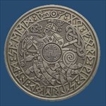
A pair of '06 Compass Rose coins. WOW, they are spectacular. Firey & Shiney. Very nice.
-
Audio Engineer / Sound Editor
-
Hi Brian, We met at the "Fire and Ice" event in December. Thanks again for the Volunteer Coin. Good tip on the defacing of the container. The Long Path doesnt need what appears to be caustic device. Thanks Kit Fox, your place has a better price, but noy by too much, so Im not too upset.
-
Well, that didnt take long, I answered it myself. I found it! in a sets of four no less @colemans.com
-
Im in need of those Decon kit containers. Ive got a couple of places that need caches, but an ammo can is inappropriate, and Im not into tupperware. I am open to ideas, Im not a closed minded needy person; its just tupperware... I dont know where we went wrong. So before I stray too far away, where do you get the Decon kit containers, Ive hit many Army Surplus places and eBay; maybe its a timing thing. Maybe its me. So there it is.
-
THANKS GUYS! I'll keep hoping.
-
I recon this maybe misplaced, but for those who responded to the presale email from USAGEOCOINS for '06 The Compass Rose Coin, have you heard anything? I was of the mind that those who made the cut were to receive a bill by now. Has anyone gotten that far? or should I just presume that I missed another boat?
-
Finds To Hides Ratio
viking66 replied to stickmonkey and stickmonkey jr's topic in General geocaching topics
100:1 YEA! I got to 100 on Saturday! -
SCREEN NAME IS MORE THAN AN ALIAS
viking66 replied to sept1c_tank's topic in General geocaching topics
Mine,viking66, is from my mothers lineage and my own( birth year ). My five year old son's is from the first cache he found; he pulled out a "little owl" hence his woodsname was found. -
The PDF printable has become my choice for info in the field. I like the large waypoint in the upper right. I have no printing issues Mac OSX using 'Preview' by default. It works great. Much cleaner than the 'Make Printer Friendly' version. What I'd like to see might give you a fit. Id like to see multiple waypoints to be selected as an itinerary. For example, as you see that you may check off multiple waypoints for .loc downloads, I think it would rock to download, in order of occurance, the names , waypoints and coords to one ( or many paged ) .pdf file. Just a little something to keep you up at night Thanks for the great work, and Happy Holidays to all!
-
Thanks guys thats what I thought. Happy Holidays all!
-
Hello all, I have a question regarding the logging of geocoins that I had been shown and invited to log. In short, how would I go about doing that. Do I log it, or 'grab it' and thats the end of it? Or do I log it and drop it back at the event that Id seen them. I've searched for this answer to no avail. I am even unsure if what Im asking is right or ethical (Im thinking too much, I know) actually, I felt Id only log those I had in hand ( that made me feel better ). Alright, so lets hear it. Thanks in advance, and Happy Holidays all!
-
I was just in a place that I got to first. Yeah, an FTF! The snow fall of the previous night put a smile on my face; I knew I had it. Although, I thought 'I knew I had it' at a couple of other probables for this cache. My meanderings I thought were a good thing upon reflection. To the actual cache site, I had the good fortune to be on a road a couple of feet below GZ, so I back doored the thing ( in this case easy to do ), thereby leaving little evidence ( from the road at least). Later that night, I had another first. My first night cache ( in snow of course ). That was cool ( cold ). I and another trod recklessly through the area, thinking the weatherm en would be righton with their 4-6" more prediction. Well, we got the cache, not the snow. Oh well. Tread lightly if possible, if not, be bold in the cold! -viking66
-
MagicTogether, Hi, I've got the same set up as you. How has your experience with your 130 been? Mine excellent. There were questions about its two way radio, but Ive found it to be pretty good actually; working well with my Motorola two ways. The Garmin IS a battery hound though; so you have to remeber to turn off whats not going to be used and get a power adapter for the car. My understanding is that maps on the Garmin are proprietary, so you have to find a "friend" with a PC. I know Mac users say: 'we have NO friends like that' but it does help to find some. What is the National Geographic SW like?
-
By the by, my only issues with the MacGPS Pro software as it stands, is a little clunkiness in its usability. Items in its tool bar would be better served as Command-letter or number selectable; as it is, the windows are currently Command-numeric which isnt needed as much ( just Command - tilde for that thanks ). MacGPS Pro is not the app. of choice to log your geocaches either but then, do you need that when you GC.com? Not really. So in short, Im happy with MacGPS Pro. They are, I think small and responsive. Good luck with your decision.-pc
-
Check in the HW / SW forum or better still, OS X Search result
-
Hi, Being new to it ( MacGPS Pro, GPS and geocaching etal ), please dont let me lead you astray. As to your first question; I have no answer, but their tech suppport is responsive so thats where Id go to find out. For your second question, I believe their update of this past week stitches maps together. Also see the following... FROM MacGPS Pro HELP PAGE... Auto-Open Maps MacGPS Pro can find and open USGS Digital Raster Graphics (DRG) map files that use the standard USGS file naming system. In order for this feature to work, the “Auto-Open Maps” folder (that comes with the MacGPS Pro program) must be in the same folder as the MacGPS Pro application. Only MacGPS Pro PICT format USGS digital raster graphics maps inside the “Auto-Open Maps” folder will be opened automatically. To convert a file in another map format into a PICT format file, see Import Maps. (Because of limitations imposed by our license from MapTech to read BSB files, BSB charts cannot be converted to PICT format.) Once the maps are in the PICT format, you can store them in the “Auto-Open Maps” folder. Simply move them to this folder in the Finder. If you do not want to store the maps themselves in the “Auto-Open Maps” folder (for example, if you have the maps on a CD or a DVD), you can put “aliases” to the maps (which are like little reference tags) into the “Auto-Open Maps” folder. Here's how: Insert the DVD or CDROM containing the maps into your Mac. In the Finder, go to the window that shows the maps you want to use. Select those maps. Hold down the Command key and the option key at the same time. Drag the icons for the map files into the “Auto-Open Maps” folder. To automatically open a map, choose one of these methods. If you are not displaying Real-Time data: From the Edit menu, choose “Find USGS Topo Map Name from Location…”. An Enter Coordinates or Quad Name window will open. Choose the desired map scale. Enter the Quad Name or the coordinates for your desired location. Click the “Find and Open” button. If you have the GPS hooked up and are displaying Real-Time data: From the Real-Time menu, choose “Auto-Open Map for current location…”. A window will open. (It will not ask for coordinates because the GPS receiver is supplying the coordinates.) Choose the desired map scale. Click the “OK” button. As you travel, the old map will close and the correct new map will open automatically as long as the appropriate map is in the “Auto-Open Maps” folder. Discover the convenience of James Associates' MacTopos USA DVD and the National Parks CDROM series. Both are value-priced and ready to go with MacGPS Pro. END OF COPY Does that help? -PC
-
So, let me see... Ive got a Garmin Rino, that'll only take Garmin maps. Right? Thats OK I got that part covered I think. As a mac user, Im with out the seamlessness of one mapping software that I may visualize / organize and easily transpose info to my GPS receiver; i.e MapSource. I am however, able to up load; using MacGPSBable and geocache.com waypoints (.loc file) and send them into my GPS : geocaching minimum needs are met. Missing really is the ablility to pull GPS info of mine, down into my mapping( which I have not got. yet ). Are there any solid solutions for mapping on a Mac? Is there something else Im missing? A level of functionality I could use better? Lots questions eh? Sorry Im new here. BTW, Hi, Im Paul and I dont know how this could be, but with this GPS in my hand, I still feel a little lost. Thanks in advance, -pc
-
Before you sink hard earned into the simulator for that other platform, I'd question whether Virtual PC v.7 is going to be USB savvy. Or worse still, serial > Keyspan >USB. I have been of the same thinking; running VPC7 and getting the most out of all this greatness, but Ive heard one too many horror stories about hardware recognition , drivers , speed issues etal. I dont want to be a wetblanket, heck this is the closesest I would ever get to buying Microsoft anything ( I dont think I'll ever feel clean ), I just would want a heads up.-pc