


PhntmArcher
-
Posts
146 -
Joined
-
Last visited
Posts posted by PhntmArcher
-
-
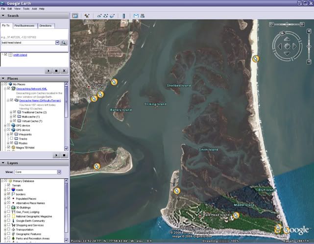
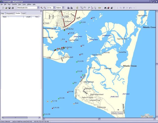
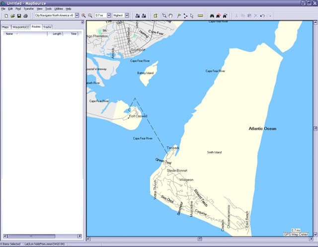
Hey, at least you responded. And, no, I didn't take it as a Smart a** comment. But to answer your question, I would like more of the features that were available in MG4. MG4 had significantly more geographic/topo information than any of the City Select/Navigators. I did a quick look at your area and the differences are not so great, so that's good. But here are a couple of maps for an area that I like to fish in NC. Sorry if the images are large. The detail does not increase if you zoom in on the CN8. I can't even find Striking Island or Shellbed Island on CN8!
Here is Smith Island (Bald Head Island) NC from Google Earth:
Here is the same area from MetroGuide4:
And here it is from City Navigator 8:
-
From an outdoorsman’s standpoint, I must say I have been disappointed with the recent mapping offerings from Garmin. Don’t get me wrong, I love my Garmin 76C, and 76Cx units and their capabilities. This is not meant to start a bashing thread. But, it seems to me that the mapping programs, City Select/City Navigator are focusing all of their efforts strictly on “driving” features and POI’s and has neglected geographic features completely.
This software is probably great for StreetPilots and other vehicle units, but are lacking for “outdoor” units. Yes, I have topo and it is fine once I am out of the vehicle. I guess that I got spoiled with my first autorouting program, MetroGuide 4. It seems that MG4 combined the features of “driving” and topo. I have City Select 6 and 7, and now City Navigator 8. I like the ability to find a “geographic” POI and then autoroute directly to it.
Not to mention the accuracy of the geographic features, which are significantly more general now than in MG4.
Any chance of lobbying Garmin to make changes, or a new product tailored for the outdoorsman?
-
For the difference in price I would much rather have this:

-
I believe that may be true as long as you utilize that route for the duration. It will try to route you to the nearest point. However, if you navigate to a waypoint outside of the route and and then try to re-engage the route it wants to start you at the beginning.
-
Well myotis, I guess that is the best solution. I called Garmin today to see if they had a better solution, and their suggestion was to route waypoint to waypoint (one at a time) rather than use a predetermined route. But I think that deleting the prior waypoint is a better solution. Oh, well.
-
How long does it take to figure out that you are not going to run the route in its entirety? I have worked with the routing and even tried to select the nearest waypoint in the route from where I currently was, but it really wants me to start at the beginning. It seems like it kind of defeats itself. It acts as if it is an “All or Nothing” thing with the route.
-
Has anyone been able to get this update? When I click on the link all I get is "Page Can Not Be Found".
-
Perhaps, I am doing it incorrectly, but if I am in transit and I then choose to use a route, it seems to want to some how get me back to the first waypoint and start the route from the beginning.

-
Starting Route In The Middle
If I have a route (a long route, 1,000 miles plus) setup on my 76Cx and somewhere during my trip I decide to use that route instead of just going to a waypoint, will it try automatically try to start at the beginning of the route, or will it determine where I am and begin routing from that point forward?
-
The exception to that rule is MetroGuide v4. Although a bit dated, it really does have some great features and will auto-route on the GPSr.
-
Thank you.
-
Is is possible search or run a Pocket Query based on the owner?
-
Is there a way to search the "Members" by state?
-
I hope not. That would be one to put on the Ignore List.
-
Dang, I thought that maybe there really was a way to do it! Well, thanks for clarifying that for me.
-
Everyone's agreeable to Pizza, so as we're headed east, I do a search for the nearest Pizza Hut in a range of 60º to 120º (ENE to ESE) of us.
Hey Neo_Geo, how do you specify the direction of the search?
-
Airman is correct. You will only be able to see one at a time. Multiple map sets can be loaded but only 1 will be visable. If they are all (both) set to display the dominant will be shown. Order is: City Navigator (or City Select), MetroGuide, Topo.
-
Please CLOSE thread when Sold.
-
It might be interesting to check you tracks, if you happened to leave it on during its ride on the roof. And maybe you should buy a lottery ticket today... it does seem to be your lucky day.
-
See, this is why I ask you guys. I tried doing a search on Ulta II but the II was too short and returned an error. Thanks for the input. Probably saved me some aggravation.
Thanks.

-
I have the Sandisk 512mb card in my 76Cx, but I am looking to order the 1gb. Has anyone used the new Sandisk Ultra II MicroSD cards in their X unit? Just don't want to get it and find out that it is not compatible.
Here is a link: http://www.sandisk.com/Products/ProductInfo.aspx?ID=1874
-
If you want to reduce the amount of time it takes to load the maps, put the MicroSD card in a USB card reader. This will greatly improve transfer times.
-
Please Close Threads when units are sold.
-
It was a joke... lighten up Francis.


City Navigator Not For The Outdoorsman (?)
in GPS technology and devices
Posted
It is beginning to look like I might have to explore making my own. I was hoping that it would not come to that, but it seems that the commerical products are going to street navigation like HikerGPS said. I thought (hoped) there might be enough of us out here to influence Garmin, but if the demand is not there it is unlikely to happen.