


Difficult Run
-
Posts
422 -
Joined
-
Last visited
Posts posted by Difficult Run
-
-
-
I will echo dirt_empire's sentiments.
Personally, I'm glad there are protected areas.
~ Mitch ~
-
During this recovery attempt, a dead steep (or maybe it was a dead SHEEP), caused some problems.
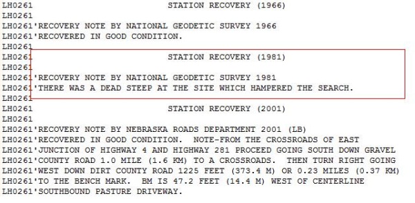
I'm thinking they meant dead STEER.
~ Mitch ~
-
-
Hey George,
There may be some aluminum marks nearby, but I suspect they are set by the U.S.G.S.

Results of Spirit Leveling 1896 to 1909
~Mitch ~
-
-
Well, it's a USGS benchmark with an elevation of 2242 feet, set in 1928.It looks to read TT STA NO 2D 1928.
Coordinates: N 35 41.231 W 083 23.933
TT STA NO 2D = Transit Traverse Station Number 2D.
It's not in the NGS database and probably the only info you'll find is in a file cabinet at the USGS Headquarters in Rolla, Mo.
You can write them a letter and they'll send you all the benchmark information for that quad.
It is denoted on the USGS topographic map for that area.
Regards,
~ Mitch ~
-
Cool.... free flash drives!


-
This topic came up about two years ago.
Here's the link.
... and a pdf copy of the book for your perusal:
Descriptions and Elevations of Benchmarks on the Missouri River
~ Mitch ~
-
-
I'm pretty sure we call that snake a Rat snake. Looks like one anyway.
Snake? - Where?
-
Does the "28T" shown on the one I posted about mean anything? I'm quickly becoming more interested in benchmarks and am realizing there is much to learn if I want to make the leap from stumbling upon them to actively.
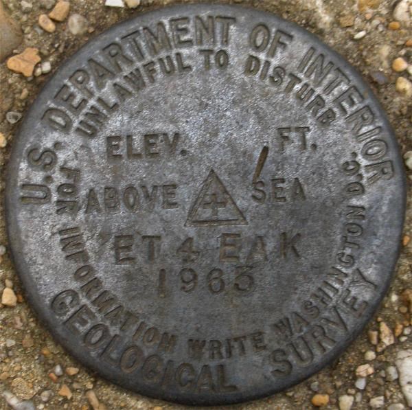
The "T" normally stands for "Traverse", "TT" means "Transit Traverse" and the "ET" is "Electronic Traverse".
28 is the series number.
For example, on the mark I found, the stamping denotes ET 4 (Electronic Traverse #4), EAK(Surveyor's Initials), 1963 (Date of Monumentation).
You can contact the USGS in Rolla, Mo. for more information on your station. All their data on bench marks is contained in filing cabinets.
~ Mitch ~
-
Mitch, Is there a reason for the date discrepancy in the DS?
HV8404 HISTORY - 1969 MONUMENTED VA-059
HV8404 HISTORY - 1977 GOOD VA-059
HV8404'STATION IS STANDARD DISK STAMPED---ET 4 EAK 1969---.
kayakbird
I believe it's simply a clerical error.
Guess I'll have to submit a NGS report on this one, but it's a pain to get to...
Back on topic:
Looking at Team MEMILA's mark, I'm guessing the setting is 7.5 inches square, just like the one I found.
~ Mitch ~
-
Blasted forum hiccup.
-
Is there a way to put all benchmarks on a map like geocaches? For instance, if I am working in a new area I'd like to quickly look at a google map to see which one that I may want to attempt. Right now it seems a bit cumbersome.
It's already been done by one of our members.
~ Mitch ~
-
You've found a USGS Triangulation/Traverse Station. Its primary purpose is horizontal control, (i.e. adjusted lat/long). You'll probably see it on a USGS topo map denoted as a triangle.
Not all USGS marks meet the NGS guidelines for inclusion in the National Geospatial Database. Why Not?
Here's a similar one I've found. It is HV8404:
Hope this answers your question,
~ Mitch ~
-
You could probably arrange it so the cache page gets by review.
The reason the guidelines prohibit advertising on cache pages is to prevent the game from being co-opted for commercial purposes. If you're placing a cache in order to bring people to your husband's business, you're really not in keeping with the intention of the guidelines.
If your husband is just generously donating some space for a cache, then keep the cache away from the sign and don't put anything about geocachers being welcome. Just place the cache and leave the business out of it.
+1
-
From what I can see in the photographs, the monument has been completely uprooted from its setting, and therefore considered destroyed.
As to why there is an inordinate amount of pink flagging wrapped around it, that's anyone's guess, but it doesn't necessarily mean its still in use.
~ Mitch ~
-
Wouldn't it make more sense to submit a report to the NGS using the same format that's given on the datasheet?
Take a short look at this thread from 2007
~ Mitch ~
-
I found one today that the USGS guys reported as a "no joy" back in 1977. I think the fence is what may have threw them off. I don't think the fence there now was the one referenced to in the 1949 description, so they may have concentrated their efforts on the wrong side of it. The measurements from the road told the true story.
Nicely done.
From the way your log is written, it appears you're getting ready to submit a recovery to the NGS.
Be sure to change the HH2 coordinates from DD MM.MMM to DD MM SS.S
~ Mitch ~
Why?
Don't they know how to convert co-ordinate formats?
The NGS (normally) doesn't edit the text file that is sent to them.
Besides, you wouldn't submit a cache using the wrong format... would you?
-
The name of the cache is something like You have made your bed now lie in it, it is in Colony Farm Community gardens IN BC Canada.You can all look it up.
What's the cache number?
If you can't answer that, I'm calling horsehockey on this one.
-
I found one today that the USGS guys reported as a "no joy" back in 1977. I think the fence is what may have threw them off. I don't think the fence there now was the one referenced to in the 1949 description, so they may have concentrated their efforts on the wrong side of it. The measurements from the road told the true story.
Nicely done.
From the way your log is written, it appears you're getting ready to submit a recovery to the NGS.
Be sure to change the HH2 coordinates from DD MM.MMM to DD MM SS.S
~ Mitch ~
-
new
in How do I...?
hi ashnikes


-
There are thousands and thousands of high accuracy points scattered across the United States.
Surveyors call them Triangulation Stations.
You can find one here. - Be sure to choose one with "adjusted" coordinates.
~ Mitch ~


Marker on ebay
in Benchmarking
Posted
Yeah... his story is such b.s. that I HAD to write him and inquire about it.
Makes you wonder if all the road signs were removed during WWII.
I'll be curious to read his reply,
~ Mitch ~