


travisl
-
Posts
1778 -
Joined
-
Last visited
Everything posted by travisl
-
Any of y'all interested in adopting cache number 107 on the current list of oldest caches in Washington? GC326A Silly Old Bear in Lakewood (south Tacoma) is one of mine, but I moved out of Lakewood two years ago and don't feel like maintaining it much longer. I got a report from an experienced cacher that it might be missing.
-
I'm cancelling the September event. It's incredibly unlikely at this point that Washington and Oregon will get to the final phases in the next five weeks. The numbers now are much, much worse than when I made the original postponement call on March 5 (indicated by the red arrows). I won't reschedule this until it's clearly a lot safer out there.


-
Sorry about that -- I thought that group was open without login. Copying and pasting here: With today's announcement that Oregon Phase 3 won't be reached until at least the end of September, it's not looking promising.
-
Very minor update, with my thoughts on what it will take to hit the rescheduled September 19 date: https://www.facebook.com/groups/PNWCacheMachines/permalink/2579276132391516
-
I've postponed it until September 19. See my announcement here: https://www.facebook.com/groups/PNWCacheMachines/permalink/2527996274186169/
-
I'm considering postponing this event due to health department recommendations against large gatherings of people. Please let me know your thoughts here: https://www.facebook.com/groups/PNWCacheMachines/permalink/2527002190952244/
-
I've got a first draft of the route ready. Take a look and let me know if I've done something odd, like making people go on a mile-long hike, ford a river, walk off a cliff, or go into a library when it's closed.
-
Note: circumstances may change after this initial posting. Look for my posts (with the icon) in this thread for all the important details and changes. If you think you've seen this all before, focus on the unique-to-this-event information in red. (Link to dinner event cache) Corvallis' tourism site mentions hiking, biking, wine tasting, theater, bird watching, craft beer, and public art. I'm sure omitting geocaching was just an oversight. So fill up the tank, grab your gear, toss down some breakfast at way-too-early o'clock, and start on the route at GC2F9D5 Greater Love IV. From there, move at your own pace and get as many as you can. Dinner will be at Woodstock's Pizza Parlor at 1045 NW Kings Blvd, N 44° 34.632 W 123° 16.488. Be there at 7:30 p.m. on Saturday, March 21, 2020. Please log your "will attends" on the event page so I can let the restaurant know how many to expect. Note that some caches on the route map may be marked with a "do not enter" icon . Those cache owners have justifiably asked for their cache to not be on the route, and for the cache to not be sought during the cache machine. The cache is, in the owner's opinion, in a sensitive area, whether it's environmentally unwise, socially sensitive, or physically fragile. Just don't get it. It's not like there's a shortage of caches in the area. Rules: 1) Follow all traffic laws, and drive safely. This is not a race; there are no winners. The only loser will be someone who gets hurt. When someone asks what you're doing, the right answer is honesty: "geocaching". 2) Respect private property, even if the cache owner didn't. Post your DNFs proudly. 3) One logbook entry for "CCM" is fine for most small and micros. Don't go filling up the logbook just because you want to mark your territory. 50 people's names and dates will fill up most one-sheets. Be kind and bring extra paper to add to caches with full logbooks. 4) As with all cache machines, if you find the cache, you'll be the one who has to re-hide it. Hide it as well as you found it. Handing it off to someone else and pointing down saying "it goes there" isn't good enough. Don't be a jerk. The extra 45 seconds isn't going to ruin your day. 5) Be gentle. Some cache containers are fragile, delicate, or weather sensitive. Take your time, double check the cache description, do it right. If you’ve already found a couple of these caches, that’s fine - give us a chance to find the cache, and then we may turn to you for a hint. Suggestions and ''Count me ins'' are welcome on the event page. ---- The Corvallis Cache Machine FAQ: When is it? Saturday, March 21, 2020. Start time is 6:45 a.m at GC2F9D5 Greater Love IV. Will it be one large group, will we be split into teams, or what? We'll start as one large group, but after a dozen caches or so, the large groups will likely fragment, and on a long day like this, you'll probably be on your own by the time most people in town are waking up. If you want to go off-route to find letterboxes, Pokémon, portals, or Starbucks, well, you do you. Is anything going on before, during, or after? An unofficial informal they-don't-know-we're-coming pre-event dinner will be at Sky High Brewing and Pub (families welcome), 160 NW Jackson Avenue, at 7:00 PM on Friday, March 20. The official event dinner is this event cache. Hey, there's a cache *right there!* Why aren't we getting that one? My standard answer here is that I try to avoid most multicaches, most puzzle caches, caches that appear to be overly time consuming, and caches that the owner has asked us to avoid. The route is built around highly-favorited caches, so some just didn't make the cut. A cache on your map shows the wrong place to park. // Hey, that road doesn't exist! // That's a long hike! // What's with making us ford the river? Thanks for catching that! Let me know, and I'll incorporate it your fix into the route. Why does the route go way past the dinner time? Is this a two-day event? The extra time is a buffer, in case you're so good that you'd run out of caches before you run out of daylight. I don't expect anyone would be able to hit all of them between sunrise and sunset. Of course, if you wanted to hit them after dinner, or on Sunday, I'm sure you'll be able to find folks to join you. It sounds fun, but I've already found some of them. Then come laugh at us, try to remember where they were, look at the old logbook signatures, or guess when we'll be at the caches you haven't hit yet. Maybe pass your phone number around for us to call when we get stumped. You have X cache on the route, but it's disabled/archived/a long hike. Let me know, and I'll remove it from the route (if archived) or may check with the owner (if disabled). X cache is in an environmentally sensitive area. // My cache is physically fragile and I don't want it broken. By all means, let me know. I don't want to send dozens of people there to stomp all over it. I disagree with the whole idea of cache machines. I don't want you finding my cache. Sorry to hear that. It's too bad you've got a neat place to show us that we won't be able to see. Let me know, and I'll remove it from the route. What's this gonna cost me? Nothing for the caching. Or, at least, nothing more than it would cost than if you did the trip solo (e.g., paying for your own gas, hotel, and dinner). I'm not collecting any money for this. Lunch? Breaks? Bathrooms? There's no breaks in cache machines! Just hold it. ? Or find something on the way. Rain? Snow? Heat? Landslides? Flooding? Rattlesnakes? Probably, yes. Do what you safely can, and skip ahead when reality or your capabilities don't match the plan. Be prepared and flexible. What do the map symbols mean? Turquoise lines show my suggested route, but if there's a brown trail or grey road that I've drawn in, ignore the turquoise. Red car icons show places to park a car for a short time (usually a trailhead).
-
One last minute update. I recommend skipping stop 88, GC2MX2Y, Chelan River Trail-Where Glaciers Clashed. In addition to the wasps mentioned earlier, it turns out that the trailhead is about half a mile from the cache. Too far for my liking.
-
The final route is ready! See you this weekend!
-
And we're live! Note: circumstances may change after this initial posting. Look for my posts (with the icon) in this thread for all the important details and changes. If you think you've seen this all before, focus on the unique-to-this-event information in red. (Link to dinner event cache) The city of Lake Chelan describes its region as one that "offers four seasons of recreation, charming shopping districts, and bountiful agriculture including an emerging wine industry." It's also got a lot of geocaches, and will be our gateway to Grand Coulee.. So fill up the tank, grab your gear, toss down some breakfast at way-too-early o'clock, and start on the route at GC2530F Kirk at work. From there, move at your own pace and get as many as you can. Dinner will be at Company Creek Pizza (they've got burgers and sandwiches, too) at 502 W. Manson Highway in Chelan, N 47° 50.640 W 120° 01.422. Be there at 7:00 p.m. on Saturday, September 21, 2019. Please log your "will attends" on the event page so I can let the restaurant know how many to expect. Note that some caches on the route map may be marked with a "do not enter" icon . Those cache owners have justifiably asked for their cache to not be on the route, and for the cache to not be sought during the cache machine. The cache is, in the owner's opinion, in a sensitive area, whether it's environmentally unwise, socially sensitive, or physically fragile. Just don't get it. It's not like there's a shortage of caches in the area. Rules: 1) Follow all traffic laws, and drive safely. This is not a race; there are no winners. The only loser will be someone who gets hurt. When someone asks what you're doing, the right answer is honesty: "geocaching". 2) Respect private property, even if the cache owner didn't. Post your DNFs proudly. 3) One logbook entry for "CCM" is fine for most small and micros. Don't go filling up the logbook just because you want to mark your territory. 50 people's names and dates will fill up most one-sheets. Be kind and bring extra paper to add to caches with full logbooks. 4) As with all cache machines, if you find the cache, you'll be the one who has to re-hide it. Hide it as well as you found it. Handing it off to someone else and pointing down saying "it goes there" isn't good enough. Don't be a jerk. The extra 45 seconds isn't going to ruin your day. 5) Be gentle. Some cache containers are fragile, delicate, or weather sensitive. Take your time, double check the cache description, do it right. If you’ve already found a couple of these caches, that’s fine - give us a chance to find the cache, and then we may turn to you for a hint. Suggestions and ''Count me ins'' are welcome on the event page. ---- The Chelan Cache Machine FAQ: When is it? Saturday, September 21, 2019. Start time is 6:00 a.m at GC2530F Kirk at work. Will it be one large group, will we be split into teams, or what? We'll start as one large group, but after a dozen caches or so, the large groups will likely fragment, and on a long day like this, you'll probably be on your own by the time most people in town are waking up. If you want to go off-route to find letterboxes, Pokémon, portals, or Starbucks, well, you do you. Is anything going on before, during, or after? An unofficial informal they-don't-know-we're-coming pre-event dinner will be at Marcela's Cocina Mexicana, 119 E Woodin Ave, at 7:00 PM on Friday, September 20. The official event dinner is this event cache. Hey, there's a cache *right there!* Why aren't we getting that one? My standard answer here is that I try to avoid most multicaches, most puzzle caches, caches that appear to be overly time consuming, and caches that the owner has asked us to avoid. The route is built around highly-favorited caches, so some just didn't make the cut. A cache on your map shows the wrong place to park. // Hey, that road doesn't exist! // That's a long hike! // What's with making us ford the river? Thanks for catching that! Let me know, and I'll incorporate it your fix into the route. Why does the route go way past the dinner time? Is this a two-day event? The extra time is a buffer, in case you're so good that you'd run out of caches before you run out of daylight. I don't expect anyone would be able to hit all of them between sunrise and sunset. Of course, if you wanted to hit them after dinner, or on Sunday, I'm sure you'll be able to find folks to join you. It sounds fun, but I've already found some of them. Then come laugh at us, try to remember where they were, look at the old logbook signatures, or guess when we'll be at the caches you haven't hit yet. Maybe pass your phone number around for us to call when we get stumped. You have X cache on the route, but it's disabled/archived/a long hike. Let me know, and I'll remove it from the route (if archived) or may check with the owner (if disabled). X cache is in an environmentally sensitive area. // My cache is physically fragile and I don't want it broken. By all means, let me know. I don't want to send dozens of people there to stomp all over it. I disagree with the whole idea of cache machines. I don't want you finding my cache. Sorry to hear that. It's too bad you've got a neat place to show us that we won't be able to see. Let me know, and I'll remove it from the route. What's this gonna cost me? Nothing for the caching. Or, at least, nothing more than it would cost than if you did the trip solo (e.g., paying for your own gas, hotel, and dinner). I'm not collecting any money for this. Lunch? Breaks? Bathrooms? There's no breaks in cache machines! Just hold it. ? Or find something on the way. Rain? Snow? Heat? Landslides? Flooding? Rattlesnakes? Probably, yes. Do what you safely can, and skip ahead when reality or your capabilities don't match the plan. Be prepared and flexible. What do the map symbols mean? Turquoise lines show my suggested route, but if there's a brown trail or grey road that I've drawn in, ignore the turquoise. Red car icons show places to park a car for a short time (usually a trailhead).
-
Please see this blog post. Questions? Follow up here or in the PNW Cache Machines Facebook group.
-
I'm so far behind in planning this one. I've not contacted a dinner spot yet, and just last week put together a draft route. Here it is. You know the routine by now -- if you know the area, or if you're ambitious, take a look and let me know what I can do to improve it. Do I have us fording the Columbia? Going to a library after hours? Entering a restricted area? Did I miss an amazing cache? Am I including a micro hidden in a pile of garbage bags? Let me know. There's no dinner location yet. Any suggestions?
-
Route updates: none. For dinner tomorrow, parties without kids should sit in the patio, so that there’s enough space for parties WITH kids to sit inside. And, fine, if you really want a route update: Stop 3, “Dot GS Trp 43758,” GC7B23G, is still disabled. Stop 5, “River Rocks,” GC7888P, may be missing, but the cache owner says it’s ok if someone wants to replace it tomorrow. Stop 44, “Sterling,” GC1T75Y, has a lot of DNFs and probably isn’t there. I probably should’ve swapped the order of stops 69 and 70. Stops 80-84 in Lord Hill Park are a longer and steeper hike than you think. Stop 89, “Freddie’s and Beyond 2,” GC88WPZ, is near a homeless camp. See you dark and early tomorrow!
-
Me, to the restaurant four days ago: “As of this morning, it looks like we have 30 people who have RSVPed their attendance for Saturday night.” My mailbox, a dozen times after that: “[LOG] Owner: XXXXXXX will attend Monroe Cache Machine Dinner (Event Cache)”. I count 18 additional attendees This will be... interesting.
-
I've just posted the final route. Any changes after this point will be announced at the pre-event dinner on Friday night and here in this forum after that dinner. Not much has changed since draft 2. I've added stop 68, Spark, and I've added some additional call-out instructions on the map (including a Lord Hill focus page), but that's about it. See you all this weekend!
-
The second draft is live: https://drive.google.com/open?id=1JB3EiUuTKtbnanbPsTbR1awhYKsRuveY Thanks, Hydnsek, PIR359, and crs98 for your desk work and legwork on this. I've made these changes (numbering is likely off due to removal, addition, and shuffling of caches): #3, Dot GS Trp 43758, is disabled but it sounds like the CO is going to have it up and running shortly. I'm moving stop 4, GCRK3V Monroe Parks: Lewis Street Park, to a later spot in the route, as it's right next to the lunch stop. Dropping 18 (Dipper Crazy), because everyone seems to think it's gone. I do, too. #19 (Sky River Sasquatch) #85 (Hoot) and #89 (This is Progress) have been maintained or found in the last few weeks, so they're staying on the route. I consolidated the trailheads for #20 (Forks of the Sky - Picnic Bend), #21 - (Forks of the Sky - Picnic Bend Trailhead), and #22 (Picnic Bend). I consolidated the trailhead for #24 (WaStatePks100: Forks of the Sky - Index Town Wall), #25 (Forks of the Sky - Blocks of Granite), and #26 (Forks of the Sky - Boulder Field) and added trail direction. Dropping 28, 29, and 30 (Shelby's, His, and Her Cache, respectively), per crs98's suggestion. Dropping 34 (Greenway), as the direction we're traveling makes crossing the highway to get it too dangerous. Adding road entrance to GC1T768 "... a snake a crystal and a beaverpond." and GC1T75Y "Sterling". I've also added: GC88GQJ Little White Church GC88WT7 Drive On In GC8841J Gold Bar GC88WPZ Freddies and Beyond 2 GC88J4V WSGA 48 North Picnic Event (!) GC88W1Q Park and Ride GC7611H Just Not Fair There's probably some other tweaks I've made and forgotten, too. This is the last draft; I'll post the final route on June 17. Still to do: I'll be contacting local prolific cache hiders this evening and into tomorrow to flush out any objections to specific caches being included.
-
The first draft of the route is up, here. I already see that I need to swap stops 4 and 5. If you see anything else I've done incorrectly, like making you ford a river, climb a glacier, go on a long hike, or drive down a non-existent road, please let me know. And if you know the area or caches in the area, I'd love to hear any other tips you'd like to share.
-
Note: circumstances may change after this initial posting. Look for my posts (with the icon) in this thread for all the important details and changes. If you think you've seen this all before, focus on the unique-to-this-event information in red. (Link to dinner event cache) Monroe: Named after the president, it's home to the Evergreen State Fair and the Monroe Corrections Center (so behave!). The Ring and its sequel were filmed here. And there's a bunch of geocaches. So fill up the tank, grab your gear, toss down some breakfast at way-too-early o'clock, and start on the route at GC876XA, Fortunate Son. From there, move at your own pace and get as many as you can. Dinner's going to be at the Route 2 Taproom, 19837 US-2, N 47° 51.552 W 121° 57.912. Kids are welcome, but parties with kids may be seated in a slightly different area of this small restaurant. Please log your "will attends" on the event page so I can let the restaurant know how many to expect. Note that some caches on the route map may be marked with a "do not enter" icon . Those cache owners have justifiably asked for their cache to not be on the route, and for the cache to not be sought during the cache machine. The cache is, in the owner's opinion, in a sensitive area, whether it's environmentally unwise, socially sensitive, or physically fragile. Just don't get it. It's not like there's a shortage of caches in the area. Rules: 1) Follow all traffic laws, and drive safely. This is not a race; there are no winners. The only loser will be someone who gets hurt. When someone asks what you're doing, the right answer is honesty: "geocaching". 2) Respect private property, even if the cache owner didn't. Post your DNFs proudly. 3) One logbook entry for "MCM" is fine for most small and micros. Don't go filling up the logbook just because you want to mark your territory. 50 people's names and dates will fill up most one-sheets. Be kind and bring extra paper to add to caches with full logbooks. 4) As with all cache machines, if you find the cache, you'll be the one who has to re-hide it. Hide it as well as you found it. Handing it off to someone else and pointing down saying "it goes there" isn't good enough. Don't be a jerk. The extra 45 seconds isn't going to ruin your day. 5) Be gentle. Some cache containers are fragile, delicate, or weather sensitive. Take your time, double check the cache description, do it right. If you’ve already found a couple of these caches, that’s fine - give us a chance to find the cache, and then we may turn to you for a hint. Suggestions and ''Count me ins'' are welcome on the event page. ---- The Monroe Cache Machine FAQ: When is it? Saturday, June 22, 2019. Start time is 5:15 a.m at GC876XA, Fortunate Son. Will it be one large group, will we be split into teams, or what? We'll start as one large group, but after a dozen caches or so, the large groups will likely fragment, and on a long day like this, you'll probably be on your own by the time most people in town are waking up. If you want to go off-route to find letterboxes, Pokémon, portals, or Starbucks, well, you do you. Is anything going on before, during, or after? An unofficial informal they-don't-know-we're-coming pre-event dinner will be at Mi Tierra, 19480 State Route 2, at 7:00 PM on Friday, June 21. The official event dinner is this event cache. There's also rumors of a lunch stop during the machine to hosted by WSGA 48N. More to come on that, if it happens. Hey, there's a cache *right there!* Why aren't we getting that one? My standard answer here is that I try to avoid most multicaches, most puzzle caches, caches that appear to be overly time consuming, and caches that the owner has asked us to avoid. The route is built around highly-favorited caches, so some just didn't make the cut. A cache on your map shows the wrong place to park. // Hey, that road doesn't exist! // That's a long hike! // What's with making us ford the river? Thanks for catching that! Let me know, and I'll incorporate it your fix into the route. Why does the route go way past the dinner time? Is this a two-day event? The extra time is a buffer, in case you're so good that you'd run out of caches before you run out of daylight. I don't expect anyone would be able to hit all of them between sunrise and sunset. Of course, if you wanted to hit them after dinner, or on Sunday, I'm sure you'll be able to find folks to join you. It sounds fun, but I've already found some of them. Then come laugh at us, try to remember where they were, look at the old logbook signatures, or guess when we'll be at the caches you haven't hit yet. Maybe pass your phone number around for us to call when we get stumped. You have X cache on the route, but it's disabled/archived/a long hike. Let me know, and I'll remove it from the route (if archived) or may check with the owner (if disabled). X cache is in an environmentally sensitive area. // My cache is physically fragile and I don't want it broken. By all means, let me know. I don't want to send dozens of people there to stomp all over it. I disagree with the whole idea of cache machines. I don't want you finding my cache. Sorry to hear that. It's too bad you've got a neat place to show us that we won't be able to see. Let me know, and I'll remove it from the route. What's this gonna cost me? Nothing for the caching. Or, at least, nothing more than it would cost than if you did the trip solo (e.g., paying for your own gas, hotel, and dinner). I'm not collecting any money for this. Lunch? Breaks? Bathrooms? There's no breaks in cache machines! Just hold it. ? Or find something on the way. Rain? Snow? Heat? Landslides? Flooding? Rattlesnakes? Probably, yes. Do what you safely can, and skip ahead when reality or your capabilities don't match the plan. Be prepared and flexible. What do the map symbols mean? Turquoise lines show my suggested route, but if there's a brown trail or grey road that I've drawn in, ignore the turquoise. Red car icons show places to park a car for a short time (usually a trailhead).
-
Updates! As learned and announced at the unofficial pre-event dinner: Stop 5, Quick Fix #1, see Jester’s navigation instructions above to save 100 feet of walking, Stop 6, Bridge Over the River Umatilla, is likely missing. I’m still planning to look for it. Stop 65, MC2, was DNFed today Stop 67, Gone with the Wind: The road to the cache is obstructed by 1) a mud hole, and 2) a stream across the road. If you have all wheel drive, sufficient clearance, and a little bit of craziness, you might make it, or you might get stuck. The Cache Menagerie says if you dare, stay to the right and don’the go up on the sloppy-smooth clay. Stops 75 (Survey Says...#6), 76 (4 Corners- Old School), 77 (It’s the cats meow), 78 (Take a Break), and 88 (Survery Says...... #7) were all DNFed today. Stop 87, Picking Up Cans, was mistakenly left on the route. It’s almost assuredly not there. I’m also told that the caches on the other side of the pass that were removed after draft 1 are still, as expected, buried in snow, but the virtual over there (Snoopers, GCA679) is do-able, if anyone wants to do it. See you in the morning!
-
Dagnabbit! I must've added it back on when I was extending the southern leg. Good catch. Satellite view shows it as a lamp post cache in the Bi-Mart parking lot. Those trees have a curbed landscaped area under them blocking a drive via 8th Street. Your approach is the way I should have mapped it, but because 8th street is a walkable approach (100 feet versus zero), I don't think that it's a distinction worth making at this point. I'm not going to update the map, but I'll certainly try to remember to navigate my driver that way :-)
-
The final route is up! There's several changes compared to the draft. Thanks to the folks I named above, and also SP&S Fan, for their help on this and three new caches for the route. Some of the changes: I've removed everything on I-84 east of Deadman Pass from the route. Now I'll have a reason to come back in warmer weather! I've added a few more in the northeast into Athena and south into Pilot Rock to keep the route roughly the same length. They're off the route. I don't mess with signed No Trespassing areas. Bridge Over and Reith stay on, the rest came off. There's been no word from the owner of Finnish and Cans. You might need them for stops 63-65 on the Umatilla reservation (Cemeteries of Umatilla County: Tutuilla Mission, Gone with the Wind, and High Water). Those look to be higher elevation, so good luck! Also, just noting here, although I've added some of the "Survery Says" series to the route, the series is incomplete. Survey Says..... #8 is reviewer-archived, as is the kinda important Survey Says..... Multi- final. The ones on the route look to be park-and-grabs and should probably be converted to traditionals. As always, how you proceed is up to you.
-
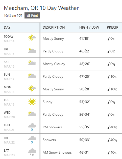
The Oregon DOT cameras at Pendleton are looking much less snow-covered today. I'm still seeing snow on the ground on the Deadman Pass and Meacham cameras, though. With this forecast... it's going to be a close call. Hopefully, we'll be able to follow others' footprints to the caches
-
Sagefox, I think I'm understanding your routing suggestions. Like this?

-
Thanks, Sagefox, Jester, and Hydnsek. As a heads up to local cachers, I've just sent out e-mails to each of the owners of 3+ caches on or near the draft route warning them that the cache machine will be rolling through, including the owners of #13 Reith Overlook (I agree that it's probably just a challenging find), #39 Abby's Hide (agreed; probably gone, and removing it makes autorouting work), and #55 Midway to Finnish and #90 Picking up Cans (same owner, curious to get their take on it). #6 Bridge Over The River Umatilla will stay on the route for now, because it looks like a pretty cool spot for an early morning visit, and there's a good chance that it's just a tricky clever hide. #53 My My Myrick is reviewer-disabled (thanks, The TC Life!) and I'll take it off the route unless that status changes.


.png)

