


Klemmer
-
Posts
1553 -
Joined
-
Last visited
Posts posted by Klemmer
-
-
Hi geosmitti:
Have you looked at the databases linked here on the Canadian Benchmarks page on Waymarking?
Klemmer
-
Have not seen the problem, thank goodness. Firefox 3.08 & Windows XP SP3.
Klem
-
Papa-Bear:
Looked at the high res. I don't think either "1" is a serif style. Hard to say for sure, but I think they could have been the same die, and they just hit the one for the "J 1" a lot harder. It is way deeper, and much wider at the bottom (but not a true serif).
Also, I stopped by there yesterday to look more closely for any sign of a location where an older disc was mounted, but didn't find any sign of an older mounting location.
I DID find that the building was built in 1906. There is a plaque on the front establishing it as a National Historic Building, constructed in 1906.
-- Klemmer
-
Here is a nice clean, sharp Flat topped BM from 1924 (DX2221 - J 1 RESET). It is set vertically on a building so it has avoided a lot of weather, although it has collected some dings. I have the high resolution version if you want it, let me know. Yours to use as you wish.
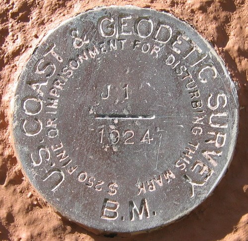
There seems to me to be a bit of confusion between the datasheet above, and DX2220 - J 1 .
The way I read it, the J 1 (DX2220) datasheet is saying that the whole building (including the benchmark!) was moved to it's present location, and re-designated as "J1 (1924)" - essentially a reset, now designated in the NGS database as "J 1 RESET", which is DX2221. Quite possibly DX2220 - J 1 should be destroyed in the database. There is clearly no old building at the DX2220 described location.
However, there is at least one loose end: in the DX2220 log entry of 1927: the B.M. is referred to as J 1 (1906). Possibly the datasheet monumentation date for DX2220 - J 1 is wrong, and should have been 1906. If so, and the while building (and disc) was moved, then why is the disc stamped 1924? I'm not far away, and can go by J 1 RESET (DX2221) again if needed. If it there used to be a 1906 disc, too bad it wasn't retained. Would have been an interesting disc (cup type?). Maybe it was destroyed in the building move, and the 1924 disc monumented then (1924? 1927?). I may contact the Chapman College facility management or history departments to see if they can clarify.
Any thoughts? Suggestions?
-
I own several Garmins, a Magellan, and a Delorme PN-20 and PN-40. Lately, every time I head out hiking, geocaching or benchmark hunting, I have the PN-40 on my belt. I guess I'm just a Delorme "fanboy". I have my choice, I chose. I'm quite happy with it. It's mostly about the maps, for me. Your results may vary. To each his own.
-
I assume UNK1 is talking about whether they would qualify for the contest. He's the boss for the contest. And I agree.
My more general opinion:
For GC logging purposes, it is really up to you. You logs look OK to me. I assume all the nearby landmarks matched.
For NGS logging purposes, here is the guidance we have received from the NGS in the past for missing disks, with the stem only remaining:
1) Vertical Control (which would normally be Scaled location): Not Found
2) Horizontal Control (which would normally be Adjusted location): Found Poor
In both cases, describe the situation found. And be REALLY sure you have the right "stem".
-
Bill(s):
Oh, no, I didn't mean you shouldn't try it. Sorry if it sounded that way. I was just trying to point out some of the pitfalls and other issues. Try away! I've been thinking of trying some long period averaging myself, which is why I gave the concept some thought. But, I don't really have a practical way to do it, that I have figured out yet.
Larry
(Klemmer)
-
Bills (both!):
I'm not a math expert, nor the best GPS expert on the forum, but:
1) I'm reasonably sure the GPS HDOP "variation" is not completely random. It is tied to all sorts of physical phenomena (day/night, ionospheric variations, clock and orbital variations of 20+ sats, etc), each with it's own time cycle.
2) Your "averaging" methods all assume (or depend on, or are designed to work) on variation that is random.
3) At best, I think that a very long term average will eventually converge on a composite of the various physical phenomena cycles, possible with an underlying random noise floor.
There is a reason survey grade GPS receiving "systems" (including off-line NGS corrections, etc) go through all sorts of wickets to correct the collected data. It would be nice if a long term average of a consumer grade GPSr would result in a "really good" position. But - I don't think it will happen. A little better, sure. Worth 10 minutes when placing a cache, or maybe 30 minutes before digging for a triangulation station. But I wouldn't expect huge improvements. Just my opinion / experience.
Larry
(Klemmer)
-
A couple more today:
DX3486 (S 1329) - Setting 48 - first of setting - 10 points
DX3298 (T 779) - Setting 7 - not first of setting + pre-1960 bonus = 6 points
-
Yes, Klemmer has a Delorme PN-40, and is very happy with it.
-
First to log? Wow! I'm just going to log as I go along, and not try to juggle potential logs for bonus points. I'm in for the push to get me out there. Points not too important for me. To each his own. Best of luck to all!
DX4813 -- Setting #7 -- 10 points -- first for setting #7 -- [Note: NGS datasheet used for setting, GC too old]
AB8571 -- Setting #30 -- 10 points -- first for setting #30
AB8572 -- Setting #34 -- 10 points -- first for setting #34
-
Sheesh! I was just kidding! They really are like stardates? Can't be that easy, can it?
-
Maybe they are like Stardates?
-
Thanks for the pics. I had no clue what a wig-wag was!
-
Bismuth:
The Magellan MobileMapper Series are much more expensive ($2500+) semi-professional unit, sold by a different division of Magellan, also still being made (my daughter's company just bought one for her work in wilderness parks). It bears a superficial external resemblance to the Magellan Meridian Series, but are quite different electronically. I guess Magellan can't get away with stiffing their "professional" level customers like they did to their consumer customers.
BTW: I like your very elemental geo-name.
-
On my Delorme PN-40, I just change the icon when the benchmarks are in Topo USA to whatever I want (red pushpin usually, then green for found). No problemo. I can get a count for each, if I want.
-
Me either, and I'm in Las Vegas today, and could probably find a way to actually place a bet on it!

Seriously, chances are almost zero. In the geocaching.com folk's mind, the Waymarking website was created to eliminate the need for updates to the benchmark section database (as well as for some other reasons). I know it doesn't make sense (to us).
-
Simple explanation:
The adjustment in the published Lat / Long for a benchmark like this one is done by calculation. Finding the actual benchmark is not required. The position (original or the latest adjusted one) is still way better than our consumer grade GPS receivers.
Good question. Answers OK?
-
And:
Have you noticed that the person setting the mark was A.D. Bache. ??
He was one of the early pioneers of the Coast Survey (second director, appointed in 1843), and the great-grandson of Benjamin Franklin. The link above is to a quite lengthy profile, and I confess I only scanned it for the Survey references. Here is bit more concise history of his work. Really interesting mark(s). Wish I was closer (well, sometimes.....).
-
Cool! Nice to have the right tools when you need them. Thanks.
-
Papa Bear:
How "close" were they in 1850 to the current GPS position? Or is that too difficult to answer with all the different "datums" in the years between?
-
Oh well, I wrote a macro anyway, before I saw AZ's post above. I didn't think of that method before. My macro might be easier / quicker. Depends on your preferences, I guess.
[edited after I figured out what AZ meant, and tried it]
-
Hi Benchmark Hunters:
Getting ready for the Benchmark "Settings" contest, I wrote a GSAK Macro to pull the SETTING data out of the datasheet description, and put it into the User Data column. The benchmark data in GSAK is normally stored in the "Long Description" location. this has been tested with a fresh download from NGS, and the latest versionof GSAK (ver 7.5.1.28). The conversion from the NGS .dat to the .gpx file (to load into GSAK) can be done with either the the original BMGPX program, or the newer NGS>>GPS program. Both seem to work OK.
Here are some quick instructions
- Modify your GSAK display to show the User Data column in the "View - Add/Delete Columns" menu
- Copy the macro to your "C:\program files\GSAK\macros" directory (or as required)
- Open up your GSAK benchmarks database to modify [you can set a filter if desired]
- Go to the "Macro - Run/Manage" menu
- Install the macro
- If you have something in the User Data column, I recommend running the "Clear UserData" macro
- [if there is something you need in User Data, you are on your own, and can modifythe macro as needed]
- Run the "Setting to UserData" macro
You should end up with 'SETTING: XX" in the User Data column.
Note that intersection stations do not have a SETTING line, and User Data will be blank
In addition, in several counties I have looked at, other marks (including some Triangulation Station Discs!) do not have SETTING entries. They will be blank also. You can now sort the User Data column by SETTING.
If you don't like the results, or after the contest, or when you want to use the User Data column for something else, just run the "Clear UserData" macro.
The macros are posted over on the GSAK forum HERE
To download the macro from the GSAK forum, I recommend you right click on the download link, then select "Save Link as...", and save it to your "C:\Program Files\GSAK/macros" directory.
- Modify your GSAK display to show the User Data column in the "View - Add/Delete Columns" menu
-
I'm in, with no snow to worry about (but plenty of rain at the moment!).
For benchmark hunting, it's just Klemmer. TeddyBearMama thinks it's silly (or some such...), so save your database electrons & column space, and just make it "Klemmer" on the scoreboard.

Scaled Marks: Why Do We Bother With Them?
in Benchmarking
Posted
Simple answer:
The "Scaled Marks" you are talking about are very, very accurate in elevation, but not in position.
The "Adjusted Marks" you are talking about are very, very accurate in position, but not in elevation.
Very rarely you will find marks that are accurate in both elevation & position. These are becoming more common with the advent of GPS.
P.S. It took me a while (some years ago) to wrap my head around the differences. Don't feel alone.