

Klemmer
-
Posts
1553 -
Joined
-
Last visited
Posts posted by Klemmer
-
-
Jackie:
If you enjoyed that mark, imagine finding one you WERE looking for! Using the same search method, look for some around your home area, and go find some! be sure you understand the basic difference between SCALED (not GPS accurate) and ADJUSTED (MORE accurate than your GPS. You mentioned you read the FAQ, and that's a real good start.
Good luck!
Klemmer
-
So many great pictures in here! Wow!
I love to take tons of pictures while hiking / benchmark hunting / geocaching. Some of my favorite targets are wildflowers and wild critters. Now that I have somewhere to brag on them, I could post a couple hundred...... but I better not, here. Sample below, and I'm working on selecting a bunch more good ones for posting on our family picture site, and I'll post a link here then.
Meanwhile, probably my favorite target in coastal California is the Cat's Ear (Calochortus plummerae), also known as the Mariposa Lily (in this case, Plummer's mariposa lily). Not very common (rated "rare" in most flower guide books). You can usually find some in the SoCal coastal hills in late spring. Colors vary from pure white thru various shades tinged or edged in purple / violet, through this full colored purple specimen. Got to love all those little hairs inside!

-
Brian:
This the one you want?
Don't forget, you need to have the Geocaching add-on for "Send to PN-40" installed. The files are used.
Klemmer
-
I've had a combination of 950 (left room for field additions) geocaches and benchmarks, with the full "up to 15,000 character" descriptions. Haven't hit a memory the limit yet, if there is one. BUT - I do have the PN-40SE with 8GB internal memory, with (typically) more than 2 or 3 GB internal memory free. I also normally have another 8GB SD in it with more maps & aerials (but I doubt caches or waypoints could go there...).
-
I'm with AZcachemeister. I've used two different Palms (Tungsten T3 most recently) with Cachemate. Like he said, all the data is there. Been using it for years (about 5, I think), and have no issues. Although I rarely bother, the T3 can rotate the whole screen (into landscape mode), and then the box scores are on one line per mark, like they should be (no wrap). Try that, if your PDA can do it. Maybe you'll like that.
-
Excellent! Nice summary.
-
Related to dixiedawn's picture, here's one picture I DIDN'T take, but it gives you an idea of a FEW of the survey marks on & near the Hoover Dam. These are just the key Triangulation stations. The ones southwesterly of the dam (connected by red lines) are on interesting triangular pylon monuments. Several are in view in dixiedawn's picture. Almost every mark has been incorrectly logged at one time or another on GC. If you ever get a chance, load up the marks on your GPS & PDA & go to it! Take lots of camera memory with you. Something like 70+ on & near the dam, but many not publicly accessible.

-
Look forward to reading it when it's done. Always enjoy your educational ways to share your expertise, George. Thanks. Be sure to post a link for us when it's ready for "prime time".
-
Here is a great classic Beech 3NM floatplane I saw just off the Colorado River after finding EU0763 (refuge):
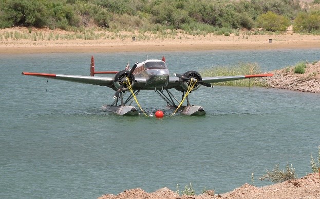
Another closer view:
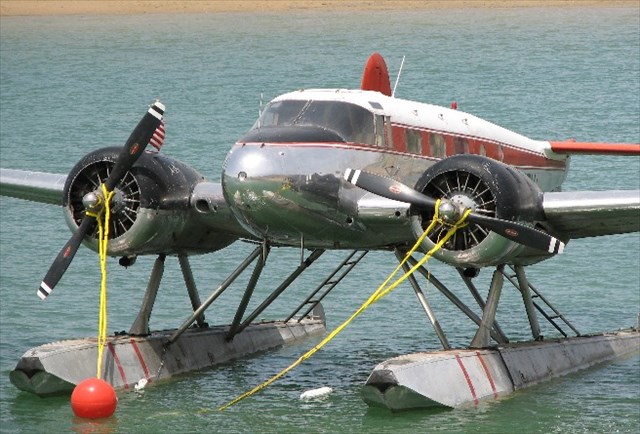
There are a few more pictures and details on the EU0763 benchmark page.
Don't you love the way they tie the dock lines to the props? I was surprised, but it does make sense. If there was some serious wind (the main concern), you wouldn't want the dock lines on the floats, which could end up ripped off the fuselage. Tied down by the props, that plane isn't going anywhere!
-
Ooops! Didn't realize the disk had already been mentioned on this thread. Sorry!
-
United States Engineers "evolved" into the US Army Corps of Engineers (as I understand it, and keeping it simple). There are lots of dams where I often hike, and I keep tripping (at least once literally) over the survey markers from the Corps. Several years ago, I tracked down an appropriate person & sent them an email, asking about an on-line database. Nope. None (at that time), nor plans to create one. If you are a surveyor, and need the data, they will send you the data on a marker.
-
Hi Team-Bee:
Welcome to benchmark hunting! As Bill said, there are many benchmarks out there that are not in databases that we have access to, if they are in any at all.
Here are some places you can learn about survey markers (benchmarks):
Me First (at the top of this forum)
Benchmark info on Geocaching (slide down the page for lots of info)
Unless you just happen to stumble on one, most folks who enjoy finding benchmarks start with a database (geocaching is one), and go try to find the benchmark based on that.
Good luck!
Klemmer
-
Hi George:
I don't want to scoop TheBeanTeam, but when looking at one of their recent logs, I think this disk might be of interest to you. Flat, and maybe a little unusual (US C&GS 1917 magnetic station).
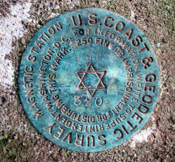
More pictures of theirs on the log page: QE0491
Nice find & pictures, Beans!
-- Klemmer
-
Does your friend know the term "Customer Support"? Magellan doesn't. Worst I have ever seen or heard of.
-
Once you have the .gpx file, GSAK or other software can easily tranlate it into a .pdb file for Cachemate, and you can have an almost unlimted number of datasheets on a Palm OS PDA. I have 20,000+ datasheets typically on mine (most of SoCal, by counties), on just a 1GB SD card w/ room left, no delays sorting, etc. Great.
OR: Delorme PN-40 GPS now takes up to 15,000 characters per "cache" from a .gpx file (for the moment, using 3rd party website based "hack"). Up to 1000 "caches" in theory (there may be a memory limit, but with the 8GB internal in my PN-40SE, so far OK). The GPS thinks the datasheets are caches, but all the data is there, except for the really long datasheets. Slow loading at the moment, but a (faster?) direct from Delorme loader coming "soon". You can nap while 500 load. Doing it from Topo USA 7 still only gets you 800 characters per datasheet, not enough for most Benchmarks. Version 8 promised soon should do all 15,000 characters. At 15,000 characters per BM, pretty good load of "in the GPS" datasheets.
Curious: How many / how large each datasheets from a .gpx can you get onto a Oregon 400t? Maybe I should look at one....
-
How about earthquakes special credit? I was out hiking / caching (OK, not BM hunting that day) when a measly 3.8 hit, but I was about 2 miles from the epicenter! THAT got my attention! Shheesh!
-
Papa-Bear:
I agree. I've never seen scaled marks with that precision on NGS before. Something new and.... ummm.... possibly misleading? Seeing that level of precision on scaled marks is just weird.
-
jwahl:
Interesting stuff. Thanks!
Maybe the Desert News should publish a "correction" or at least a re-visit of the issue with the proper information. And, you are just the guy to do it! Go for it!
-
Looks like 1883 to me! UNK?
-
Hi Patty:
I believe that is correct. Read down about 8 more lines:
HN0794.The NAVD 88 height was computed by applying the VERTCON shift value to
HN0794.the NGVD 29 height (displayed under SUPERSEDED SURVEY CONTROL.)
So, I believe the VERTCON software was used to convert the mark elevation from the older NGVD29 vertical datum to the newer NAVD88 vertical datum.
That has been my interpretation of this datasheet entry previously. But if I'm not right, someone else will jump in here, I'm sure.
Klem
-
BDT is right, we are a little stuck with what we have. As he said, there were some long threads several years ago, discussing pros & cons in painful detail. In trying to walk a middle line & simplify (especially for relative new comers), I sometime use "mark" as a generic term (see my post above). Could be a Bench Mark, or could be a Station Mark. Or, even reference Mark or Azimuth Mark. Works, doesn't it?
-
I'm with Papa-Bear.
- Get close (if you can), and use the macro focus setting. Zoom if you can't get close.
- Take full resolution [8 MegaPixels (MP) most recently]
- Rotate
- Crop as required
- Resize to about 600 pixels (square for discs, about 700 pixels longest dimension for non-square)
- Adjust compression so that file size is about 125KB (+/-10KB or so)
- If compression in order to get file size down to the desired range gets below about 85 or so, I re-think the cropping & re-sizing operations above
I'm generally happy with the above results. My favorite software for all the above, for many years, which makes it easy: ThumbsPlus
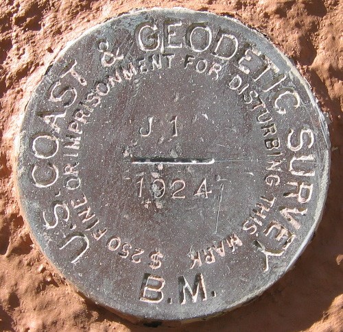
Recent example:
Guess I'll try Papa-Bear's advice & bump up the files size to 150KB max, and see if GC leaves it alone. Thanks!
- Get close (if you can), and use the macro focus setting. Zoom if you can't get close.
-
I'm in agreement with the last 3 posts. Seen some similar stuff done out here, and worse (PVC pipes!)
If anyone is really interested in determining exactly what the material is, Chemir Analytical Labs did a great job for my company recently in exactly identifying some contaminating material of unknown origin inside one of our products. Good company, good work, quite pricey ($3,000+).


(no financial relationship to Klemmer)

Your Best/Favorite Benchmarking pictures.
in Benchmarking
Posted
Oooh... we're doing snakes, too? This big boy (Red Diamond Rattlesake - Crotalus Ruber) was watching me from the side of the trail up to DX4661 (which is a story of it's own). He never did rattle at me (BTW: taken with about a 10X zoom lens!). Not much in the pic for scale, but the number of rattles is a good clue. The lump in the middle (wrist sized) might be why he was quiet.
If you like snakes, here's my collection of snake pics.