

Klemmer
-
Posts
1553 -
Joined
-
Last visited
Posts posted by Klemmer
-
-
Awesome! Please keep us posted (pardon the pun!).
-
You bet! Always carry several maps / charts, both paper & electronic varieties. For the overview & detailed streets, I find the Thomas Bros book useful. Also, just recently, got the new Jeep with built-in GPS. Great for the "go to" function. Also just got the Magellan Meridian mounted near the dash so I can see it also while driving. It has the Mapsend topos built-in, and of course the Benchmark locations. Sometimes, especially for the 5+ mile "hike to" benchmarks (and geocaches), I'll also print up (usually on waterproof Adventure Paper), from Delorme TopoQuads, a topo portion with route & targets on it.
I must say, I tend to overdo the paper & electronic maps. For me, it's part of the enjoyment of the hobby (benchmarks & caches). I'm also a pilot, so having the all the right charts seems normal & good!
"Maps / charts" terminology: Yeah, technically, if it has Lat/ Long, it is a chart. But try asking for the chart section at a bookstore or sporting goods store. Good luck, even though many of them on the rack will in fact be charts. Sort of depends who you are talking to. Even many pilots call them maps. Hmmm.... Used to be the Defense Mapping Agency. Then it was National Imagery and Mapping Agency. Not anymore. Now it is part of the National Geospatial-Intelligence Agency (NGA) . No more Mapping in it's name. Not charting either. Now it's all Geospatial-Intelligence. Funny, though, their URL is still NIMA (but http://www.nga.mil also works). Huh. So - I always have some Geospatial-Intelligence with me!!!!

-
Dgps
in Benchmarking
Used to have DGPS on our 35 ft salt water sport fisher before we sold it. Worked well, with 50 mi or so of the station (USCG Nav beacon, Long Beach CA). Got us into port on a darn foggy morning. These days:
WAAS = DGPS
WAAS is available in and near the entire US. Europe has a system in process also.
Aircraft using WAAS also.
I would guess that the USCG is at least looking into (or maybe has) killed the DGPS on their Nav Beacons, and maybe the beacons(?).
-
Thanks again for the great info, evenfall, as always.
This thread brings to mind the time I stopped to talk to a survey guy in the Disney Resort area (CA, the REAL one!). He was actually just outside Disneyland, on resort property. He was wearing one of the Trimble backpack setups, with a good size antenna on a mast over his head. All man portable (no tripods, etc.). He would back up next to a tree (antenna next to trunk), wait about 2 - 3 minutes, save the data, go to the next one, etc. It was summer, lots of leaves on the trees. We talked for a while, as he worked his way down the block. Turns out he was getting "accurate" data (he said with an inch or two) on each tree larger than about 6" circumference, for the Disney landscape department. So now they know where all their trees are, give or take a few inches! Interesting application of GPS!
-
One small addition: somehere in a thread here, it was posted (by a knowledgeable power company employee) that pole or tower numbers are often kept the same, even if it is repaced. So, just because it has the same number, I guess you can't assume it is really the same tower. As evenfall said, the owner is the best authority on it.
-
Hi Eaglehaslanded! Love the name.
For purposes of Gecaching.com, and also the NGS, the most important thing is the main station disk (in this case, the triangulation disk). It will have a triangle on it. I suppose you know that the Reference Marks (like RM2 you found) have an arrow pointing to the main station disk. It is always good to mention the RM's and azimuth marks you found or didn't find in the report. In your case, I think most of us would agree that a note in appropriate, explaining what you found or didn't find.
You can learn about logging with NGS in the variuous forums and FAQ's. The "rules" for the NGS are a little different. This HERE is probably a good pace to start.
Good luck!
-
Only 68 benchmarks FINDS so far. Working on getting them into NGS (when appropriate). Still working on finding more!! Be aware that the "benchmarks" number on GC.com is FINDS only! The holoscenes site above (which by the way is great!) is counting NGS REPORTS (Find and Not Found), except Destroyed reports (as explained on the site FAQ). I wish GC.com counted Not Founds. I would have another 60 - 80 or so!
Also have 468 geocaches.
-
Only Wisconsin so far? What about the "left coast". We have LOTS in California!

But probably none of Governator Arnold's money to spend
-
IF THERE ARE "DASHES" TRY IT ALSO WITH SPACES REPLACING THE DASHES. WORKS SOMETIMES. ALSO TRY IT WITH NO SPACES OR DASHES.
-
Huh - looking at the Epicenter cache location, I had a thought: If there were another 500K or so people in SW NY (like maybe Jamestown NY), would the population center fall outside the state? I think it might be mathamatically / geometrically possible (?) Is there any state where that IS true? Or might be someday.... Maybe Florida? Needs to be sort of "U" shaped.....
[slow night at the computer....]


-
Ngs
in Benchmarking
Backdoor working now (1:45pm PST). Thanks for the backdoor, Paul! (I knocked)
Front Door not working at all. Strange.
Correction - Backdoor gets you the menu today, but when actually trying to use it - no go! Darn.
I guess we stressed it out with too many recovery (and not found) reports, and we broke it! Sorry, NGS!!!
[just kidding - I'm sure it's temporary, and it IS a holiday weekend!]
-
I have the Platinum and love it. Yeah, you don't REALLY need the built-in compass, but it sure IS HANDY! You don't have to be moving to get a proper bearing to the cache. You can stand still, turn around, and the needle points to the cache. I had a simpler GPSr before (Garmin Etrex Venturew) without the built-in compass. I LIKE the Platinum compass. IF you can afford it, it IS useful. The choice is still yours. Money or convenience.
The barometer is useless. It is NOT an altimeter. It gives you barometric pressure only. BFD. No altitude. Magellan missed the boat on it.
-
So PFF, some marks were submerged? You let that stop you? What about Scuba gear? Wouldn't that make them tidal stations?


-
If you are interested in the situation on virtuals, here is a LINK to a recent discussion of their existance (or extinction) on our local SoCal forum. If you read it, keep in mind that "FullOn" is the local (S.CA) Geocaching.com approver (and by the way, a very nice & reasonable guy).
As the owner of several "grandfathered" virtuals (at Disneyland & environs), I'm kind of discouraged also, but as they say, you can't fight city hall (or in this case GC.com).
-
Well said. Thanks, Rob. I sorta knew that in general terms, but you said it so well! You write for a living?
-
The US Department of Defense (and other similar organizations worlwide), as well as NASA, have spent many millions of dollars mapping the gravity variations worldwide. It is necessary to know this information for accurate orbital calculations. In fact, even the GPS constellation of satellites needs it! GPS would be useless if the control system didn't know the exact gravity data worldwide, since it effects the orbits. NGS data was fed to NASA, DOD and others. May still be, but it's not something that doesn't change much, as I understand it, barring major rapid earth movements (i.e. earthquakes). All part of mapping, just a different part.
-
The C-language source code for BMGPX is available HERE. All you need now is someone to compile it into an executable on a MAC system. Maybe someone has already done that? Try emailing the BMGPX author at the above site. I think he is on GC.com as parkrrrr also (or was). Once you have the .GPX file I believe there are several different solutions to get it to the Palm.
Of course, if GC.com would come up with PocketQueries for Benchmarks, this problem would go away.
By the way, as this will be a one-time conversion (or maybe several counties), is Virtual PC that bad? Not like you need to do it very often. Luckily, benchmarks don't change much (on our level of use).
I suppose, for a county or two, given a week to work it in, I could do the conversion for you on my PC. I don't want to make a career out of it, but few would be OK. The result will be a .pdb file that will be compatible with Cachemate on the Palm. Cachemate is $8, and VERY well worth it. If you have a .pdb file, can you load it ("HotSync") it from your MAC to your Palm? Software for that should have come with the Palm, or at least be on the Palm website, of course for your MAC. Depending on the county, the file size might get a little large. You will need a big enough email box. I can give some examples for ones I have done if you are interested (Palm not with me at the moment at work). Counties vary a lot in size / benchmark population. Memory expansion (SD card?) might be needed for the Palm. I think I have 5 large counties of SoCal in my 512MB expansion card now, maybe about 15,000 benchmarks. Cachemate handles them just fine. I could get you the full NGS datasheet of any mark on my Palm Tungsten T3 in under about 30 seconds. Easy to read (except you do need a little shade, a hand or something is enough).
-
Jerry:
Thanks for the input. Makes sense. That is also very close to my "mystery mark". See my first post for it's position (by handheld GPS):
N33° 50.823'
W117° 38.880'
Which in Jerry's terms (I believe he is talking minute & seconds) is:
N33° 50' 49.38"
W117° 38' 52.8"
(where ' = minutes, " = seconds)
I think with the potential inaccuracies in my handheld position, and Jerry's estimates, they are within each other's error range.
All the more reason that undocumented mark mark 3R-78-71 is looking like (or very close to) the "so far missing" Azimuth mark.
-
Have you looked into Cachemate? I have used several different ways to get complete NGS datasheets (lots of them) into my Palm. Sorry, I don't know about MAC support, but I guess Palm must provide a utility to load the .pdb file to the Palm.
[signed - nonMAC dumb PC'er, just trying to help]
-
Thanks mloser. Yep, it's a porcupine! A big one. Been seeing it from down in the valleys for years. Didn't see any cairn, but also wasn't looking for one. Yes, it is 95% probable you could shoot an angle to / from my mystery mark to the station. Certainly no terrain in between. My only concern is that there is a slight possibility that one of the radio "shacks" is in the way. Don't think so, but.... real hard to tell just by eye from what I have here / remember. The azimuth I measured on the map at the beginning of this thread is probably more acurate than an azimuth I could shoot with a handheld compass. It is laid exactly on top of the two Lat/Long coords (one very accurate from AA7647, one is from my handheld GPS at the mystery mark). My GPS (Magellan Meridian Plainum) has a built in electronic compass, and if set right, will read out True auto corrected for magnetic variation(s). It uses the right variation based on where you are. Neat.
I'll get up there again sometime.
-
Thanks, mloser. No, the Mystery Mark was NOT in a boulder. Good question. It was in a small concrete pad:
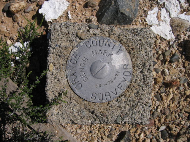
Mystery Mark
That IS significant. Thanks.
Yep, there are a BUNCH of radio masts up there. Here's a pic from a nearby hill, where we placed Bowling for Copters, one of the four new caches we left up there. RM4 was in the foundation of one of the masts. I GUESS it is the mast in question, but it is a little hard to tell for sure. I don't think I will log it as found until I'm more sure. Another reason to go back!
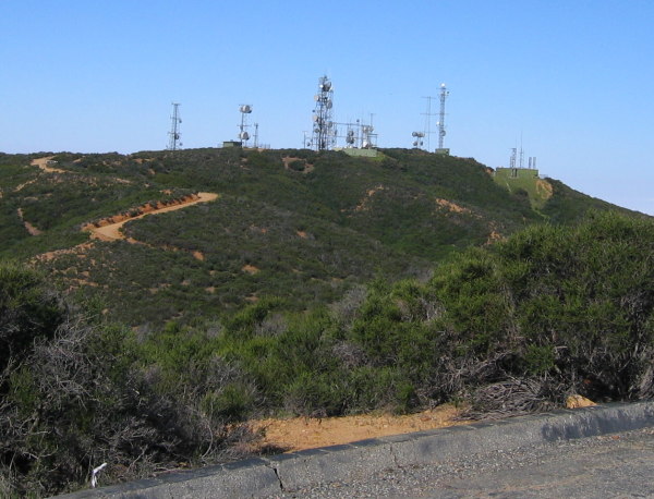
Sierra Peak from a nearby hill
Interestingly, both the 1933 and 1958 descrciptions are for the same azimuth line from the station (within 1933 accuracy)! Sier Reset (AA7647) has the Geodetic Azimuth (I believe this esssentially a True bearing) at 122°10'45.5". The old 1933 Sier (DX2175) has it as S 57 DEG 47 MIN E. That is, 57 DEG 47 MIN EAST OF SOUTH, which is equal to Geodetic Azimuth 122 DEG 13 MIN!!!! [180 DEG MINUS 57 DEG 47 MIN]. They agree within about a minute and a half. Maybe as close as 1933 accuracy, but might also be due to a datum changes ("adjustments")?
The saga continues.....
-
mloser: Thanks for your topo confirming words.
I too would like some info from the experts on eccentric marks. Didn't know what the "ECC'" was until your post! Use, reason, etc. Since they were not mentioned on the triangulation station datasheet, I didn't look for them.
As far as 122° vs 123° to the "azimuth" mark, remember that the "mystery marker" my estimated 123° azimuth goes to n unknown mark, that there is no datasheet for it, so the Lat / Long is from my handheld GPS. I feel pretty confident that the 1° difference is easily attrributable to that likely error.
For some reason I didn't know about the intersection (tower) marks when I was up there. I need to figure out why that was.... RM4 was found where is was supposed to be, so I suppose the tower is also, but I'm not sure....
Guess I'll just have to go back! Quite a hike, but I can always use the exercise.
-
BuckBrooke: Thanks for your interest (I do mean that), but you are mis-interpreting the Topo. It is easy to do, even sometimes if you have been looking at them for years. Having a small section makes it more difficult to visualize correctly. There is a LARGE peak at the top left (triangle symbol), tallest in the area. The straight red line runs from the peak down to the SE (to the bottom right), and ends on a small hill / ridge, just east of the road. In between (where the jagged label line points) is a VALLLEY (notice the blue-green water symbol starting just south of the straight red line?). Sorry, it is not a north-south ridge. Anything down in the valley would likely not be visible from the peak (triangulation station). You are having a bit of an "optical illusion" problem with the topo. The mystery mark IS visible from the peak (or a minimum 3 foot tall pole would be, to get above the scrub brush). Trust me. Wish I had taken more pictures.
-
"Adjusted" means the Lat / Long is very accurate (better than our handheld GPS units).
"Scaled" may be off by as much as 600 feet. Use the text description for ones that are noted as "Scaled".
You might want to browse the
Frequently Asked Questions here, for example:
Why do the coordinates of some benchmarks seem to be way off?


Ngs Faq Draft
in Benchmarking
Posted
Now I remember why I stopped reading all the GC forums except Benchmarks & NGS. Lighten up, guys! Both of you.