


billwallace
-
Posts
307 -
Joined
-
Last visited
Posts posted by billwallace
-
-
They definitely did that around here - so far (my recoveries) it has been very easy to see why/how they chose the station designations.
CA-DOT seems to have used this also - typically using the landowners name.
Thnx for the extracts, keep-em-coming

-
Before your range, both with a single slash, NOT crossed:
hmm.. from Ventura county to Monterey county (Ca) there are only a couple in the late 50's to early 60's that are not DNF'd.
How can you tell if a station was originally set as a tidal bench mark? Could a station that was originally a vertical control be adopted as a tidal bench mark? For example EW3748 does not have tidal in the designation but the datasheet says it is a tidal bench mark.
-
how about this...
I like Geocaching with my family (kids mostly) but not by myself
I like benchmarking by myself - haven't had the opportunity to coerce someone into a benchmark hunt so I don't know about that yet

-
I'm in - Depending on the timing and circumstances of course........ Are people still interested....?
-
In my limited experience - I have to say that anyday benchmarking that takes me someplace I haven't been to (or haven't visited in a looong time) is a good day which so far has been every day (yeay!!
 ). But for whatever reasons (i haven't tried to figure out) I particularly like marks in rock outcrops, marks in high places and marks that take an effort to get to - and, oh yea, did I mention RR tracks and trestles and bridges?(used to play on them as a kid).
I guess a couple stand out:
One of my first days out I picked a bunch of bench marks that happened to follow a series of interconnecting back-country (county) roads. I found quite a few that day and they were all fairly old (1957) and in parts of the county I hadn't been to with some awesome scenery and views. It was interesting that all the road names had changed but were still there and easily identifiable on current maps from the descriptions and locations on the datasheets I started noticing that the station designations were all similar and when I got home learned about leveling runs and NGS project searches and other such cool stuff. That was a good day.
The other was the day I found a couple of marks that had been originally set in the late 1800's and had disks added later - but the reference marks were the original lead plug with copper tacks in drill holes (cool). These were on parts of the coast I hadn't been to. Red Rock
One of them I originally didn't find but went back to at the end of the day and did find it - There are actually two stations here with interwoven reference marks and the datasheets were confusing me and I still have to go back there 'cause I still didn't find all the RMs
And perhaps the VERY BEST day will be the next one.
-
Or maybe even a technicianA benchmark hunter is like a geocacher, but with the soul of an engineer.

-
The Internet Archive's Wayback Machine took a snapshot of Buckner Creel's site in August 2007.
There may be some material of interest there.
-ArtMan-
Cool, I started clicking links from the archived site and ran across this PID prefix map showing the US grided off with PID prefixes - There was a thread somewhere in here wondering if there was any rhyme or reason to those prefixes. For my area it seems to match the majority (88%) of PIDs.
-
My prize came yesterday - YEAY!! - Thanks again to everyone that helped run it. I haven't been out since my last contest run partly because I can't decide which one's to go get next so I guess the contest helped me focus my interest
. I think I will continue to try and pick up the rest of the settings I missed in California and at some point look for the elusive setting #57. It seemed at times that the setting type listed in the datasheets were a bit arbitrary but one of my favorites (setting-wise) was this benchmark on a church - I wonder if the surveyor intended a double meaning when that setting type was chosen. 
The prize is great - it's the one I wanted
so i had to be real careful and not get too many points but keep my eyes on TillaMurphs there at the end with those 250+ point posts. The citation was a nice touch - In my case Luck and Time would be at the top of the attribute list. -
It is certainly not geodetic. And this from the category description....I think this would be somewhat like wanting to waymark a tripod.This category is fairly strictly limited....for fear that too many marks that may appear to be geodetic marks, but are not, might otherwise be included.
Yeay Shirley - u makea my face laffSo....It sounds like it is 'Pillar Time'.Forgot about Flickr - here are some pix.
-
When I scrolled down and saw that picture my first thought was "hey! how did they get MY picture in that post??!!"Aha! here is the one at Silverwood Lake:I think you are right, I'll submit it over there and see what happens.
So... I was looking at some of jwahl's references - does the instrument just sit on top of these piers not actually attach to it?
thnx all
-
For the 2009 Settings contest I took a trip down to Los Angeles. On the way back I stopped at Pyramid Lake to relax and NOT hunt benchmarks.
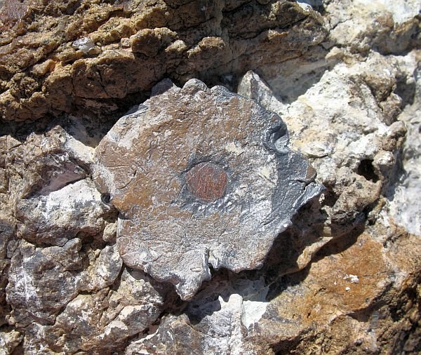
 However I ran across what looked like an instrument mount (tribrack?).
It is a tapered cylinder about 4 feet tall with a metal disc on top. The disc is about 10" across with three radial grooves at 120 degrees each. There is a 1/2" diameter threaded stud protruding from the center (only about four or five threads showing). Sorry about the description but I don't have a permanent place to post the pix (yet). Anyway it is extremely similar to the first pix posted by dixiedawn in the What is this marker? thread.
I wanted to post it at Waymarking-dot-com and it doesn't really seem to fit the Benchmark category. Any Suggestions? (my first post at the Waymarking forum so I double posted here - 'sallright?)
I've never seen a theodolite - the base must be pretty thin if it was supposed to be secured to the stud in the center of the tribrack. It was stamped PYR 6 1995 and I'm pretty sure I could see one of its siblings on the island in the middle of the lake.
-
Yep I did that, SnowBird took a visit to one of my favorites before settlin' down - bugs like geodetic control marks too.I had guessed I would not be able to log the TB in the benchmark but I had envisioned writing a note on the TB page and referencing the name of the benchmark. .....................
-
This contest was a great intro for me. I had found a few stations without a GPS and knew about the datasheets but didn't know that it was a sport till my cousin introduced me to geocaching (his son got him a gps for xmas but but my cousin had to wrestle it away from him to use it
). Anyway I had gotten my gps just before this contest started. After the contest I have a new acronym for myself - RTDS (Read The DataSheet!!!). Thnx UNK1 for setting this up and keeping tabs.I'm looking forward to some leisurely day hikes to horizontal controls in high places -
There are NO setting 57's in the great state of California; there are only two each of settings 55 & 58 and all but two of the setting 33 descriptions sound like intersection stations.
-
...
But billwallace, your RM at FV1739 appears to take the prize for Massachusetts RM Clone.
 It also seems to rank high in the category "best camouflaged RM"....
...
I think I recall looking at this for a few seconds before I realized I was looking at it.
Took my daughter out there yesterday to see this one.

There are some more about a thousand yards west of this one at the site of FV1738 and FV1740. I only found one and the others are on my todo list
-
-
What happens if you have two RM's but neither one have any bearings with them. Like this station here cook
We found RM1 and the arrow on it but have no idea where the station is or how far it is in the direction of the arrow. We did head that direction but nothing was found.
The trees that are given at reference points are no longer there and other have grown up with lots of underbrush.
Any help would be greatly appreciated.
A portion of the datasheet called the "boxscore" contains the info you want (distance and azimuth FROM the station):
BX2967|---------------------------------------------------------------------|
BX2967| PID	Reference Object					 Distance	  Geod. Az  |
BX2967|														   dddmmss.s |
BX2967|		COOK RM 1							22.036 METERS 00607	 |
BX2967|		COOK RM 2							20.989 METERS 21538	 |
BX2967| BX2989 MILAM SABINE R AUTH KHT 89		  APPROX.15.4 KM 2821327.8 |
BX2967| BX2990 CHAMBERS HILL LOT				   APPROX.16.0 KM 2834623.5 |
BX2967| BX2991 CHAMBERS							APPROX.16.0 KM 2834759.4 |
BX2967|---------------------------------------------------------------------|
-
... but then again it's only 80-something points and I have a few UNK's left to pick up
Grabbed these after work and found another cool place for my explore list
Setting: 17
FV0819 2495 USGS -- Setting: 17 -- 26 points (1 + UNK)
Setting: 07
FV0473 R 561 -- Setting: 07 -- 1 point
27 points for this post
-
Don't think I can grab enough to catch southpawaz and this is probably my last post.
Took a run through east LA Sunday and picked up some easy ones, three previously found by Klemmer & TeddyBearMama - thnx for showing the way. Had to take a drive up north today to pick up my twenty-seventh cause I goofed up on reading a data sheet for Sundays run.
 .
.Setting: 02
HS5358 M 357 -- Setting: 02 -- 1 point
HS5365 M 364 -- Setting: 02 -- 10 points (1st #2)
Setting: 30
EW1930 S 68 RESET -- Setting: 30 -- 11 points (1 + pre1935)
Setting: 37
AB8606 104.03015 -- Setting: 37 -- 1 point
AB8609 105.00005 -- Setting: 37 -- 10 points (1st #37)
Setting: 45
EW1825 SIERRA MADRE G 6 -- Setting: 45 -- 15 points (1st #45 + pre1960)
Setting: 59
EV9151 U 1445 -- Setting: 59 -- 10 points (1st #59)
Setting: 65
AD9533 LF 143 -- Setting: 65 -- 10 points (1st #65)
60 points for twenty-seven different settings
128 points for this post.
-
and from another post in this thread:We are only using found logs posted to GC.com. If the GC datasheet does not show a setting number, you may link to the NGS datasheet to show the setting number.
If the datasheet (GC.com original datasheet OR the NGS datasheet) shows no setting number, then that mark does not qualify for the contest.
Per FV1654, your previous visit was a DNF, so you can use it for the contest. (note: If you do NOT find the station mark it is a DNF.)
UNK1
I have not seen any GC.com page that showed a significant difference to the original datasheet.The options are to cross check the required information prior to hunting the benchmark or verify it when you log the benchmark.
I know it's late in the game but ... if the NGS and GC datasheet settings differ can you use either?
I thought I had been cross checking but I messed up on one:
Your log show a setting picture and the mark is in a sidewalk as listed on the GC version of the datasheet. I'd say it was a setting #30 for the contest.
You may want to ask Dave why the setting was different.
UNK1
The NGS sheet for this one also shows a different monument date - but the disk stamping for the two sheets match and the disk all match = curiouser and curiouser.
But I suspected I had goofed so I made a run up north for my 27th
.thnx,
bill w
-
Off-hand, I say no. I've had SEVERAL differ between the two (and since I don't really use GC's site for BMming) and at one point I posted for points the wrong one. UNK pointed it out and I corrected it. I'd have a lot more points if we could use the official datasheets.
So all in all, I think the answer o that one isn't affirmative.
Kinda expecting a no on this one. Woulda been my 27th setting, and I didn't go get the one at Pyramid Lake while I was there 'cause I thought I had it @!#!@$%$. Looks like another drive.
-
and from another post in this thread:We are only using found logs posted to GC.com. If the GC datasheet does not show a setting number, you may link to the NGS datasheet to show the setting number.
If the datasheet (GC.com original datasheet OR the NGS datasheet) shows no setting number, then that mark does not qualify for the contest.
Per FV1654, your previous visit was a DNF, so you can use it for the contest. (note: If you do NOT find the station mark it is a DNF.)
UNK1
I have not seen any GC.com page that showed a significant difference to the original datasheet.The options are to cross check the required information prior to hunting the benchmark or verify it when you log the benchmark.
I know it's late in the game but ... if the NGS and GC datasheet settings differ can you use either?
I thought I had been cross checking but I messed up on one:
-

This looks like the “stan-helio” anchor points shown in a photo on the last page of this recovery report that this forum post by bullionhunter led me to - how cool is that.
I don't mean to say that this is the same as the one you found but it might explain what it is.
-
I'll take a stab, I'm sure the more experienced hunters will jump in. There are several if not many topics/threads on this forum answering this and it has been suggested that the concise info be pinned to the forum.
I don't think there is any way to get anything but a .loc file from GC.com for benchmarks - I just dropped a .loc file in mapsource and it took it but all you get is the coordinates.
I think everyone here pretty much starts with the NGS datasheets which can be obtained straight from the NGS. Click the DATASHEET button - there are several options to search by.
Another cool way to get datasheets is from this NGS BENCHMARK VIEWER.
County-wide files can also be obtained at Holoscenes.com.
Using the first two methods above, you may end up with text info in a browser window - just copy everything, paste into notepad and save with a .dat extension.
There are at least two ways to turn the NGS datasheets (with as much info as you need/want) into gpx files:
NGS>>GPX and
There are threads/topics in this forum discussing both of these datasheet converters.
Except for the NGS link all of the "tools" above come from people that frequent this forum often.
Check out Holoscenes Benchmark Hunting Wiki.
A lot of us use GSAK - there is a GSAK macro that will export to a PN-40.
I don't have a PN-40, but shirley
you can just copy a gpx file right to it with windows explorer or the mac equivalent.If you have a PDA it might be easiest to put the datasheet info on it - There are threads for that too.
Here is the thread from not that long ago when I posted a similar question.
Reading it again I see that I could have just posted a link to it - thnx again to all the old-timers here.
bill
-
Looks like a gopher snake to me.We saw this close to J 62.What kind do you think it is?
I sure like the flowering cacti - don't think I've ever seen any.
And those shots of wide open spaces AND those frosted trees
so exactly how old do you have to be to be an OLD fart


 However I ran across what looked like an instrument mount (tribrack?).
 It also seems to rank high in the category "best camouflaged RM"....
Have not seen this on a datasheet before?
in Benchmarking
Posted
Cool - thnx for the post
I wonder if she is getting requests for pix or just cruising the GC logs?