


billwallace
-
Posts
307 -
Joined
-
Last visited
Posts posted by billwallace
-
-
The Google Earth tool is here. The download link is at the end of the line that says "Download the KMX file".
Look at the pictures you took and see what was stamped on the disk you found.
Use either of these tools/viewers to find marks in the vicinity of the mark you found then compare its information with what is stamped on the disk.
gl
-
Good Luck. Looks like cool place, be sure to post pix.
-
That is very cool.. I wonder if there are any cameras that will do that.
-
hmmm... where did you get the file and what is supposed to be in it?
I don't have Vista but in XP Windows Explorer will open a zip file so you can access the contents.
GSAK is supposed to handle ZIP files if they have GPX or LOC files in them. Maybe something is wrong with the file?
-
.............
Approximate location:
N 37.10867 W 80.97048
Oh, and there used to be a fire lookout tower at this location (which is why I was there). It was about 100 feet to the south of the mark. Directly under where the tower used to be is a USGS Reference Mark, but it does not point to the USDA marker.
There are a couple of triangles on the topo map at that location...
-
Is it possibly this. Looks like this guy possibly found the same one, but he found 01 92 A24 .
It is NOT AG1207.......
AG1207''THE STATION IS MARKED WITH A STANDARD DISK STAMPED VANDY 1956 ....
-
The datasheet (.DAT) files are text - if you have a text editor that will handle a file the size of your county DAT file you can just search for GEOCAC.
NGSREAD has a filter for latest finding/recovery agency.
If you are familiar and comfortable with gawk/awk, a script to extract that info from datasheet files could be written.
-
Welcome to the Benchmark Forum, looks like your off to a good start.
I searched the forum for "logging" in the title and there are a lot of topics - in one thread I found this little nugget, "There is a recovery report writing section in holograph's benchmark hunting wiki here." (thnx BDT, I always forget how much info is on holograph's site)
If you want, post your first few recovery reports here for a critique.
-
Thnx for the story. Congrats!!
What in the aerial photographs led you to believe it might still be there and recoverable??
-
ditto, early sunday morning
-
You can't get all the info from Groundspeak. You need to download datasheets from the NGS or from Holograph's site (thnx holograph) or from the NGS Benchmark Viewer (thnx monkeykat). Then use NGS>>GPX (thnx foxtrot!!) to convert the datasheets to gpx files that can be loaded into GSAK
-
Yeay!! - thnx
-
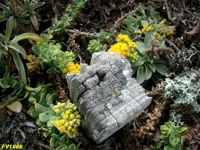
The pix of the stub/post (September log) are with a Sanyo S870 and the pix from the June log are with a Canon PowerShot A620. The LCD viewer on the Canon recently stopped working, the Sanyo is my wife's and I kinda confiscated it. I use IrfanView to resize/resample, sharpen and color adjust the pics to post them here.What camera are you using?So - is that redwood stub from the 1873 monumentation?
Hard to say about the stub without a tack in it. The 1962 recovery mentioned the presence of two stubs and didn't mention replacing them. This would be the stub "to the east". That sure looks like the impression of the endpoint of some type of nail/tack. Here's a pic of a copper tack that I'm pretty sure is from 1883 (Red Rock) - it looks much smaller than that imprint in the top of the stub (the lead plug is about 1-1/2 inches across).
The stub is really weathered, I didn't get a side shot of it. It is definitely buried farther in the ground than I noted in the June log - you can wiggle it around on both axes, I'd say there is 1/8 inch clearance on the sides at least where it breaks the ground. I didn't measure it but it is protruding from the ground about six to eight inches. I guess a redwood post is a stub unless it sticks up from the ground by a certain amount? There was a piece of redwood laying on the ground southwest of the monument - I scraped down about an inch but didn't see any evidence of the southwest stub.
I had fun making that sketch. I made a screen shot from a satellite view then used Paint.Net to isolate the shape of the point and get its outline - then it has this cool tool (pencil or ink sketch, can't remember which) which made it look like a sketch.... base map on yer site sketches?? -
Hard to say.... can't really see where the disks are in the imagery. In one instance the triangle on the topo overlay was 7.6 feet off and in another it was 31 feet off.
-
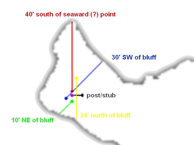
I recently found myself with a free Saturday afternoon and decided to try and find FV1888 - Sierra Nevada which is over on the coast even though I had previously decided to concentrate on an inland level run that is partially in the Los Padres National Forest.
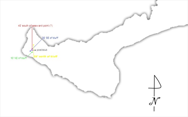
I tried to find this station back in June but was stumped. The station is out on a point and I got confused with the measurements called out in the description - four measurements from the bluff edges on the point.
I had a mental picture of approximately where it should be from Google Earth and Maps. All my measurements were complicated by not being confident where the bluff edge was - the vegetation stopped at about a foot or two from what was probably the real bluff edge (topsoil was eroded on a downward slope to the edge) and through decades of vigorous safety practices at work I've become reluctant to stand on undercut cliff edges without fall protection
 so I just used the edge of the vegetation.
The station description calls are:
40 feet south of the seaward point
There is a 'point' north of the stations approximate location (GPSr) but this 'point' is definitely NOT seaward it points north not west/seaward
30 feet SW of the bluff edge
10 feet NE of the bluff edge
the total NE/SW diagonal distance seemed less than 40'
24 feet north of the bluff edge
This measurement didn't jive at all with the other three
Because of my confusion I relied on my metal detector to find it, the area at the end of the point isn't that big so I figured it would be an easy find. The ground cover was about 6-8 inches thick - no match for my metal detector. Luckily there was what looked like one of the redwood stubs that was supposed to be 6 feet from the station according to the description. I searched and searched, with my metal detector, out to 10 feet from the stub/post. Hmmm... it didn't seem to be there, well maybe that wasn't one of the posts. I decided to search the whole north end of the point and still didn't find it (actually went over it a couple of times).
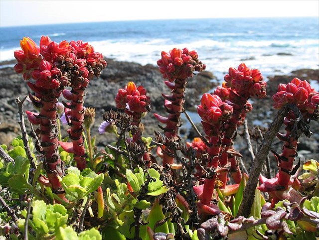
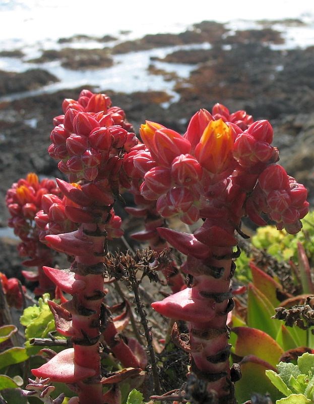
I gave up after a while, took pix of some cool succulent flowers that were right at the bluff edge and headed off for China and China Gulch which were also on my list for that day. I got stumped on these also because I couldn't get past Arroyo de los Chinos - the banks/bluffs were too steep with no paths and it was getting late.
-flower pix-
So with my free Saturday afternoon and a hankerin' for some beach-time I tried again for Sierra Nevada.
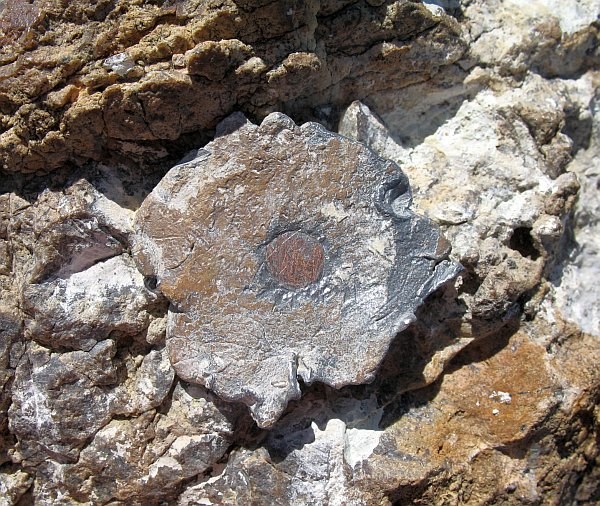
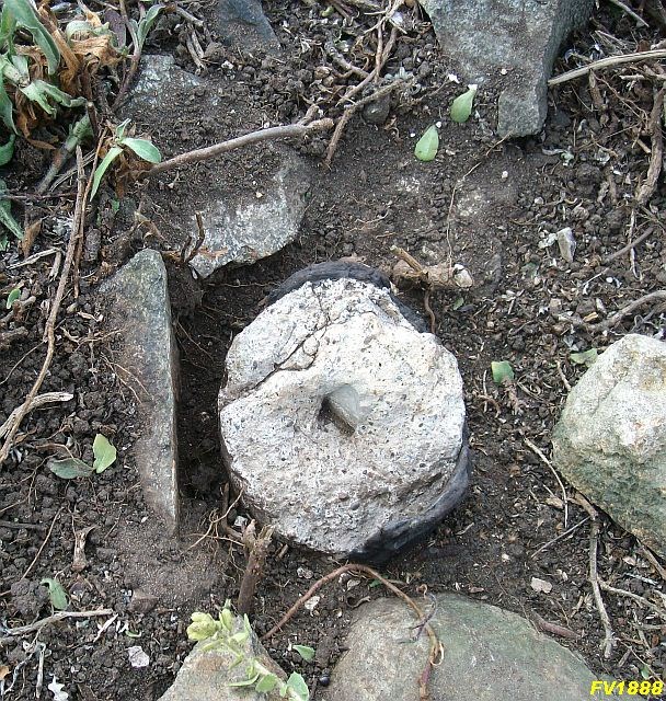
This time I decided to ignore the inconsistancies and just rely on the measurements. I set down my GPSr and made all the measurements placing a pile of rocks at each one. I started with 40 feet south of the seaward point. I picked points on the bluff edge for the other calls so that their terminus would be close to the first measurement. Curiously three of the measurements were pretty close to each other and made a triangle that was approximatley six feet west of that redwood stub/post. (yeay!!) I looked at all those lines and tried to picture where they would intersect if I swung arcs for them but none of those intersections really matched up with each other. Finally I got down on my knees (heavens to murgatroid) and began parting the ground cover within that triangle. I was actually surprised when I found it. It was pretty close to the first measurement and within that triangle - the purple dot in the pix below. The top of the monument was broken off and the disk is missing. The monument is poured concrete in an orangeburg soil pipe (lot of these around here on the coast) - no metal!! The monument is exactly 6' from the redwood stub.
-site sketch-
-Sierra Nevada surface mark monument
-Sierra Nevada redwood stub with imprint of a tack in the top
A little bird mentioned to me that I might want to post this and describe my methods - I was reluctant at first because it seemed haphazard at the time and in retrospect I wondered why I didn't search that 6' radius from the post on my hands and knees the first time!

-
.png) 1
1
-
-
I appreciate the info. I'll definitely look for it. Thank-you
Waymark it and post a picture here - those are cool (he says as he unfolds his national forest map)...
-
I found it on that site, thanks! I guess I can't log it in GC.com since it is not in the NGS database but I did create a waymark for it. And the two marks on the peaks, did I have to go there to log them or take pictures of them, or since I was in between them I could log them? I am sure I saw them but didn't know what I was looking for at the time, nor will I be back anytime soon if ever. Just wondering what the requirements are for this? Don't want to cheat, but if I deserve it, I would gladly log them.
If there is a disk you need to see the disk to log it and we love to see pictures of disks and their surroundings.
As kayakbird mentioned Val and Oval look like they might be intersection stations - which don't have disks. You can read about intersection stations here. To log these you have to make sure you saw the exact feature written in the description.
-
....
It is near the dam near Lake Mills in the Olympic National forest.
Thanks for your help and time in advance!
Checkout this NGS Benchmark Viewer - navigate to the dam (Upper Elwha Dam) and choose the MyTopo map option. Putting "Lake Mills, Washington" in the location search box seems to work. Zoom in to the dam... See the "BM 605" just above a triangle near the dam? That triangle is most likely your survey mark (note the elevation stamped on the disc).
Doesn't look like that mark has made it into the NGS database so it won't be in the GC.com database. If you zoom out a bit from the dam you can see two marks on peaks just west and east of the dam - these are in the GC.com database.
-
Definitely REVEL !!

You can also make a waymark for it over at www.Waymarking.com. It's a Groundspeak site and you can use your geocaching.com username/password to log in.
-
ftp
in Benchmarking
Also, you can get complete counties at holoscene's website here.
-
There are a couple of great GSAK macros for Google Maps and Google Earth (KML). I have changed a couple for benchmarks - They work great.Of course you could use GSAK to create a .gpx of the marks that interest you (from your own database) and open that with Google Earth.
What are they?
At the GSAK Macro Library Index enter "google" in the Macro Download Index Search box. I really like Google_Map_V3. Off the top of my head I can't remember which Google Earth macro I use. I mainly use the Google Earth NGS Overlays mentioned above for Google Earth.
That Library index is in the GSAK forum.
-
Of course you could use GSAK to create a .gpx of the marks that interest you (from your own database) and open that with Google Earth.
There are a couple of great GSAK macros for Google Maps and Google Earth (KML). I have changed a couple for benchmarks - They work great.
-
Now that is weird. You mean the red things were growing right out of the leaf?
Did you dissect one?
The tree was covered with them (leaves only - maybe 1/30). I might go by again this weekend, If I do I'll try to dissect it. I also wasn't really paying attention to what kind of tree it was and now I'm curious about that. I had my nose to the ground loking for that dang mark - I've yet to find a previously NF.

-
-- hiccup --

.png)

Curious?
in Benchmarking
Posted
Is this it?? Q 431