


billwallace
-
Posts
307 -
Joined
-
Last visited
Posts posted by billwallace
-
-
-
- It is FUN!
- Many skills involved
- An excuse to get out and walk around in the boondocks.
- Historical
- Technical
- Lots of details
- Get your OCD on!!
-
-
Four hour drive for me but I've got some time off soon with no plans, maybe ... I used to spend a lot of time just west of there north of Lake Berryessa - nice country.
-
I use GE Tools a lot - the quality of the USGS Topo overlays at Google Earth Library is so good, I went ahead and purchased a few. Check it out, they have a couple of freebies to try out.
-
Just how the numbers work out after the adjustment - it's a quality assesment?The difference between a height value that is Class II vs. Class I has to do with some fairly minor, but none the less important aspect of the leveling field procedures and final analysis. In practice the difference between any two nearby marks should be in the sub-mm range.
-
Absolutely the Jefferson Pier. If you a little sharp eyed you might want to look for A 8 (HV8076) and B 8 (HV8077).
Hmmm all those around the base are Class II - what has the most affect on that, distance to a class I control? Is there one variable that typically affects that the most?
Is a handheld GPSr OK to carry (opposed to the one in my phone and camera)?
-
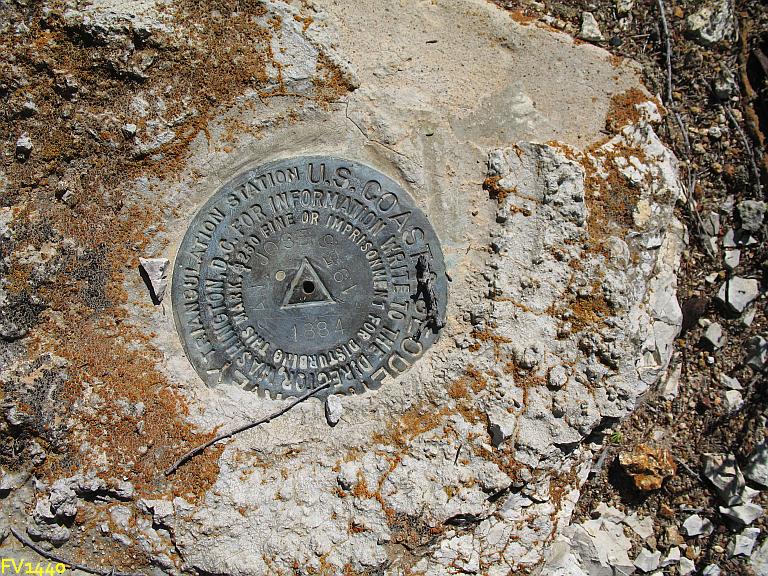
Excellent, some of my favorite - and I see there are a few of them."chiseled crosses",
>marks near some of the monuments
I'd be somewhat cautious about "non-tourist-like" activity around famous memorials and buildings.
But, like mentioned - no tools.

Definitely Jefferson Pier, I'm reading a biography of him now. And, Thanks for the tip - no benchmark hunting paraphernalia, be nice and courteous to the men and women in uniform. I didn't know about the pocket knifes - I carry one out of habit. thnx.
-
This one? Mark in D.C.
Oh yea, I almost forgot that one. These are also on my list - easy pickings:
-
I'll be in D.C. in a couple of weeks and my wife has already laid down the law - NO BENCHMARKING!! But if we happened to walk past a couple of marks while we are seeing the sites, which might be the best to accidentally trip over? (Sometimes you have to be a stealth, ninja, benchmark hunter).
-
Here's a Primary up in the 35th parallel part of the state - the scenery on the 1st page of the article was kinda deja-vu
-
A couple of weeks ago my daughter and I went on a speed run and found about 29/50 along Jolon Road in Monterey county, Ca - YEAY!!
I have been lazily logging them on GC.com (lazy is the operative word here) and included my found coordinates to 2 decimal places (seconds). I thought about it a bit and said 'well its only a GC log, I'll do it right when I log to the NGS'. I finished up my GC logs and started in on the NGS logs. I typically look to see if there is a recent recovery first and much to my surprise the PIDs I logged a week ago all have HH1 coordinates that match my GC logs. I don't think my Colorado has suddenly become that accurate. Anyway ... perhaps there is an automated process now that is pulling the coordinates off GC logs and determining the accuracy by the resolution used when we post them. I went back and edited all those logs and rounded correctly.
FV0218
FV0219
FV0220
FV0221
FV0222
FV0223
FV0224
FV0767
FV0769
FV0770
FV0771
FV0773
FV0774
FV0946
FV0948
FV0950
FV1823
FV1951
GU2406
GU2407
GU2413
GU2416
GU2417
GU2418
GU2887
GU4310
GU4311
GU4312
GU4313
-
Thanks for the info, Do you have a link for DSWorld? Never heard of it.
You may like the Google Earth app also - same author as NGS>>GPX
-
Yeay - thnx. I use it a lot - it seems to load much faster now.
-
... I need the coordinates (in same format for use in GPS) exactly one mile north and one mile south of: N 38° 21.229 W 081° 37.582...
FizzyCalc is a nice tool for your box
-
-
Waymrking.com if you'ld like. How old is it, maybe you could find it in this 1911 publication
Annual report of the Isthmian Canal Commission - Google Books
-
I have been using FizzyCalc, which I found on Holoscene's wiki, - its pretty handy for conversions/projections and getting vectors/azimuths&distances
-
... GSAK can handle the 63,919 benchmarks (and associated child marks) in California. NGS>GPX doesn't fare quite as well, you have to split the state file into two files to process all of the marks. ...
I just ran California thru NGSGPX the other day, it hung twice but ran thru the whole file the third time. I like to use (G)AWK scripts to extract datasheets out of the state file - its pretty fast.
-
..... The only thing worth seeing within ten feet all around was the benchmark itself.
'nuff-said

-
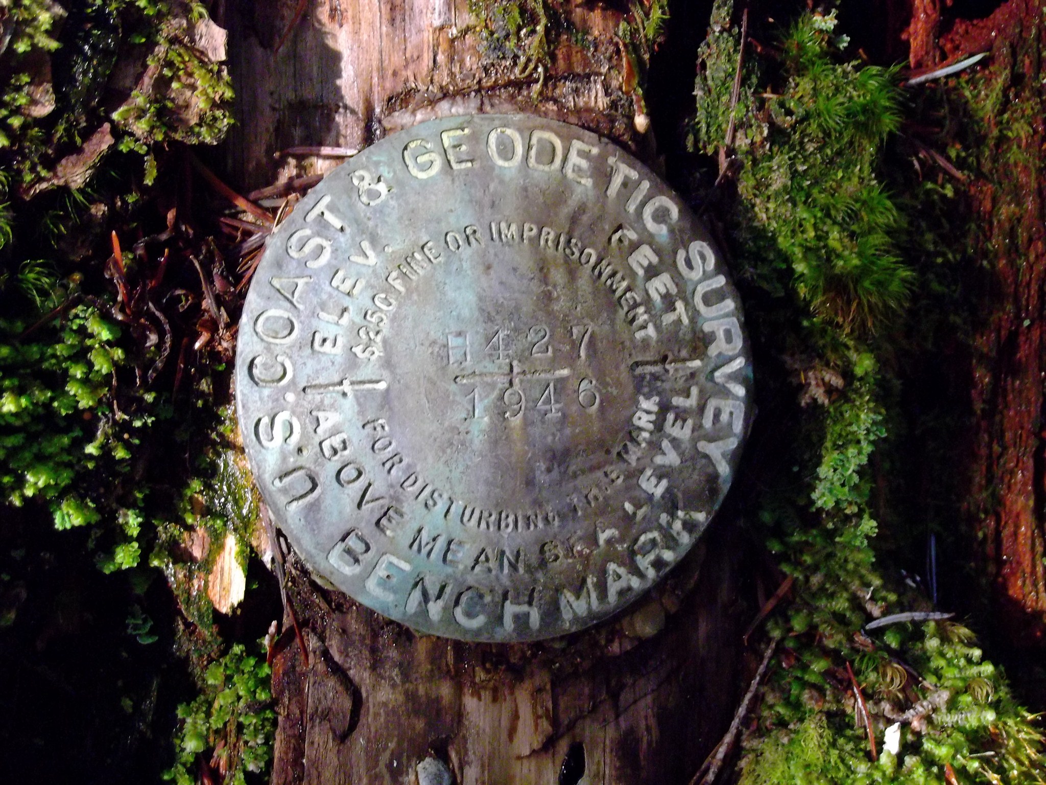
Found this one a few days ago. (F 559 1957)
Did you take a gander at Wallace Creek while you were down this way?
If you'ld like, next time your coming to the central coast, send me PM and maybe we could hunt a few together. I don't get out much lately but I check the forums often.
-
My favorite benchmarking app!
-
The description says that it is on the southwest end of the abutment and that it is 14' from the road centerline. The "BM" in your pic looks like it is on the northeast end of that abutment and more than 14 feet from the road centerline.
-
Or this file for Google Earth: http://ngs.tsqmadness.com/ge/benchmark_150.kmz
website: Google Earth Survey Marker & USGS Map Overlays | TSQMadness.com
-
On a lighter note you can filter a dat file for stations with less than 1 meter difference between orthometric and geoid heights - find those stations and stand on or touch a mathematical construct - the ellipsoid. how cool is that. a project i've been itching to do.
-
Go Arizona!!
Yolo Base Line 1881
in Benchmarking
Posted
Thanks Bill93(ish?) - please keep these posts coming.