


releasethedogs
-
Posts
411 -
Joined
-
Last visited
Posts posted by releasethedogs
-
-
Thanks for the reply sick4x4, i look forward to your visit. Send me a PM when you have your final plans.
-
I have the same unit but never bothered to get the data cable. Back when I got it people told me you can load them on if you have garmin comunicater on your computer and use the "send to gps" function of this website.
-
I have a Dakota 20. As for map set I generated one map of Korea and another of Turkey, Jordan and Egypt. But the GPS sees them but they have the same name under enable/disable maps in the dakota 20 control panel. When I download it from OSM it is a .img file which is already compiled, correct?
Was the filename for each of the maps (Korea, Turkey etc) you downloaded named gmapsupp.img?
Yes.
There is a way to do this, it does mean using the command line.
download the Mac version of gmt from http://www.anpo.republika.pl/download.html and extract it
run it like
gmt -w -m "NEW DISPLAY NAME" imgfilename.img
then copy it the GPS as before.
AHHHHH! If there is one thing I fear it is clowns. If there is something I fear more than clowns it is Death. If I fear anything more than clowns and death is is spiders. If I fear anything more than clowns, death and spiders it is DOS. I fear command lines because I was born with a one button mouse in my hand. is there a tutorial or something?
-
Ok, the gigs up. I'm a Garmin Map n00b. I have no idea what MapSource is. I amuse it's a program? Is it available for MacOSX?
-
Should be able to left click on the file while still in the PC and left click it again to edit the name like you would edit any other file name. Then when its uploaded to the GPSr it should have the new name.
I know how to change the filename. that does not effect how the GPS sees it.
You need to be careful there. What kind of GPS do you have? Only newer GPSs can handle renamed mapsets.
You also need to be clear on what you mean by a mapset. You can have a compiled img that has various imgs combined which you can rename. Or you can have img files installed on your computer into MapSource/BaseCamp (which you then use to combine the img files and send to your GPS. You cannot rename those img files. I cannot tell which you are talking about.
I have a Dakota 20. As for map set I generated one map of Korea and another of Turkey, Jordan and Egypt. But the GPS sees them but they have the same name under enable/disable maps in the dakota 20 control panel. When I download it from OSM it is a .img file which is already compiled, correct?
-
I have a few Garmin maps generated by OSM and they hall have the same name. I'd like to know if I can edit them so they will reflect the regions/countries that they represent. Possible?
-
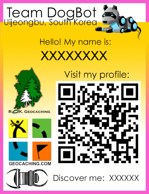
Ok removed the logos and made it more simple. Printed out and ready to go to an event at the end of this week.
Geocoin Club sells a trackable name tag, also
These are more fun to make.

If this thread becomes an advertisement for these for sale, it will be closed. There is no advertising allowed in the TB forums.
Understood. I understand your just trying to be proactive but I never said anything about offering them for sale. I want people to make up their own, that is kind of the point of this thread... To see what other people can come up with.
-
how do you go about solving puzzles any how. I mean sometimes they show just a random photo. I really don't get them most of the time.
-
in addition to the above, I am 90% sure vehicular gps devices "snap" your location to the nearest road.
-
I think, the badge looks good and busy enough, adding more would be OTT
yeah i think you have a great point
i think i may nix the geocaching logo and the ROK logo.
-
.png) 1
1
-
-
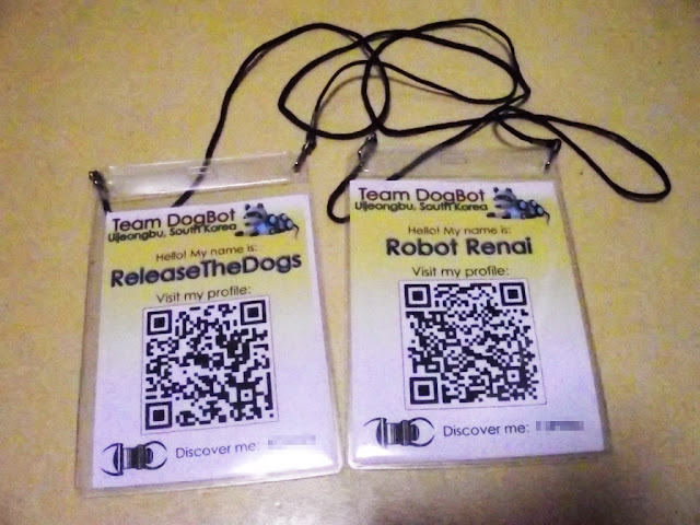
I just made some trackable name badges for my wife and I to wear at events. I include my handle on this website, our team name, and our trackable code so we can be discovered. Also, I included a QR code so tech savvy catchers can visit my profile if they choose. What do you think? What could I add? Do you have a designed name badge? Post it here for everyone to see if you do. Also the pink outline is the over run area. it gets cut off after printing.
-
If you are in the United States and old enough to post on these boards (13 or older by law) then you are old enough to figure out a way to get money for a GPS. I did odd jobs for my neighbors when I was a kid and bought a NES, Gameboy and later Sega Genesis. Go mow some lawns and save your money.
-
just make it a 5/5. lol.
-
The geocacher named starless has cached in 44 countries.
-
personally Id rather someone have the option to leave no comment then "TFTC" over and over and over. A Pocket Query only downloads 5 or 6 of the most recent logs and it sucks when you get hone and the 7 or 8 comment down could have helped you find the cache but you never saw it because every one was forced to type something so they wrote "TFTC".
-
I am confused as to why the ape caches are archived. I realized the containers went missing but why didn't some one just replace them? Should they be brought back? Discuss.
-
I think you and the rest of Japan havs more important things to do and worry about then some one who wants to armchair log geocaches. If they want to play the game that way, let him (or her). They are only cheating them self.
-
I think putting "harmless geocache" really does not matter. If it looks like a bomb, or even like it could possibly be a bomb then the bomb squad will blow it up. Also, whats to stop some who who makes a bomb from spray painting "harmless geocache" on a bomb?
-
I just read herethat the Earthquake in Japan shifted the entire country 13 feet to the east. Does this now mean that every cache in that country is now off by at least 13 feet?
Discuss.
-
I am in Seoul/Gyeonggi-do. If it is on the weekend I may be willing to travel to other parts though.
-
At the very least make sure the stages have a point beyond making someone do extra work.
This is the most important part. The best multi's are ones which take cachers on a short tour of an area, often a city centre, pointing out places of interest along the way. The advantage with multi's is that you don't have to have a physical hiding place for each cache so you can take the finder to literally anywhere you like that might be of interest.
Or you can do the above as a puzzle like i did ---> http://coord.info/GC2GN2Z
-
This has been done before, I dunno if it would still be allowed. You should ask your reviewer about it.
-
I am making a cache "achievement" system similar to BadgeGen and I am having a hard time finding large cache icons to go with my achievement graphics. Does anyone know where or how this can be had?
-
A couple of years ago I found a cache and there was a note in the logbook at that the cache had been found by someone that had been doing some nude hiking. He claimed he had inserted a body part into some playdoh that he'd found in the cache (and had returned the playdoh to the cache). As I recall he even left the address for a nude hiking website in the log book.
this guy?
.png)
Changing names of Garmin maps?
in GPS technology and devices
Posted
W000000000000000000000! I will try this for sure, as soon as if get my wife to lend me her windows computer for "hacking". Thanks so much.