


xxgg
-
Posts
142 -
Joined
-
Last visited
Posts posted by xxgg
-
-
you can upload using Mapsource as waypoint.
And it'll be all listen under Favorites on your GPS unit.
-
Sanyo Eneloop.
Google for review, you'll be impressed.
-
[quote name='space_man' date='Dec 21 2007, 03:16 PM' post='3214517I also called Garmin to let them know that the GPS was stolen and they said if anyone would try and use it on the net it would be shut down and made usless.
Alex
If that is the case, Garmin should be able to log the IP address of the computer that was used to connect to the net. That should help to track it down.
Not sure if that theif's Internet Service Provider will allow to our their customers informations but... Garmin could surely contact the ISP of the theif and find out exactly who was using that IP at the time.
-
I have Garmin GPSMAP 60CSx.
Instead of just looking at the traces of track, I would like to do see it in more detailed view.
For example...
Is there a program where I can view the track on a map and at same time have some sort of linear graph which I can slide around or interact with to see the detailed informations? Like elevation, speed, and any other informations that is logged to the track log file.
I am sure there are some programs which you can view all these logged details creatively/ interactively, right? All in both visually & text would be very nice. If not, something close to it would be nice.
Ok. The first program you should try is SportTracks. This is a great program for managing hikes, bikes, kayaks, runs, etc. Takes your track in .gpx format and puts it on a map, does some calculations of distance, time, average time, fastest and average pace, etc. Creates graphs such as elevation. Click on the elevation graph and is shows the spot on the track/map. Fun to play with. You can save the image of your track on various maps and satellite and export to google earth.
If you need to convert your track to .gpx format, use GPSBabel.
Thanks, program looks interesting.
-
I have Garmin GPSMAP 60CSx.
Instead of just looking at the traces of track, I would like to do see it in more detailed view.
For example...
Is there a program where I can view the track on a map and at same time have some sort of linear graph which I can slide around or interact with to see the detailed informations? Like elevation, speed, and any other informations that is logged to the track log file.
I am sure there are some programs which you can view all these logged details creatively/ interactively, right? All in both visually & text would be very nice. If not, something close to it would be nice.
-
Any car adapter with mini-USB (5 volt) would work.
It'll charge your rechargeable GPS devices.
For 60CSx it would just power it.
Either they works, I didn't have any miniUSB car adapter, didn't feel like making my owns, so I ended up buying a actual power adapter.
I think I should have just bought a miniUSB car adapter as it is little chaper.
-
Hello.
Could you recommend me a good software for re(viewing) my track logs in variety of ways?
Like linear, graphically, timeline, etc...
What software(s) do you people use for analysing? detailed viewing your track log(s) with?
I would really appreciate it.
Thank you!
-
I would say Garmin user interface is the easiest to use.
Garmin nuvi 200 should be in your budget.
-
Now...
Some of you are using a actual seperate compass.
Which brand/model compass do you use (primary) ?
Web link (pic) would be nice.
-
No, you do not need to buy any type of antenna.
Built in antenna is more than good enough.
-
Just wondering...
What type of CPU is used on Garmin 60CSx ? Also, how much RAM? (not ROM)
-
Hello.
Unit: 60CSx
I am wondering if there is a way to make my own custom icon under "FIND" section?
Is it possible to add my own icon to seperate custom PIOs ?
or does all custom PIOs have to be under 'Custom Points of Interest' ?
Would be really cool if I could make my own icon for my own categories of POI.
-
-
-
Ultimate GPSr ?
Paperless? How about a paper flexible alike display?
http://www.popularmechanics.com/technology...607.html?page=7
Using such a technology, incorporating entire Google Map features like their new terrain feature for topo map viewing.
Plus all other regular stuff like touch screen, total waterproof, longer lasting battery life, voice guide even for handheld navigating, voice recognition? (have you guys tried it for computer? first you need to have a one of those clear voice tone, oh yea... you got cold? ain't gonna work for you anymore). Pay As Go Satellite phone feature for extreme emergency only as it cost bloody too much, i personally want some futuristic graphical user interface like you see in movies making the device that much more cooler. Heck, let's put a finger print security feature to unlock the unit before use, just in case you lose the device. Oh... no monthly fee GPS tracking too. Even more deadly accurate GPS chip for absolute dead on pin point location accuracy.
AND much much more which I can not think of due to my lack of imaginary mind.
We may just see some of these features in few years? maybe 10+ years. Heck, I thought we were gonna see some flying cars by year 2000 too. Oh well.
"DREAM ON!"
-
-
Where did you guys purchase it from?
-
oh i am sure you can think of a way to make one yourself.
-
I think this is one awesome feature for TomTom product.
I agree it looks great, but how do I use it for caching? I can't find any "content to add" about Geocaching.
Vic
Well...
First of all, you need to know the GPS Coordinate of your cache.
Goto maps.google.com or .ca or whatever google map site you choose.
Enter in your GPS Co-Ordinates and Google will automatically pin point the location on the map.
That is it.
This is excellent for using with any GPS unit for pin pointing the exact location... providing that you do have a correct GPS CoOrdinate(s).
Now, if you are getting your Geocaching from www.GeoCaching.com everything is automated for you. They provide all the link you need to Google map and other online map websites.
Enjoy
-
I think this is one awesome feature for TomTom product.
-
I am not sure but doesn't upgrade mean you should have your previous version isntalled? than you install this upgrade on it?
Since it is only a map update, I don't see why it would need a unlock code?
It should still be working with your previous unlock code.
Think of it as having a Windows XP installed with cdkey. And this upgrade is like Service Pack for XP.... which requires Windows XP for it to be installed.
Doesn't that sound right?
-
iGuidance
-
Hello.
I am just wondering what type of mount/clip you are using with your GPS unit.
What brand/model GPS unit do you have ?
What mount/clip do you use in your car?
What mount/clip do you use when walking/trekking?
or any other type of mount you have? bike?
*would appreciate it if you could include a weblink with picture of your mount/clip for us to visualize it*
------------------------------------------------
As for trekking, I just use belt clip that came with my Garmin GPSMAP 60CSx.
For in car use I have RAM Mount with aluminium arm (little bulkier than I imagined but very well built)
I personally like to mount it lower left corver of my windshield.
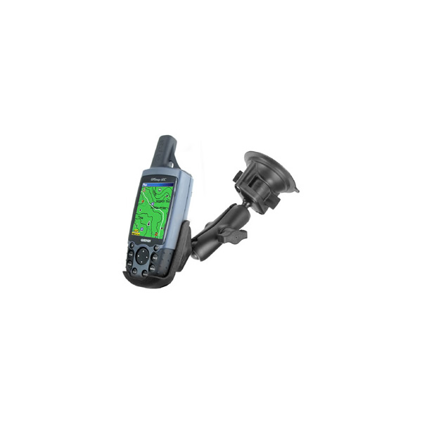
How about you?
-
Well on a Compass screen. I guess if I move/tilt my unit i would get HOLD on bottom left corner of the screen and LEVEL on bottom right.
Not sure what it does.
60CSx Battery type option.
in GPS technology and devices
Posted
Hello.
I have Garmin 60CSx and I have a question about battery type.
First of all, why does it even have this option? Alkaline & NiMH option.
Does it change something when certain type of battery is used?
What if I use one kind yet in option I set it to other type?
What/Why does this matter?
I would really appreciate your knowlodge regarding this option about batteries. +Your experience with it.
Thank you!