

rlaughton
-
Posts
6 -
Joined
-
Last visited
Everything posted by rlaughton
-
Dear Members: I arrived at this web site some time ago as part of my research to find, photograph and mark (by GPS) the grave sites of Canadian soldiers of the Great War. This is just part of a overall goals of the many members of our teams to find the historical references of our grandfathers, great-grandfathers and now maybe even great-great-grandfathers who served in the First World War. In cooperation with the Maple Leaf Legacy Project (MLP) and the Commomwealth War Graves Commission (CWGC), I have been working to log the grave sites of the Great War Soldiers from my home town in Milton, Ontario. I have now compiled the history of each of these soldiers, which you can find on the web site of the Milton Historical Society Great War Soldiers, and I am this year adding the information as it relates to all of their grave sites. Much of this is now being uploaded to that specific site on the Google Earth Community - Milton Soldiers Moderated Site. I raise this topic here as it is what I believe to be a "Historically Significant Geocaching Experience" that can be of interest to many members and also of great benefit to those like myself that are searching for and marking these grave sites across Canada and perhaps around the world. My project aim is to have the international memorial organizations recognize the importance of GPS marking so that the GPS coordinates are added to all of the grave site memorials. If you take a trip to the start of the Milton Soldiers on Google Earth then you will see my objective. If you want to take it on a simpler term, then take the trip I took this past weekend to find Private John Hastings Blair in the Guelph Woodlawn Cemetery. On the CWGC you would find him at Block E, Section 12, Grave 35 and on GPS you would find him at 43.56103N 80.277802W. If any other members are interested, I would like to coordinate a group that could get the GPS readings of all of the grave markers of the Canadian Great War Soldiers that are on the MLP project web site in Ypres, Belgium. That means all the relatives, researchers and students can go to the grave markers with their GPS in hand, saving hours and hours of time. What took me two hours to find in Guelph would have taken 10 minutes by GPS. I have a large group interested in doing this work in France and Belgium but we would need a much larger force to do this in Canada - a much larger area! On the side, I am also marking many of the grave sites by Google Earth "Visual Identification" so that I have on-site GPS versus GE GPS. I hope to assemble all of those results from hundreds of markers to provide a reference tool that will enable us to do site correction calculations. I have some university researchers interested in that project - let them do the math! Hope some of you have an interest, Richard http://www.richardlaughton.com
-
I was going to edit my post above to note that I have updated that EXCEL spreadsheet so you can now use it to convert between DD.MM.SS; DD.MMMM and DD.DDDDDD it both directions. Handy to have when you are out in the field checking benchmarks. I checked on EDIT in the HELP section and it appears there is a time limit allowance for editing the posts. The link is in the post above. Enter your data where the numbers are PINK.
-
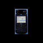
I did a Forum search and a Google search of this site and could only find one mention of the Moto Q9. My apologies if I missed something, and if so, the moderators are free to delete this topic. As part of a longer term plan to use the Linesman Program in Europe for tracking WWI trenches, I started a hunt for what would be the best "all around" system that would have the GPS capabilities, communications and software for the field. My end result after months of review was the Motorola Q9h Smartphone, a HOLUX GPSlim 240 Bluetooth GPS and CoPilot7 software. There was a trick to getting the CoPilot and the MotoQ9/Holux system working together, so I wanted to make sure that if anyone else is taking this approach that they know there is a simple solution and once complete the system does a great job. The ability to have your e-mail, phone, GPS and computer all in one package is a real benefit for the field work. That means you can also run your Google Earth at the same time! CAUTION - this is for a MotoQ9h with a stand alone GPS system, not the one that you would get as part of a service package from your cellular supplier. Stay away from those is what I have heard. You also have to pay a monthly fee for that GPS service but a stand alone system costs only what you pay for the hardware and software. I chose the HOLUX GPSlim 240 as it was small and had excellent reports as to accuracy. I needed a Bluetooth device that I could place in spots and take the readings elsewhere, whether in my car on COLD days like yesterday, or otherwise out of the elements and danger areas. I went with the CoPilot7 software as it has the ability to take direct GPS readings, it is not just a travel GPS system. I also wanted a system where I could add maps of Europe for the Great War grave hunt. So far all is working great. I am now in the process of doing a number of tests here in Ontario to compare the readings from Google Earth (I use those to track the cemeteries) to the benchmark points (three cheers for COSINE) and the handheld GPS. There are a number of others on the MOTOQ9 forum starting to use this system as well so I will drop them a note to come here to Groundspeak. I look forward to helping anyone else using the MotoQ9 system and also to sharing experiences and updates. Richard of Canada (click here for a large scale view of the system in my AVATAR)
-
Thanks for the information. I will go through all the information and see what I can find here close to Milton. I did note the "rail spike" at the Ontario Science Centre, that looks interesting. Thanks for the PM with the information on the COSINE database for Ontario. I spent considerable time there yesterday and found great information. I was able to get more than a dozen reference sites, with sketches, coordinates and other information all within a 2 km radius of my house. I don't know if these are as accurate as the "Canadian Benchmarks" but I assume for my initial purpose they are a good start. I was impressed at the ease of the COSINE data retrieval process, the detail they provide and the fact that it is now ALL FREE. With that large number of data points it is going to make it much easier to triangulate on the specific WWI Milton Soldiers gravestones I am trying to mark, there are many data points surrounding the cemetery. We hope to learn here and then apply this in France and Belgium on thousands of sites. Next time I decide to go and look for them, as I did in the -12 degC weather yesterday afternoon, I will take a pencil - as the ink in my pen froze! I also changed my conversion spreadsheet so it will change from the different formats. It is handy to have loaded on your phone when you are out at the site: EXCEL Data Point Conversion
-
I would like to find some Canadian Benchmarks so I can find out how close my GPS unit is to the "real thing" I looked on the PARENT SITE and found only one listed for Canada here: N 48° 00.100 W 089° 35.100 I assume that is because the parent is American? There must be a number of Canadian benchmarks in most municipalities. We can't search by our POSTAL CODES only by US ZIP CODES. I searched for CANADA and found only that one CANADA US benchmark. I am located at 43.5005139N 79.873961W which is west of the Greater Toronto Area. As a minimum I would expect there would be benchmarks down around Niagara Falls. I would have thought they would have been at the major airports and many other locations. Is it just that this is not a Canadian site that they are not listed? I am trying to create a "corrections table or formula" for my handheld GPS relative to what is on Google Earth. My hobby is research on World War One and so I am plotting Canadian War Memorials and the grave sites of Great War soldiers (Canada and elsewhere). It is relatively simple to get the cemetery placed but much more difficult for a memorial or a grave. My latest test was a remote memorial in Brookville (the Haltonville Memorial) which is in the Town of Milton, Regional Municipality of Halton. The test showed some degree of accuracy with a GPS handheld as compared to the Google Earth coordinates (only a few feet difference) GOOGLE EARTH: 43°31'28.77"N 80° 2'10.92"W HANDHELD GPS: 43°31'28.68"N 80° 2'11.08"W I would like now to be able to compare a known benchmark to the readings on Google Earth and the readings on my GPS. See also these articles if you are interested in this topic: http://ohioline.osu.edu/aex-fact/0560.html http://geospatial.osu.edu/resources/handheldgps.html Regards to all from Milton, Ontario. Richard (Moto Q9H with CoPilot7 and a HOLUX GPSlim 240 Bluetooth)
-
Excellent! Thanks for the lesson and the program link. Does anyone know if there is a similar program that is compatible with Windows Mobile - tried that one on my Motorola Q and it is not. In the interim, I have made an EXCEL spreadsheet that does the calculation quickly and accurately, can be loaded to your Windows Smartphone and anyone can download if from my site here: EXCEL GPS Calculator Richard