


GOT GPS?
-
Posts
2949 -
Joined
-
Last visited
Posts posted by GOT GPS?
-
-
Here is a moving cache near Detroit Mich:
"Oakland Transit (Hidden)" by T'Dog (GC4084)
This cache is picked up by a cacher who finds it, then rehides it somewhere else in the same county(Oakland). Each time it is found and rehidden, it is updated as a new cache each time. I went yesterday, but could'nt find the darn thing. When it becomes new again, you can try finding it again, and log it again as another find.

-
Here is one that isn't very good:

It has holes around the handle.
Here is my idea of a container:

It is a container inside another container. Nobody has complained about a damp container yet with this method.
-
That is a different thread.
this is a poll.
-
What is your preferred container that you like to use?? Especially one that keeps out hard driving rain, and is easier for the cacher to close completely.
[This message was edited by Geoffrey on March 19, 2002 at 04:33 AM.]
-
I have the GPS 315, GPS V, and the Vista.
I gave my sister a GPS III, and a friend the GPS IIIplus.
-
quote:
Originally posted by Alan2:If a cache truly ges traded up, who gets to keep the stuff at the end of the cache's "life"? Why?
And when does a cache's life "end"?
Alan
interesting link:
No one gets the cache in this situation.
[This message was edited by Geoffrey on March 17, 2002 at 06:20 AM.]
-
I think that these caches, that can be found first without the GPS, are caches that should not be directly on Geocaching.com, but be sidelinked. Meaning that they are on another part of geocaching.com, and that would be called Interesting use of GPS.com(interestinguseofgps.com). These caches would show up as a blue colored number separate from the physical cache logs.
Example:
Caches placed/Found/Other:
7/55/6
-
I Stock shelves for hungry humans, and one day I was talking to a customer about home networking and routers, I then told him about geocaching. He brought out a few friends to try geocaching, and he is going to get a GPS.
Anybody have any experiences like this.
-
I think that the LCD screen contrast is the issue with the meridian.
I had bought a Garmin GPS Map76 at a boat place, and tried it on a walk and also in the car. I played around with the contrast and backlight, it was so bad, that I couldnt read it when walking, and almost crashed my car because i coulnt see the display clearly. The Map76 has a yellowish green baground on the display, even without the backlight. I took back the Map76 the next day. The contrast of the store display model was better than the one i had for a day, but still didn't like it.
What I believe is the issue, is that a few GPS units might have a bad display. My little eTrex Vista's display is quite readable.
As far as this message thread goes, I believe that the best way to go is to save up and get the GPS V. Everything about it is excelent, including the readability of the display.
The GPS 315 is a great Geocacher model, but id worry about a broken eMap, with all the money spent on it including accesories.
-
Might need some portable trees to compare readings over a Survey Benchmark, with and without the trees. Also to try different lengths of Averaging.
Anybody tried something like this.
-
America Online lets you create a homepage, and also store about 4 megabytes of files on your FTP site, which is associated with the webpage you create. Whats more, is that if you had 3 screen names under one account, that would be 12 megabytes. Several ISPs allow all this, but I dont know how much they may let you store online.
-
Here is a challenging Cache of mine:
http://www.geocaching.com/seek/cache_details.asp?ID=5759&Nocache=0.7055475
It is on a Disc Golf Course and it is challenging, but it is also considered Geocaching.
-
Geo - Earth - Hidden somewhere on this planet.
Caching - Caching - Finding the hidden Container.
Whatever you call it, is still fun.
No matter matter how you slice it, it's still the same.
-
If you had 3 micro caches with a distance to the MAIN cache in x.xxx miles, it is easy to draw circles of x.xxx miles in Radius on Street Atlas USA, then find the intersection of the circles.
-
meow juice??
-
meow juice??
-
What do you find as the most important feature on a GPS?
[This message was edited by Geoffrey on March 11, 2002 at 07:29 AM.]
-
-
One way to do it, is if some people had some money to rent a Survey Grade GPS, to compare with a few consumer model GPS units, in the open and in the woods.
Is this an idea?
This is one way to see if there are any consumer GPS units that can do Averaging well, or not.
One way to test the Averaging function on many GPS units is like in this Example:
http://www.geocaching.com/seek/cache_details.asp?ID=10951
This Survey Marker is a good way to test many different GPS units. There are several log on this cache page.
-
The Magellan Meridian™ GPS for $219.
http://www.gps4fun.com/mag_meridian.html
So many people keep asking for the very best beginner unit that doesn't break apart or break your budget, and that is expandable later when you do have the money. It has WAAS and a great antenna. The Magellan Meridian is very basic with a data cable included, so you can upload or download data to the Meridian.
The Infinite memory GPS:
You can have 2 or more SD memory cards loaded with map data for long road trips with geocaching in mind, and switch between different cards when you are on a long trip. Memory cards require you to have Magellan Mapsend software though.
Here i am a GARMINITE saying this, but I wish that Garmin had a rugged version of the eMap.
So if you were to have only one GPS, is this the one????
-
I agree with phantom4099 that the best beginner GPS is the Magellan Meridian Green(lowest priced one), and that GPS is greatly expandable, as you get more into using GPS units for other things. You can buy SD memory cards at many stores, and if you bought 2 or 3 SD memory cards, you can have different map sets on each one, for a long road trip.
Magellan Meridian
2MB database with interstate highways, state highways, major roads, parks, waterways, airports, cities and more.
Includes: PC Data Cable; User guide.
It is $219 at http://www.gps4fun.com/mag_meridian.html
-
I found the problem with my not getting several links to work including www.loe.org . The problem is that Ameritech DSL keeps dropping connections to websites, including being logged into this messageboard. Even tried this on a Ameritech DSL service at another house, and even that internet connection could not acces Jeremy's links at the top of this message Thread.
What did work, is logging onto America Online, and im getting the links to work now.
THANKS be to Jeremy for a great outdoor hobby.
-
G7ToWin is a good Waypoint, Route, Tracklog, Screen Capture program for the Garmin.
-
I had an old Magellan 4000xl, but i have a pic of the 3000xl here:
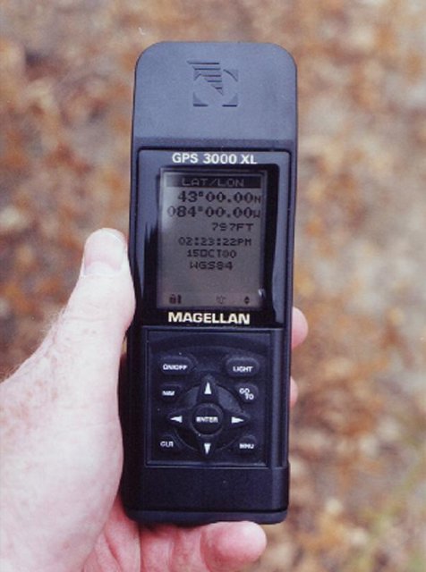
I bought this GPS early in 1998
Would be interesting to see pictures of really old GPS units you have, or a really beatup one you have??
Adult Geocaching?
in General geocaching topics
Posted
This is an old Topic Thread, but i will reply.
You may aready know the 2 questions asked at the airport, when you are checking in your luggage:
1) Did anybody pack your bags for you??
2) Did your bags ever leave your sight, at anytime?
What i am saying to this is that all ADULT Materials, are treated in this same way. If you buy a Playboy, a Beer, Smokes, Liquour, Firequackers, adult flicks, or other adult stuff, it should never leave your sight(immediate possesion), until it is consumed, distroyed, or whatever. So do not allow any adult stuff to enter the hands of a person under 18, or GEOCACHING is history.
It is easier for Catholics, Latter Day Saints, and many other people, in that if you have to be 18 or older to buy something, then dont buy it, even if you were 90 years old. They are the way they are, because materialism and sin will break their connection with the spirt. Keep this sport fun for all.
So, what im saying is that many items are offensive to many people. Even if there was www.adultgeocaching.com , it would still be illegal, to let the items leave your sight.
[This message was edited by Geoffrey on March 21, 2002 at 01:32 PM.]