


platoaddict
-
Posts
16 -
Joined
-
Last visited
Everything posted by platoaddict
-
Add another vote for being able to directly go to the browse map. It seems to me that the proposed changes are contrary to what has been said all along. Most of us do not use the search feature and are used to the browse map. View map always took you to browse, so why change that?
-
As long as the trip is not in draft, it will auto-generate a route in a few minutes. You can manually force this by choosing Edit —> Order new route calculation.
-
Can I edit a log to mark a cache as favorite?
platoaddict replied to Team Dredd's topic in How do I...?
I know some cachers will post a Write Note to a cache that was previously found to alert the CO that they are now adding a favorite point. -
I know of a handful of local COs with a significant number of hides that have mail filters set up to highlight NM logs but not WNs — their biggest complaint with the new logging feature is the useless auto-populated NM log. PGC notifiers, if enabled, will alert the CO to an edited log. The only reason I delete the WN and edit the NM/NA is to keep the logs a bit tidier. Separately, as for keeping the new logging page - I get asked a lot of questions from local catchers. it’s easier for me if I stay opted in to the “newest” features as that is likely their default. I’m aware of the differences and the ramifications of the various logging options.
-
I run GSAK through wine and also use the occasional base camp session. I have successfully connected a 62, 64, 66, various oregons, and regularly use a Montana. Depending on my outing, I’ll either load the GPS from GSAK or (more likely) have a few GPX files that I load directly to the SD card in the GPS. I have a few databases that I maintain with regular PQs. Otherwise, I set up databases for planned caching trips. I am certainly not a GSAK power user, but I’m relatively competent and also use it to log finds. It’s fairly stable using the wine bottler ... some memory leaks (but those have gotten significantly better in recent releases), and Clyde is pretty good about helping out Mac users even though he won’t port it to Mac. Have any specific questions?
-
Thanks. I know about opt out, but I prefer to leave it on the new logging screen.
-
Garmin GPSMAP 66 series announced on 2018-08-06
platoaddict replied to Mineral2's topic in GPS technology and devices
I regularly toggle between a cache description and the map. On other devices, I'm able to do so without losing my place in the description. Every time I did this on the 66, I was scrolled back to the top of the description and had to scroll back down to find where I had left off. Perhaps this was an instance of user error again ... but it repeatedly happened regardless of how I attacked it. Aaah! Thanks! I'll have to look for that again. I searched through a couple of menus while in the field and couldn't find it. I should have noted that this was a very brief and unexpected trial with the 66. I inadvertently left on a trip with my Montana conveniently left plugged in at home (d'oh) ... so, opted for a test-run with the 66 but didn't have enough time to completely familiarize myself with it. -
Garmin GPSMAP 66 series announced on 2018-08-06
platoaddict replied to Mineral2's topic in GPS technology and devices
I'm late to the party here and only skimmed through the 5.5 pages of prior comments, but I thought I'd add some observations of my own. Some quick background: -First GPS was a Garmin GPSMAP 62s -Attempted a Garmin Oregon 650t, and I immediately returned it. Too buggy. -Bought a refurbished Oregon 450t, and I thought it was a good, small device, but I missed my buttons. -Tested the GPSMAP 64s and loved it, but I couldn't justify the cost as it was basically the same as the 62s. -Saw a Montana 600-series and was intrigued; bought a 610t and fell in love. I miss the buttons, but the large screen makes it less of an issue. Great, great, great device -Tested the GPSMAP 66s on a recent caching trip. Was excited to test out the "new" Geocaching Live feature. Needless to say, it's going back. The 66 isn't a bad GPS, and it is definitely an upgrade for the GPSMAP series and for those who like buttons rather than touchscreens. Despite having Geocaching Live implemented, it seems that the device really doesn't handle geocaches as well as on the 62/64 or the Montana. I also am not a fan of the Geocaching Live. It was very clunky to get it set up (via Bluetooth). It was clunky accessing caches in the field. And the fact that it automatically sends a default log upon finding/DNFing a cache is a non-starter for me. The only way I could figure out how to disable that "feature" was to turn off bluetooth. -
If you use GSAK, you can still log a NM/NA through the publish logs feature. On the website, I typically post note, and report a problem. Then, I go back and delete my note and edit the NM/NA log. A bit onerous.
-
This! I agree with a number of the issues already identified in this thread and earlier ones. I understand the desire to move to more "modern" and adaptable tools. But, we shouldn't LOSE functionality. The new map does exactly that. The solution quoted above seems to be an example of a perfect compromise: retaining characteristics and FEATURES from the old map (the popups) while updating and ADDING new features (the list).
-
It may have required that in the past, but it no longer does so. I use it on a daily basis. The only pieces of GSAK that do not work are those that require a program outside GSAK to send data back. Since I primarily use GSAK as a database manager, that doesn't affect me much at all.
-
As for exporting event times in the calendar, the current export is NOT an all day event. It defaults to 00:00 GMT-7 (screenshot below - I'm GMT-4) [If updates are being made, how about putting the coordinates in the location field and moving the GC link to the description?] It would seem to me that exporting to calendar shouldn't be a problem. The location of the event is already known, as is its time zone. Plenty of sites have no problem exporting calendars and respecting the time zone of the location.

-
GSAK runs on Mac - it just takes some tweaking and patience. Thank goodness for the wayback machine. This is the best explanation for how to get it to work: https://web.archive.org/web/20180831165238/http://www.frso.se/index.php/geocaching/how-to-get-gsak8-running-on-os-x You no longer need a windows machine or a USB stick. When it comes time to authenticate against geocaching.com, Clyde created a way for Mac users to do that: 1. Under "Geocaching.com access" select "Get another access token (method 2)" 2. After agreeing to authenticate (geocaching.com authentication page), save the GSAK authentication page (webpage complete) - this is the one that says "send access token to GSAK" 3. Back in GSAK, select "Get another access token (method 2)" WHILE HOLDING control - this will open a dialog box to select a file 4. Choose the saved webpage
-
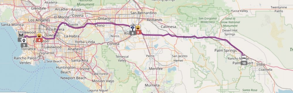
Here's a slightly more detailed explanation of how I use cachetur.no and PGC. 1. I create the trip in cachetur.no and generate a route (Caches in trip will show as will waypoints - in this example it is the airport and our hotel) 2. Then, I use PGC's "map counties" tool to see what counties I will cross on my trip. PGC will show county lines and shade those I have not found. Using a cachetur.no script, I can overlay my route into PGC 3. Finally, I click on one of the counties to see the caches placed there. I have a filter set up for this purpose that will show me only those caches with at least 25 favorite points. I have another filter that will show me only those caches that have been found within the last 7 days. 4. I'll add the cache to my trip in cachetur with a note as to why it is there (the county, the favorite points, etc).


-
I would use a combination of project-gc (PGC) and cachetur.no. Both are API partners. You can use PGC to help find highly favorited caches or implement other filters to carefully identify your desired cache. You can use cachetur.no to help you figure out a route and plan your trip. Both are free to use (though PGC has some features available to paying members only).
-
Establish default open app or website
platoaddict replied to rragan's topic in Official Geocaching® apps
The long press option for a link from an email is a workaround, but I have two additional comments: 1. It only addresses links; not accessing "open in browser" from other apps (e.g., cachly), which will then require going through the steps rragan mentioned above. 2. There should be a setting in the app that allows the user to toggle whether the coord.info link opens in the browser or in the app.
.png)


.png)