+dpbabcock Posted February 6, 2007 Share Posted February 6, 2007 Since my two daughters (my best geocaching buddies) always seem to want possession of the family GPS (Garmin E-Trex Legend) I began to look for options on purchasing another GPS so dad could have some fun too! Shortly after starting my hardware search I came across these little Bluetooth GPSR "hockey pucks" (they are about the size of a small box of matches) and I became intrigued by the idea of leveraging my cell phone for the display device. You can get the little GPS units for as little as $70 and I already had the cell phone. A lot of cell phones and PDA's have Bluetooth connectivity these days. Unfortunately, it turns out that MOST of the cell phone application software out there for GPS use is oriented towards street navigation. I wanted something that would be more useful for geocaching. Being a Java programmer, I decided to write one. After all it isn't really that hard to parse the NMEA strings that come out of the units. The only thing I had to do was parse it and figure out how I wanted to display it. I've been field testing the result for a week or two and would like to open it up to anyone else interested in testing. This may have commercial possibilities down the road. You can see some pics of my setup at http://www.btgeocacher.com if you are interested. If you have one of these Bluetooth GPSR's and would like to try it out with this application and your Bluetooth enabled cell phone, I'll be glad to work with you. Just drop me a line. FWIW, I've done extensive side by side comparisons for accuracy with my Garmin E-trex legend and I've been amazed at the quality of these little GPSR's. Also, they seem to have newer GPS chipsets (like the SIRF and others) which I can attest are DEFINITELY more sensitive. I can get fixes in my basement with the little Wintec unit I use where my Garmin will barely see even one or two satellites. -Don Babcock de N5DP Quote Link to comment
planewood Posted February 6, 2007 Share Posted February 6, 2007 I think your on a good track! You might consider different software for the differing needs of Individuals. For instance. I use my GPSr for surveying/mapping types of applications. I have no desire to use it for geocaching. Concentrate on one type of need, and make the best software you can for that particular need. Capturing point coordinates and moving them from a GPSr to a computer is critical for all types of users, as well as moving coordinates from a computer to a GPSr. In other words, keep the software short, sweet, and simple and targeted to a particular audience. Lots of software people have failed trying to do all things for all people. Quote Link to comment
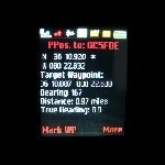
+dpbabcock Posted February 6, 2007 Author Share Posted February 6, 2007 I think your on a good track! You might consider different software for the differing needs of Individuals. For instance. I use my GPSr for surveying/mapping types of applications. I have no desire to use it for geocaching. Concentrate on one type of need, and make the best software you can for that particular need. Capturing point coordinates and moving them from a GPSr to a computer is critical for all types of users, as well as moving coordinates from a computer to a GPSr. In other words, keep the software short, sweet, and simple and targeted to a particular audience. Lots of software people have failed trying to do all things for all people. I agree 100 percent. And thanks for the advice, BTW. I'm just having fun mixing a couple of my avocations and my vocation. I'm a professional software engineer and general all around techie/nerd. Geocaching has become a fun way to have an outing with my girls (they love the "treasure hunt" aspects.) I built in the ability mark waypoints and edit/save them in the phone. I've written the download part so that I could directly work with my pocket query files from the geocaching site. It just uses the browser built into the phone for the data transfer. I've already mapped out the upload function. It will use either the browser and/or Bluetooth to "send" the waypoints in GPX format to the PC or a server web page. That seems to be a popular data exchange format. Fortunately, developing for cell phones kind of forces you to be focused. The devices don't have a lot of memory and storage and so you have to be "to the point" with your apps. It was a lark at first but it turns out that adding the simulated "sonar" ping feature based upon distance actually was quite useful. When I'm walking in the woods and getting close I can watch where I'm going while just LISTENING to the pings get faster or slower with the cell phone in my pocket (keeps both hands free for managing branches too) as I get nearer/farther from the final target. I've stepped in a few holes while focusing on the GPS and not where I was going (grin.) Plus it allows me to focus on LOOKING for the cache. I find those last ten or fifteen feet the most challenging! My wife thought I was nuts until she saw it work in the field (big grin.) Quote Link to comment

Recommended Posts
Join the conversation
You can post now and register later. If you have an account, sign in now to post with your account.
Note: Your post will require moderator approval before it will be visible.