Search the Community
Showing results for '다카마츠 자유 여행,합천부경샵【Talk:Za32】'.
-
That was just good old safety guy sarcasm. I can talk about geocaching safety ad nauseum, but it's usually met with crickets or worse, ignorance. You'll get 10k opinions on what's right. Figure out what's right for you. Remember to have fun and never forget about the danger of being outside.
-
I'm a retired safety professional and I've been caching since early 2003. I was and still am an advocate for a safety forum here, but this community is just for fun and it certainly doesn't really want to be reminded that outside is dangerous, and they certainly don't want to discuss the common types of injuries that occur and how to prevent them like every other activity where serious injuries can happen. Scuba, shooting sports, and skydiving are all good examples of communities firmly entrenched in safety, but don't suggest that we geocachers, as a group, talk about safety at events or forums because that's just boring. Right? I'm with the peanut gallery on cuts and scrapes. Some of the best finds and DNFs I can remember required a blood donation in the effort. I can remember returning to my car scratched up and bleeding having experienced a geocaching adventure that remains epic in my memory. The best being on a cache I had DNF'd for years and finally got. The other serious injuries and the occasional death can ALL be reduced or outright prevented through active awareness campaigns, but what users get here is a disclaimer and an implied hold harmless agreement. Outside is dangerous. Hunt at your own risk. Oh, and whatever you do don't die. Because that's all on you. Far be it from us to discuss what could have been done to prevent it so others can learn from it So here's my list to prevent the worst injuries and deaths I have seen in nearly 23 years of caching. Snoogans' Five DO's of Geocaching Safely DO - Be prepared for the challenges of each hunt (this one item could be a thousand pages long) That basically means reading and looking at maps and sometimes talking to previous finders or the hider. Most of the geocaching deaths I know of are from lack of preparation. MOST. DO - Hydrate, hydrate, flippin' HYDRATE. This is actually part of preparation too and this small consideration would have prevented many of the geocaching deaths I know of and for sure the first one that ever occurred DO - Wear Safety Glasses. From my research over a decade ago, the most common serious injury in geocaching is an eye injury. I wear safety glasses even for a skirt lifter. You just never know. (I was struck in the eye by a rock from a mower while doing a skirt lifter. I had just come off the trail from doing another cache in the woods and I still had my safety glasses on.) DO - Leave the wildlife alone. DO - Keep people informed of your whereabouts Do be do be doooo...
-
Instead of radio buttons, maybe a Personal Note for each log would do. The Cache Owner could keep notes for whatever purpose he chooses, and such notes could be listed and sorted. The note may be visible only to the CO. Or be publicly readable if that works better, talk amongst yourselves...
-
On the Challenge Talk Podcast last night there was a call for 1000 challenges to be published in June. Challenge GeoArt sprung to mind as my next project, and boy, a QR code GeoArt would be quite something. It begs the question: Is a QR code GeoArt even possible and what are the implications / limitations? You would want to do a micro QR code that was 21x21 pixels or something similar. All capitals and using a tinyurl.com link with as many empty blank pixels as possible allows you the fewest pixels / challenges needed. My current design is 217 pixels. The page you link to could be an issue since it could be modified to something the reviewers didn't approve. In my case I plant to update statistics on challenges, so there will be modifications, but all on par with the original content. It is possible a QR GeoArt could lead to something less savory, like a bad soccer team fan page. As with any large GeoArt, where to have it becomes a real challenge. Agricultural roads seem an easy choice, but lots of challenges puts a fair amount of Geo-traffic on roads that often are overran with harvest trucks, large farming equipment taking up both sides, and unimproved roads. Then you have how touchy farmers can be with people loitering around their equipment. Perhaps flat public land wilderness or sagebrush steppe, though that makes for an inconvenient series of hikes to get it all. Whaddaya think?
-
Guaranteed disappointment
funkymunkyzone replied to barefootjeff's topic in General geocaching topics
Careful GE6000, last time I brought this up, I got royally shot down, tarred and feathered by the purists who told me that new players should buy a GPSr and use the website! But no, I 100% agree with you. Some years back I was trying to introduce a new player - they were standing on top of a mountain and I was on the phone to them. I knew there was a cache within 10 or 20m of them, so I was trying to talk them through loading it up in the app so they could find it, with my remote assistance. They were an active hiker, so geocaching would have been a good fit. The app told them the cache didn't exist (because they weren't a premium member, so being a T3 or thereabouts, it was hidden entirely from them). It makes no sense to force them to use the website, see some coordinates and not be able to do anything with them on their phone standing on top of a mountain, when the app could be perfectly capable of introducing, and luring them, into the game. Instead, they walked away - no, not because they give up easily, but because it was apparent the game didn't want them to play. I haven't checked lately if anything has changed for new basic players in the app, but it sounds like it's still unnecessarily restrictive. -
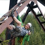
That sounds like an awesome project—I love the idea of a full power trail of 5.0 difficulty hides! One idea that came to mind for something unique and challenging is this: A camouflaged cache placed high up in a tall tree. Not just slightly out of reach, but something that requires climbing gear or a clever retrieval tool. You could disguise it as part of the tree—like a knot, a chunk of bark, or even a fake bird’s nest—to make spotting it just as tricky as reaching it. It would definitely push the “5.0” boundary both physically and mentally. And if placed in a safe location (like a climbable tree away from busy paths), it could be an epic part of the trail that people talk about long after. Other ideas could be: A cache hidden inside a hollow log or stump with a super well-hidden latch A gadget cache that needs tools or a sequence to open A fake utility box or sprinkler head that blends perfectly into the surroundings Can’t wait to see what you come up with—love that you’re aiming for variety instead of repeating one trick. Keep us posted on your hides!
-
TB9GB8G - WISA WOODSAT - the first wooden satellite in the world
Voutar posted a topic in Trackables
Greetings from the WISA Woodsat HQ! After the announcement of WISA Woodsat satellite trackable (TB9GB8G) mid August, we have over 6200 people on the watch list! That also means that I have received a fair amount of messages regarding the satellite itself, the procedure of logging it, launch schedule and many others. Unfortunately I am not able to answer them one by one, so, let's talk satellites in this discussion thread. The most common question is, how you can log the satellite trackable. I have added the instructions to the trackable page https://coord.info/TB9GB8G. The thing to note is that you can only do that AFTER the satellite has been launched. The trackable code is only visibile in the photos taken by the satellite itself with its selfie-camera. You can follow WISA Woodsat project progress on https://wisawoodsat.space. We have blogs and videos showing how the satellite materials are made, how they are machined, and tested. You can also find WISA Woodsat on Instagram and Twitter with the handles @wisawoodsat and #wisawoodsat. Anything else you would like to know about the satellite? -
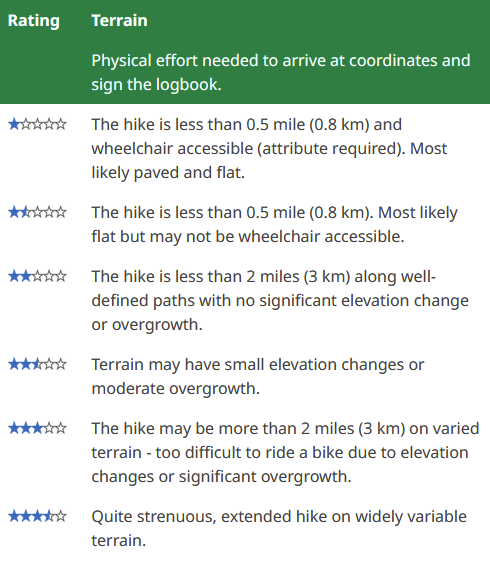
Unfortunately the Help Centre page on cache ratings is a bit ambiguous on this: At the top it says "Physical effort needed to arrive at coordinates and sign the logbook" but the individual desciprions up to and including terrain 3.5 talk exclusively about the hike.
-
Sad I missed @bootron last night on the Geocaching Talk Network's livestream about everything Waymarking. Just watched the recorded video and it was interesting seeing the history of the site and how it has grown over the years. Thanks bootron for everything you do to keep both Geocaching and Waymarking possible! Hopefully more people will start Waymarking For those wanting to watch the recorded live stream, here's the video link:
-
- 4
-
.png)
-

-
Well I managed to get the Finder souvenir with half a day to spare, but talk about doing it the hard way! With no unfound caches close by, I spent last night poring over the map and decided on a couple of fairly easy traditionals in central Sydney I hadn't done yet. I set off by train this morning, not realising that trackwork this weekend meant they weren't running all the way to the city, so I ended up on a crowded metro for the last part of the journey, then an even more crowded light rail to get me close to the caches. After battling through yet more crowds on foot, I reached one of the caches only to find a couple of muggle families sitting virtually on top of it eating lunch. Not wanting to wait, I set off for the other cache a few hundred metres away and fortunately in a much more muggle-free spot. Phew! For the Hider souvenir, I'm starting to put together a multi I've been mulling over for some time. There's a scenic headland that's been opened up by a recently archived 2010 cache so I went exploring a week or so back but ran out of daylight, then it rained almost non-stop for a week. I got back out there yesterday afternoon, confirming my two waypoint locations and a couple of options for the final. I'd intended using a 1.3 litre Duratech instrument case as the container, but my preferred hiding place really requires something bigger so tomorrow I'll be going out hunting for ammo cans. Once I've settled on the hiding place, I can then start putting together the two waypoint objects that will reveal the final's latitude and longitude respectively. With another period of extended wet weather forecast to move in from Thursday, I'm not sure if I'll have everything ready by then as some of the preparation will involve waiting for paint to dry, but maybe there's still a chance it could be published before the souvenir runs out at the end of the month.
-
It will be in ROW of county road with a fair amount of traffic right now due to construction. 1. My idea is to have a piece of hardware attached to a tree holding one object needed to get the cache out of its hiding place. Another object needed will be hanging in the tree in plain sight until the tree puts on more leaves. And finally, a false limb needs to be pulled off to get to the cache. It’s pretty obvious right now too. Is this too complicated for just a bison hide? The description will have clues as well as the title. Of course if most people bring a box of tools, they can bypass the two objects and go straight to the false limb if they see the cut mark. 2. Before your first hide that was more than a simple drop, did you have anyone try it out to see if it worked as planned? I don’t know any local geocachers, so would have to talk a friend into it and give them a crash course. 3. Do you put your log in a zip lock inside a bison? It’s supposed to be waterproof but I haven’t tested it. I can put in a bigger log if I leave out the ziplock. Thanks!
-
You didn't say what your offer is. Your project creates a comparatively huge device. An advantage of Chirp is that it's ultra-compact and easy to hide. The idea is that cachers would never find the device itself, because a Chirp's range is pretty much the radius of a cache placement, and Geocachers are good at finding things. If people are finding it, there's no way it lasts "10 years". Assuming you've addressed the issue of making your big transmitter muggle-proof, you might as well abandon Chirp. Chirp doesn't talk to iPhone, while "Air Tags" (for example) are an exclusively iPhone thing. Many Garmin GPSrs do not support Chirp. Phone Apps allow anyone to edit or erase all of a Chirp's data. My Chirp caches routinely got “edited”, which not only prevented Garmins from accessing the Chirp, I had no control over what people posted. And it's a pain to reset and re-program the Chirp, when I had the expectation of not handling it for at least 6 months at a time. Maybe try “Tile”. Or see the "BLE" devices and beacons mentioned in this thread. Or find a super tiny generic “Bluetooth” device that allows you to customize its identification, where at least anyone with a smartphone could view some short text without pairing. Better yet, hunt around Ali Express for a micro Wifi router, maybe one with “beacon” or “kiosk” capabilities. Then you'll need to consider solar panel size and batteries. Or look at NFC tags/cards. I have a pack of cards that are programmable. They work at short range, but can be set to "Read Only" and/or password protected, need no batteries, and many current phones can read them. I have ideas for diabolical ways to hide these as cache stages.
-
Indeed. To hear some talk, you'd think that there weren't any filtering mechanisms available for developing a caching run that better suits someone's style v.s. "all of the above".
-
i know that there are furries all over the world. i am also aware that a few of us geo cache. so i thought this could be a place we could meet and talk on line. so who else is out there * waves*
-
Geocaching Skills Competition Event
Weber_and_Sons replied to Weber_and_Sons's topic in How do I...?
I was not planning on listing these on the website I was gonna find the spots the week before then hide them and then once everyone leaves I would take the containers and probably reuse them for future geocaches. The multicache was not gonna be the focal point rather an activity during or after a bonfire or a potluck. The reason it probably seems like the focal point is cause that is the only part of the event that I needed help with (which is why that part of the event is all I talk about.) I have realized since posting this that its is flawed and needs some work. -
Disabling cache during Mega-events
Overused replied to Overused's topic in General geocaching topics
I dont think the rule work like that, its suposed to make events for finding caches, this is cache next to event not even connected to it. Not gona talk about this rule is being ignored on nearly every mega event as owners publish new caches with FTF friendly, especialy here in czech to give attenders FTFs... So then the mega is made to find caches which is against rules.. -
This is a place where EVERYBODY can talk about the Hoosier state. Feel free to talk about TBs, Geocaches, GeoArts, etc., but keep it within Indiana. Thanks!
-
Downward Trend of Geocaching, and possible solutions!
cerberus1 replied to Inmountains's topic in General geocaching topics
I don't know... That 'covid' scare still has some folks worried about people, we're still seeing people with masks (that did nothing...), when some of us were playing outside with no crowds. '24 was a really crappy year for weather. and this is March where we're seeing 75-degree weather today, when it should be 50. Go figure... I talk to quite a few who got into health issues the last coupla years. So that might have a couple missing too. The hobby is 25 years older, and we aged with it. I'm gonna be cleared to play some in a couple weeks. A lot lighter now, so it'll be interesting to see how I fare. Over the years it's always been kinda up n down in interest here. From May into Summer should give you a good idea on interest. -
I don't think geocaching is dying, most people i talk too know what it is. in fact i started last year and am a new geocacher my self
-
If you're looking for Challenge ideas there is a wealth of inspiration on the game board. https://project-gc.com/forum/list?11 is the challenge checker forum thread for completed checkers - these will be the ones that are approved within the guidelines, built, and either live or about to be published. You can also check out the Challenge talk podcast and browse the fun stuff they talk about there. They highlight a list of challenges every month toward the end of each episode. If you want to build something new and not using inspiration from existing ones, you could check out some tools from that show: "the challenge builder 200". It's a list of different things you can combine together for challenge requirements. You can get real nerdy with it and use "The gridbuster 4000" that charts out different combinations and try to link examples of ones that have already been published. The video of that podcast episode explains it a bit but the accent is hard to understand. https://www.youtube.com/live/ddQI4qJLV9U?t=1011s
-
Hello! I'm working on creating a new Category for Wind Phones. What are Wind Phones? Wind Phones are telephones set up for the public to visit and talk to relatives who have passed away as a form of grieving. The original wind phone booth was set up in Japan by Itaru Sasaki in 2010 and became a well known grieving spot after the 2011 Tsunami disaster. Since then there are over 350 wind phones have been created according to https://www.mywindphone.com/, with locations in the US, Canada, Europe, Africa, Australia and New Zealand. The movement seems to be growing in popularity with a Google News search showing a new story about them every couple weeks. Although mywindphone.com has a comprehensive list, there are other websites such as thetelephoneofthewind.com that exist. Let me know if you would like to be an officer or any other input. Category Group: https://www.Waymarking.com/groups/details.aspx?f=1&guid=8876c565-5cb5-4199-8f5d-83f7c048ed9d&gid=6 I created an uncategorized waymark based on my own Wind Phone visit here: https://www.Waymarking.com/waymarks/wm1BG0C_Riverside_Park_Wind_Phone_Detroit_MI
-
How about a GeoAchievement Badge for continents
niraD replied to poosu's topic in General geocaching topics
I had no idea what you were talking about until I looked at your profile. The GeoAchievement Badges on your profile were created by MyGeocachingProfile.com so you need to talk to them if you want them to add a new one. -
Session expired - Need to log in again
Sol seaker replied to Its_Dozzie's topic in Official Geocaching® apps
I came in here to talk about this, and found a thread already set to go. The funny part is as I was reading this thread I got logged out of the forums for no reason AND i'M ON MY COMPUTER. lol Anyway, I have an apple phone and I keep getting logged out of my account on the web when I switch to that. I've been running the checkers to see if I qualify for challenges. I run the checker. It says I have to authenticate, so I do, and then it puts me into the main menu on Project GC, rather than going back to the checker after I authenticate. I guess this is different from above, but similar. So then I'll go back to the cache page and try it again and once again it says to authenticate, and when I do it puts me into project GC again, but not on the challenge checker page. I keep going back and forth and after about the 5th try it finally gives me the challenge checker, but each time I have to RE-SIGN INTO MY ACCOUNT. It didn't used to do this. drives me nuts. Does this make sense? -
Oh! Don't leave! How did you get started? Did anyone walk you through it? Did you talk to any other players, or did you just come across the app and start on your own? Have you been through the HELP section of the website? Are there local EVENTS in your area where you could meet cachers and learn how to approach caches, and what to do if you don't find them?? If you break through that first one and learn how to THINK like a cacher, it can be tremendously rewarding. So, don't give up and don't go it alone! After all, you've ALREADY got a cool caching moniker! Shame to see it go to waste. Anybody else wanna jump in here?
-
I have one where I needed permission from town council and the local Rotary Club who built & maintain the nice boardwalk to GZ. It wasn't particularly difficult to get permission and also didn't take too long, but the Rotary Club asked me to come to a meeting to give an informational talk. It wasn't a condition of permission, but I felt compelled to agree.


.png)


.png)


.png)