


A tapeworm
-
Posts
62 -
Joined
-
Last visited
Posts posted by A tapeworm
-
-
Hmmm ... Scouts ... searching for & maybe finding elusive things ...
Snipe hunting in the microchip age?

-
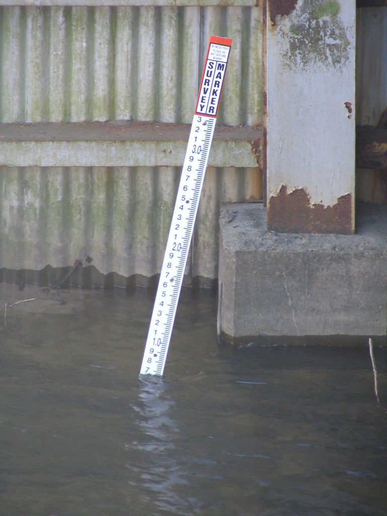
... the county decided that a curb was not enough to to keep cars out of the canal and placed a concrete barricade on top of the curb. They managed to cover part ...
Lots of those in my area, including two a half mile apart: NF0458 and NF0440.
NF0458 gets bonus points for Stupid Witness Post Tricks, too:
-
...
Finding information on the reference marks is easy if you get the NGS datasheet. Amidst all the jargon and numbers is what is called the "box score" which tells you how far and at what angle each of the reference marks is located.
...
Are there other ways to use azimuth in this situation? Specifically, I've been befuddled by OK0603 :
Documented History (by the NGS)
1/1/1931 by CGS (MONUMENTED)
... STATION IS 10 METERS (33 FEET) SOUTH OF CENTER LINE OF ROAD ... REFERENCE MARKS ARE STANDARD REFERENCE DISKS IN CONCRETE, NOTE 11A. NO. 1 IS ON NORTH SIDE OF ROAD, 2 METERS (7 FEET) SOUTH OF FENCE LINE, 18 METERS (59 FEET) WEST OF SOUTHEAST CORNER OF ORCHARD, AND APPROXIMATELY 100 METERS (328 FEET) FROM STATION IN AZIMUTH 259 DEG 20 MIN 05 SEC. NO. 2 IS ON NORTH SIDE OF ROAD, 3 METERS (10 FEET) EAST OF EAST END OF GATE LEADING TO RAMBLING HOUSE, 7 METERS (23 FEET) NORTH OF CENTER LINE OF ROAD, AND 22.11 METERS (72.5 FEET) FROM STATION IN AZIMUTH 147 DEG 31 MIN.
If the station is on the S side of a road running pretty much due E-W, how can following an azimuth of 259 deg (RM1) or 147 deg (RM2) bring one across to the N side? The mark referenced is now gone, but a few years ago it was indeed present on the S side (when I photographed it as an example while teaching topo map reading to Science Olympiad kids!)
-
... the mark was not recovered in 1982 by the NGS, which whetted his apatite.
Whetted his apatite?
You rockhounds....

-
Read the first post on this forum page [Pinned: Me First!] It summarizes nicely how to start here.
To reply to a message on this page: click [ " REPLY ] in the bottom right corner.
To reply individually by email: click on the writer's name (underlined/hyperlinked).
Ask lots of questions 'cause there might be a prize if you stump the smart guys.

-
Generally, a right-of-way marker will not appear in the database, except as a "reference point" for finding a benchmark. However, there are exceptions, such as when a R/W marker is used as a support monument for a survey point. In these cases, something is added to the R/W monument to indicate the precise spot to be used by surveyors.
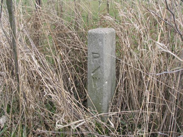
Yeah, that's what I figured. The other faces of the monument are all smooth - no evidence of previous disk/rivet/etc.
Thanks, all.
-
While out searching benchmarks today I came upon this post where the topo map noted a vert control mark (which I never did find). I presume R/W chiseled into the concrete denotes "Right of Way" but I haven't seen other similar structures in this neck of the woods (Kent County, SW Michigan). No listing @ geocaching.com. Any other ideas?
Thanks!
-
If you're a premium member, then you can search by lat-lon and get a listing and map of what's near those coordinates.
If you're not, then you can put in a town and state and get the map but no listing. You can get to look at a waymark from the map, though, by clicking on a marker on the map.
Got it. Thanks!
-
If you don't find the mark you found in the geocaching benchmark database, then you can log your benchmark disk find on the Waymarking site for U.S. Benchmarks, also run by Goundspeak.
Thanks, BDTs. I've logged other NGS benchmarks on the GC site, but the USGS mark wasn't listed. The Waymarking site it'll be, then - once the snow melts a bit so I can get a decent digital pic. I'll fuss some with the site to get more familiar, but it doesn't seem especially user-friendly at first glance - I wish one could search by Lat/Long, for instance, rather than by most recent find....
Thanks again
[urban search in fescue? Thank you very mulch.]
-
Please forgive me if this is a FA(newbie)Q:
Is there a website to log findings of U.S. Dept of the Interior Geological Survey benchmarks ? Thanks!


Sometimes it isn't about the bench mark
in Benchmarking
Posted
When that's happened to me (NF0336) I get that same joyous relief - after I've looked around to be sure no one's been standing there watching, ready to point out, "It's been right there - duh!!!"
Dunno what I'd say if that ever happened - hopefully something like "Well yeah, but I've been looking for the hidden one!"