


DENelson83
-
Posts
510 -
Joined
-
Last visited
Posts posted by DENelson83
-
-
How 'bout this one?
Gee... (What you say when you can't find it)
...oh! (What you say when you found it)
CASH! (What you say when you're the FTF [well, sometimes, anyway...])
Or this?
Five out of five terrain. It puts the "ache" in geocache.
-
With this new series of Garmin receivers, we have some new toys to try out, such as 3-D buildings, geotagged photo navigation, and something called "Lane Assist," which gives you a virtual view of the road ahead complete with road signs.
https://buy.garmin.com/shop/shop.do?cID=133..._SERIES_NUVI705
-
If you're going to make a crossover GPS unit that is meant for both road use and trail use, it needs to have the sensors on it (magnetic compass, pressure altimeter). The Nüvi 5xx's have neither of those.
-
Heck, I've been able to get sub-two-metre accuracy on a 76S.
-
Did you look at the nüvi 7x0 units? They provide voice directions.
-
When you turn on the unit, go to the menu button at the upper right corner of the screen, next to the page button. Then select "new location". Choose "automatic" to put the unit into AutoLocate mode, or choose "use map" to tell the unit to adjust its almanac based on your current location.
-
Well, when it comes to 6.14.1, one word comes to my mind...
FAIL.
-
It must be published to be reserved.
-
Mid-Island Geocachers has adopted the stretch of British Columbia Highway 19A between Royston and Courtenay.
-
Make sure you're standing far enough away from any metal objects and that you are holding the unit as horizontal as possible while you're calibrating the compass on your 60CSx.
As for your accuracy problem, try using freshly-charged batteries, make sure "Battery Saver" is not chosen, and that you are holding the unit vertically to get as accurate a fix as you can. You might also try turning on WAAS.
-
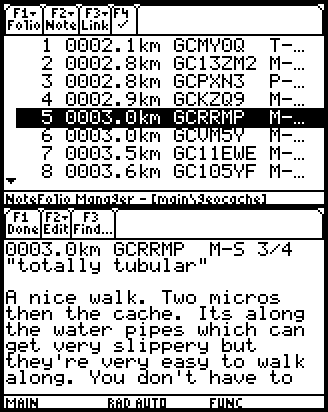
I've heard of all these programs and macros out on the Internet that are supposed to ease you into paperless geocaching, such as GPX Spinner and GSAK, but I'm one of those people who prefers to just compile and load up the information manually. I use a TI-89 Titanium graphing calculator with NoteFolio software as my paperless geocaching aid, and I have a program on my computer that will allow me to create note files that my calculator accepts, so I don't have to tediously type them into my calculator. I simply choose the geocaches I want all the info for, manually cut and paste them into a file (one note per geocache, with one file able to hold many notes), then just upload the whole file into my calculator, and presto! Paperless geocaching!
Here's what the geocache information looks like in such a file on my calculator:
Has anyone else out there chosen to eschew such esoteric macros and just manually transfer the geocache info onto his/her paperless geocaching aid?
-
Maybe it uses a different map datum, one not listed in MapSource?
-
A laptop? Isn't that a bit bulky to take with you to a cache site?
If you have a Bluetooth receiver, see if you can get yourself a cell phone with Bluetooth capabilities.
-
I continue to use MetroGuide Canada because it has more accurate coastline data than CN 2009.
-
The reason the UK looks stretched on 6.14.1 is the same reason the Equator would look compressed; because as you pan the map north or south, the east-west scale does not change, as it did in 6.13.7. That feature needs to be put back.
-
The 76CSx is basically the same as the 60CSx, with two advantages; one, it floats on water, so if you go out fishing in deep water, you won't lose it; and two, you don't have to remove the batteries from the unit to change MicroSD cards.
-
The 76CSx, the model I use, has a S★III high-sensitivity receiver chipset, and it meets my geocaching needs quite well, plus it floats on water, in case you want to go boating and want some piece of mind that you won't lose it overboard. I still don't trust that the Vista HCx has had its odometer bug fixed, so if you want to be sure that the odometer readings you get are accurate, the 76CSx is what you should get.
-
From what I've read, I would trust the S★III chipset in the 60CSx much more than the MTK chipset in the Vista HCx.
-
Garmin Alberta:
Feels like oozy sand and fills your gas tank while you drive.
-
That should also be in the options menu on the compass page.
-
I believe you simply need to start active navigation to gain access to the bearing/course pointer option. No Sight 'N go is required.
-
Another quick compass question on the CO 400t... When I was playing around with my first unit the red compass arrow had a section that would break out moving off left or right. I was intrigued with this presentation as it reminded me of an aircraft VOR. With my first replacement now (I'm not hoping for any others) I've been unable to get the compass arrow to function this way. What was that mode--How do I get it back should I prefer it?
Oh, course pointer? It should be in the options menu on the compass page.
That's funny. This led me to Compass | Options | Sight 'N Go | Lock Direction | Set Course and low-and-behold...there is the compass decked out to look/function like an aircraft navigation VOR (VHF Omni Range).
Does anyone know why there is a "0.25 mi" just outside the compass wheel in the upper right? Its value does not change--or at least I have never seen any other value there. I wonder if it might be the distance between the dots to estimate how far off course you are?
Thanks. Now...how do I get rid of it if I want to revert back to a normal looking compass? Seriously, I couldn't figure out how to revert back.
Compass | Options | Bearing pointer. That's how you switch to the regular looking compass.
Compass | Options | Course pointer. That's how you switch to the VOR-looking compass. You don't need to use Sight 'N Go to get it.
0.25 mi is the distance between dots on the CDI (course deviation indicator). You can change that by simply zooming in or out.
-
I don't know that particular unit, but I think every Garmin gps with a barometric altimeter has a hole in the case - the altimeter won't work without it.
It's called a "pitot" intake. All altimeters have them. My 76CSx has one.
-
Another quick compass question on the CO 400t... When I was playing around with my first unit the red compass arrow had a section that would break out moving off left or right. I was intrigued with this presentation as it reminded me of an aircraft VOR. With my first replacement now (I'm not hoping for any others) I've been unable to get the compass arrow to function this way. What was that mode--How do I get it back should I prefer it?
Oh, course pointer? It should be in the options menu on the compass page.
You can take a heading with a GPS
in GPS technology and devices
Posted
Yes, your sensorless GPSr, such as an eTrex H or GPSMAP 76, can give you the direction you're facing while you're not moving.
You get a clear view of the sky and a relatively accurate fix, and then just take the part of your GPS that contains its internal antenna, aim it towards the sky, and then suddenly jerk the unit forward a considerable length, such as ten centimetres. The heading field on your GPSr's screen will then give you the direction in which you jerked the antenna forward, accurate to within about fifteen degrees. This technique is called "casting a heading," because you manipulate the GPS like you would with a fishing pole when you cast it.