

CallawayMT
-
Posts
379 -
Joined
-
Last visited
Posts posted by CallawayMT
-
-
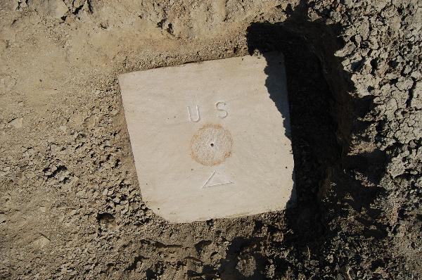
That is absolutely the BM X on the historical quad map. The early 1900's monuments that were attached to boulders were many times Aluminum. That is a great find and the fun is trying to these older monuments from the historical quad maps. The elevation stamped is from the original datum and almost always changed with closing loops and changing datums. That is the reason that elevations were not stamped on the monuments over time to alleviate a different elevation on the monument than what was found in the records.
Here is a good place to understand how to search and what to search for:
http://www.penryfamily.com/surveying/usgsfindmaps.html
Nice job!
-
About 8 years ago there was someone who kept statistics of all of the Benchmark finders. Furthest North, South, East and West; most finds, highest finds, etc. He did make it fun to try and outdo others. I don't know if he is still around or his website still available.
-
Here is your conversion complements of NGS. The upper Lat Lon Numbers are in Degrees and the lower Lat Lon numbers are in DMS.SS. Assumptions based on your location are WV state plane US Feet due to state unit statute and zone based on your location. If it hits where you expected, we guessed right.

-
Those appear to be state plane coordinates. They can be converted, but I would need to know a general location for your monument which would help with the state and zone needed to convert them.
CallawayMT
-
Hey foxtrot I use your Google Earth plugin daily, but it has not been working lately. It appears you changed your server and I can't even find your information anymore. Are you keeping the GE plugin operational?
Thanks for your work over the years!
-
On 2/25/2018 at 5:46 PM, Michaelcycle said:
I stumbled across one of these General Land Office Survey markers while geocaching in the area of the Jornada Del Muerte last week (sounds more dramatic than east of Hatch, NM) I thought the rock with the chiseled cross was an interesting addition.


Michaelcycle,
You didn't make it easy by your description of where you were located, but here are the original GLO notes describing your corner including the placing of the stone with the X on the west side of the corner.


Nice find!
Kurt
-
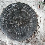
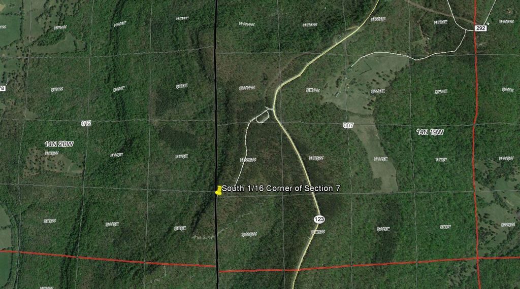
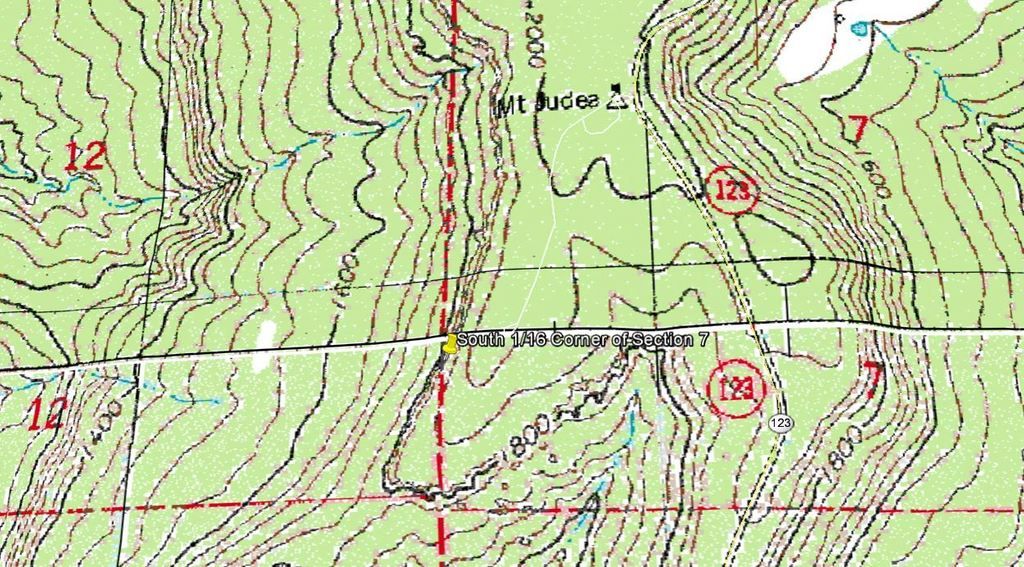
Clay as Kayak indicated, you found a land ownership corner. 99% of these are not in the NGS database and cannot be logged in this arena. You specifically found the South 1/16 corner for Section 7 and is a part of the Public Lands Survey System (PLSS). This is the base system for the majority of the land ownership system in the majority of the western U.S. This is a unique location that can be very easily identified as I am showing in the aerial and quad images:
Happy hunting!
Hi all - I recently found a marker near a very popular camping area in northern Arkansas. I have searched for it in the database on this site but can't find it. I have the lat/long coordinates for it and below is a link to a photo of it.
Any suggestions on how to find this?
Thanks.
Here are links to the images:
-
I just went out today to track down my first benchmark, which I found in the middle of the intersection of Santa Monica Blvd. and Palm Drive in Beverly Hills! It took me a while to find it... and to be honest, I'm not so sure it's the right one. I'm certainly no expert yet!
I'm a skeptic of the post, too, given the date. Would the Wall Street Journal really have a reporter assigned to cover a non-business topic like benchmark hunting,
The funny thing is the Wall Street Journal actually interviewed my friend Jerry Penry just this past week in regards to his many monument searches and stories.
-
As I was driving thru my hometown today, I caught myself relooking at benchmarks I have found previously. I seem to do this a lot on many places I know exactly where the mark is at, when I drive by them. It's like I'm vigilantly watching over them for some reason. Does any other of my fellow benchmarkers do the same, or am I just the freak who needs professional counseling?

It is a sickness that has no remedy! Our wives just learn to deal with it.
-
Finally had another excuse for a long, hot, dusty drive into the Missouri Breaks.
Should have checked on it three years ago when I could have paddled right to it instead of crashing through the 1/4 mile from today's nearest kayak landing. Or waited for a month until the bugling Wapiti come off the CMR NWR ridges and beat out some trails to the river. MEL
Mike do you have a photo looking at the bank with the stone exposed? Nice work, as always. I'm glad to see you are still at it.
Kurt
-
I have a picture of a PLSS marker located in Haw Creek Falls, Arkansas without the coordinates that go with it:
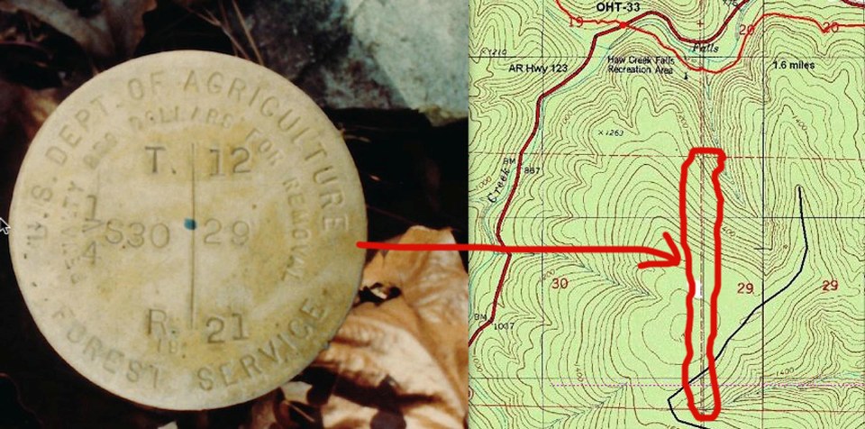
Is it possible to figure out the coordinates where it should be? Closest coordinates given were probably within a few miles, I believe (N 35° 40.584 W 093° 15.324) - Being an Easterner, I'm not really up on the TWP/Ranges grid, although I've read over some of the charts

The best available information for the most probable location of the PLSS corner monuments was derived from the GLO record information which was then adjusted to good and not so good controlling corners. This information was then least squares adjusted using Geographic Measurement Management software and generally by the BLM or a private contractor for the BLM. This information can be retrieved as shapefiles from GeoCommunicator.gov. I downloaded the shapefile and queried that corner and here are the NAD83 DMS geographic coordinates: 35°39'53.79"N 93°15'15.35"W.
Another way you can do it is to go to:PLSSGE and you can search corners by TRS or other searches and zoom into Google Earth to get the value. This GE plugin is using the shapefiles created by the GCDB to generate the PLSS linework onto Google Earth.
Kurt
-
Does any documentation exists that lists all the triangulation stations placed by the Missouri River Commission? I have the "Descriptions and Elevations of Bench Marks on the Missouri River", which lists all the bench marks and references the triangulation stations. It only references the triangulation stations by number but doesn't provide a list of their locations.
I accidentally found a MORC triangulation station and I wanted to figure out which one it is and possibly locate bench marks near it that reference it. the one I found is in St. Charles, Missouri.
Thank you,
Chris
The place to find the Missouri River Commission Information is in the old Report of the Chief of Engineers, U.S. Army, Appendix AAA Report of Missouri River Commission, December 9, 1884 covers a few states and Triangulation Station Descriptions. You will probably have to go to a good library to find these reports from various years in the 1880's. Here is a link to the maps created by the Commission and you will see triangles indicating the Horizontal Control Stations.
Jerry's book is very well written with a lot of good MORC information. You might consider purchasing it here:
Good Luck, Kurt
-
Is it relatively common to find the old tower structures like this in the lower 48?
I don't know about others, but we have only found 3 or 4 of the wooden towers in the almost 1400 recoveries we have done. We are always excited to find such things.
John
Here is the tallest standing tower that I have seen, probably 25-30 feet tall:Ambrose
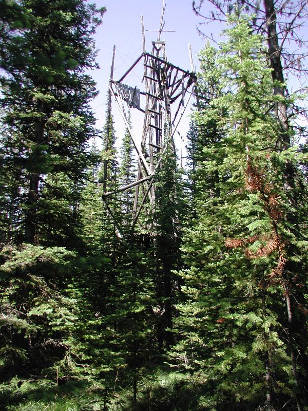
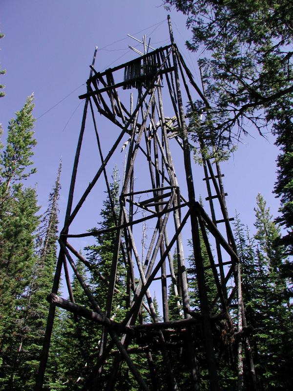
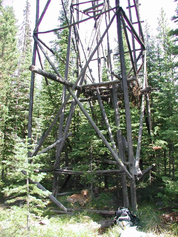
Kurt
-
If anyone is interested, here is another great article by Jerry Penry on the USGS Deadwood Datum.
-
With a self-imposed travel restriction due to the extreme fire danger in most of my Montana old bench mark target area I've had
time to read 'Packets to Paradise, steamboating to Fort Benton 'by John G. Lepley.
available on line: http://www.fortbenton.com/museums/bookpages/lepleypackets.html
Five of the 148 steamships that docked at Cow Island or above from 1860 to 1890 had MORC triangulation stations named after them.
CHIPPEWA 12 MI BELOW FT BENTON 1859, FT BENTON 1860
One of the earliest boats above the Yellowstone River (RM 310 on the 1894 MORC maps, measured along the channel from the Bismark Bridge)
and my first packet name logged, ST ANGE, made it to the Poplar River (RM 407.6) in 1851.
And my favorite recovery only made it to the Musselshell River in 1867 where it ran aground and was abandoned.
JAMES H TROVER AGROUND AT MUSSELSHELL R. 1867
Seven more Tri's are near named rapids and a bunch more at prominent landmarks.
The last commercial steamboat reached Fort Benton in 1890, yet the Corps of Engineers continued to run a snag boat until 1921; and a railroad lift bridge was built about seven miles above the Yellowstone confluence at Snowden in 1913.
http://en.wikipedia.org/wiki/Snowden_Bridge
Great History! kayakbird
Thanks for the history Mike! We haven't talked in awhile, have you had a chance to stop at the Headwater's to see if North Base went downstream since last year? I'm sure it did, based on my last view of it and how high the rivers were last spring.
Talk to you sometime soon.
Kurt
-
jxavierf,
If you have a question then you should call the surveyor and ask him how he created the certificate. You need to be using the correct datum to begin with; NGVD29 or NAVD88. Those two datums are approximately 2-4 feet different in many parts of the country.
Without running a level circuit or a very precise GPS elevation to your house; you are just guessing what your elevation really is. More than likely you do not have that type of equipment or expertise to perform an elevation survey on your own, so you would need to contact somebody who does. The techniques that you used are probably in the neighborhood of 20+ feet in accuracy and are very unreliable.
Give him a call and he should be able to answer your questions.
Kurt
Hi all. Have a conundrum. I have an elevation certificate from a local surveyor here in Mount Pleasant, SC. The The benchmark used is from 1929 and the findings indicate that the base of my house is 4 feet below sea level. What is interesting, is that if I cross reference the following sources, 1. http://www.daftlogic.com/sandbox-google-maps-find-altitude.htm
2. Google Earth
3. http://www.gpsvisualizer.com/elevation
I get an elevation between 0' and 1'. So the surveyor says -4', yet the above three sources indicate between 0' and 1'......could the benchmark be wrong? And if so, how do I challenge this...who do I contact.
TIA!
-
Edrik,
The PLSS data that you are getting from the Geocommunicator website is created using Geographic Coordinate Data Base (GCDB) software. This software uses the historical GLO and BLM record information and coordinate geometry for creating a least squares estimate for all of the PLSS data across the country. When you download the shapefile you are getting all of the 1/16, 1/4, section, meander, mineral and other special survey corner locations along with line intersections; so you are getting a lot of extraneous corner locations which were never monumented, but they still have a corner location. The thing to remember in surveying, is that a corner (a record or calculated position) is created upon survey, but a monument(which is a physical object) was not necessarily placed at every corner location.
Some state BLM offices supply the GCDB flat files which can be manipulated using WinGMM and other softwares to clean out all of the extraneous (un-monumented) PLSS positions. Here is a good place to look for software if you want to experiment with PLSS data: Kurt Wurm GCDB Software
In Montana I use his LX2GPSX software all the time to create a quick search file for handheld or even survey data collectors by township and I can run the raw data through GMM to clean out all the extra corners I don't want to load. If I want to visually see the PLSS grid on the Garmin receiver, I have also downloaded the shapefile as you have been doing and convert that to a track or route to load on the units.
When I have been out across the country for work and pleasure, locating the PLSS initial points has been a hobby of mine and last week I went to my 17th initial point at the Fairbanks Intial Point in Alaska. I visited the Michigan marks back in 2006 and they have been fanciest remonumentation of any I have been to, unfortunately they remain difficult to get to. You can see my post and photos for them here: Michigan Intial Points
I haven't looked at Michigan, but many states and counties across the US do have websites where the PLSS corner monument Corner Perpetuation or Certification Records created by Professional Land Surveyors are stored and available to view which would tell you what the monument is and information to find it. You are correct in the fact that there are many publicly accessible monuments located throughout the US to find, always remember to leave them as you find them for the publics best interest.
Kurt
At the moment I'm using a Windows Mobile 6.1 AT&T Tilt smartphone with the Cachebox Geocaching program. It uses OSM map tiles and would not use a Garmin overlay map. (I'm thinking about getting an Etrex 30 in the Fall/Winter though.) I also sometimes use a Garmin Nuvi for Geocaching/Benchmark hunting, though I've yet to use it for PLSS marks. I do have MapSource & Basecamp though so I will take a look at that map overlay.
I originally downloaded PLSS grid shapefiles for my state and converted them to KML files so I could have a PLSS grid overlay in Google Earth, and that works pretty well, though with the whole state's grid up it slows down when zoomed out. Unfortunately GE's usefulness is limited when without internet and I can't put it on my phone.
I then tried to make a database of possible PLSS locations for my phone by converting the KML file to CSV, the CSV to LOC, and importing into GSAK. However the state wide file seems to be too big for GSAK. So I tried just doing one county and managed to do it. (Over 4000 possible locations in my county alone.) However not all those locations may actually have a PLSS mark. (I believe the waypoints created by this method include every intersection of lines from the grid, but some of the intersections may not actually be section corners/quarter section corners but intersections where the grid was subdivided into smaller sections.
Before I used that info to actually go out and look for markers, I found out that there's an online database for my state where the remonumentation project data is stored and that has proven to be a far better location reference tool since it doesn't just say where marks are, but what they are and what kind of witness marks are near them. (Even though I'm not totally sure how you read the witness mark direction/distance info.) Interestingly, the original description for a lot of these section corners use ancient measurement standards that I didn't know existed before, like Chains, Links, and Rods. The newer descriptions usually use more modern standards.
Here are links to the "Land Corner Recordation Certificate" pages for the two corners that mark the beginning points of the Michigan PLSS grid. The monuments there are rather impressive compared to normal. (The grids don't quite line up east/west of the Meridian so there are two monuments, one to the North, one to the South, and both within a unique undeveloped and land-locked state park.)
North:
http://www.dleg.state.mi.us/remon/dt_image.asp?remon_index=01S01EA0120041206&directory=01S01E
South: (2 pages)
http://www.dleg.state.mi.us/remon/dt_image.asp?remon_index=01N01WM1320071106&directory=01N01W
Since the info sheets above are really just TIFF images, to get that info into GSAK I end up having to type it in, so I don't copy all the data just the data I think will be useful to find the mark, and I print the sheet out so I can have the full info with me. (Some of the sheets I've seen have drawings of how the monument was found and how it was remonumented.)
The one thing these sheets don't have is GPS coordinates, and that's where this website comes in handy:
http://www.earthpoint.us/TownshipsSearchByDescription.aspx
The website that got me started on all this (and where I believe the data for your overlay map came from) is here:
http://www.geocommunicator.gov/GeoComm/lsis_home/home/
There are a few PLSS marks that are in parks and, assuming I can locate them, I may turn them into Waymarks so others can find them too.

-
My guess is that these were mis-quoted as being Missouri River Commission versus Mississippi. They even call the stone as being US Geodetic Survey versus what should have been Geological Survey.
Kurt
-
Bill93,
My vote would be for a Data Sheet clerical error(s).
GSAK filters out 15 "BOLT"'s placed by DOD. Didn't pull up all the DS's but suspect that most have an 'UNK' date and were actually part of, or incorporated into, the late 1890's Mississippi River Commission Survey.
I see no evidence of a disk impression and the stamping & leading technique fits the above time period.
Does anyone know of an on-line link for a full MRC list? kayakbird
A bit later:
Pinned all the DOD, MRC & MORC with DSWORLD and came up with this GEO LOGGED W/PHOTO (thanks Kurt)
MRC (not morc) 1898 (not 1931) HUBBARD
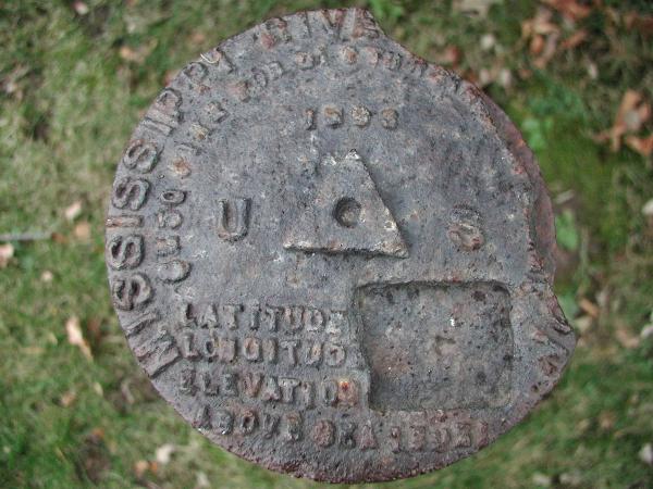
You are welcome Mike, for the photo! I wish I could have found more MRC monuments. How are things, I have been very busy and have not made it into the forums lately.
Kurt
-
Unless I can find a section corner on publicly accessible land that actually has something there, I won't actually be seeing what is inside those monument boxes. And I don't know if PLSS section corners that aren't at a road would have anything there. (The monument boxes I have seen in the road all seem to correspond to PLSS section corners, I haven't seen any others. Though I could have missed some, they're not always easy to see.
)This thread, and the research I've done as a result of it, has incidentally cleared up a little mystery about where the name "Baseline road" came from. And kinda makes me want to try to arrange a visit to Meridian-Baseline Historical State Park.
When you go you should find the Michigan Meridian. Looks like it is in the woods. Check this website:
http://www.pmproject.org/MIPM.htm
The coordinates I have for that is:
42°25'28.00"N
84°21'53.00"W
If you get better coordinates please share them here.
Thanks
Hey I've been there! I have been busy and away from the posts for awhile and missing these good conversations.
Kurt
-
I have a photo but can not figure out how to upload it. I do not get the icon box that the help section shows.
The coordinates are
N 38 deg 52.808 min
W 077 deg 02.416 min
Looking at a map they seem to be closer to
N 38 deg 52.799 min
W 077 deg 02.409 min
It is on the Tidal Basin bridge and the disc reads
U.S. COAST & GEODETIC SURVEY TRIANGULATION STATION
FOR INFORMATION WRITE TO THE DIRECTOR WASHINGTON D.C.
$250 FINE OR IMPRISONMENT FOR DISTURBING THIS MARK
TRAVERSE STATION GATE 2 1970
In the center of the disc is a triangle with a dot in the middle.
You found PID HV2004
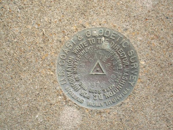
Kurt
-
southpawaz, NGS Surveyor and Z15,
Thank your for the helpful information. I think I now have the Highway Station figured out. It all fits nicely with what we saw at PA0350.
Regarding George’s definitions for the Survey Station, it appears that definition 4 or 5 would apply in the case of PA0473 and we must be looking for some kind of unknown monument. However, it is a bit puzzling that the 1903 description for PA0473 mentions the “Central Oregon Highway (U.S 20)”. I would think that 1903 was too early for a “highway”. It is as if someone from a later time added information to the 1903 description.
As always - Thank You for the education, gentlemen.
TillaMurphs,
If you are using the USGS Leveling book, then at the beginning of the section for that particular bench mark, there should be a lead in section which shows which quad they were leveling on. You can go to this website and possibly download the correct historic quad: Oregon Historic Quads
These originals are very helpful to see where the roads, junctions and various features were compared to now. You can take the image and reference it onto google earth and usually get yourself in the correct area. If you find the quad from around 1900, it will clearly show the BM X positions for the leveling book bench marks.
Kurt
-
I was just looking at the Center of Population thread, and got diverted to checking out the OPUS DB datasheets.
This got me wondering if there is (or will be) a way to file recoveries.
I realize most of these marks are too new to need 'verification of continued existence' as yet...
AZ,
If you are talking about making recoveries through the OPUS DB site; you have to be submitting dual frequency survey measurements to use this avenue. Here is one of my recoveries from National Surveyor's Week: OPUS DB Recovery
Kurt
-
If anyone missed the first episode of the series, it's replaying again tonite at 7 Central time
or you can see it online here:
LSU,
For those of us without cable; thanks for the heads up and link!
Kurt


Geographic Centers
in Benchmarking
Posted
Jerry Penry has been working on this subject:
http://www.penryfamily.com/geographicalcenters/main.html