


Bite_Me
-
Posts
22 -
Joined
-
Last visited
Posts posted by Bite_Me
-
-
Yesterday I decided to update my six year old City Navigator V8 maps. Brought the lifetime maps update from Garmin and was able to download the maps onto my Windows 7 desktop computer and was able install the new maps onto my 60CSx. The download process put the new maps under the "City Navigator North America NT 2013.40.gmap" directory. I would like to copy these maps to my laptop computer. So I copied over the maps, keeping the same directory structure. I exported the registry keys under "HKEY_CURRENT_USER | Software | Garmin" and "HKEY_LOCAL_MACHINE | SOFTWARE | Garmin" from my desktop and imported all the keys to the laptop. No joy. Starting MapSource 6.5.11 on the laptop does not show the new maps. MapSource does show them on the desktop. The download process took 4+ hours on my slow 1.5Mbps internet service. So I prefer not to go through that again. Is there a way to copy City Navigator "Update" maps to a second computer?
-
Some people in the USA government is thinking of equipping every car and truck with a GPS to track the miles we drive and tax us on those miles. The following quote is taken from the middle of the Associated Press article and the link is given below.
"While details have not been worked out, such a system would mean equipping every car and truck with a device that uses global positioning satellites and transponders to record how many miles the vehicle has been driven, and perhaps the type of roads and time of day."
-
I played around with the font size in 6.14.1, because some of the MapSource text shrunk and is rather hard to read, like the blue text for POI's got smaller. After messing with the font size I noticed the text on my waypoints no longer were displayed. I tried all the options but no waypoint text. So I decided to reinstall 6.13.7 without uninstall 6.14.1 first. This went fine, but I still get the 6.14.1 multicolor/larger icons?? So I then uninstalled 6.13.7. Thus no MapSource on my computer, and then reinstall 6.13.7. Now I still see the 6.14.1 icons. I don't have a problem looking at the new icons but if anyone knows how I can go back to the 6.13.7 icons please tell me, in case I want to have a complete 6.13.7 system.
-
Thanks for the RAM mount suggestion. RAM mounts seems to also use a plastic cradle under tension. So I think I will pass.
-
2) The road closed, or re-navigation feature is REALLY cool, but can also be REALLY wrong as well. I was using it for a business trip in Canada last month and there was a bridge out, every time I would change directions and drive 5 miles away it would recalculate and send me right back the same bridge. Now I relies that this is a feature and not really an error by the GPSr but it is something I think you should be aware of.
When encountering "closed roads" you can try a different routing method, like routing for a "bicycle" will avoid major roads and often give you a completely different route.
You can also route without following the road. Of course this just gives you just a straight line to your destination, which can tell you if you are at least going in the right direction.
-
As you can see the cradle for mounting my 60csx onto my bicycle handlebars snapped. I was crossing a cattleguard at 18 mph when it gave away. Due to the tension in the cradle it launched my receiver forward so I had a great view of it bouncing and sliding along the asphalt road. Except for some nicks and scratches it still works, and lucky for me the screen didn't receive any scratches. I brought the handlebar mount from REI so I plan to get my money back, and NOT get a replacement. As I will not take the risk of mounting my receiver onto my handlebars again.

-
Garmin's MapSource 6.13.4 just popped up this "Map Update Notice". Is there some registry hack I can deploy so MapSource will never again pop up this window. If not, how often is MapSource going to remind me? I really hate software that pops up these update notices.

-
Hey rwsmith123 thanks for sharing. It worked for me. The process did blow up on the largest map segment, because my computer ran out of memory space. I would suggest anyone attempting this process make sure their RAM plus paging file be at least 1.5 Gbytes, and not have a lot of other open apps.
-
No, it is Garmins fault. Garmin is losing distance not due to accuracy but due to dropped distance. If you go 1 mile, the track you save (by going to tracks, and selecting save) accurately states 1 mile. The problem is the "Odometer" will say you have only gone something like 0.9 miles. if you are going slow. This is not a sattelite accuracy issue but a software bug.
I don't think its a software bug. I believe the code is running as intended. Here is a story I posted on this problem a while ago. I think it describes the tradeoffs Garmin has to deal with.
I recently did a hike that started with a 20% or higher grade. I reset my 60csx and immediately started hiking. I'm going rather slow, <1 mph, up this steep grade. After half an hour I stop for a drink. The trip computer showed I as moving for 10 minutes and was stopped for 20 minutes. The funny thing is my legs and lungs were telling me I was moving for the whole half hour. So my trip computer recorded only 33% of the time I was on the move. Later on this hike near the summit I came upon a couple and they asked me "how much further to the top?" So I grabbed my gps, went to the track screen, saved the entire track, brought up the saved track to see how far we were from the trailhead. Since I knew how long the hike was I was able to answer their question. It's too bad, but the trip computer is not as accurate as the track log when hiking at "slow" speeds. The trip computer is much better when hiking back down hill at higher speeds.
It seems to me when you are moving at a slow speed this movement is considered by the gps as drift, the movement you see on your screen when in fact you are stationary. So Garmin has to determine what movement is drift and leave it out of the trip computer and what movement it should include into the trip computer. Perhaps add an option where "all" movement is added to the trip computer and thus there would be no stoppage time and when a person is stationary the gps drift is added to the trip computer. So the trip computer would error on the high side versus the track log. What I would like is an option where the trip computer simply shows the length of the active track log.
-
Never saw any response by someone who actually used your code and instructions to create these larger segmented Topo maps that could all be downloaded onto a 2GB card and used in the GPSr. I used your routine last week and it worked like a champ. When looking around for a way to solve this problem, I found your post and this one:
http://www.groupsrv.com/science/post-2197256.html
I tried both approaches out a little over a week ago. Running at the same time, it took about 48 hours for them both to complete. The other method mentioned above "seemed" to complete OK, but when I checked out the map segments in the GPSr, many of them were not available and I think this is probably due to the GPSr addressable map segment limit. However, with your methodology, I have the whole Topo US map set available in my GPSr. Thanks a bunch for making this available. It worked great for me.
Russ
How much memory space does the whole Topo US map set take?
-
I recently did a hike that started with a 20% or higher grade. I reset my 60csx and immediately started hiking. I'm going rather slow, <1 mph, up this steep grade. After half an hour I stop for a drink. The trip computer showed I as moving for 10 minutes and was stopped for 20 minutes. The funny thing is my legs and lungs were telling me I was moving for the whole half hour. So my trip computer recorded only 33% of the time I was on the move. Later on this hike near the summit I came upon a couple and they asked me "how much further to the top?" So I grabbed my gps, went to the track screen, saved the entire track, brought up the saved track to see how far we were from the trailhead. Since I knew how long the hike was I was able to answer their question. It's too bad, but the trip computer is not as accurate as the track log when hiking at "slow" speeds. The trip computer is much better when hiking back down hill at higher speeds.
It seems to me when you are moving at a slow speed this movement is considered by the gps as drift, the movement you see on your screen when in fact you are stationary. So Garmin has to determine what movement is drift and leave it out of the trip computer and what movement it should include into the trip computer. Perhaps add an option where "all" movement is added to the trip computer and thus there would be no stoppage time and when a person is stationary the gps drift is added to the trip computer. So the trip computer would error on the high side versus the track log. What I would like is an option where the trip computer simply shows the length of the active track log.
-
EraSeek, you are correct. It is the one high up on Mount Saint Helens. I was wondering if someone would recognize the mountain in the background and figure out where my photo was taken.
TopangaHiker, it doesn't come with a car charger, but something better. An array of solar cells to give it power. You can see the array in EraSeek's photo on the right edge. I don't know where you can place an order for one, you will have to find that out yourself.
-
If you don't think your current GPS receiver is accurate enough, than perhaps you should get one of these.


-
To see if I can add an image.

Does it work.
-
Direct uploads are not supported but
you can host it at a "free" web hosting site first, like imageshack.us or photobucket.com.
PS: Or archived/unpublished caches can work as well...
Edited: For more expansion of solution(s)
OK, thanks for the info.
-
How does one add images into a posting? When I click on the "Insert Image" icon it asks me to enter an URL address for the image. The image is not at some website, its on my disk drive.
-
I sent my hiking story to Garmin support and here is their response.
"Yes, there has been a noted issue with the Tack Log and Trip odometer
giving different readings. The engineers are aware of it and currently
working on a resolution. I believe my supervisor may already have a "Beta"
update that I can send you, if you wish to try that. Otherwise I will ask
you to wait until the next software update is released which should
address this problem."
So hopefully we slow-poke hikers will soon have a more accurate and dependable
60csx odometer.
A second strenuous hike I did confirmed the same odometer problem as the hike
I related to Garmin support. Slowly hiking up a steep grade produces a low
odometer reading versus the tracklog.
I got a brand new 60csx and found this very problem on my first hike with the unit. The hike was an up and back hike, so the distance travelled should be the same for the up and down legs.
Up the mountain leg:
Odo = 3.76 miles
Track log = 4.6 miles
Whole hike (Up leg plus down leg):
Odo = 8.33 miles
Track log = 9.2 miles
A little subtraction gives us the Down leg:
Odo = 8.33 - 3.76 = 4.57 miles
Track log = 9.2 - 4.6 = 4.6 miles
This is a somewhat streneous hike with 3850 feet of elevation gain.
So why is the odometer reading so much lower going up the mountain then it is going down? It's the same trail going up or down, so forest cover is the same. The main difference between the up hill leg versus the downhill leg is my speed. We took 4 hours (including breaks) going up, and 3 hours (including breaks) going down. Is there a minimum speed you need to be going before the odometer kicks in? According to the altitude profile, during the steep upper portion of the mountain we hike from the 7000 ft to 9500 ft in 1.64 miles. Gaining 2500 ft in 1.64 miles means we were going pretty slow. According to the track log this steep section took 2.5 hours (including breaks) to travel the 1.64 miles.
I find this problem rather surprising. My crappy old yellow etrex (version 2.14) GPS odometer is more accurate on a streneous hike then this new fancy 60csx unit.
-
The altitude reading is important to me can best be explained how I currently use my current crappy yellow etrex GPS on a hike, which is my main usage for a GPS. I leave it on the display showing my current altitude so I know how much more I have to climb to get to the destination, usually a summit. How much more I need to climb is more important to me then how much further I have to go.
Why do you say the barometer reading is more accurate versus the GPS reading? To get the most accurate waypoint reading, it seems you use this "averaging" function where the altitude is selected using the GPS alitmeter, not the barometer altimeter.
Automatic calibration is a bit of a strange thing, since the the GPS readings used for the calibration are usually less accurate than the barometer readings! I guess this means that in auto-calibration mode the instrument does a lot of averaging over time to minimize the effects of GPS errors, and only re-sets the barometer when there has been a significant difference between barometer calculated altitude and GPS elevation more than a certain time. If the auto-calibration sets the barometer too often, you will lose the benefits of the accuracy of the barometric altimeter.
The point is this: the barometer has no way of knowing your actual altitude, but it can measure very accurately a change in altitude. So the best thing is only to use auto-calibration if you have no better information. If you happen to know your correct altitude (because it's marked on the map, for instance), calibrate the altimeter to this altitude.
I just re-calibrate the altimeter when I get the chance: it's usually not far from the truth and the re-calibration only takes a few seconds once you've got used to it.
To help you in your decision, maybe we need to know more about why accurate altitude information is important for you. And don't forget the other difference: the compass. Some people love it, others couldn't care less.
-
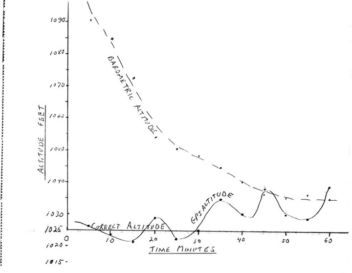
Doing more research I downloaded the 60cx and 60csx manuals. The 60csx manual says this unit will self calibrate the barometric altimeter each time you turn it on. I thought this was cool, because accurate altitude readings are important to me. Then I found the following review of the barometric altimeter and electronic compass for the 76s unit. The 76s "probably" have the same sensors as the newer 60csx unit. The review said the barometric calibration can take an hour! Yikes. Here is the link to the review and a link to the JPEG graphic showing the long calibration time.
http://www.gpsinformation.net/waas/g76s/g76s-map.html
http://www.gpsinformation.net/waas/g76s/baro-plot-r.jpg
Do you 60csx or 76csx owners find it takes a while for the altitude reading to stabilize?
Any more comments would be appreciated as I'm still on the fence between the two units.
Thanks,
-
I'm looking for a new GPS and I'm trying to decide between the Garmin 60csx and 60cx handhelds. I was wondering why the 60csx has two ways of determining the altitude?? By way of locking unto 4 or more satellites or using the barometric pressure. I would think the GPS altimeter would be more accurate than the barometric altimeter, given the fact air pressure is constantly changing. So what is the advantage of including a barometric altimeter into a GPS? Those who own the 60csx or 76csx units do you find the altitude readings from the GPS altimeter are always close to the readings from the barometric altimeter?
Thanks,
Copy City Nav Update to another computer
in GPS technology and devices
Posted
Worked GREAT! Mucho thanks!