


Stefanoodle
-
Posts
50 -
Joined
-
Last visited
Posts posted by Stefanoodle
-
-
A fine achievement. Onward and upward. Here's wishing you well on your next century.
-
This is a really brilliant, yet simple, idea. I think I will get going on that too.
Just be careful if taking children CITO caching, then some latex gloves really would be applicable.I didn't know children were THAT toxic!! I thought that was a myth perpetuated by the owner of the scream factory in "Monsters INC."

-
I don't know whether what I say will really answer your question, though you seem to have pointed out something valid: generally, the unit either works, or it doesn't, as you mentioned about the binary states.
Quite a while back I had one day where all my values were off by about 150 metres, which is a huge error. I also thought it might be the unit, and that it might need calibration. Two electrical engineering colleagues (who have in the past been involved with building some form of GPS units) I consulted, told me what you have said: there is no calibration; either it works, or it will give you nothing. Since I'm a mechanical engineer, I have less insight into the electronics and programming, so I will take that at face value.
What I have discovered, and it's been mentioned in various places in the forums, satellite geometry is probably most influential on the position you get. If I have only three satellites, then my error is much greater than when I have five or six or more. Also, the closer I get to a cache, the more variability I get, so sometimes the position does seem to take me in circles. That's why I use a compass, and triangulate from a bit further out. After all, I have an antique Magellan Trailblazer XL from the last century!!
So, some days I have spot-on results, and other days I also don't get great results. Check for number of satellites you are picking up, whether there is poor satellite geometry (e.g. they all are in a line, etc.) or just poor reception because you are under some trees. And then the final mystery on my unit: if the batteries are running down, I also get worse results. I would like to ascribe this to the number-crunching going on in the unit, and if the power is dropping, perhaps the algorithms are not being run as quickly, hence the slower response and jumpy results. Then again, if there is a voltage control in the unit, perhaps my reasoning is faulty. Could be a chance thing.
Happy caching
-
Sad news is that Escaped from Boston TB is NOT in Sentinal View cache. Perhaps someone forgot to log taking the TB?
-
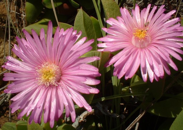
There is always more to be discovered when out caching, apart from locating the cache itself. These pretty vygies were in bloom all over Table Mountain along the Pipe Track. They relate to the Oudekraal April Fool cache, which was a wonderful way to spend a Friday afternoon while others were slaving away over a hot computer.
Just an aside on the photos which have already been submitted: when posting them to the cache page, they have to be less than 125kB and smaller than 600 pixels. This does reduce the image quality, and it would be a shame for people's photos to suffer this fate. Should we submit them to geocacher.co.za in their full glory too? I might have missed this bit, so flame me if you will.
-
Quite a hot topic ...
I'd also be in favour of increasing slightly the value of placing a cache over the value of finding one. Cachers should be encouraged to grow the sport. Just don't make things too complicated to administer. I really liked the suggestion of the Duckworth - Lewis system
 . We don't want to go to that extreme. The current ranking system is great already. Too much tweaking and soon there will be several competing rankings running in parallel, all with different criteria. After that, a ranking system probably becomes meaningless.
As pointed out, if someone places a dud owing to inexperience, it will pretty soon become evident. If it's a real problem it will eventually be archived. But more experience doesn't necessarily equate to better placements although one would expect it to.
And finally, just to throw a spanner in the works (I have a full-time position as Devil's Advocate
), how many of the currently active geocachers actually read the forums? So a lot of the debating about finding X number of caches, rankings, etc. doesn't necessarily filter through to all players, whether veterans or noobs. I seem to recall that it took me quite a long time before I actually ventured into the area called Forums, mainly because I'm not a chat-type of person, and thought it would be much of the same thing (clearly, it isn't, but perceptions can run deep).Anyway, have a great caching weekend ...
-
Great webpage -- nice work. It will be interesting to see what the rankings are like once you have added more cachers.
I would think the weather where you are is about as miserable as it has been here in Cape Town, so you spent the time in front of the computer instead of out caching. I think Discombob is about the only Capetonian who braves the rain, thumb injuries and fainting spells to enjoy the great outdoors.

I don't quite agree with Discombob about the locationless caches being less worthy than "real" caches, though. Some of them, sure, they could be a bit lame, but what about those that require a longish trip to find, and which are not all that common? How many pontoons around where you stay? Or tractors with steel tyres? Beach huts easy for anybody close to the coast, but not all beaches have them. Did you know there was a carillon (the only one in Africa) right here in Cape Town?
Just my 1 cent's (adjusted for inflation and forex fluctuations) worth
-
It looks fascinating, though I have not tried it. I don't think my system here will handle it yet, in terms of hardware, but I would have the necessary connection speed. Let us know what it's like when you have it up and running.
-
Remember I'm a poor bloke so it will not be a top of the range model! Maybe one that still works on steam
Hey, now that might be an improvement on my Magellan Trailblazer XT (traditional weapon type), which I'm sure works on paraffin as follows:
The pilot light from the paraffin heats up the area under a small treadmill. This motivates the hamster in the treadmill to start running, which then generates enough energy to power up the unit (remember to raise the antenna if you want satellite reception). I have not figured out what the three batteries do, but they don't last much longer than about four hours continuous anyway, and generally die just when I'm about 300 metres from a cache.

-
Brilliant idea. These SA Geocoins are really beautiful if the image is anything to go by. I found a US Geocoin the other day, and was quite impressed, but I think the SA one looks even better. Great design.
Please put me down for two (2) coins.
thanks
Stefanoodle
-
Is the Clarke 1880 the same as the Cape co-ordinate system? I seem to recall Cape is referenced to Clarke. If so, your GPSr may be able to convert for you if you set the datum as Cape. My GPS unit has that datum.
I think programmes like OziExplorer may also have Clarke 1880 as a possible datum. If I find out more, I will post here.
Alternatively, you could contact the Department of Land Affairs, Chief Directorate of Survey and Mapping, in Mowbray. They have a website http://w3sli.wcape.gov.za too.
This might be quite useful too: http://w3sli.wcape.gov.za/Surveys/Mapping/wgs84.htm
They do have software to convert between Gauss conform, WGS84 and Bessel. I don't recall whether or not it also could work from/to Clarke.
good luck
-
I never knew that about cracks in rocks. It's pretty neat.
Here in southern Africa one can also find a general direction by looking at tall termite mounds built by the species natalensis (so said the game ranger). They generally are orientated to point NW. It supposedly has to do with the temperature regulation in the nest. My experience in the bush tends confirm the NW orientation.
Similarly, the same game ranger who had been a military scout indicated that a particular bird, the buffalo weaver, also builds its nest on the NW side of a tree. Again, it is supposed to have something to do with temperature regulation for the eggs. Now all one has to do is become a birder to know which bird to recognise so as to know which way one is facing.
There are a lot of other ways to get a basic bearing when one is without a compass, but I guess you probably know that.
-
Hi Alex,
perhaps there is one in Namibia, which used to be a German colony (Deutsch Südwestafrika). There are many interesting historical buildings all over the country.
The other previously German colony is Tanzania. I don't recall seeing a tower; there were many beautiful cathedrals and mission stations, though.
good luck with your search
Stefanoodle
-
I fully agree that the owner should take note and investige/do maintenance. There could be the problem that a cacher might not have looked properly, but there are definitely listed caches which have been raided (debris found, destroyed by fire, etc.), and they are not being archived, replaced or maintained. Same goes for reports of waterlogged or otherwise damaged caches.
I'm probably guilty of not always contacting the owner when I suspect a real problem. I have made contact before, and in one case there was no response, in the other there was confirmation that the cache could be MIA, but still it was not archived. So I think I have also just crossed it off my list, but of course, this doesn't help the next person going to look for it.
There is the option to recommend a cache for archiving when you go to log it, but I think it would be rude to do so before contacting the owner first.
-
Sounds like a brilliant idea. I would love to hunt a multi like that. Here in South Africa someone has done an historical multi. I have learned a lot about the sites, and find the theme fascinating.
WindChill's idea of using something on the building as part of the next co-ordinate sounds like an excellent idea.
All the best for your cache.
-
Hey Tony,
I'm sure the camo containers will be good here. There isn't really a standard in South Africa, but opaque tupperware-type containers are very popular, as are 2 litre ice cream containers (white, or painted).
The modus operandi here is more along the lines of hiding a container in a very traditional way: under some rocks, in a crevasse, on a ledge. Usually, the caches are in pretty places, close to a path to avoid bashing through thickets and damaging the area.
I have not yet seen a cache in the open, but cleverly disguised; the Americans seem to do that quite often. Some of their caches look like a rock, or have bark glued to them, and are left out in plain sight (according to the posts on the forums). Urban caches (micro or otherwise) are also not yet popular here; not sure why not, though.
There are a few caches near the Hartebeespoort Dam. Most of our caches are not difficult to find, but may have a medium to high terrain rating because they involve a bit of a walk.
I like your stats on the cache to population density; very interesting indeed to see how high NZ rates. Geocaching is still a growing sport here, probably slowed by the cost of GPS receivers. But it's encouraging to see new players appear all the time.
Enjoy hiding your cache when you get to South Africa, and have fun finding some of our caches.
-
I agree with all the other posts. I have a Magellan Trailblazer XL, which is also an antique. It only offers two decimal places, but the third decimal place is approximately 10 metres (about 30'). I have had absolutely no problems geocaching in terms of accuracy: determine from the third decimal more or less how many feet you need to move E/W or N/S once you reach the destination. Besides, between 20' and 30' is about the average accuracy I get anyway.
If you have the option, switch to UTM. That shows you the location in metres, which theoretically could bring you closer than two decimals, but given the overall accuracy, it's not a huge difference. I generally use UTM when searching.
The only three drawbacks I can think of with my older model of GPSr: it needs three AA batteries, instead of two, it depletes regular alkaline batteries in about five hours continuous use, and it is larger and heavier than many of the new models.
But as far as its ability to point me towards the cache, I have no disappointing stories to tell.
Good luck
-
Jors,
they were not too specific on the size of files, but mentioned that they varied between 6Mb and 12Mb. There are a variety of formats that you can choose. These were listed on the site, and there is no cost for that. If, however, you would like something like jpg, then they would probably charge for the conversion as it is not something they do on a regular basis. I was not sure whether I should go for tif or dxf. Either can be opened with PaintShop and converted to something else, if necessary.
Based on the scanning I tried in the past, I have managed to get a 1:50000 map down to between 8Mb and 15Mb, usually in png format. This is larger than they will be in jpg, but remember that jpg is compressed. As soon as you open a jpg with any application, it gets rather large and chews up resources on your PC. Then your applications slow down. So someone recommended using png (portable network graphic) which is not as resource-intensive.
From what they were telling me, the entire range of 1:50000 in tif would take up approximately 44 discs. The dxf format was smaller and would require between 20 and 30 discs. I just hope I didn't make the wrong decision going for dxf in order to save a few discs. Anybody have any suggestions what format would be best to start from?
Sorry, I don't know more about the orthophotos, but from the website it looks like they are also for free.
They have always been extremely helpful, so I'm sure they will be able to advise you accordingly.
Oh, and a spindle is just a way of buying discs in bulk. They come in something called a "cake box" 'cos it looks like a small cake tin, and the discs are stacked on a plastic rod or spindle. It does mean that you generally have to store the discs together, as they don't have the regular jewel case, but these can also be bought separately at about R2.50 each.
-
Jors, you are absolutely right. It has been a while since I last checked with Mapping and Survey. The price of printed maps is also about half what it was last year.
I went to Mapping and Survey this afternoon and ordered a complete set of digital 1:50000 maps of SA. You can even take your own discs, so there is no cost (unless you take a spindle; in that case you have to pay for jewel cases because they include a licence agreement and copyright notice). The only downside at the moment is that they have quite a backlog, and they said the order would take about 3 months. Patience is a virtue, so I'll wait.
-
Here is a site that offers maps of South Africa. It looks like they are from the 1:50000 range. You can save the images as jpg files, which can then be imported into a package like OziExplorer. Although the maps are less than 5km across at a useful resolution (zoom), I guess you can patch a few jpg images together to produce a larger area.
South African Geographical Names System
Obtaining digital maps is very expensive (even though Mapping and Survey state that they are a "by-product" of the map making). I have scanned some paper maps (this is presumably a violation of copyright, even though I have bought the originals), but large scanners that can handle A0 sizes are few and far between, found either in an architect's firm, or at a university. And the scanning service will also set you back a few bob.
-
I'm not familiar with the Magellan 310; I have a Trailblazer XL, which is ancient. It also has a two-digit decimal display. So when approaching a cache the closest it gives me is in units of 10 metres (about 35 feet). However, I now usually use UTM to indicate my position (and enter the cache co-ordinates). This display is in metres, and I can usually find the cache more easily than using the count-down when I'm close.
As mentioned by others in various threads, satellite geometry and the number of satellites you are picking up can greatly affect the success of your hunt.
-
Generally, it's probably a case-by-case situation, as others have noted. Some people might not like anybody to mess with their cache, others would welcome a helping hand.
I found a cache which was totally soaked. Even items in double ziploc bags were wet. The first person who found the cache already made mention of this fact, and all subsequent geocachers make a note of it; it's almost a year later, and the cache still has not been sorted out by the owner.
I dried everything as best I could, including the log book. I wouldn't remove a log book, but would put a new dry one into the cache if I had one on hand, and mention this in the new log book. I also sent an eMail to the owner, but there has been no response, although I know he is active.
If I would have had a spare container (unlikely thing to carry around when I'm geocaching) I would have replaced the leaking container and notified the owner, but ultimately, I believe the owner is responsible for maintenance.
-
I understand your feeling of puzzlement; I have on occasion had similar experiences. I have a Magellan Trailblazer XL, which is pretty ancient. On one weekend I found two caches, but mainly because I had a good idea where to look (and they were virtual caches), but my readings were between 90 metres and 150 metres off. One of the caches was actually a calibration point erected by the Department for Surveying and Mapping.
I spoke to two friends (electrical engineers) who have at one time or another been involved with building GPS units commercially. Some of the issues are:
* buildings or mountains do NOT reflect the satellite signal (RF signal) because it's much too weak (- 130 dB) to reflect.
* poor satellite geometry, i.e. when they are all in a straight line, certainly will cause poor position calculations
* GPSr don't need to be calibrated if they are not reading correctly; if the calibration is out, they will not pick up satellites AT ALL.
* perhaps SA had been turned on temporarily (in light of the possible Iraq war), but there have been no internet postings to this effect, and the problem was only occasional.
This didn't really solve my problem either, but it did exclude some reasons I had thought of. What I have done in the meantime is keep a log of the GPSr's positioning as follows:
* choose a place where you can get repeated records (I sit in my garden in the same place)
* take say 20 readings, one every minute or 30 seconds.
* take a note of the satellite geometry and how many satellites you are locked onto
* plot the readings (I use Excel and plot UTM readings)
* repeat over several days or weeks
There is also some Shareware called VisualGPS which plots real time readings or logged data specifically for this purpose. I have looked at it, but have not tried it yet.
What I have discovered about the accuracy of my unit:
* satellite geometry has a huge effect
* the number of satellites also makes a difference, i.e. only three satellites has more drift than say 6.
I'm sure we all have days when our readings are not good, or drift quite a bit.
-
I agree with the reasoning above. I also did the maths once, as I have a Magellan Trailblazer XL which also has a 2 decimal point readout. At first I tried between deg.min.sec vs. deg. decimal min, but that didn't help as far as a more accurate readout was concerened. Now I use UTM most of the time, especially for inputting the co-ordinates of the cache (you don't introduce rounding errors like that). That way, when there are no distinct landmarks when I'm close to a cache I can take a reading and then know that I must move a certain number of metres north or south, east or west to find the cache. And considering the Trailblazer is such an old instrument, I'm constantly being surprised by the accuracy and the success rate of this method.
 . We don't want to go to that extreme. The current ranking system is great already. Too much tweaking and soon there will be several competing rankings running in parallel, all with different criteria. After that, a ranking system probably becomes meaningless.
Milestones
in South Africa
Posted
Great going, TV&M on your triple century, and GlobalRat on your double century. What remarkable and enthusiastic cachers. May there always be yet another cache to hunt down.
best wishes and happy caching
Stefanoodle