


monkeykat
-
Posts
194 -
Joined
-
Last visited
Posts posted by monkeykat
-
-
For a few months now I've been noticing that when I upload photos to a log or a travel bug, they sometimes show up with the correct month and day, but the year is 2006 instead of 2007. Has anyone else seen this occur? I've been trying to narrow down just when this occurs, but it seems to be happening very randomly.
Last night I uploaded 33 pictures and 6 were the correct date and 27 were wrong. Of the 27 wrong ones, all were on Travel Bug Galleries. Of the 6 correct ones, 5 were on Cache logs, and one was a travel bug.
First I thought it was happening when you go back and add an image to a log after it is submitted. Then I thought it was happening only for travel bug photos. But lately I have had photos correctly dated for both of those cases. If you check my profile, you will see that I have images in my gallery that are dated from before I even created an account on Geocaching.com.
When uploading an image, there is no place to set the date of that image, so it should use the log date I would assume. Its a little annoying to not have a chronological order of photos in my gallery, but it is also goofing up other people's travel bug galleries as my pictures show up earlier than other peoples images.
Its not a big deal, but I would be curious to see what is causing it.
-
If a mark has been recovered within the last 10 years I usually don't report it unless there has been a significant change, or something to make note of. So that would take me out of the immediately revisiting category. Is this considered too long a wait period?
-
 August 13 by NumbersHound? (1013 found)
The owner of the cache has allowed me to log this as a find even though it is MIA. I am coming through before the owner is able to replace the cache as he is vacationing. Thank you CACHEOWNER
July 21 by HonestCacher5 (1604 found)Yep, this one is definately MIA. I stopped by on my way back form Geneva with Bingo Kim tonight and the cache is no where around in the spot I found it last year.
MickEMT
 July 10 by HonestCacher4 (49 found)
No luck from this hea trifocaled ole boy from Souff Cakalina.
Muggled? My boy wiff the Eagle eyes couldn't find it eiffer.
July 9 by HonestCacher3 (176 found)Looked for a while, but no luck. Seemed obvious where it should be...
June 27 by HonestCacher2 (40 found)Oh well, seems to have disappeared.
 June 24 by HonestCacher (722 found)
?Muggled
-
I've been waiting until close to the end of the month, and then submitting my recoveries that are worth reporting to the NGS. I noticed that a few that I am pretty sure I submitted in May, June, and July have not shown up on the datasheet from the NGS, but others that I submitted after or around the same time did. How long should I wait before submitting them again? Is there a database catchup time? I don't think any of my July recoveries show up on the datasheets yet (I'd probably give them another month).
-
BDT, I thought a lot about what you said, being a paperless cacher now. I think you are right, probably a good idea to have a copy of each maybe. With condensed versions of NGS Datasheets on a palm, there is really nothing legitimate looking about it. But I am a firm believer that a positive attitude and honesty will get you through any visits from the authorities.
-
awesome, and some bonus photos for the picture thread too!
-
I don't have as many submissions as others, but I keep mine as simple as possible. For mine I would mark recovery as good, and in the description write:
"CANADA AVENUE NOW RENAMED LAKE FOREST DRIVE"
that's it
-
I've looked around some, and I can't find anyone else mentioning this problem, but here it is:
Sometimes when I upload images, the images are given todays month and date, but the year is 2006. It seems like this occurs for Travel Bug Images, and sometimes it occurs when I am posting a note for bugs. There is nowhere for me to set the date when I am uploading images, so I can't figure out how this is happening.
If you view my gallery, you will see on page 10, that there are images I took just this past weekend that appear from last year. There are also images in the gallery dated from before I even became a member here.
It would have been nice for all my images to be chronological in my gallery.
-
Seems complex, but I will give it a shot. I really enjoy just finding the marks, not necessarily trying to find weird combinations of them. But I should be able to get 1 or 2 points I figure.
-
I can speak a little to this topic. The benchmark viewer I developed uses the archived shape files that have been generated by the NGS. They are available from their web site, and you can get a whole state as a zip file. When I first got the shape files, back in April of this year, they had last been generated in March 2007, so I thought that the archived files would be updated quite regularly. I expected to upload a new shape file for each state every month or two, and users would get instant gratification as they could watch their discoveries go from white/red to green in the area. Now it is almost 5 months later and the shapefiles haven't been updated, so unfortunately there won't be instant gratification. Its looking like the viewer will be a more recent snapshot of the NGS database, but not as dynamic as I had hoped. I plan on getting this information into my FAQ soon.
The previous thread link probably states this, but the original poster has probably found a mark that was put into the database after the Groundspeak snapshot, and before I took my drop from the database.
As for new ScaredyCat Benchmark viewer updates, I am working on a script to generate .LOC files from the PIDs you select, so it can be more of a 1 stop location for benchmark hunting. I have gotten tired of looking for marks to find on the viewer, and having to write them down and go to another application or geocaching.com for my LOC files. Hopefully I can get it up some time this week.
-
I use a palm M500, it has a black and white screen, which shows up better in the sun than some color screens, and it is older, which equals Cheap. If you are lucky, you can get a used one off ebay for under $30. It also supports a memory card, and USB. All software is downloadable from the palm website.
-
Well, since rain has thwarted my July 4th Geocaching (I was originally going to go out rain or shine, but then decided I really didn't want to look for a bunch of tricky micros in the heavy rain), I have decided to add a few things to the benchmark viewers.
As a couple users suggested, I have been able to add a toggle button to turn on and off PID Labels from each of the markers. It will only add the label on non cluster markers. Also, it slows things down a little so I suggest leaving the labels off while you search, and then turn them on when you are zoomed into your search area. I have also added the "tool tip" labels that show up over marks, much like when you put your mouse over an image and see the ALT text. These are on all the time.
I also turned back on the scrolling that shows the complete Marker Info window. I had this turned off because the map would always try and refresh when the scroll was completed. Now I have the refresh turned off whenever an info window is open. Hope this works well for everyone.
Added some warnings about not removing markers.
Enjoy.
-
I had a great time finding mark OF2732 - SILL this past weekend, and I thought I would share it with you.
First off, the location is great, On a bluff overlooking Lake Ontario. There is a street with small houses on the south side, and on the north side of the street is a narrow strip of grassy land with maple trees and a perfect area to set some chairs and look out over the beaches. In between the bluff and the beach sits an old railroad bed that was ripped up in the past 20 years, so now it is just a grassy area.
As I approached ground zero with my GPSr and gear, there was an older gentleman mowing his lawn. The description states the disk is 1.5 inches below grade, and I assumed it was covered in grass. The home owner saw my quzical look and stopped his mower to come over and talk. I introduced myself and asked him if he was "Mr. Sill", as the mark stated that it was in the lawn of an Elanor Sill. He chuckled and said no, that Elanor Sill was the former home owner.
I said that I was there looking for a survey marker and he got kinda excited. We went over the description, and I showed him my GPSr. He was very interested in the coordinates for his house, and said he had extrapolated some coords from a topo map and wondered if I would indulge an old helicopter pilot and compare coords with him, which I did. He then welcomed me to probe around his lawn and look for the mark.
At this point his neighbor came out on the porch and shouted out "Hey, you NOAA?". I said no, but that I was looking for the mark. he came over and said he knew where it was, as he lived here and had seen them place it. He took his barefoot toe and wiggled it into the grass about 3 inches away from where my probe struck a hard object. The home owner and myself proceded to tear up his lawn and expose the mark "SILL".
Both neighbors were happy to find the mark and share history of the area and talk a little about Elanor Sill. The one neighbor scolded the other for not telling him he had a survey marker on his property.
It was a great find, and what benchmarking is all about.
I pointed the homeowner to the NGS page, and he seemed computer saavy enough that I bet he can find some marks in the area. We also discussed our common interest in Satellites and Astronomy and it turned out we both had been out looking as the space station had flown by several nights last week.
-
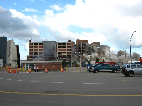
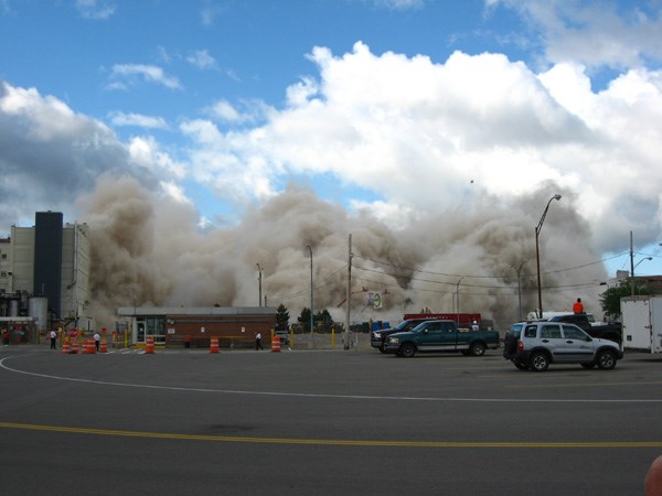
Here are a few photos of the first building they imploded. It was amazing, a huge cloud of dust flew out of the building towards the spectators. Fortunately I remembered my mask.
Before:

Starting:

Getting Dusty:

Really Dusty:

Uh Oh...

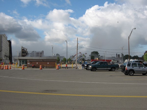
And Gone:

Surprisingly the dust cleared away pretty fast (apprx 10-15 minutes). And cleanup began immediately.
-
Well, both buildings went down in a boom, exactly as planned. The first implosion on Saturday Morning, the building without the benchmarks on it was quite spectacular as a huge cloud of dust made it all the way to the spectators (including me).
The second implosion was a little less spectacular, but still cool none the less. I have uploaded my photos to benchmark page OF2558 - KODAK for you to view them. I was able to do a burst mode of over the several seconds it took for the building to come down. Very loud, and very cool.
I haven't heard back from the Kodak Park Facilities Director as to whether or not they found the marks and removed them or not. My father actually worked/knew the fellow in the past, so maybe he'll let me know the outcome. I'd imagine he's pretty busy right now.
Before:
During:
Dusty:
Done:
-
I wonder if benchmark hunters who "go paperless" bring 1 actual paper datesheet along just for this sort of thing.
I find that I almost feel more official by haing my little PDA with the data sheet information on it. I can stare at the screen and poke at it and people just walk on by.
Whenever I'm out benchmarking, I wear a reflective vest, hardhat, boots and jeans
After 6 months of benchmarking with my hardhat and reflective vest I almost feel naked without them on! I bring them on vacation with me now, just in case I get the itch to search some marks. I feel safer with them on too. In fact, on a Saturday morning, I once dug a hole and tried for 10 minutes to pull up an iron cover in front of a fire station with a Sheriff Officer in the parking lot, and he didn't even question what I was doing. (Unfortunately the cover never came off and I still have to get back with my better tools)
If you pull up there in a 15 year old Toyota sedan...
Sometimes I wish I had a truck for this exact reason. I own a 1995 Toyota Camry, with custom plates, and I think it is the only thing holding me back from looking Uber official. When pressed for what I am doing, tell the truth! Verifying the existance and condition of survey markers. If they press for more info or ask what agency, I tell them none, its my hobby and I do it for fun.
-
I have to say I haven't given papa_bear enough credit in this thread. He has a lot of neat features on his benchmarking pages, and has pushed me in new directions in my development of the scaredycatfilms benchmark viewers. I am glad he posted a link to his site here, as it is well done and very interesting to look at.
Things will cool down a little while development wise on the viewer, as I think they have reached a pretty stable point, and vacation season is approaching for me.
I hope to add some sort of mark labeling like A_Tapeworm suggested, so that you can take the google map with the benchmark markers on it and have a label beneath them. I hope to make it somewhat configurable, so you can turn it on or off, and have it only appear when you are zoomed in relatively closely. That way you won't have hundreds of labels all over and not be able to figure out which is which.
I also want to add some warnings about not removing disks or damaging them, as the recent article in American Surveyor was a real eye opener for me, and I hope that this viewer doesn't encourage people to seek out and destroy the marks.
-
I love the 3 submissions idea!

As an update, I have been able to contact the program manager via email and suggest that they attempt to recover the marks and contact the NGS. He said they are going to try and find out if the disks are still up there (only recovery was the monumenting of the disks in 1925) and see if they can be removed before the demolition. Seems highly likely that the disks would still be there, I don't think they allow too many people up onto the roof at Kodak Park. And at worst, the disks would be destroyed Sunday anyway, so they might as well try and recover them. He said he would let me know their results. (I bet an experienced hunter such as myself could help out
 )
)Hmmm, I have to believe the building has had its roof recovered/replaced in the last 80 years... Hopefully the people that placed the marks put them in a safe location.
Today's forecast calls for afternoon thunderstorms, so I am going to try and get some photos of the buildings tomorrow, before they are destroyed.
-
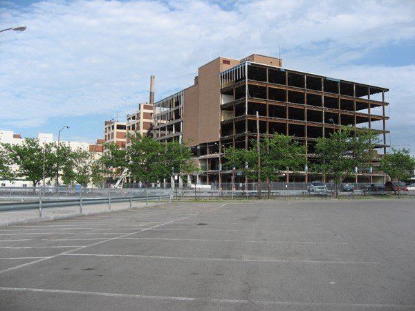
Looks like this weekend, those in the Rochester area who are interested will be able to view the destruction of a benchmark. Eastman Kodak is undergoing a transition from film to digital, and in the Rochester Area, the industrial complex known as Kodak Park has seen dozens of buildings demolished to reduce the company's footprint, pay less taxes, etc...
Benchmark OF2258 - Deisg KODAK sits atop one of the buildings to be demolished, Building 23. The building is scheduled for implosion on Sunday July 1st. A nearby building, no. 9 will be imploded Saturday June 30th.
My father worked in that building for many of the over 30yrs he worked at Kodak. I worked at Kodak for 5 years before the division I was part of was sold. I am very excited about viewing the demolition and will have at least 2 of my cameras there to try and record the implosion. Now it is even more interesting as the building contains the benchmark and reference marks.
I suppose its possible they have been removed prior to demolition. We'll have to check the database over the next few months to see if it is updated.
Article in the local paper: Kodak Park Bldgs 9,23 to be razed
This is going to be awesome!
-
In my opinion, it is totally reasonable to wait as long as a week for the previous owner to log the drop. Of course its best to do the drop ASAP, but sometimes there is no internet access available, or other factors get in the way. It seems like a week is reasonable to me. Of course there is a problem if someone wants to do a quick pickup, and then drop it off soon. Then the TB could end up 2 logs behind! Its all part of the game, but its nice when people are patient and polite. Even an email to the last person to pick up the bug before you do a grab as a last resort is polite.
The idea of not moving bugs when you go on vacation is laughable. I always use vacations to move bugs and coins around for everyone to see.
-
How deep is the water? If one had to make a hasty escape...

I still wouldn't do it, trains are just too big, fast, and powerfull.
-
Another day, and another roll out of the Benchmark Viewer web site. This time I have made a few visible changes, and some behind the scenes. First, the behind the scenes... I have been able to create a State page template so that the only editable regions are the state name, and the major cities. The rest of the page is a template and making one change, changes all 50 states at the same time. This will make updates extremely easy. If I decided to make the map wider, then just change the template, and the change is rolled out to all the other files. Also, I combined my javascript to one file, so again, a change there and it affects all pages.
Now the visible changes. I added Topographic and Orthographic imaging. The ortho is very useful in viewing some areas that may not have detailed google satellite views. The topo is extremely useful, and pretty self explanatory.
I also added Washington DC, as it had its own shape file.
Important: I had to change two files because their two letter abbreviations were reserved words in SQL. For that reason, Indiana, which was IN.html and Oregon which was OR.html can now be found in IND.html and ORE.html. I removed the old OR and IN html files, but tonight I will replace them with a redirect page to the appropriate html page.
Enjoy.
-
Mine also arrived, very cool, and a great reminder of the contest...
I am going through withdrawl though, almost tried to log today's finds on the msg board.

-
Warning!! - Shameless Plug Ahead
I am in development of a web site that displays benchmarks near to you in a Google Maps Application. Simply select your state, and input the zip code/city you live in to view benchmarks in your area. Its kind of a visual representation of doing the nearest benchmarks link on geocaching.com.
http://benchmarks.scaredycatfilms.com/index.html
I'm always looking for new users and input.

 )
)
Uploaded Images Have Wrong Date
in Website
Posted
I checked my camera, it is indeed set to 2006. Interesting that Groundspeak uses the EXIF Data. I am ashamed to say that I didn't even look at that, and I call photgraphy one of my hobbies, and I used to work at Kodak. Ohh well. Thanks for spotting that.