


Jeepster++
-
Posts
271 -
Joined
-
Last visited
Posts posted by Jeepster++
-
-
I guess I'm a little dense because I have tried everything I can think of with the new map and still get no results. With the old map at the bottom of the cache page I would click on the green pointer and it would open the map up to almost full screen and show me the surrounding caches. Now it shows me a cache icon and does nothing when I click it. The only thing I can do is zoom the map in and out but it still doesn't show me any more caches. There was mention of clicking the google maps button. If the reference is to the word google at the bottom left of the map, which is all I see, this will give me a google map of the area but with no caches showing. As I said in my previous post I have tried this with three different browsers. The browser I have always used is SeaMonkey which is supposed to be running on the same engine as Firefox but has mail and newsgroups integrated. It might be helpful if when TPTB make changes it would be good to explain how the changes work.
Use this link for the old map.
-
Can you give me a link to a cache page with this happening?
-Raine
This one has two child waypoints but only shows the one for parking. GC1XXWM
-
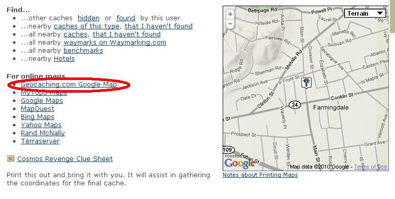
The map on the cache page has changed. For the old map, click on the "Geocaching.com Google Map" to the left of the map on the cache page.
More discussion here http://forums.Groundspeak.com/GC/index.php?showtopic=253500
-
It looks like that map has changed a bit. You can easily zoom in/out, switch from terrain/map/satellite views and I also noticed it includes icons for some of the child waypoints. It's very fast too.
For the old map, click on the "Geocaching.com Google Map" to the left of the map on the cache page.
-
Since this thread seems to be active again -- anyone know what's going on with INATN? It won't come up at all for me, not even the "server overload" screen.
Here yo go... http://forums.Groundspeak.com/GC/index.php?showtopic=253013
-
Owners of iPhones, Blackberry's and other AT&T smartphones may find that geocaching, a fairly data-intensive hobby, especially if you use live maps, could be getting expensive shortly.
I wish I had known that they would do this before I sold my 60CSx and bought an AT&T Blackberry to cache with!

http://www.cio.com/article/595852/AT_T_Dro...s_iPhone_Owners
I was reading about ATT dropping unlimited data plans. I think it's a really bad business plan but with so many people locked into contracts, they can pretty much do what they want.
I just hope other carriers don't follow suit.
Of course if you really look into it you might find that geocaching isn't as data intense as you think.
It is for me! I use my Blackberry for turn-by-turn navigation and mapping, create and download PQs, browse the web for stuff... I really haven't measured it to see how much data I actually consume, but I've felt the unlimited plan to be worthwhile.
Fortunately the Blackberry is more efficient than the iPhone so this may even save me half of what I have been paying for unlimited data.
Login to your AT&T Wireless account and look for the "View Past Data Usage" on the Account Overview page. You'll be shown your usage for the last six months.
-
#44. Alamogul has logged the most finds.
#45. King Boreas has the most hides.
-
-
1. to my knowledge the only software for GPS devices that GC has developed is the one for iPhone
The one for Android is in Beta testing even as I type...

That's good, since Android devices are outselling iPhones now.
That's just in the USA. Worldwide 8,357,000 iPhones were sold phones during Q1 2010 while 5,214,700 Andoid phones were sold during the same period.
http://www.macrumors.com/2010/05/19/gartne...e-manufacturer/
-
It is certainly a way to maximize the damage that can be done to an area. I would not consider it ethical, it certainly is devious. If they are doing it to up the difficulty level then they don't understand. If they do it on more than one cache I suspect all of their caches will end up on my ignore list. Probably other folks will ignore the caches also. Personally I think only a jerk would do that. If they want hard to find caches, then work on the cammo but post accurate co-ordinates. Those are fun and you feel a sense of accomplishment. With the others you feel a sense of frustration.
I agree, soft coordinates are a bad idea. But wouldn't a good camo job be maximizing damage to the area as well? If the searcher can't see it, then the search goes on, no?
-
From your profile page go to Find Routes, Search by Keyword for "Laurel" and you will see a user route named "Laurel Highland Hiking Trail". From there you can create a Pocket Query and email it to yourself. Have fun!
-
The problem with free trials? People would create throwaway accounts just to be able to suck down extra pocket queries for the two or four week "free" period. Finish with your April free trial? Create a new account for May's data. Careful data accumulators would be sure to register each account from a different IP address.
While your idea is a good one for a normal honest user, I fear that there's too many out there who are trying to build giant offline databases, and will take advantage of every means of making that process easier.
How about limiting the free accounts to 1 or 2 queries of 20 waypoints per day? Just enough to tease demonstrate premium features to prospective customers without giving away the store.
-
Sometimes non-geocachers will find the cache and sign in. Happend to one of mine three times.
-
I use VMware Fusion to run GSAK in a Windows virtual machine on my Mac. Tried MacCaching but wasn't for me.
-
Searching for the final part of a multi, I looked under a pile of branches and found a dead raccoon. I moved on to another pile of branches and found two more dead raccoons. I thought I had found some sort of raccoon burial grounds.
-
Humming right along now.
-
Trying to look up user, wait... wait... wait...
500 - Internal server error.
There is a problem with the resource you are looking for, and it cannot be displayed.
-
That's kinda what I thought but it's tough to slow down when you're on a roll. 600 bookmarks added in 24 hours!
-
In NY State Parks, a two year permit is required to place a cache. Today while archiving four of my caches with expired permits I realized that in my local state park, there are other caches who's permits have expired but are still active.
I would like to propose adding an optional field on the “Report a New Cache” page for the permit expiration date. When that date approaches an email could be sent to the CO as a reminder and/or a reminder on the COs profile page as long as the cache is still active.
I know, it's the cache owners responsibility, but a reminder to those who aren't so attentive could go a long way in keeping geocaching in good standing with land managers.
-
While working on my bookmarks last night I probably looked at around 100 different cache listings. All of a sudden I could no longer see any maps, just the image below. This morning all was good but after another 100 views I can't see the maps again. Is there a limit to how many views I'm allowed within a certain time frame?

-
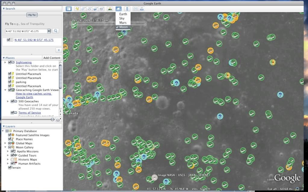
There's plenty of caches on the moon. To see them you have to load the Geocache Viewer kml into Google Earth Earth, switch GE to Moon mode, put N40° 51.592 W072° 45.175 into the search bar and hit go. You may have to zoom in a little to see all the caches.
-
-
Costco sells a 4 pack of hiking socks with the Kirkland brand name for $10. I compared the label to Smartwool socks and they are nearly identical, same ingredients, same percentages. Mine have seen a lot of use for two seasons and they're still like new. My feet are always warm and dry.
-
well found this one today off the blue gidle parkway,,,,it is called deer head
http://s163.photobucket.com/albums/t320/gl...esphotos017.jpg
that link doesn't work
Here it is


Problem with map on cache page.
in Website
Posted
As long as the old map is still available, and it is, I think it's a great addition to our arsenal of maps.