


Team LaLonde
-
Posts
426 -
Joined
-
Last visited
Posts posted by Team LaLonde
-
-
You would think that spending so much time in the woods, one would run across a moose (especially in moose country). Would you believe my only moose sighting was IN TOWN on my way home from work? We see plenty of moose tracks and droppings in the woods though so I know they are out there.

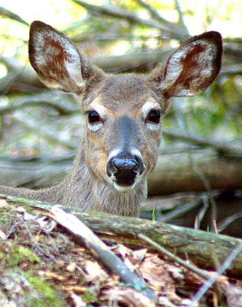
While caching we regularly see bald eagles, red-tailed hawks, deer, rabbits, snakes and the like. The deer on Presque Isle are so tame I accidentally walked right into a resting herd while following this doe. I thought she was alone but when I looked up there were six deer all around me.
The last bald eagles we saw were at Bald Mountain (GCXWJM) in January. We have seen an osprey, many lizards (Valley of Fire) and had a close up encounter with a very angry desert rabbit at Petrified Cache (GCJA5R). He was in a burrow in the rocks directly under the cache placement and I was blocking his exit with my knee. I've never heard a rabbit growl like that in my life!
-
I had a first-finder on the cache in question. Apparently my method of calculating led him to the right spot.
-
What is this series about? Stargate Caches
It's obviously some type of bug hotel. Do people mail TBs to and from these caches all over the world?
-
I don't know about any grave markers, but I hope my wife will put some of my ashes in a vial and turn me into a travel bug!

-
Here's our 5/5 - Higher Ground. First you must solve the puzzle, then take a canoe or kayak across a lake and climb a bit (non-technical climbing). The cache can be approached by using climbing gear from the north if you don't have a boat. When the lake is frozen the terrain rating is more like a two and a half.
-
Around here there are plenty of places that rent snow shoes so you can try different styles (aluminum frame, wood frame, etc.) before you buy. Renting might be a good option if you only need them once or twice. We have the wood-frame style.
Today we snowshoed to an island cache that was nearly a three mile walk round trip. Snowshoes are much cheaper than a boat!

-
The forum moderators on this site deserve thanks. They do a great job keeping it clean and on topic. Bravo!
In addition, we really like the fact that geocachers are of the same mentality of campers. Fun, respectful, outgoing, helpful people are the building blocks of geocaching.
-
-
For what it's worth - we have a neighbor who lets her branches grow into the street so far that they scrape the cars. I trimmed them in the middle of the night and got my butt chewed.

Every situation is different and you have to be prepared for the consequences. Go for it!
-
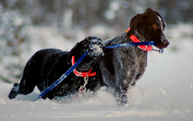
Our newest geodog, Dante!

Geoffrey pulls Dante through the snow.

-
The following is our Good, Bad and Ugly all rolled into one. GCY7AT - Treasures of the McCormick. I've linked this before but I'll share it for the newcomers. The September 17 log was our most memorable caching experience ever.
The short version is that you NEVER EVER EVER go into the woods without a flashlight for a 'quick grab'. Since there was heavy tree cover, we wandered for a few hours in the pitch black using our GPS as a light, not a navigational tool. The only thing that kept us from spending the night outside is our dog, who led us to the Jeep we were test driving. So far we are still the only finders.
Here is a link for McCormick Wilderness info: Backpacker's Link to the McCormick Wilderness
This is from the webpage - NOTE: There are only two maintained trails into this remote area. The Bentley trail is not maintained. Backpacking or hiking to the many waterfalls and interior lakes must be done by hiking through the woods and navigating with a compass or GPS. These navigating skills are essential if you plan to venture off trail within the McCormick Tract.
-
Thanks for all the input. I opted for Plan B. Frankly, choosing coords that I knew were not very accurate didn't seem like a responsible thing to do. Not that I'm a whiz or anything, but I trust my math and mapping skills more than I trust a GPSr with accuracy of nearly a hundred feet. I added a puzzle to the cache, making it our first 5/5.
Keep in mind that a true 5 on difficulty should be a serious challenge to find and require multiple trips to complete. A 5 on terrain is reserved for caches where special equipment is required to physically reach the cache location.
Most 5/5 caches are quite overrated on one scale or the other.
The cache can be accomplished by descending a cliff from the north or boating to the cliff from the south and climbing a short distance. Approaching from east or west is *nearly* impossible.
-
Thanks for all the input. I opted for Plan B. Frankly, choosing coords that I knew were not very accurate didn't seem like a responsible thing to do. Not that I'm a whiz or anything, but I trust my math and mapping skills more than I trust a GPSr with accuracy of nearly a hundred feet. I added a puzzle to the cache, making it our first 5/5.
-
We use the word 'team' in place of 'family'. With the exception of a couple of finds, there have been at least two and as many as eight family members on the hunt. Everyone in the team has their own job to make the find possible: Operating the GPSr, the PDA, the maps, the driving, handling the dog(s), sticking their hand or nose into a dark stump, etc. The fewer the family members on the hunt, the more responsibility per person (or dog).
Yup, we give the dogs a task. They are just as much a part of the family and team as anyone else. Geoffrey finds by scent - not well, but he's found some that we humans couldn't. Dante has not yet been on a cache hunt but he seems to have a keen sense of smell also. His first cache is tomorrow (Island Lost - GCGB39) across a frozen lake to an island.
-
I had trouble while hiding a difficult cache in the side of a cliff today. The cliff was on the edge of a lake in a cove so the GPSr naturally acted a bit strange. On top of that it was snowing so hard I could only see about 150 feet. I could not get a really good lock when I was on top of the cache, but the accuracy from out on the ice was good. I took several readings from both locations. I want to make sure the coordinates are as accurate as possible when submitted for the reviewer so how should I list them? Should I:
A. Use the coordinates straight from the GPSr at ground zero when the accuracy was 94 feet?
or
B. Use calculated coordinates from walking out into the open where the accuracy is 24 feet and work the numbers with an estimated distance and bearing?
Mapsource calculates the distance between the two locations (GZ and clear ice) as 528 feet when the actual distance was about 40 feet. My gut tells me to go with Option B.

-
I use the the icon in the "sure, it's possible" context. Most people will automatically know that the cache will be more difficult in the winter, but the icon shows that it's not impossible.
When I look at it from your viewpoint I see that I may be using the icon improperly.
-
We have camped while caching. There's nothing like waking up before sunrise and heading to the next cache to watch the sunrise! Oh, the memories. . .
-
We have two "myspaces" - one for the geodogs and one for my photography.
Dante and Geoffrey, our geopups

-
Geocaching is not the first place I've seen the practice of taunting. For what it's worth, a little friendly ribbing is cool with me. It keeps the competition lively. If you left a note saying, "Hey Team LaLonde, you're effing losers!" then I might have a different opinion.
The following is a good example of unsportsmanlike taunting: During the Desert Storm campaign, the 101st Airborne Division had 'kill cards' they left after destroying enemy tanks. They resembled playing cards with the ace of spades on one side and a personified bulldog flexing a bicep on the other, with the message "101st Airborne, World's Largest Supplier of Used Tank Parts". They also had 'confirmed kill' stickers. I know this practice existed because I ran the presses that printed them - by the thousands.
That takes the 'neener, neener' thing to a whole new level.
-
Don't forget about the island caches that become drive-ups. That's a real bonus!
-
you sure about that web page? I went there and found the Torino scale. *shudder*
What a cool idea. . .a geocache disguised as a meteor crash site!
I think TX Magic Lady meant this Stump Cooler.
-
We are quickly learning that placing a cache in the winter is even more challenging than finding one.
Last weekend we spent two and a half hours hiking through snow and only made it half way to the proposed site of the cache hide. The ammo can (containing a complete original Sony Playstation) remains in the wilderness but nearly a full mile from it's destination. It will be at least two more weeks before we get back out to finish the hide. I'm sure it will take another day to plant false tracks so the FTF can't walk right to the box. Oh, wait - the bridgeless river and rugged terrain will keep that from happening.

Oh, oh, oh... I used to be such a big fan of yours. Why do you gotta be so mean? +1 mile hike...in the SNOW!?! Not a fan any more. Now I wanna be you when I grow up!! You have no idea how much you guys make me wish we could move back up

It was -15F @ 7:00 this morning. You still want to come back up? Caching is on hold for us right now. As much as we like winter, -15F is too cold for the dogs to be outside for an extended period of time.
When you do make it back up here, try one of our newest hides - 'Take Me To The River'. It's not a long hike (less than three hundred feet) but it's quite difficult, especially in the winter. Bring warm, dry clothes and waders might be necessary in the cold months.
-
There is a cache in Marquette, MI that is a decent size container hidden with a large magnet under a specially made park bench. City workers moved the bench to a new location and never realized the container was attached. How's that for a good hide?
-
We got our second geodog a few weeks ago. His name is Dante and is the black one in the photo. Geoffrey is our first geodog (second in the pic, German Shorthair) and he's found several caches when we could not.
Dante is a pound puppy who's growing at an alarming rate. We were told he was a black lab/shorthair mix but the vet seems to think there might be some Newfoundland in there somewhere.
Note the reflective orange collars for safety!


Koko Needs Inspiration
in General geocaching topics
Posted
We found a micro on a street corner (hanging from the walk/don't walk sign) in a large city. Afterwards we joked about how embarrasing it would have been if I had waited in the car and let my wife stand on the street corner for fifteen minutes trying to look inconspicuous.