


coggins
-
Posts
2592 -
Joined
-
Last visited
Posts posted by coggins
-
-
-
Actually, I believe you meant to say ≈17.77777777777778 times and not double.
Path, just use FizzyCalc to accurately project your waypoint:
-
It won't ever show, mass storage only shows the microSD card. This is where maps can be installed. You are best to use MapSource to install maps to the gps.mass storage mode is good for getting archived tracks off the card.
-
You guys must all be using the newer version of Basecamp. What's left for users of older Windows boxes doesn't seem to have all of the same functionality.
Those instruction are for BaseCamp for Mac to answer the OP:
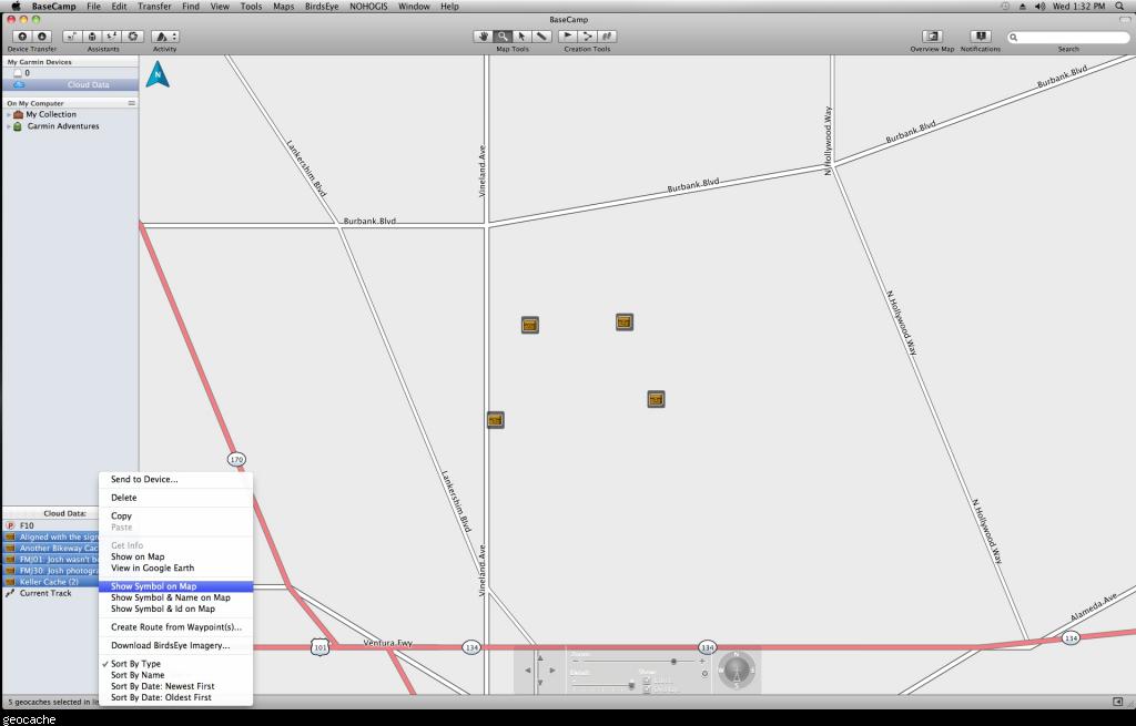
I am using Basecamp on my mac and gan't for the life of me figure out how to get rid of the names of each cache next to each icon. The names take up so much space on the screen I can't see the map. Any and all help is appreciated. Thanks
You should know that the Windows version can't do this.

-
Rather than nuking everything, I much prefer to see just GC codes. That's not do-able natively with either Basecamp or Mapsource AFAIK. That's why the waypoint name gets translated to "%drop2" here in GSAK. If I want to know the actual name, I can always bring up the properties for any of them on the map. It's a lot easier to manage "34RVQ" on the map than it is "November 26th ~Shopping Reminder Day".
That is accomplished in BaseCamp for Macintosh by selecting the third option "Show Symbol & Id on Map" as shown in the image I posted above.
-
I am using Basecamp on my mac and gan't for the life of me figure out how to get rid of the names of each cache next to each icon. The names take up so much space on the screen I can't see the map. Any and all help is appreciated. Thanks
- Select the geocahes you want to change the display on, shift click to select multiples
- hold the Control key and click the mouse
- Select Show Symbol on Map from the popup menu
- Done, mystery solved.
Looks like this:
- Select the geocahes you want to change the display on, shift click to select multiples
-
good move.

-
I have a friend that says the touchscreen on the 600 is very sensitive, and that she has accidentally reset the unit on more than one occasion.
A review of the 600 says that a NiMH battery pack is a option, and that you can recharge it with USB. Now, what about NiMH AA's? Will the USB recharge those? I already have a very good charger, I might want to use that instead. If necessary, can the built in charging circuitry be disabled?
Because it is Android-based, can you download apps that use GPS and use them on the unit?
On my Oregon 450, I have a rubberized (silicone) case that is actually made for another unit (I think the Montanas) but it fits great. Is there anything like this, or any other case for the Oregon 600? What about screen protectors?
<more questions as I think of them>
thanks
Tell your friend to go to Setup->Accessibility->Touch Sensitivity-> then switch from High to Normal
You can charge a pair of NiMH if you close the switch between the cells. There is another thread here that explains this.
Why do you think it is Android based like the Monterra? I don't see anything in the copyright info mentioning anything that would point to that being so.
I got the GizzMoVest case for mine as well as an ArmorSuit military shield screen protector. Money well spent as I'm pretty hard on my gear ?
BlueTooth works well with the iPhone pulling data off the cloud, try that with an eTrex
-
- Set it to Fixed Elevation
- Turn off Auto Calibration
The tracklog will then record the GPS elevation just like the other Garmins that do not have Barometers.
- Set it to Fixed Elevation
-
Next time start your research at the product webpage, here is the image from garmin.com:Doing research and find out that the map that's advertised on the box is NOT the map that comes with the unit.
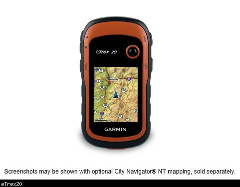
Notice the text under the picture.
Also, it mentions on the box that the pictured maps are optional.
BTW, this is what Bait-and-switch means:
Bait-and-switch is a form of fraud used in retail sales but also employed in other contexts. First, customers are "baited" by merchants' advertising products or services at a low price, but when customers visit the store, they discover that the advertised goods are not available, or the customers are pressured by sales people to consider similar, but higher priced items ("switching").So if you were "baited" with an eTrex 10 for US$50.00, but they were magically sold out and a salesman "switched" you to an eTrex 20 for $200.00, that is a Bait-and-switch.
Also, Garmin just announced the eTrex 20x retailing for the same price as the eTrex 20. Paying almost US$200 for the eTrex 20 at this time is not a wise decision.
So in answer to your query, no that is not a Bait-and-switch.
-
Cool, thanks for the heads-up, just called in an order.In case you haven't received the flyer for REI's upcoming sale, the Garmin Oregon 600 will be priced at $220 (down from $400). The sale starts Friday (May 15) and runs until the 25.
-
Let the gps auto archive the tracks then when you get home the time stamp will still be there.
-
Yep, it means you're trying to load a bad map. Roll back the last non Garmin map you updated and contact the map author and let them know to fix it.
-
Looks like the Garmin cart mount would work
-
Install BaseCamp for Macintosh on the MacBook Air, open the .gpx files and send them via USB to your Garmin.
-
Excellent that you had it returned. Btw, Staples has a deal of the day today on lifeproof case for iPads. $25 for mini & $35 for normal. I think that's about $100ish off.
-
Wrong forum, go here: UK Geocaching Car Boot Sale
http://forums.Groundspeak.com/GC/index.php?showtopic=297142&view=getnewpost
-
Lots of talk on open street maps but wasn't the op looking for topo maps? That's what I took from the thread title.
-
Help, I am desparate. Since i bought this GPS i can't find caches anymore or very few... My GPS is so off, its crazy.
I tested it with cache that i know and every time he send me about 42 meter in an another direction.
I am about to trow it in the wood...not in the water because it float, and get me another one. Before this one i had The GPS map 60CSX...oh what a marvellous little machine, but i lost it during a vacation.
So is it possible that i need to calibrate it ? and how do you do this ?
I tried changing option, changing the navigation map, at one point you try anything, no,nothing solve my problem, its always off.
Please, anybody, can you help me ?
Thank you, very much.
You calibrate the 76CSx just like you did with your 60CSx. They are both basically the same unit.
Except he doesn't have a 76CSx, he has a 76Cx. No sensors to calibrate.
-
So, will the iphone5 GPS work in airplane mode??? Kinda important while out and about for days backpacking & saving batteries!
My iPhone 5 in airplane mode still receives GPS location. As a test, I turned on Airplane Mode then opened Spyglass, a GPS app and location services worked. I then took a photo with the standard camera app and checked the imange in a 3rd party EXIF app and the GPS location was written into the photo header. So my testing shows that my iphone 5 in Airplane Mode will still receive GPS data.
That apple knowledge base article was dated 2012 before the iPhone 5 was released, so things might have changed.
Interesting. My iphone 5 GPS does not work in airplane mode. The compass works because that is a separate system, but from what I determine the gps and cellular share hardware. According to motion x, all satellites are lost as soon as I turn on airplane mode. 20 minutes later, it still states that the app is searching for satellites.
If I turn off airplane mode - without cellular or wifi - it picks up satellites right away. But when I turn airplane mode on I lose them again and my caching app stops updating my location. Motion x still advises that the iPhone 5 does not work in airplane mode and that apps cannot override this.
Maybe mine is getting GPS location from my SatSleeve iPhone adaptor then. I'll try it again with that off when I get a chance.
-
-
So, will the iphone5 GPS work in airplane mode??? Kinda important while out and about for days backpacking & saving batteries!
My iPhone 5 in airplane mode still receives GPS location. As a test, I turned on Airplane Mode then opened Spyglass, a GPS app and location services worked. I then took a photo with the standard camera app and checked the imange in a 3rd party EXIF app and the GPS location was written into the photo header. So my testing shows that my iphone 5 in Airplane Mode will still receive GPS data.
That apple knowledge base article was dated 2012 before the iPhone 5 was released, so things might have changed.
-
What's a Garmin Colorado 600? Never mind, must have been a typo.
-
Good grief, why didn't you post on their forum?

Garmin 64ST mass storage question
in GPS technology and devices
Posted
Maybe set interface to spanner mode