

jdwest32
-
Posts
65 -
Joined
-
Last visited
Posts posted by jdwest32
-
-
It's time for me to buy GPS, been considering it for months...
I'm really having a tough time deciding which unit and software, I want it to be useful for road trips offering turn by turn directions, capable of running topo maps and be combatable with a good software like National Geographic. I will be using it for road trips, 4x4ing, camping and maybe hiking. What I really want to do is upload 4x4 trails that friends have completed and be able to follow their tracks. I then want to upload my tracks to a nice topo map.
The Garmin 60csx seems the most popular and gets good reviews, it's on sale right now for $350 -$50 rebate. But I'd have to buy Streets $100 and Topo $60 Bringing the total the $460 AND it's recommended that I buy another topo software for planning on my laptop since Garmins software isn't that good (NG topo $100)......a total of $560. This unit seems tried and true. I'm not usally the type of guy who needs the latest and greatest, but is the technology becoming outdated?
I really like the idea of the Delorme Earthmate unit, it comes with topo and street software and the maps seem to be really good. But reviews have been mixed, I've heard it's slow and not good for using on streets because the auto-route function is not good. On the other hand some have said it’s great.
The new Magellan Triton that comes out in November and it looks sweet but, I need one sooner than that.
So guys what do you think?
My advice is to buy a Garmin. I use the 76CSx. it will do everything you want to do and more. There is lots of sowtware available and you can import geocaches directly from geocaching.com. Yes you will need National Geographic. I have it and also TOPO2008 and I am about to buy city NT v8
I also own 2 magellans and I prefer garmin. last thing, as with all things, you get what you pay for. Go with the Garmin.
-
I am looking at buying a topo software to be able to print good quality paper maps to take with us. Do any of you know whether the National Geographic Topo or Delorme Topo will print full size 1:24,000 maps (assuming you have a plotter etc.) that are as good as those from USGS?
I use National Geographic. I have the State series 1:24,000 for the state I use the most (AZ) and Backroads explorer for the rest of the US which is 1:100,000. I have made some very nice maps with them. If you dont have good quality printer you can take the saved image to staples as a pdf and they will print and laminate it for you. If you make it poster size it can get expensive. I got a quote fro them that is 24"x36" printed out, laminated and mounted in a nice frame for $72. I got 3 11"x17" prints laminated for $4 ( I think, I don't remember but it was cheap)

National Goegraphic prints to pdf or saves as a Tiff, bmp, jpeg...etc...
-
Hi
I cannot seem to add any more maps to my usit and I have plenty of space left on my 2GB card. Any ideas. I have city nav 6 and topo2008 right now.
2025 map segments are all that can be downloaded to a Garmin unit. The Topo2008 is the one that is using up most of that, I suppose.
How do I see how many segments I have installed?
If you saved the MapSource file you used to compile the maps to send to the GPS, look on the Maps tab on the left. It will have the number of segments in parentheses. If you didn't save it I don't know, other than to download the maps to MapSource and then do the above. I think the card will just have a "gmapsupp.img" file, which won't tell you the number of segments
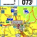
that is strange. mine says Maps(420) I can take a screen shot if that helps.

-
thanks, any idea if that number could be increased in a sw update or if it is a hw limitation.
-
Thanks SergZak. I thought the disk version would allow more flexibility. Besides, I know I would end up losing the little card!
Buy the disk version and buy a MicroSD from someone else. There are plenty of good deals on those.
-
I have a Garmin 76csx. If I get this battery powered USB port (https://www.electroids.com/main.php?content=store), is the Garmin voltage regulated at the USB port, or is just the circle port in the back regulated? I would like to use this gadget as a battery backup for my Garmin in the field.
Thanks.
I dont think I would want to risk it on a $450 76CSx. I keep 6 spare AAs in my carying case and I keep it plugged into my cigarette lighter when I am in my pickup.

-
Hi
I cannot seem to add any more maps to my usit and I have plenty of space left on my 2GB card. Any ideas. I have city nav 6 and topo2008 right now.
2025 map segments are all that can be downloaded to a Garmin unit. The Topo2008 is the one that is using up most of that, I suppose.
How do I see how many segments I have installed?

-
is it just a 76 or a 76CSx?
-
you can get them at REI or Cabelas
-
you can get them at REI or Cabelas
-
I have a 76CSx and I love it. They do make a handle bar mount for it but remember that it is quite big. It has expandable and removable memory in the form of a micor SD card.
-
You're right. The 76csx does come with a 128mb card. I checked the gpscity.com website. I guess I'll have to buy another card if I want street maps.
Chuck - 128mb of MetroGuide would give you all of Michigan, including the UP; the eastern half of Wisconsin; about 3/4 of Illinois; the northern 3/4 of Indiana; most of Ohio; and, pieces of Pennsylvania and West Virginia.
I have a 2GB card in mine but i guess it is overkill since there is a cap on how many map segments that can be loaded at one time. Which completely sucks in my opinion...

-
Hi
I cannot seem to add any more maps to my usit and I have plenty of space left on my 2GB card. Any ideas. I have city nav 6 and topo2008 right now.
2025 map segments are all that can be downloaded to a Garmin unit. The Topo2008 is the one that is using up most of that, I suppose.
I hope they can change/fix that in an upcomming SW update.
-
Hi
I cannot seem to add any more maps to my usit and I have plenty of space left on my 2GB card. Any ideas. I have city nav 6 and topo2008 right now.

-
mine showed up without the liquid. I just got the replacement yesterday and have not tried it yet. what sucks is my dog stepped on my 76CSx and scratched it before i could put it on.
-
Assuming your Google Earth is the latest version, is your MapSource program updated to 6.12.4?
I do now.
 Thanks...
j
-
^ I hear you on that. I wish we could have auto updates.
-
I have a similar problem but mine says that google earth is not installed. it is installed and i have uninstalled and reinstalled it too.
-
so far i can tell its more detailed in AZ
-
Update on my above review:
I loaded the maps on my 60CSx, and the roads show very nicely. the contour lines are light brown, whereas the roads and trails show up nice and dark.
I pretty much see the same thing as this guy sees....
my old topo was a little different. I am viewing on a 76CSx. either way it looks good to me

-
I use the Garmin 76CSx.
It's a great unit. a bit pricy but you get what you pay for.
Geocaching.com supports Garmin only for transferring waypoints directly to the unit.
-
I got mine in the mail yesterday. I'm just starting to play with it but one thing i noticed right away was that there are more roads and the color scheme is different.
Care to expand? AFAI can tell the color scheme is the same...
i dont have it right in fornt of me right now but... the color is a little bit darker brown. I can take a screen shot tonight if you are interested. I dont think it is bad by any means. just a little different.
-
Hi, difference between the two units is like the difference of women's haircolor. You make your pick, you live with it. Better idea would be to handle the two units blindfolded for a while, then use the buttons on each with one hand while making a cellphone call.
Both would float, but if you use a larnyard both don't need to float, they are not floatation devices, neither your Leatherman tool.
Myself - I married the redhead.
I went with the blonde.
I have the 76CSx and i love it. Some people think the operation is strange since the buttons are on top. it is kinda like working it upside down. well i thought so at first too. then i got used to it. No worries living with my decision. one thing i really like about it is that the screen is sunken in a little thus protecting it from scratches. the 60CSx's screen sticks out and could be scratched more easily. or you could put some protective tape on it.
-
Quijote, you should call Garmin. A 60CS is still a fine unit and they might replace it for you at no cost depending on the circumstances. If the unit died on its own (e.g. USB connector crapped out) then that is as likely to be workmanship defect as your fault. Even if you end up having to pay for a repair, it is worth more than the $150 they will charge you for the repair (they send you a different, refurbished or new unit of the same model). Also, if you have maps with unlock codes for your current unit, when you use this "repair" route, Garmin should send you replacement unlock codes as well at no charge (but you have to ask for that). I have replaced my Garmin iQue several times and each time they provided me with replacement unlock codes for my old map set.
Yes. Call them. Everything I have heard is that they are pretty good about returns...even if out of warranty.


 Thanks...

Hunting GPS choice
in GPS technology and devices
Posted
I hunt alot too and I love my Garmin 76CSx. I have TOPO 2008 loaded ant the detail is great. It is 1:100,000 I wish it were 1:24,000 but it is still really good. It has most of the roads and adding wps is easy. there is enough text in the wp file to let em remember which one is which. I use National Geographic TOPO! to plan my trips and all of my data easily loads to it. I have not figured out how to draw fencelines. I dont think you can.