


Blue Power Ranger
-
Posts
835 -
Joined
-
Last visited
Posts posted by Blue Power Ranger
-
-
Sorry we haven't been following this thread - we would like to get 10 if there are still some left. I am also calling my dad R-L-Painter because I am sure he would want some. Please let me know.
Thanks!
-
During an urban hunt this past weekend, I discovered quite the drug stash in a zippered pouch hidden in the bushes near the cache. Pills, syringes, etc. All gone now.
-
I've learned that if you're going to use the craft foam, try to get the 3mm thick instead of the 2mm thick. Also you can take individual coin sleeves, which can usually be bought where the pages are, and cut off the open end to make them approximately square. then turn them so the closed end is up, put your coin in the sleeve, then insert the sleeve in the page. This encloses it all the way around and they won't fall out.
Actually, just buy 6mm foam. The coins will not slip out.
I recently did this after seeing musneaker's album at an event. I used the 3 mm - does the 6mm still fit into regular baseball card sleeves?
-
I spent several years in Germany and used to have a vast collection of these toys.
They rock and would make great swag.
-
Something I always tell somebody new that I introduce to caching is, that when they get to what the GPS thinks is ground zero, just stop and do a visual scan of the area. Look for subtle hints in the area. Any grass particularly matted down in one place. Any peculiar "trail for no reason" to a certain stump or tree? You may even notice bark worn off a log that has been stepped on or over many times for "no reason". Just taking a minute to visually scan for environmental clues helps a great deal for me.
This tends to get easier with experience. When you find a cache, take a step back and look for signs that may have let you there more quickly. Generally, you will see something that could have tipped you off to the location that may help you on your next hunt.
-
My favorite thing about FTF attempts is that that is when I am most likely to get to visit and search with other cachers. Shared FTFs are just fine for most people. If you keep a list, give credit to the co-.
-
We have had the 2006 Sinterklaas geocoin.
tot cache,
team Wij Drie

That is one we would love to see. We put our wooden shoes out every year.
We love Dutch Holidays!
-
Has everyone in this area gotten their red jeep? I signed up for it but am wondering if it didn't go through right?

-
Email sent - thanks.
-
R-L-Painter is a definite now. He will be driving up with me and reijojo early in the morning.
-
I think this new practice is both unethical and unfair to the many users of geocaching.com.
How could a business like this making money through advertising be unethical or unfair? Groundspeak provides a great service for a minimal cost even to Premium Members. More revenue means more functionality and features for us users.
-
Does anyone have coordinates for the trailhead by chance? Or just an explanation of where the trailhead is at Paradise? When it's that early in the morning, I want to make sure I head to the right place from the start.

N46 47.183 W121 44.185
Just so everyone knows, there is very limited parking right at the trailhead right now due to construction. Last weekend a lot of folks were parking down the road or in the visitor's center parking lot.
Edit: Just spoke with reijojo, looks like we may have to go earlier than 7 after all due to some late afternoon commitments he has to be back for. I'm sure we'll meet you all on the trail. We will have FRS radios on channel 2.
-
 I have a babysitter coming at 6:30am I can not start earlier then 7am. 7am is early morning to me! If it is decided to go earlier then that please let me know right away so I can cancel the babysitter and stay home. If I have to hike alone there is no reason for me to spend a small fortune on a babysitter. If I'm hiking alone I can wait until my husband has a day off and have him watch the kids.
Oh don't do anything like that! I'll be there at 7:00 then.
Looks like this is going to be a lot of fun.
-
Are there going to be any avail as a single coin? If so, I am interested in the one on the bottom left.
Thanks!
-
I've managed a kitchen pass for this and will be there but have to start early (5:00 AMish) so I can arrive on Bainbridge Island by 4:00 PM for a family thing. Sigh. What we won't do for a cache. If anyone else can't sleep, I'd enjoy the company.
If you stop by our campsite on the way, I might join you. I don't sleep that well camping, anyway.
And real bummer that EraSeek and Moun10Bike can't join us - besides their great company, which will be missed, they've done this trek before.
Uh, not to change the whole plan or anything, but I'm kinda interested in an earlier start time myself. When we were up there last week, we found that the early morning hiking was a breeze on the hard frozen snow. As the morning progressed, and the snow softened became more difficult to slog through.
-
Although the Banana Slugs & High Places cache is no longer part of the WA History Challenge, this trip is still on - I think most of us want to make this trek, regardless. It should be spectactular!

Below are info and attendance updates.
Confirming a few details about our group outing to Camp Muir at Mount Rainier for the Banana Slugs & High Places cache:
- Date: Saturday, June 30
- Meeting spot: Trailhead at Paradise
- Departure time: 7:00 am
- Camping: Cougar Rock is the nearest campground. Several of us are camping there on Friday night.
- Distance: 9 miles RT, elevation gain 4600 ft
- Duration: 6-9 hours, depending on fitness and weather
- Weather report: Daily Hourly
- Muir Trail: Hiking details and Map and compass bearings
- Recent trip reports: June 2 and June 3
Attendees
Current status for June 30 outing, with Cougar Rock campsites.
Definite
hydnsek - C34
Cruiser Guy (+5) - C33, C35, C36
Forty-n-Eight - C32
AndrewRJ - C28
luckykoi - C31
EraSeek - driving down that morning
Moun10Bike - riding with EraSeek
MarcusArelius - driving down that morning
cache ahead - with hydnsek
Maybe
ruck - driving down that morning
-Hawk- driving down that morning
love<3 - driving down that morning
LandRover
Blue Power Ranger
nolenator
grossi
k7-wave
We can add reijojo to the definate list along with me. This is my brother-in-law. He has accompanied me to many caches but just now finally signed up on the site himself.
- Date: Saturday, June 30
-
Darn.
I was in the area last summer but just ran out of time to do this one. I figured I'd be back later. Never figured the cache wouldn't be there anymore.
"Never put off until tomorrow..."
-
Quick question... Are cachers that are heading up on Saturday bringing along FRS radios?
Just curious if there will be a way to keep contact with eachother up there.
-
You can add me to the FOR SURE list for next Saturday. I'll probably have a guest or two with me.
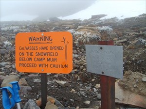
My wife, 12-year-old daugher, brother-in-law and I actually took a crack at this one and ended up turning back just 1/4 of a mile short of Muir at N46 49.887 W121 43.798, Elev. 9665ft. It was actually a tough decision to turn back when we did after all the work it took to get there. Our strategy was to go very light on gear and get up and down as quickly as possible.
This strategy took out any wiggle-room we might have to deal with adverse weather. When we got as far as we did, a very sudden wind picked up, visibility dropped to less than 100ft. It went from being quite warm and comfortable to very cold in a matter of seconds. We really wanted to get there but I feel good about our decision to head down when we did. We made a plan and stuck with it. I did log a DNF on the cache.
A couple of thoughts...
The snow starting right from the parking lot at Paradise up made for a difficult hike. The snow started with a good firm crust of ice but as the day progressed, we were hiking if very sloppy slushy conditions. My boot which were labled "water-proof" were anything but. The did seem to do a great job of holding the water in though. The only two areas that I wished I had brought better equipment for were my boots and my gloves. Both became uncomfortable.
We each carried about 120oz. of water and ended up using about 1/2 of it. Same with the food we carried. We brought way too much candy type food but ended up eating very little of it.
I can't wait to get back up there next week and finish this off. This will bug me all week.
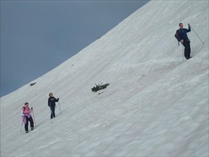
Climbing out of Paradise.
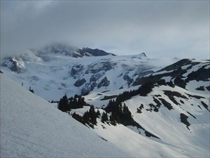
First good view towards our goal.
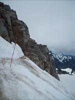
The trail just below Pebble Creek.
At Pebble Creek.
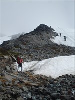
Starting the Muir Snowfield.
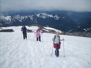
This was WAY steeper in person.
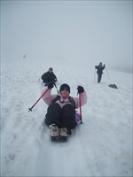
The glissade was the best part!
-
If there is anyone going that will be anywhere between Redmond and Olympia, I would be happy to pick our up from you.
Edit: Nevermind, got them in the mail today. I didn't remember paying shipping. Can I pay the difference?
-
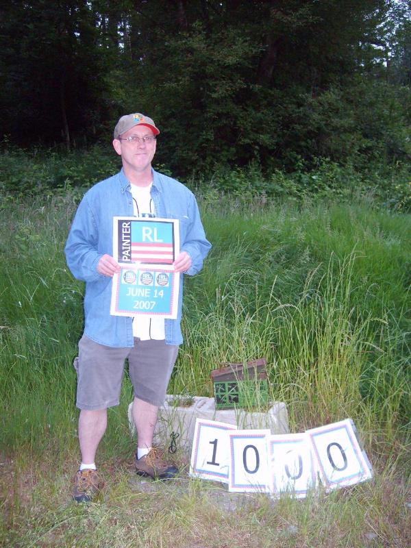
34 Painter RL (-- Waiting on Reply --)
This is my (Mrs. BPR) dad. He can be contacted through his profile R-L-Painter.
He may not be trading because he only ordered 25 - but you never know.
-
Congrats FunnyNose on 4K!
Congratulations FunnyNose!!
I am sending out a congratualtions ahead of time to my (Mrs. BPR's) dad - R-L-Painter. He will be getting his 1000 tonight at Captain Wapato's Treasure Hunt. We are going to have a BBQ there, then go along with him on one of our favorite multi caches. I will have to post pictures later.
After 1000, not sure if my mom is happy we introduced him to this or not.

Edit:
Woo Hoo!
-
Hope this isn't a silly question... are dogs allowed on this trail? I have a well behaved Border Collie (excellent protection on the trail for when I'm out hiking/caching alone day or night) that is just dying to come along. Oh, and my 77 year old dad is pretty good protection too, and he'll probably be near the front of the pack on this adventure!
(He and my mom were recently dubbed the 'Bionic Couple' on a hiking trip to Machu Picchu.)We have done the APE cache with our dog. We actually just tied a little LED light or something around his collar to keep track of him in the tunnel.
This would be a nifty doggie accessory for this hike.

-
Dang......it was worth a try.....and if you don't get one by the real one, I was first with this kind of picture.


 I have a babysitter coming at 6:30am I can not start earlier then 7am. 7am is early morning to me! If it is decided to go earlier then that please let me know right away so I can cancel the babysitter and stay home. If I have to hike alone there is no reason for me to spend a small fortune on a babysitter. If I'm hiking alone I can wait until my husband has a day off and have him watch the kids.

surplus ammo can purchase database
in Northwest
Posted
If you do it again, we would be interested in some. Probably 15 or so.
My dad, R-L-Painter would probably get 5 or 10 too. I am answering for him because he never comes to the forums.