


Oilman
-
Posts
25 -
Joined
-
Last visited
Posts posted by Oilman
-
-
Thanks,
I could swear the profile I was using did not lock on roads before. I did not have this problem till a few weeks ago.
Thanks,
Oilman
-
I have a Oregon 550t and recently it has been snapping my position to the nearest road. Has anyone else had this problem or know how to fix it.
When I drive for a while and pull off the road, my position on the GPS states that I am still on the road. If I travel parallel the road, my position will move down the road rather then my true location. If I turn the unit off and on, it will show my true path location, but then it will start snapping my position back on the road.
Thanks,
Oilman
-
OK, I found the answer on another forum branch.
- Go to your Geocaching home page.
- on the right hand side, select "Access My Field Notes"
- click on post the log.
I guess Access my field notes not includes the Apple phone along with the Colorado and the GN
( A couple did not make it because I found a couple more caches then what are in the notes )
Oilman
-
Duh, nevermind. I found the info on a post from a couple days ago.
Thanks for the app.
Oilman
-
I placed this on another Forum, but it may be more appropriate here.
I used the iPhone app to log my finds through Field notes. Of the 15 caches I recorded on Friday, not one of the posts made it to the Geocaching site.
Suggestions?
Oilman
-
Kind of a double edged sword here. On Friday, I went out caching. In the morning, I found a multi cache and signed the log. The noticed last person who signed the log was 6 months previous. But between then and now, the cache page said that three other people had found it. I even noted this quote
"Took the kids and had an easy time with the first. As some of the others put it, coordinates took me to the middle of the path and we searched for about 45 minutes. Never did find. TFTC"
This was recorded as found.
But later in the day, I searched for a cache, and found the magnetic holder and base of the container. I "truly" did not find the cache because it was not there. I logged it as found because I found part of the container, then reported it as needs maintenance
 .
.Oilman
-
I got real excited when Groundspeak updated their iPhone application. You can now record field notes from your phone. Yes!!!! I do not have to write notes on all the caches that I find and then hope that I did not forget any of them either that night of several nights later when I am in front of a computer.
Well, I did some caching last weekend. I made about 15 finds, and I diligently posted all my finds using the field note section of the iPhone App ...
What happened to them? They disappeared into the realm of the either and never returned. Not one of the post I entered made it to Groundspeak. Luckily, I had my GPS path turned on when I drove around. I had to follow the path and locate all the caches that I picked up and re-enter all the information the old fashion way.
Anyone had any luck using this iPhone app?
Oilman
-
Y'all.
I recently got an Explorist XL as a gift. I am using it instead of my platinum, but I have run across several problems. I was wondering if anyone else has seen the same problems.
1. Re-set : occasionally ( about one a week ) the unit will reset itself when I turn it on. I have to re-set the language, maps, poi file, and geocache file when this happens.
2. Lock-ups ( from once a week to several times a day ) the unit will lock-up. I can not do anything to reset it except taking out the batteries. I can practically guarantee it will freeze if I zoom in/out on a large map to quick. I have to give the unit time to display the entire map before I zoom in/out and further.
3. Non-initiation. This has only happened a couple times. When I turn the unit on, it will not come on. The initial display screen will show, and I can pan to the satellite map and road map, but the machine does not get a lock; even while driving around under a cloudless sky. I have to turn the unit off, wait a few minutes, and turn it on again. Then it initiates right away.
Anyone else having similar issues?? I think I just need to take the thing in to have it looked at.
Oilman
-
OK, that is a great start. I found out that the Mississippi River Commission did not come into existence until 1879. Looking at the search by Shorelander I see that there are other monuments that have the exact same letters on it. I wonder how they distinguished them apart. There is one between Zimple and Ferret with XXMR on it also. The one I found is about 3 miles away.
I will see if the library in town can help me get the 1937 book it came from. Maybe it will have information on other old benchmarks.
Thanks for your help.
Oilman
-
I recently started benchmarking as a change from Geocaching. After browsing through a few posts I see that I should not make a denchmark as "Destroyed"
Sometimes is is very obeous they are not there: i.e. "on top of a 150 ft stack in the middle of a factory" in 1955, now the area is a subdivision of 2 story houses.
If I decide that a benchmark should be classified as "Destroyed", what is the best procedure to take.
Thanks,
Oilman
-
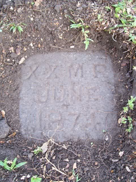
I recently found a benchmark monument at our local City Park. I got permission from the park officials before I bug it up. Afterwards, I showed them an image of the monument; they had no idea it was there nor any idea why it was there.
Monument AU1022 monument
It is a granite block with the following carved into the top of it
XXMR
June
1874
Does this mean anything to those with more benchmark experience then I. Both the park officials and I are trying to find information about this now.
Sorry for the light image, it was a bright sunny day and the monument was still covered in dirt.
Thanks,
Oilman
-
I am still jumping through all the hoops needed to install / update / link my Explorist XL GPS unit to the software provided. I kept getting a error that stated that some points in my Geocache file were to large and that they would not be displayed. It seems that Magellan placed a 200 point limit within their Geocache files?
Is this right, why the huge leap backwards in technology? Handheld GPS Unit have been stuck on the 500 point limit now for years and now they are going backwards instead of adding more.
Thanks,
Oilman
-
Y’all,
I got anew Explorist XL as a gift and I am attempting to load it with my data. I used spinner to rip the cache files so that I can distinguish between the cache sizes. I can load this file to the GPS with the software provided. When I go to open this file on the GPS it tells me that the file can not be loaded due to size limitations.
Any suggestions?
Thanks,
Oilman
-
From the Earthcache Submittal Guidelines:
To meet the Earthcache guidelines and be approved, your EarthCache MUST:* have received appropriate permission from the land owner or manager to place an EarthCache site on the land. For your EarthCache to be approved, you must list this information in the form below.
Every piece of land is owned and managed by someone or some entity. You've got to get the explicit okay from that authority, or the GSA won't approve the report.
-eP
Oh, well, then that might be an issue. I am trying to make some Earth caches dealing with the levee breaches in New Orleans. I do not think anyone from the Amry corps of Engineers nor the goverment will sign off on what I have to say about them ( both the levees and the corps ).
 . I live here, I have seen the evidence myself having gone to all of the failed levees in the city, and I am a geologist so I know what I am doing ( most of the time ).
 I will see if I can track something down.
Thanks,
Oilman
-
I need some help with trying to submit an EarthCache. I am using HTML tags in the code. I am under the character count on every one of the boxes.
Question 1. When I hit the submit button, here is the error I am getting. What is the problem?
Microsoft OLE DB Provider for ODBC Drivers error '80004005'
[Microsoft][ODBC SQL Server Driver]
Cannot create a row of size 9813 which is greater than the allowable maximum of 8060.
/forms/EarthCacheForm2.asp, line 131
Question 2. These two caches are on open / Public land ( it is not in any park system of any kind ). I am being forced to enter a telephone number but there is not one, so I am entering 111-111-1111. Is this a problem?
Thanks,
Oilman
-
I am still in Houston because of the storm, and I want to get away from the in-laws. I have a Meridian Platinum that I purchased two to three years ago. It was working perfectly until a couple of days ago. I was using it to track myself and the power quit. Now when I turn the unit on, I can not get past the initial screen. When I hit enter to go to the map, the screen will blank and return me to the initial information page. I tried replacing the batteries but that did not work. I tried to wipe the memory, but that did nothing also. It’s almost like the power keeps turning itself on and off. Anyone have any ideas?
I need to get out of this house before I hurt something.
Thanks,
Oilman, New Orleans ( the flooded big easy )
-
Since I like to where hats, I take my Geocaching floppy hat with me when we go out ( I see that they do not sell these anymore, too bad ). The cachers whom I run into know about the logo and stop to talk. The rest of the people have no idea why I am prawling through the bushes so they leave me alone.
Oilman
-
Not to pick on one area in particular, but southwest Houston is my next trip. I ran the Pocket query to see what it came up with and looked through the first 100 on the list during my lunch break. Here is a list of the traditional caches that are not at the posted coordinates.
The Bitter End GCHGY7
Anchor's Aweight GCHGYB
A Bridge II Far GCGAHR
Sinking Sandbar GCHAHG
OVERDUE GCH97J
Another Dark Side of Da MQQN GCJ3H8
Dash Dit Dash GCH7FE
I like the idea of having a Cache type as puzzle. Occasionally these can be fun and I have thought of a couple I would like to place out when I have time.
How would one go about finding out whom is the local coordinator, or approver of the caches?
Thanks,
Oilman
-
I was wondering if anyone else has this problem, and what they do about it. Since we travel a lot, we take full advantage of the pocket generator. I only search for traditional caches, large to medium containers. Lately, I have been finding a lot of new caches that are non-traditional, I.E. the caches start out by stating “This cache is not at the above coordinates”. You then have to solve some puzzle, calculate a speeding train distance, answer some other questions, or other nonsense, to find the true location.
Over the past six months, we have literally wasted hours and hours on them. We have been 1000 miles from home and are looking for “traditional” caches that do not exist where they state they are. And I do not want to spend hours looking through 400 pages to make sure they are all real caches each time before we travel.
Question:
Has anyone found a way around this? And, why are these being approved as traditional caches? Is there some way of removing these during the pocket generator run.
Please help stop the corruption of traditional caches.
Thanks,
Oilman
-
This was not my cache, but it did affect me. Someone in Wisconsin collected seven travel bug to place in a new TB cache. They placed in the Racine County Park. The next morning it was found by one cacher, but by that afternoon is was gone along with all of the travel bugs.
I replaced the stolen travel by with another item. The first person who picked it up in September has never placed it out again

 ( real mad ).
 -
So far while cacheing, we have seen several desert rattlers, a bunch of water moccasins, one woodlands rattlers and one coral snake. The coral snake was real cool; I had never seen one in the wild before. When we run across one, if it is next to the cache box, we just shoo it away with a stick. Other then that, we leave them be; they eat the mice and rats.
-
I have a couple of caches with travel bugs logged into them. One has been missing for a year now, and the other for several months. I have e-mailed the owners about removing them from the cache and placing them into a grave, but they have not done so. I have had several people e-mail me about the TB's not being in the cache and it is getting tiresome.
How do I remove them from the cache ?
Tim M...
-
I want to upgrade from my Meridian 320, and I am oscillating between the Meridian Platinum and the Meridian Color. Does anyone have a good reason why I should go one way or the other?
I have seen posts about the color being a battery hog and a pain in the butt to see in the daylight; is this correct? Is the color model 100$ extra for eye candy? Do these models have a 128 Meg limit, or can I use the 256 mem card?
What about purchasing locations? I was going to purchase from Compuplus, but they increased the price on the color $150 in the past couple of weeks. Most of the sites do not offer all of the extras (download/auto power cable, Mapsend, data loader, Mem card, ect.).
Thanks
Oilman
Tim M...
-
In the last year several of my travel bugs have gone missing. Geocachers say "look for the bug soon" and then that's the last time you ever see or hear anything.
Is this a common problem?

Tim M...
[This message was edited by Oilman & Fuzzylogic on January 29, 2003 at 10:21 PM.]
2 Google earth questions
in General geocaching topics
Posted
1. Multi point pathway.
I have used Google Earth several times to make a route. I then run this route through geocaching to find caches along this pathway. When I want to make several stops I have to make several point to point paths, then download them individually. These I piece together into one long path. Is there a way to make one path that has several stops along the way?
2. Fine the path.
At times my path is defined by to few points. Then when I use Geocaching to find caches along a route, the actual road is to far from the path defined within the route so it misses some of the caches. Is there a way to force Google Earth to use more points to define the path?
Thanks,
Oilman