


embra
-
Posts
5260 -
Joined
-
Last visited
Posts posted by embra
-
-
I have a hard time keeping that kind of information straight, but my recollection was that they said the imagery was "coming soon." So I guess the answer to your question is no.
That kind of leaves us reading tea leaves. I'm guessing that they are channeling most of their map energy into the Topo9 update right now, and that the new imagery may follow the release of T9. Since the Amazon oracle now calls for a June release of the PN-60, I'm guessing summer for the Canadian imagery.
Anybody else's guess has at least as much merit as mine.

-
Can you quantify this with actual tests you've done, or point to some other review with numbers?
There was this thread at the DeLorme forum with user reports of what they were seeing. It has its share of flaws, but by golly it has numbers.
My own report in that thread is below. Everyone should bear in mind that the windowsill rundown tests represent best-case scenarios, while field use comes in something shorter. How much shorter is not reported as much. It does appear, however, that NiMHs fare better than alkalines. The winter cold is hard on the NiMHs, though. My times had minimal exposure to the elements.
Batteries: NiMH 2650 mAh DuracellsMoving rundown: 9.5 hr - 4 hours of driving/tracking and the balance a route simulation. Full intensity constant display.
Stationary w/full intensity constant display: 11.2 hr
Stationary w/power-saving mode: 16.3 hr
-
Does a reboot make any difference?
-
Looks like the rebate is good at REI: $249 net.
-
I don't know how active it still is, but there was a very useful Meridian Users Group for a good while in Yahoo Groups. If it's still there, there would be some authoritative answers to questions. Also there might be some good information in the files area there. And besides Robert's FAQs, there are a few more relevant FAQs in the sticky at the top of this forum.
-
Doh! You have me wondering what I thought I was looking at!
A google search turns up some lower prices. I see Walmart looks pretty good, although it would be worthwhile sifting through to see if you can find any more places like Gander Mtn doing the rebate. It looks like the rebate is retailer-specific.
-
Is the rebate available with the Amazon package? If so, the Cache Register certificate would tip the balance for me...but $50 is $50.
-
This is going back to the dustbins of my memory, so I refreshed with a visit to Robert's Magellan FAQ for a more authoritative quote:
Mapsend Steets 1.0 - street level maps, very few POIs, can't print.Mapsend Steets & Destinations - street level maps, adds POIs for zoos, ATMs,
Mapsend Topo 4.20D - adds topographical contour lines and POIs for arches, springs, and such.
Mapsend Directroute 1.0 - New in 11/2003. Delivers turn by turn driving directions, additional POIs.
Mapsend Topo 3D - New in 12/2004. Combines a higher resolution topo data and POI than 4.20 with maps improved over DirectRoute.
The first three mutants use the same street data and are derived from the Tiger maps. DirectRoute and Topo 3D use data licensed from Navtech.
Should I buy Topo3D or Topo?Topo3D has higher resolution topo data (30m instead of 90m) and replaces the 90's vintage Tiger street maps with the Navteq street and POI data similar (though not identical to) that provided with DirectRoute. The older (Tiger-based) versions, oddly enough, contain more detailed road and trail data for things like roads inside state parks. Use the Magellan map preview page to contrast them.
Is it possible that you have the older Topo (with the more detailed forest roads) and the newer Topo3D? Some people carried both map types on their Meridians, using T3D most of the time for the newer road data, but falling back to the old Topo when they needed the missing back roads.
IIRC the Topo3D came out in v1, v2, and v3. I preferred the earliest of those three, as I think the maps were all the same but the later ones had more restrictive copy protection or something that I didn't like. No, wait...that was the DirectRoute. There must have been just one Topo3D.
Trails.com was of no value to me; I think all you could get were paper downloads of trail hikes after paying your annual membership fee.
Hopefully someone will corroborate my recollections and opinions...it's been a long time.
-
You're getting good advice here. I'd just put a plug in for spending the extra money on the smart chargers that have been mentioned. They offer much more information about each cell and have more charging options for maintaining battery health than do the cheap chargers. Although it may seem like a lot, it will pay for itself over the long haul in disposable battery savings. You can get by with a cheap charger, but you'll be much happier with the good 'uns.
-
...With a budget of $400-500, I'd also give serious consideration to buying both a low-end autorouting-specific GPS (I've seen new Garmin Nuvis well below $150) and a handheld for other uses. No handheld offers the voice prompts that are so useful for driving....
The Lowrance Endura Sierra and Safari with the autorouting add on will give voice prompts!!
I [gladly] stand corrected! How does the routing quality stand up to the Garmin handhelds? Voice prompts would seem to make these Enduras the GPS of choice for those who want a single GPS that does a lot of road routing.
-
DeLorme just came out with the PN-30 a few months ago; they will continue selling the PN-30 and the PN-40 for the foreseeable future. Having a variety of features and prices expands their market.
Teamplayer, I'm in agreement with Starbrand on this. It has seemed to me that as GPS devices have become more sophisticated, they have had more problems early in the release cycle, but these problems appear for the most part to get ironed out as time goes by. As long as you stick with a reasonably matured product, I think you'll be quite pleased.
I am one very fond of the DeLorme line, but Garmin still seems to do better on the autorouting feature. Although I've not used any of the Oregons myself, I think they might be your best bet at this point in time. But I would also take a look at the DeLorme and Lowrance offerings (shopping is half the fun).
With a budget of $400-500, I'd also give serious consideration to buying both a low-end autorouting-specific GPS (I've seen new Garmin Nuvis well below $150) and a handheld for other uses. No handheld offers the voice prompts that are so useful for driving.
Also remember that in forums like these, you will predominantly see discussions of problems, because this is a great place to do problem-solving. Fewer people post how great everything is going for them, even though there are likely many more users having no problems. Problems get over-represented in our communications, and we tend to over-estimate their prevalence.
-
I have a subscription to DeLorme's online library, and I've downloaded a few maps. My one big gripe is that the maps are only available to a 40 (80?) foot zoom level, and the clarity is a bit iffy at that resolution, making the maps less than perfect.
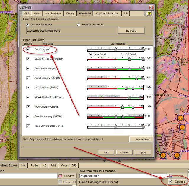
Take a look at your cut level sliders in the TopoUSA Options screen where you toggle on/off the data types to include in the cut. You may have to expand them to include other zoom levels. I tend to like the same zoom levels that CowboyPapa likes. (see here.)
Edit: I just caught that you said "available to" that low end...my advice is obviously of no use for that. I agree it would be nice to have better resolution for the closest zooms; it's perhaps a sour grapes observation on my part that the memory requirements would be higher for that kind of resolution.
-
It does have its quirks. If you search geocaches by name there is no way to search by name. You have to scroll through them all. The Explorist would let you scroll through the first letter then you would enter at the correct letter and scroll from there.
Try the Find function, filtering Type: Geocaches and specifying a couple of letters in the name. That seems to cut the list down nicely.
-
When I'm recharging my Li-Ion, I usually leave it going overnight. I'm not sure how much of that time is required, but I can attest it's sufficient.
I was going to suggest rechargeable NiMH AAs over the alkalines, but if you're only getting down to 50% on the power bars that's why the run times are so short (not that the PN-40 is that great anyway...dual processors use more energy that single core). Let us know how that turns out for you.
As mentioned above, the exposed contacts haven't seemed to be much of an issue--and they do offer the benifit of good waterproof integrity. Every once in a while you might have to clean them off with a pencil eraser if you're not getting good contact with the connecting cable.
-
On my 60CSX I tied a small piece of orange flagging tape to the antenna, which helps me find it when I put it down.
Great tip. If I get one of those black PN-60s, I'll be doing that.
-
Now my question is, that the Dakota 20, Oregon 400t, and Colorado 400t are all around the same price... Any major differences? I would love to get my hands on one to play with them myself and check them out, but unfortunately, none of the stores on base sell any GPSr's.
I know you said you've been reading reviews, but if you haven't checked out the GPSTracklog.com site, you'll find some nice comparison charts and reviews of those models.
-
In this blog post about some of DeLorme's plans for the coming year, they mentioned expanded international map coverage.
# We are releasing worldwide high resolution aerial imagery for the PN-Series devices as a new NetLink subscription. This subscription will be available for PN-60 owners with Topo USA 9.0 as well as owners with previous PN-Series devices and earlier versions of Topo USA.# The resolution of this imagery varies throughout the world but will be equal or better than that currently offered in the Map Library subscription for the US.
# We will release more information about the worldwide high resolution aerial imagery as development progresses.
# Our 1:250k world vector maps will also be offered through NetLink for purchase in small coverage areas. This dataset will appear in Topo USA and on the PN-Series devices giving more detailed roads to international users.
That's down the road, of course...and not spelled out just when this will be available. If I were to make a wild guess, I would think summer. (Whoops--toward the end of that post it looks like they are targeting May 1 for at least some of that stuff, the same time as they hope to get the PN-60 out.)
I wouldn't rule out the Oregons; users here seem right happy with them. There are a lot of free maps available for stateside, although I'm not aware of any such offerings for Japan. I poked around on the Garmin site and couldn't locate maps for Japan (although you can load the site in Japanese...I'm thinking I missed something). At the least, they have a worldwide basemap offering that gives not-very-detailed coverage.
Lowrance seems to be making a strong showing here of late, too, but I again couldn't verify that there are any map offerings for Japan with them. If I were you, I'd start with the maps and then find a GPS to use them on. As mentioned above, maps are not essential for geocaching, but they greatly enhance the utility of the device.
Good luck!
-
If speed was pretty much your only complaint with the PN-20, you should be right well pleased with the PN-30. Battery life will be a little bit less since you got that dual processor chugging away, but most of us who like the DeLormes feel that was a worthwhile price to pay.
-
Sometimes when traveling great distances between operations, the GPS will be confused as to where it's waking up. You can hasten that initial position acquisition by hitting Menu from the Satellite screen and choosing Set Current Location. You then give a map position assist and the PN will figure out where it is a little faster.
-
While this thread is near the top, I'll suggest adding the DeLorme FAQ/Wikis
http://delormepn40.wikispaces.com/ (the user wiki)
http://pn-series.wiki.delorme.com/ (the official DeLorme wiki)
-
I forgot to mention that I think there were some 5.xx firmware releases for the Meridians. Danged if I know where to get them now.
-
There's a Meridian FAQs link in the sticky at the top of this forum that should be of help to you.
It's been a while since I used a Meridian, but as I recall you can send waypoint files directly to the SD card. However, you have to have them in the Magellan format. GPSBabel or GSAK (using GPSBabel) can do that for you. The GPS itself won't be able to recognize any of the formats you listed. IIRC the format you need is a Magellan form of .wpt
-
To add to TL: on the Handheld Exchange tab, click on Options and make sure Draw Layers is toggled on.
-
Starbrand, I share Lee's curiosity. Since you're in a good cross-platform position to comment, could you say a little more about what you particularly like about the way Lowrance does geocaching?
It's good to see Lowrance ironing out the problems. I've come to the conclusion that one should expect a shakedown period with the release of a new GPS model. Even though I've seen from my own beta participation that a lot of bugs get weeded out, it seems very difficult to me to catch them all before the product goes into public release.
PN-30 or Colorado 300? or other?
in GPS technology and devices
Posted · Edited by embra
Right you are, Lee. I seem to be having a problem of late not paying very good attention to details...I keep answering the question I think I read rather than the question that was asked. Hope I didn't make you peruse that entire thread again. But part of my motivation was to offer some numbers for cr4zybilly that compared more favorably than what starbrand has observed.
FWIW, I'm not aware of any significant advantage of the PN-30 over the PN-40 in battery life, either (of course, I only have a PN-40 to look at). My understanding is that they are identical except for the compass and barometer sensors, and the sensors reportedly have a only a very small additional power draw.