


embra
-
Posts
5260 -
Joined
-
Last visited
Posts posted by embra
-
-
Any of the DeLorme Topo versions (7, 8, or the upcoming 9) should do what you want.
-
I'm not certain, but I think there's no distinction made on the PN-40's info fields for hiking vs. driving. I deal with it by setting the map screen info fields for what I want while doing a driving route, and the compass screen customization for hiking routes.
-
On this recent blog post where DeLorme said the PN-60 release is being set back until early July due to a component shortage
 , Caleb (their marketing guy) mentioned down in the comments that they are seeing 30 hours off a set of e-lithium AA's, with a prediction of as much as 50 hours (!) with power management enabled.
As I recall, people using lithium AA's reported something like 14 hours run time in the PN-40. Even if we take Caleb's report with a grain of salt, I'm optimistic that the PN-60 will be showing substantial improvement for all battery types over the PN-40.
Edit: I mis-read the post. The SPOT Communicator is involved with the component shortage, so the PN-60w (which pairs to the SPOT Communicator) is delayed until early July. The PN-60 is still on track for mid-June.
-
Are you using imagery on your maps? I get crisper performance using just the topo data--probably because the files are smaller as TotemLake alluded to.
-
My problem is that in my local area (Indianapolis) stores don't carry multiple brands of GPS (at least not the ones I want to try). I could get a PN-40 and return it, and I think there's an Oregon for sale in town, but I don't want to chance having trouble with the returns.
If you buy from an approved retailer (e.g., Amazon, REI, Cabella's) then DeLorme will honor the return policy. I think they've been very good about it; I've never heard of a problem on that front.
-
Does this help you Yogazoo? (I got busy with final exams this week).
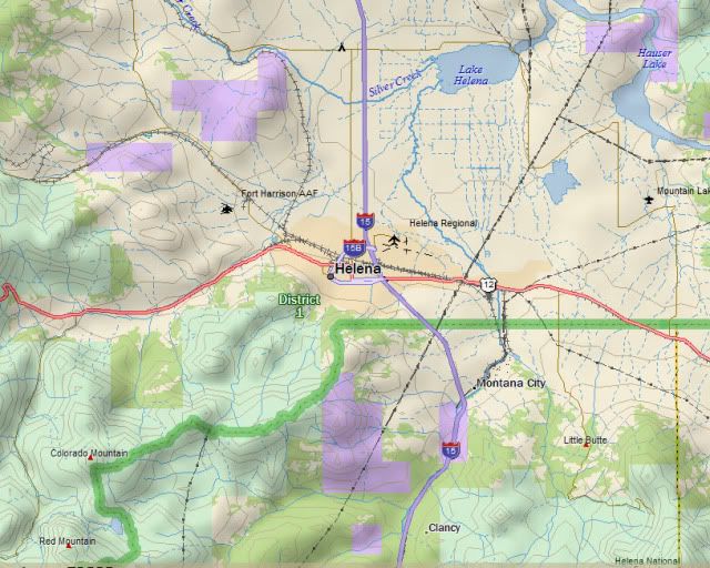
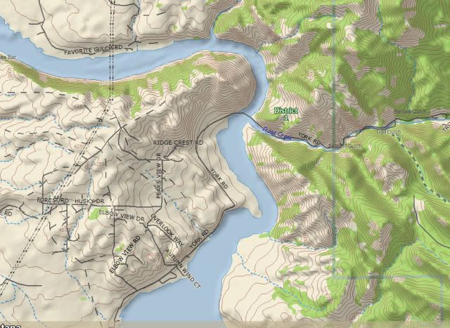
I think the purple areas are supposed to be public lands...you would know better than I what they actually represent in this case. However, they appear to be identified only in the base map. Below is a zoomed-in view of Hauser Lake. As best as I can see, there's no indication of those purple boundaries.
Topo8 does offer me a download of 208KB for Montana Game Management District data. For some odd reason, I am unable to download any of the game management data. I've never been able to figure out why, but since I don't need it I've never pursued it.
-
FWIW; one might not necessarily want to have improved resolution at the very close zooms, as it comes with a high price in memory demands. Those files can get whompin' huge if they cover much area.
-
They are nice features to have (the compass much more so for geocaching than the altimeter), but they are not necessary by any means. Just where you draw the line is a very subjective matter, though. Personally, I would pay $20-$30 more for an electronic compass, but I don't think I'd go for $50 more.
-
I think Amazon has been our best explicit predictor so far. The US site is saying June 10 at the moment.
-
Hank, FWIW I remember that not long after the PN-40 came out someone did a nice series of tracking comparisons between the PN-40 and the 60cs (I searched but couldn't come up with the thread, which was posted in this forum). My recollection was that the two performed comparably except in narrow slot canyons, where the quad antenna of the 60cs gave it an advantage over the PN-40's patch antenna.
It's not a bad choice to try it out for yourself. If you have any difficulty in returning it to the seller, DeLorme honors a 30-day satisfaction guarantee for any unit sold through an authorized retailer.
-
I think the most recent information released about this was in this blogpost.
Data updates…* We are releasing worldwide high resolution aerial imagery for the PN-Series devices as a new NetLink subscription. This subscription will be available for PN-60 owners with Topo USA 9.0 as well as owners with previous PN-Series devices and earlier versions of Topo USA.
* The resolution of this imagery varies throughout the world but will be equal or better than that currently offered in the Map Library subscription for the US.
* We will release more information about the worldwide high resolution aerial imagery as development progresses.
* Our 1:250k world vector maps will also be offered through NetLink for purchase in small coverage areas. This dataset will appear in Topo USA and on the PN-Series devices giving more detailed roads to international users.
It's your call as to whether this is enough information to take the chance that they will have what you want when you need it. I would guess the data should become available by some time this summer, but that's just a guess on my part. Note that the vectorized maps are 1:250K...although I'm not familiar with the Garmin offerings, I'd bet they are more detailed than what DeLorme will be offering. No word on pricing that I remember seeing.
-
If I remember right (and I may well remember wrong), didn't the cable allow it to run on external power? If so, that might be worth a try. The secret menu mentioned in the FAQs at the top of this forum might just possibly get a response if the regular power on sequence doesn't kick in.
If you can't get it to power on, I don't think there's much hope.
-
Probably the worst knock on it is battery life; you might expect 6 to 12 hours per set depending on battery type and some other factors. So I always carry an extra set or two. The autorouting is servicable, but not as good as the Garmins will do. Some people prefer a larger screen than the PN's offer.
I do think that the DeLormes offer very good value.
-
I agree with TotemLake...when you're moving, your compass gets its directions from the GPS satellites, but when you stop your magnetic compass takes over, and it periodically needs calibration to function properly.
-
Still hoping to hear about any Canadian Delorme users. Or should I just give up and deal with the touch screen?
Until very recently, DeLorme PNs were not available in Canada. Since DeLorme is expanding their coverage to include Canada, I think they are lining up Canadian retailers. There was a recent report that PNs had been sighted in an upcoming catalog for some large retailer. Unfortunately, I can't remember who and I can't find the post.
-
If you keep getting stuck at choosing a language, give a try accessing the secret menu system. I'd try executing #32 to clear all memory.
It's very strange that you can get 3.12 to work--sometimes--but nothing with anything else. I'm starting to wonder if you've got a hardware problem like some bad memory.
-
Idea: try downloading a new copy of the firmware. Sometimes you end up with a corrupted copy that might install, but not work right.
Don't know where you got the 5.40, but I'd suggest trying Allory's archive collection.
-
I had a Plat years ago, so my memory is a bit rusty. But my recollection is that there were some good features to get in the 5.xx firmware upgrades. I also seem to recall that newest was not necessarily the best, although I can't recall what the drawbacks were. If you can locate some slightly older firmwares (I'm thinking 5.12 or so) maybe you'll have better luck.
A better tip I can offer is to see if you can locate the Yahoo Meridian Users group. It probably has less action these days, but there was a lot of useful help there. You might find some useful help in the file area of that group.
Also check out the Meridian FAQs in the master FAQs thread at the top of this forum. Unfortunately, the problem you're describing sounds pretty strange to me.
-
Hmm...I think you may have identified the problem, Jay. I forget what the setting is in the GSAK export, but one needs to identify the cache by cache ID, not name only.
Edit: Found this brief discussion of relevance on the wiki.
-
Before going to a hard reset, I would try deleting the fieldnotes.txt (or whatever it's called) file in internal memory. Maybe the file is corrupted.
Connect in internal map transfer mode and browse to locate & delete the file (sounds like you know how to find it). Then try creating and uploading a few new fieldnotes.
-
You might give Amazon a call, explain the situation, and ask if they'll match their price for today.
-
I bought a Nuvi 255w through Amazon and have had no problems at all with it. IIRC it knocked something like 20% off the price of a brand-new device.
-
I'm most attracted by the SPOT pairing of the PN-60w and would buy just for that, but the OP was focused on just the 60.
The better battery life is a good plus, but not enough in itself to compel an upgrade for most of us, I would guess. The new interface looks pretty cool, but from what's been discussed so far I don't think we've seen much actual new functionality beyond the wireless...elevation profiles is one thing, though to me that's somewhat minor. So I'm not too sure how many PN-40 users will want to step up to the PN-60. We're going to have to see.
Upgrading to Topo9, OTOH, looks like some good money to spend if you want to get better management of the SD card support for multiple waypoint, track, and route files.
-
The PN-30 is Rastor based and lacks the 3-axis electronic compass or barometer and is paperless;
Slight correction: while it's true that the PN series uses rasterized imagery for the stuff available through the subscription downloads, it comes with the vector-based TopoUSA maps. So people usually end up with a mix of data types.
 , Caleb (their marketing guy) mentioned down in the comments that they are seeing 30 hours off a set of e-lithium AA's, with a prediction of as much as 50 hours (!) with power management enabled.
Magellan Meridian poor accuracy.
in GPS technology and devices
Posted
If you're able to come across any of the 4.xx or 5.xx firmware releases for the Meridian, they are well worth downloading. There were quite a few features added in.
It's been a long time since I had a Meridian, so I'm not up on where you could find them. But the Yahoo Meridian Users group is a good place to check in (if they're still operating).