


embra
-
Posts
5260 -
Joined
-
Last visited
Posts posted by embra
-
-
I think you're on the beam...CR is easier than Topo8 for PQ management, but if you want to take advantage of the 2.7's multiple gpx file on SD memory, it's best to go the T8 route. We'll have to wait for 2.8 for a CR-friendly version for multiple file support.
I've been intending to write up a more generalized get-your-feet-wet intro for the PN-30/40 for the wiki. Do you mind if I incorporate your write-up into it (*if* I get around to it...I've been carrying this intention for a good week now).
-
On the chance that some answers to your questions help out: most of the time when you want to do something, hitting Menu will bring up relevant choices. This is the case for stopping route navigation; if you hit Menu a choice near the top is "Route Options" and one of those is to Stop Navigation.
Search for an address by hitting the search (magnifier glass icon) button. The Show field should be hilighted, hit Enter to bring up choices that include Address (highlight and hit Enter). Enter each field to specify your address in turn. If you want to opine that Garmin does this part better, you'll get agreement from me.
If you can't figure out something with a little bit of effort--which can happen a lot, believe me--feel free to ask here or on the DeLorme forum and people will be happy to help out. My wife and I have been going crazy trying to make the transition from Windows to iMac the last week or two; now that we're starting to know our way around a little better we're starting to appreciate the things longtime users have been braggin' on. Having some people to bounce questions off of at critical times kept us from returning the thing.
-
what are the capabilites of the Delorme PN-40 as far as on road navigation. I don't think it talks to you but what are the capabilites that it has?
With a PN-40 and a Nuvi 255W to choose between, I'm happy to let the PN-40 do routing from one cache to the next. But for more extensive routing, the higher number of POIs, faster route calculation times, and better search capabilities of the Garmins gives them an edge in this category. The PNs *do* allow insertion of multiple via points. You get warning beeps for turns, but no zoomed in view of the turn.
-
Another alternative if you've got one computer that can read them and another that doesn't: copy the contents onto a jump drive and install from that. I've done it before on a laptop lacking a DVD drive.
-
I just came across a site with some in-depth reviews of the 200 (here).
-
Good to hear the Enduras are getting past their growing pains, StarBrand.
-
Looks like I'm late to the conversation and you've pretty much made your decision. I would have added that you'd probably be happy with any of the models mentioned. I think one advantage to the DeLormes is that they are in the process of implementing SD card support such that one can have as many geocaches available as SD memory will allow. I think the Garmins allow a large number of geocaches if loaded as POIs, but a smaller number of actual geocache waypoints.
Read more here.
-
I don't think I'd buy a Bushnell unless you had a real good idea what you were getting into or you had $60 that you could afford to kiss goodbye if the gamble failed. About the only good thing I've heard of them is the price. Someone observed the other day that they seem to be getting dumped on the market in the last few weeks.
-
I think the key thing for optimal NiMH operation is a good charger. The Maha MH-C9000 and the LaCrosse LC-BC-900 are both highly regarded around here. These are so-called "smart" chargers, since they do a good job monitoring the batteries that they are charging; they'll reduce to a trickle maintenance charge when the batteries are topped up.
You've got two considerations on the NiMHs...the low-discharge type like the Eneloops Lee mentioned will retain 80% of their charge over a year, but their drawback is that they are of a lower capacity than the regulars...usually 2000 or 2100 mAh. The regular NiMHs can be rated as high as 2900 mAh, but they can lose their charge quickly (something like 10% per week, I forget).
So although I use a Li-Ion pack most of the time, I like to keep a set of low-discharge NiMHs for backup. If I'm not using the Li-Ion for some reason, I may start off with a freshly-topped off set of high-capacity NiMHs and the low-discharge set for backup.
BTW the rated mAh capacities often are overstated...a smart charger can better inform you what charge a given battery can actually deliver. My testing has not been extensive, but in my stable I've been pleased with Powerex, Sanyo, Duracell, and Kodak delivering close to or above stated ratings. I've been disappointed with Accupower, Delkin, CTA and Energizers. For example, I tried a pair of 2900 mAh Accupower AAs, but my Maha said they only delivered 2010 and 2282 mAh (this after break-in/conditioning processes). A set of 2700 mAh Sanyos delivered between 2509 to 2609 mAh for the four (I consider anything within 10% of claimed mAh to be acceptable).
All that said, a cheap charger and most any rechargeable NiMHs will probably satisfy most people. We (and I certainly include myself) tend to get into this a wee bit obsessively--which is part of the fun, to my twisted mind.
Edit: and all *that* said, it looks like you were focusing on the Li-Ion. I likes them. Others than official Delorme batteries work, but only the Delorme batteries will yield anything approaching an accurate reading of remaining power.
-
...and if you're trying to shave a few bucks off your purchase price, you can geocache fine without either feature. Some people find the compass to be a nice plus, though.
-
Seeing as the cheapest Garmin unit that connects to a computer via USB is $130+ and the cheapest Delorme that does that is $150+, I want to know if, at this price, the Bushnell is a better buy.
Probably not. Bushnells are not very popular around here. There have been a couple of sales within the last month or so that have got more of them into users' hands, but my impression is that they are not very geocache-friendly.
It's a bit unfair for me to make disparaging remarks without backing them up, but if you search this forum for "Bushnell+Onix" you should find a good sampling of comment. Lots of those will be referring to the 400; I'm not sure how relevant they are, but since it's a higher model designation I would think any problems there are also present with the 350.
-
TopoUSA can import several formats besides GPX, but as Pax42 suggested, GPX is nearest a universal standard. Most likely you can export from Waypoint Manager in some form that TopoUSA can read. And if you can't, you can use GPSBabel to do the conversion.
-
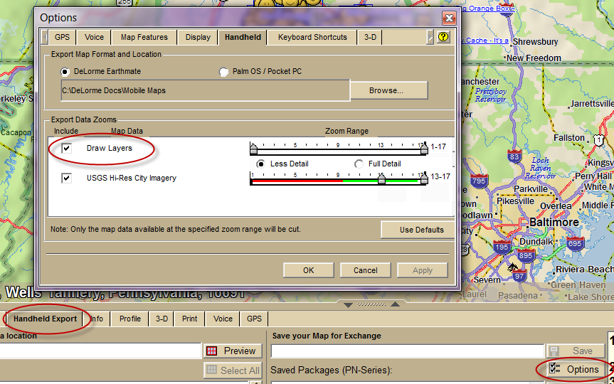
I'll add another heads-up on a problem you may run into trying to include draw layers in map cuts. Due to legacy database issues in Topo8, you might find that you keep getting some sort of message when you try to create your map package that you are including too large an area. If you are cutting a smallish area or a limited number of zoom levels, you might not get the error message. If you get it, I think I can direct you to some discussion on the issue.
What kind of data are you including in those draw layers...POIs?
-
The screenshot is helpful. As I preview my post I see TL beat me to a response, but I'll go ahead and include mine for the picture. I'm always reassured when he seems to be thinking the same track as I. (Edit: eh, I missed a bunch)
It looks to me like things are working as designed...the two waypoint layers show up for exchange, but the draw layers don't. The draw layers must transfer as layers in one or more map packages (All draw layers in a selected area can be included if "Draw layers" is toggled for inclusion under the Options window from the Handheld Export tab when cutting a map package).
-
John, there is what might currently be considered a workaround. By spring it should be directly supported by DeLorme, but currently they released a 2.7 firmware for their XMap product that allows Topo8 to export waypoint gpx files directly to the SD card. (Some details here) You will find this will allow you to carry a lot of benchmark data.
However, you ought to be able to use the cable for direct communication. Aside from trying multiple ports and computers, I'd suggest a phone call to the good folks in Maine on Monday.
One other idea that may not have more than diagnostic value: put the PN-40 into Map Transfer mode (either internal or SD card) to see if it will connect as an external drive. If that doesn't work, I suspect the cable. Check the pins in the connector to make sure they are all protruding, clean the GPS contacts with a pencil eraser.
-
I'm very interested in your take to get a sense of what the current PN-40 Canadian experience can be.
-
Rich has a very nice review of the 500 on his web site.
-
You scared me for minute, Lee...thought you had a personal disaster story to relate.
-
Agree; some of the charging mAh recorded will be lost to heat.
-
Well..."negligible" is in the eye of the beholder. I was happy enough with my PN-20, but there were others who tried it and seemed to regard it as death by slow molasses. Since moving to the PN-40, I would have a hard time going back.
It rarely freezes up, but you'll have slower redraws, slower sort times on large waypoint files, and longer routing calculations. If you are using any map imagery beyond the included vector topos, my memory seems to recall redraws that could take 10 or 20 seconds. There are workarounds for some of these, but the PN-20 is underpowered for the processing demands being placed on it.
I've long been an advocate for the PN-20 as a great value for what it delivers. But with the PN30 and PN40 dipping below $200, I advise going up the next notch unless you are both patient of temper and modest in your GPS needs...partly because of performance but also because of the firmware limitation that TL pointed out.
There's this, too: as long as you buy from an authorized vendor, DeLorme will accept returns up to 30 days. So you can try it out and if you decide it's too slow, you can bail on it.
-
Speed, the 2K limit (I think that's what I recall, too), and the inability to use the Navionics lakes & marine charts.
I note that the Delorme site says the PN-20 is out of stock, too. Somehow I think they'd pull it down if they weren't going to continue to sell it.
-
...and whatever repair is effected, a screen protector will help, uh, protect your screen from future dings. The Zagg screens are highly regarded around here. I'm not certain they work ok on the Dakota, but they do fine on my iPod Touch.
-
It has one draw back in my opinion and that is the inability to load POI's on the SD card. I travel extensively and use route as well as specific area, the problem I have is the need to always be unloading and reloading POI's during my trips.
Have you seen this news?
-
That sounds like an unusual enough symptom that it might be time to say goodbye. Still, it might be worthwhile checking in with the Yahoo Exporist Users group to garner a few opinions there.
Delorme pn-40 connecting issue
in GPS technology and devices
Posted
A couple of things to check: one of the prongs in the cable connector may not be extended; make sure all are poking out of the housing.
Also the contacts on the GPS can get slightly corroded. Freshing them up with a polish from a pencil eraser helps ensure good connectivity (at that juncture, anyway).