

flipflopnick
-
Posts
199 -
Joined
-
Last visited
Everything posted by flipflopnick
-
Waymarking is sufficiently old nowadays that there are multiple Waymarks that can be linked together to form a bigger understanding of a topic. A lone Waymark has part of the story. Whereas several Waymarks would convey more. A bit like Bookmark lists over at GeoCaching.com Is there a way of listing multiple Waymarks by different authors, on the same topic? eg Waymarks about the Pennine Way, a long distance path; Waymarks along a rail line about the history of that line or features on route. As new Waymarks are posted, the list owner could search for new additions as well as the authors asking for their new postings to be added. Self Guided Walks and Trails and Waytours do not do it, or do they? Or is this one for the Lackeys to add to the site?
-
Caches in British Telecom phone boxes
flipflopnick replied to Graculus's topic in United Kingdom and Ireland
There are currently 68 It's Good to Talk caches in Scotland. Nearly all on or near telephone exchanges or kiosks. Better get moving and find them as CNDs before they are archived. Or are BT different in Scotland? -
Geocaching Organisations in the U.K. and Ireland
flipflopnick replied to mandarin's topic in United Kingdom and Ireland
Cumbrian Cachers on Facebook -
OOps! Forgot to disable script in Chrome Extensions once Tampermonkey was installed locally, and on another Chrome profile linked computer. Now only one version of script running. Maps have returned.
-
Photo Competition - October 2012
flipflopnick replied to hobgoblinkiteflier's topic in United Kingdom and Ireland
Visited Arnside Knott EC with TIGG on International Earthcache day for that very reason to find an EC and enter the comp. Found in current month amazing. Doubly splendiferous. Anyway here is the image on the summit. Found without supplementary oxygen. The trig pillar is just behind here in scrubby trees. This is more photogenic. Taken by TIGG on my camera. Lads in background were filming leaping over seat and pretend kicks. Hmm? -
Photo competition - September 2012
flipflopnick replied to Langy's topic in United Kingdom and Ireland
Over a period of several days, persistence paid off. Eventually found High Newton - View Spectacular GC3WQZK View log taken this month at final GZ. Clouds after rain -
Have a good one, as you will have departed by now. A multi day Lake District Tour with caches along the way. Fred Whitton Bike Tour Challenge
-
All batteries self dischage. NiCad are worse. Alkaline next. Lithium have long shelf life. NiMh rechargeable have good shelf life when charged. But the clear winners by a country mile are Sanyo Eneloop. Eneloop are sold ready charged as they have massive shelf life due to lowest self discharge rate. In terms of capacity, use 2000 mAh or greater where possible. Yet to see AAA above 800 mAh. If using a smartphone, turn off screen to save power and carry spare battery. Be aware only NiMh and Lithium batteries will work effectively in low temperatures. (Below 5C?) So every time you take GPSr out in freezing temperatures it will turn off unless using Lithium or NiMh batteries. Bought one charger for all from Unipal. Charges everything. Camera, smartphone, AA AAA batteries. Mains or car. Sorted. Always have right charger. One in car, one at home.
-
So that explains the appearance of caches on Hadrians Wall by NT ranger with zero visible experience. Also Broomlee Lough Two new caches appeared near Sizergh Castle estate. Also NT controlled land, and put out by a suspected NT ranger also with zero visible experience. Boom Boom Trail and Sizergh Fell Looking forward to cache appearing at Tarn Hows. NT Honey pot.
-
The Fred Whitton Bike Tour
flipflopnick replied to flipflopnick's topic in United Kingdom and Ireland
Sorry never did the Tour. Got distracted with minor stuff. Nick -
The Fred Whitton Bike Tour
flipflopnick replied to flipflopnick's topic in United Kingdom and Ireland
The Fred Whitton Bike Tour Challenge cache has been published today. GC2GMC6 Please use this thread to discuss queries about this Challenge Cache. MBFace asked what if you owned a cache on the BOOKMARK list? It would be unfair to have to log your own GC as your find count would increase. It would appear the site will let you log a find if you are already the owner. And log a previous find many times. Therefore it would be impracticable to log your own cache as a FIND as your find count will increase. Perhaps state in your final log which caches you own. Although the CO would have enough gumption to realize who the owner is. You may have Adopted many caches after finding them, hence finding your own caches. This thread has been hijacked to discuss this Challenge cache and a link put on the cache page. Leaving cache page for logs. In mean time work out which ones still to find. Happy hunting -
Yes saw geocachetrails which seams to be 100 miles or over. As most cachers are not ultra runners I presume that site is for automotive power trails. I am asking lackeys about using own power by walking or cycling. Bookmark lists do not do it. Linking caches in a sequence by foot, and probably not same owner.
-
One for the lackeys. How many active Waymarkers are there posting new WMs? Anyone know?
-
One for the lackeys. There used to be www.geohikes.co.uk which listed walking or MTB routes, which had geocaches along the way. No car routes. Walking routes which passed caches. Has Groundspeak any plans of doing anything like that?
-
GPSr Jamming notification
flipflopnick replied to flipflopnick's topic in United Kingdom and Ireland
The nearest caches to below coords are http://www.geocachin...&submit8=Search over 7 km away. Wonder whether searching will be affected. Sat nav will probably be affected. I wonder whether cars will be allowed along the road. NOTIFICATION OF A GPS JAMMING EXERCISE SENNYBRIDGE TRAINING AREA, WALES, DURING THE PERIOD 24 SEPTEMBER – 5 OCTOBER 2012 Details of Low Power Jamming. Dates: Between 24-28 September and 1-5 October 2012 inclusive. Times: 0900 -1700 BST. Location of MULTIPLE jammers: Land based within 5km of N52° 00.881' W003° 38.518' (SN873365 – Dixie's Corner). Frequencies: 24 MHz bands centred around 1176.45 MHz (GPS L5), 1227.60MHz (GPS L2) and 1575.42MHz (GPS L1). Total Power: Up to 10 Watts EIRP. Whenever possible the transmissions will be at lower powers. Details of Higher Power Jamming. Dates: Maximum of two week-days each week between24-28 September and 1-5 October 2012. Exact days to be notified inJamming Warning Message circulated at least 7 days in advance of thefirst jamming. Times: Between 1000-1200, and 1400-1600 BST. Location of MULTIPLE jammers: Land based within 5km of N52° 00.881' W003° 38.518' (SN873365 – Dixie's Corner). Frequencies: 24 MHz bands centred around 1176.45 MHz (L5), 1227.60MHz (L2) and 1575.42MHz (L1). Total Power: Up to 100 Watts EIRP. The jamming will not affect GPS users up to aheight of 25 metres AMSL around the UK coastline. Whenever possible thetransmissions will be at lower powers. It is stressed that, as inprevious exercises, Safety of Life operations will at all times takeprecedence over exercise activities. Ofcom stakeholders should contact InfoGPS.Notices@ofcom.org.uk -
After visiting an abandoned canal tunnel for the first time after it had been on my to-do list since I started Waymarking (several years). I find there is no Category suitable for it. Finding this thread here is my two penneth. Needs to be abandoned. ie no longer used for purpose originally built for. This excludes all under passes and road and rail tunnels and makes getting necessary info safe. If tunnel is in use for original purpose it is not for this Category. Coords are either or both entrances. No cross posting. If Waymark is in another category, duplicate not needed here. eg Abandoned Train Tunnels and others you might be able to squeeze in. Name could be "Tunnels - Abandoned" "Posting in this Category is not meant to be easy." to misquote a TV chef :-) Create the group and I will support it. Lets get this show on the road.
-
GPSr Jamming notification
flipflopnick replied to flipflopnick's topic in United Kingdom and Ireland
NOTIFICATION OF GPS JAMMING EXERCISES SALISBURY PLAIN, WILTSHIRE, July 2012 Dates: Between the 2nd of July and the 11th of July 2012 (Weekdays only). Times: 0700 - 2000 GMT. Location of MULTIPLE jammers: Land based within 5km of N51° 12', W001° 58.5' Frequency: A 24 MHz band centred around 1575.42MHz (GPS L1). Total Power: Up to 10 Watts EIRP. It is stressed that, as in previous exercises, Safety of Life operations will at all times take precedence over exercise activities. Ofcom stakeholders should contact InfoGPS.Notices@ofcom.org.uk"] InfoGPS.Notices@ofcom.org.uk[/email] -
GPSr Jamming notification
flipflopnick replied to flipflopnick's topic in United Kingdom and Ireland
NOTIFICATION OF GPS JAMMING EXERCISES RAF SPADEADAM, CUMBRIA, SEPTEMBER 2012 Dates: Between the 10th of Sept to the 14th of Sept 2012 inclusive. Times: 0700 -2000 GMT. Location of MULTIPLE jammers: Land based within 5km of N55° 04.000' W002° 34.000'. Frequency: A 24 MHz band centred around 1575.42MHz (GPS L1). Total Power: Up to 10 Watts EIRP. It is stressed that, as in previous exercises, Safety of Life operations will at all times take precedence over exercise activities. Ofcom stakeholders should contact InfoGPS.Notices@ofcom.org.uk"] InfoGPS.Notices@ofcom.org.uk[/email] -
May Photo Competition
flipflopnick replied to NickandAliandEliza's topic in United Kingdom and Ireland
Nettle Hill is south of Crosby Garrett. GC3JCCT GC is near the summit and trig. pillar To get there, could go via Smardale Gill Viaduct and take a photo opportunity at Smardale Bridge. -
Historic landowner has very poor regard for geocaches
flipflopnick replied to geofaf's topic in United Kingdom and Ireland
Respondent is set in their ways. Give up trying to place a cache on HS land. All you can do is educate them as to their intrangience. Once you start a dialogue you could be at it for years. HS are confusing muggles with responsible cachers. Often happens. Part of your argument sorry education could be to point out that cachers rarely carry a spare writing implement let alone a chisel and rock hammer. You have to decide whether to crusade on behalf of caching community or not. HS are not mentioned on GAGB agreements. Could ask GAGB negotiators what they have done. -
NOTIFICATION OF GPS JAMMING EXERCISES SALISBURY PLAIN, WILTSHIRE, 7TH MAY 2012 Dates: Between the 7th of May and the 11th of May 2012 (Inclusive). Times: : 0700 - 2000 GMT. Location of MULTIPLE jammers: Land based within 5km of N51° 12’, W001° 58.5’. Frequency: A 24 MHz band centred around 1575.42MHz (GPS L1) Total Power: Up to 10 Watts EIRP. It is stressed that, as in previous exercises, Safety of Life operations will at all times take precedence over exercise activities. Ofcom stakeholders should contact InfoGPS.Notices@ofcom.org.uk Any future exercises on Salisbury Plain please post here. That way people can subscribe to one thread for their area.
-
Multiple Waymarks in One Location for One Category
flipflopnick replied to WanderingAus's topic in General Waymarking Topics
Multiple Waymarks in same Category at one location shows what can be found there. Getting images is part of the challenge. Multiple Waymarks in different Categories also shows what is there. If original poster Waymarks one item, the other similar items can be logged by subsequent visitors, or posted as new Waymarks if Category managers want them in their collection. Post your Waymark and let managers decide. Waymarking may not be about the numbers, like Geocaching, instead it is quality posting, where possible. Accurate coordinates with crisp images and informative text. Getting a reaction from your approver is gratifying. -
With boots there several things to bear in mind. What suits someone else will not suit you. Recommendations count for nothing if your feet do not like the boots. Find a pair of boots to fit your feet not your wallet. Many people complain of sore toes because boots are too short. Get good advice from a trained boot fitter. I doubt you will find such a person in a chain store. I could be wrong. I have seen boot agents deal with customers. Exemplary. Karrimor is a label only, after going bust, many different people use the name to market a variety of different products. Look for a stiffened midsole, not rigid. This will protect your foot and ankles. Wellies lack this. Waterproof liner is necessary if leather is less than 3mm thick, ie Brasher and all fabric boots. Event and Sympatex are more flexible than GTX. Liner does not breathe, all it does is keep water out. After purchase throw away footbed and replace with Proper footbed eg Sidas or Superfeet. These proper footbeds will turn any footwear into the most enjoyable. Have them in all your footwear. Use them every day. Some makers use an iron bar to stiffen. This idea was used 100 years ago by cobblers. Technology has moved on. Merrell Salomon Adidas SCARPA Brasher all use modern midsole stiffeners. VIBRAM is a sole manufacturer only, to which makers attach an upper. Salomon Brasher SCARPA Hi-tec make their own soles. Can you tell I used to fit boots to people's feet? There is more to write. If you are having nightmares with your boots see ALTBERG in Richmond. They will customise your boots to fit your feet. Failing that find a professional boot fitter. HTH
-
February Photo Competition - Traveller's Tales
flipflopnick replied to The Frosties!'s topic in United Kingdom and Ireland
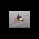
Visitors to Mega2012 will be camping on opposite shore and further north of Fell Foot Park where these pix were taken before dropping off TB The Gardener's Hat in Gummers. -
February Photo Competition - Traveller's Tales
flipflopnick replied to The Frosties!'s topic in United Kingdom and Ireland
I no longer move TBs. Too much hassle. So here is an awesome image from early on in GC career. The cache is Ling Along with Lucky an island in Windermere, the lake's southern basin. In the photo you can see amongst the trees, some mugglets, waving. The TB is Ente. This was my second attempt to get on Ling Holme island. Eventually returned in August, successfully Looking north up Windermere past Ling Holme island. Visitors to Mega 2012 will be able to check this out.