

flipflopnick
-
Posts
199 -
Joined
-
Last visited
Posts posted by flipflopnick
-
-
Have Turned Open Enrollment Off until category has passed peer review. You will have to contact through profile to join group until then. After category is extant, will Turn Open Enrollment On.
-
The above are abstract art as they enlighten the spirit, whereas a folly in usually older, looks like it might be useful but might not be used for the its original purpose.
Modern follies are still being erected. But their naming is subjective in the eye of the beholder.
Perhaps introduce an age restriction, over 50 years old.
Wikipedia summarises
In architecture, a folly is a building constructed primarily for decoration, but either suggesting by its appearance some other purpose, or merely so extravagant that it transcends the normal range of garden ornaments or other class of building to which it belongs. In the original use of the word, these buildings had no other use, but from the 19th to 20th centuries the term was also applied to highly decorative buildings which had secondary practical functions such as housing, sheltering or business use.Ornamental
without purpose
of no use
over 50 years old
Tricky to define, your help much appreciated.
-
another bump with recent approvals added.
-
Group to join. Ever hopeful. Foolish Builders
-
This may have been suggested before but not found, even in read-only old forums.
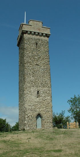
Follies or Folly are whimsical structures built to show the affluence of the owner. They are not a critics opinion of an architect's latest creation.
On this island (UK) we have many follies built during Victorian age but they are not abundant. You still have to find them. Follies appear all around the world.
If you do not understand what is meant by "folly" I will try to explain.
When a land owner has surplus wealth or an idle work force he might create work by erecting a feature which had no useful purpose, purely decorative.
Here is Wikipedia's take on folly.
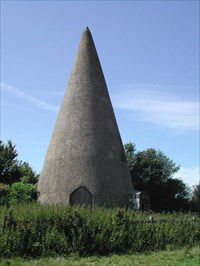
Some follies already posted from around the world. Lacy's Caves Sugarloaf folly
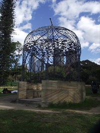
Exclusions would be places where someone famous lived which have folly in the name. Important that no useful purpose be found. If someone lived there, clearly there is a use. Proof of the folly's veracity would have to be shown by the poster. Quote some text, or link to a good explanation elsewhere.
Being called folly is not good enough i.e. an image of the name would not be proof. Prove why the subject is considered a folly to get your posting approved.
All the usual conditions would apply. Accurate coordinates taken with hand help GPS at the the folly, good photographs taken by yourself.
-
Can not say I have seen any public BBQs near here in North England. Not public ones. Open flames are frowned on nowadays and would get a visit from the boys in the red fire appliance. BBQ places are usually on paying camp grounds with a supply of wood for campers. This prevents campers leaving fire pits all over the camp site and defoliating all the nearby green trees and reduces the tent burning which usually follows. see local paper for details.
I have a GC on Peel Island which gets many wild campers. There is nothing combustible below arm stretching height. I am waiting for some enterprising visitor to chop a tree down. Lack of combustible material is our stumbling point here in England.
Other countries may have more charitable BBQ areas.
Put a proposal together and we will vote on it. Got to try.
-
Recent categories added. Surreptitious bump :-)
-
The category is now live. And as usual was not visible in NEWEST categories, but easily found in FULL CATEGORY LIST. It went live 24 hours after peer review finished according to email I received. Group officers did not make category visible. It appeared of its own accord, I think, because I was looking to make category visible. Without success. Unless a lackey was working this weekend?
The results of Peer Review are here.
61 voters 5 anonymous DENIED <-- which shows why Groundspeak put money into GCs. Waymarkers are a prolific minority. Please start another thread on this.
Thanks for your confidence.
The group officers will endeavour to help submitters in the early stages.
Look forward to your postings and finding my own, as English Lake District has many artists over the years.
Alfred Heaton Cooper
Beatrix Potter
Delmar Banner
Jill Aldersley
come easily to mind.
-
Looks like category will go through, unanimously. Better go out and find some paintings to post.
-
Addition to FAQ
Once the group leader has 2 other officers, do not promote anyone else to officer status until your proposal has passed Peer Review.
Once passed and approved, then promote everyone to approve submissions, send group emails and edit the category.
This makes life easier during birth of new Category and ensures longevity once visible.
-
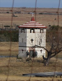
Dovecote is the generic name for a place to breed avian food. Yes originally Dovecotes were a place to grow meat for the table in UK. The rear of the nesting hole was accessible to take the bird and its young, for the table.
Here we also had ponds in the grounds of large houses where fish were caught for the table. Deer Parks also existed where the Lord of the Manor chased deer for the banquets, to feed visiting notaries. Look on a map for a circular area with no roads across it, probably heavily wooded now, called "something Park" and it was almost certainly a chase where meat was stored on the hoof.
This could be an example New Park and Old Park?
I digress.
Dovecotes are no longer used for their original purpose, which was to provide meat at certain times of the year. They come in many forms from free standing to built in to the building. Nowadays they just provide decorative housing for flocks of avian visitors because we nearly all use the supermarket or butcher for local game meat.
The pyramid of holes in Guilder Mill, Hallbeck was a dovecote.

Modern pigeon lofts are not wanted. I doubt whether pigeon fanciers would eat their racing birds.
The dovecote needs to have been a source of food. As I said nowadays we forage in the supermarket.
-
I'm afraid that the number of great ones will be too small for an own category.
Not having many potential Waymarks is good. Getting back to the ideals of Waymarking. (Also less work for group officers :-))
Perhaps state that MUNDANE postings will be rejected.
UK does have evolutions of coastal markers. Cockerham Sands in the Lune Estuary has this light which probably will not fit in Lighthouse group.
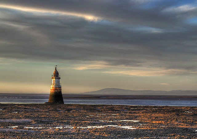
It was never manned nor modernised. Not sure it is even lit now. Back when it was in use, the paraffin lamp was refilled and wick trimmed, daily.
-
Although the Category name could be important to give an instant idea of what is needed, it is not too critical. Memorable is perhaps more pressing.
The name "Framed Views" gets my vote.
Beside the usual two images, people need to know how and when they can access this frame. There might be limitations.
Entrance fee?
Daylight only?
Nearby parking?
The installation may not be permanent. In which case the Waymark might become the only record of what occurred.
-
Thanx for that.
When I searched for "millstones" only Dartmoor Granite came up. Hmm?
Now "Favourited" the category so can not lose it.
-
Am I having a senior moment or was there somewhere to post millstones?
Keep finding millstones in walls, at entrance to houses and just lying on the ground.
Would their previously connected building be suitable for Mills and Gins group?
-
Had many conversations with a police officers. Never two officers together in Cumbria. Two tales come to mind relevant to caching-ish.
Every day pass through Lakeside, near Ulverston, Cumbria. Decided to stop and take photographs for Waymarking purposes.
Photographed Eastvilla, which has a fire insurance crest still on display. <-- Not yet a WM Cat.
Two days later a flourescent jacketed officer (not subtle at all) knocks on my door asking me what I was doing in Lakeside on that Tuesday. Showed him the pix. Turns out someone's soon to be ex-wife thought I had been sent by the soon to be ex-husband to spy on her.
My neighbours are used to police around our area as the youth have got nowt to do but cause trouble. And Cumbria only has two perhaps three officers on duty for the whole county at any one time. The rest are patrolling M6 motorway in blinged fast cars.
Second occasion was at Tongland HEP Station, which is near Kirkcudbright. Getting dark, taking pix of old HEP, built 1934? This time local policeman saw me taking pix of HEP and roadside milestone. Thought I was up to no good, presumably. Called in reinforcements, who appeared within minutes. Both cars then forced me off the road into dead end. Lights flashing. No sirens. Did not want to alert my accomplices, presumably.
After being breathalysed and questioned, running a check. Discovering I had a prior. Told you I am nefarious, they had to let me go. Too dark to continue with pix so went on my way. Causing mayhem presumably as I went.
I realise, police are doing the job we ask them to do. To keep society in order for the rest of us. To make sure the majority behave respectfully to each other.
I have various membership cards in my camera cache bag, which I can show inquisitive muggles. But a SLUG survey card beats them all.
Not been questioned caching yet as have dog and female accomplice fellow cacher with me when out caching. Less suspicious.
Must go to prepare a disguise for next solo outing :-)
-
All the above plus www.openplaques.org and repeat of Waymarking Category. Both of which some of us add to.
Many plaques are on Flickr and other photo location sites.
Some enterprising cachers have already got a Multi involving plaques.
-
In March 2007 I started producing a bundle of text files of all Waymarking Categories. So in the field I could remind myself of what is needed to log or create a new Waymark. GPSr in view was always a bu@@## bain. There is a link back to the original source Waymark category page.
Years later we have smartphones and Internet access in the field and my bundle of up-to-date text files. Still in the same location. Still downloadable by all. Called categories.zip which can be opened and read by all popular operating systems.
May be of use to fellow Waymarkers.
Original thread on read-only old forums.
-
As Bear and Ragged wrote in the first reply Cachers do not click the Nearest Waymarks link on the cache page. Cachers who Waymark have posted caches at their Waymarks. Their cache gets logged, whereas the Waymark does not. So having Waymarks which solve the cache is not a problem. Nearly all cachers are ignorant of Waymarking.
When a local Multi cache is placed nearby I have the answers in place as my Waymarks posted years earlier. Just shows how newbies do not look for spoilers.
BTW I always look for answers to Multis and Virtuals online before venturing out.
We all play this game in different ways. I admire finders who choose a non standard way to achieve their goal.
-
All the above is sound advice. All local cachers rely on visitors to find their hides. BTW mobile signal can be patchy. We all rely on hand held GPSr.
I have created several bookmark lists. The one of interest to any visitor to Lakeland Fells is The Wainwright list. My other Bookmark lists list caches to find along a Long Distance path in Cumbria. Section of LD paths are often walked and listed in guide books.
Using JRI's greasemonkey extension script will show all caches on an OS map. Excellent tool for making your own routes.
When the weather is lousy there are plenty of lower level walks. Any where you stick a pin in the map, there will be caches to find, in Cumbria.
Felltop Weather Forecast to bookmark on your smartphone. http://www.lakedistr...therline.co.uk/ No visiting cachers seam to pay any attention to forecasted gale force horizontal rain when they log the fell top caches wondering why the weather is so atrocious.
Forecast also repeated on Radio Cumbria at 6.30 7.30 8.30 12.30 4.30 5.30 and 6.05
There are no power trails for getting your numbers up, you will have to create your own. AFAIK Saying that I found 33 in 7 days in Cumbria with friends staying for the week whilst I worked 9-5.
THE SMILEYS hides are good for quick finds. Many are cache and dash if you want numbers.
The Borrowdale series in Langstrath is the most (20) to be found in the Lakes as a trail, AFAIK
GAZ has a North Cumbrian series A-Z which may be more.
There are more suggestions for cache walks on Cachewalker forums http://cachewalker.c...om/out-of-area/
For the best views look at the Thomas West series. He wrote the first guide book in 1789, to the Lakes of Cumberland and Westmorland and all his suggested places to stand and view the scene are cache sites. Some are Multis, some stand alone. After visiting all Thomas West sites you will have seen the best views in the Lakes, IMHO.
Be aware that holiday caches do not survive long and rapidly disappear. So if any appear whilst you are here, grab it quick before it vanishes.
If you manage to find 29 caches along the Fred Whitton cycle route, then you can log the Challenge cache in Coniston.
That should keep you going. If you have access to specialist tools like a boat or canoe, this is the Lake District, many caches are only visitable by boat. Many listed on this Bookmark list.
-
-
Can not imagine any caches are affected. But could affect someone. GC2M2N7 appears to be nearest at 4 km away.
NOTIFICATION OF GPS JAMMING EXERCISE STANFORD TRAINING AREA, EAST ANGLIA, March 2013
Dates: Between 18 and 22 March 2013.
Times: 0900 -1700 GMT.
Location of MULTIPLE jammers: Land based within 5km of N52° 29.0’ E000° 45.0’.
Frequency: A 24 MHz band centred around 1575.42MHz (GPS L1).
Total Power: Up to 10 Watts EIRP.
Jammers: Directional jammers radiating CW, BPSK and noise modulation.
It is stressed that, as in previous exercises, Safety of Life operations will at all times take precedence over exercise activities.
Ofcom stakeholders should contact InfoGPS.Notices@ofcom.org.uk
-
The 12/12/12 Sizergh Castle Event for all Souvenir hunters

Good turn out. Nearly filled the cafe with cachers.
-
NOTIFICATION OF GPS JAMMING EXERCISES STANFORD TRAINING AREA, EAST ANGLIA, FEBRUARY 2013
Dates: Between 11 and 15 February 2013.
Times: 0900 -1600 GMT.
Location of MULTIPLE jammers: Land based within 5km of N52$B!k(B 29.0$B!G(B E000$B!k(B 45.0$B!G(B.
Frequency: A 24 MHz band centred around 1575.42MHz (GPS L1).
Total Power: Up to 10 Watts EIRP.
It is stressed that, as in previous exercises, Safety of Life operations will at all times take precedence over exercise activities.
Ofcom stakeholders should contact InfoGPS.Notices@ofcom.org.uk
NOTIFICATION OF GPS JAMMING EXERCISES OFF THE COAST OF EAST ANGLIA, FEBRUARY/MARCH 2013
Dates: 25 to 26 February and 28 February to 1 March 2013.
Times: Intermittently for a 90 minute period in each time slot 0930-1200 GMT and 1400-1630 GMT.
Location of jammers: Sea based omni-directional jammer onboard a vessel sailing within the Experimental Buoys area, as charted, but no further North than 51$B!k(B55$B!G(BN in the area bound by following boundary positions (WGS84):
• 51.916667$B!k(BN 1.453745$B!k(BE (51$B!k(B 55.0$B!G(BN 1$B!k(B27.2$B!G(BE)
• 51.883980$B!k(BN 1.445504$B!k(BE (51$B!k(B 53.0$B!G(BN 1$B!k(B26.7$B!G(BE)
• 51.883607$B!k(BN 1.397795$B!k(BE (51$B!k(B 53.0$B!G(BN 1$B!k(B23.9$B!G(BE)
• 51.916667$B!k(BN 1.421994$B!k(BE (51$B!k(B 55.0$B!G(BN 1$B!k(B25.3$B!G(BE)
Frequency: 24 MHz bands centred around 1575.42MHz.
Total Power: 0.0005 Watts ERP maximum so as not to effect vessels outside the area bounded by the co-ordinates above or aircraft flying above 2500ft.
It is stressed that, as in previous exercises, Safety of Life operations will at all times take precedence over exercise activities.
Ofcom stakeholders should contact InfoGPS.Notices@ofcom.org.uk
NOTIFICATION OF GPS JAMMING EXERCISES RAF SCULTHORPE AIRFIELD, EAST ANGLIA, MARCH 2013
Dates: 25th and 29th March 2013.
Times: 0700 -1700 BST.
Location of SINGLE jammer: Land based within 2km of 52$B!k(B 50$B!l(B 54$B!m(B N, 0$B!k(B 45$B!l(B 38$B!m(B E
Frequency: A 20 MHz band centred around 1575.42MHz (GPS L1).
Power: Up to 0.3 Watts EIRP (300mW).
Jammers: Omni-directional jammers radiating CW.
It is stressed that, Safety of Life operations will at all times take precedence over exercise activities.
Ofcom stakeholders should contact InfoGPS.Notices@ofcom.org.uk
...........................................................................
Update list, use the online forms: http://www.ofcom.org.uk/static/subscribe/select_list.htm.
Not sure if any caches are nearby. Probably not. Can not imagine MOD allow placements near used ordnance.
Category Text Files
in General Waymarking Topics
Posted
Preserved machines added.