

Ernmark
-
Posts
533 -
Joined
-
Last visited
Posts posted by Ernmark
-
-
Thought I'd bump this classic from wayback for those of you that have never run across it before - especially pertaining to edible benchmarks originally created by Zhanna here
I tried it myself a few years ago with some success:

(using powdered sugar instead of cornstarch/baby powder, etc. to 'dust')
Great conversation starter with friends/office workers who are aware of your 'strange' hobby!
-
I just downloaded this app. So far it looks great. I plan to use it a bit in an upcomming trip to your country (I am from Canada).
2 quick points:
To avoid roaming charges I really need a offline mode.
It appears that the map source used or the implamentation in the app is "off" by a bit. Maybe it is just where I am looking (in Manhattan). I am looking at M339 (KU1445). While google maps appears to be off by about 30 feet, the map in the app is on the wrong side of the street...
Note that KU1445 has SCALED coordinates - meaning that they were plotted on a map (although the vertical elevation will be very accurate). Other marks, like triangulation stations, will have ADJUSTED coordinates, meaning that they will be much more accurate (usually better that our consumer-grade GPSr will give). More detailed explanation will be given on Geocaching.com's benchmark FAQ page..
-
I remember reading (on their site, I believe) that the program, at least as marks were concerned ended in 200X. I haven't seen a recovery since...
-
Do you mean 'Triangulation Station'? Very unlikely that a true 'Bench Mark' will have a Lat/Long that accurate.
Are you saying Triangulation Stations have this kind of accuracy, but ordinary adjusted benchmarks don't?
Any horizontally adjusted mark will be very accurate. True 'benchmarks' usually have very accurate vertical information, but were 'scaled' horizontally (i.e., with a ruler on a USGS 7.5' topo map)..
It is amazing how accurate most of these horizontal control marks are considering many go back to the 30s or earlier!
-
Thanks ... I have logged over 120 marks and for almost each one i include accurate gps coordinates and pictures. I have also found a handful marked as not found by someone at the NGS.
...remember that Horizonal Control stations (such as Triangulation Stations) would not need coordinates in the recovery as they have coordinates which are more accurate than our HH2 units. As DaveD mentioned above, marks with scaled horizontal coordinates are where we can help...
-
Although not under the Geocaching umbrella - they can be logged on Geocaching's sister site Waymarking.com under German Trigpoints and German Benchmarks
-
..for some reason they [Power Squadron] stopped doing it in 2005.
..at about that time members of the Power Squadron discontinued submitting reports as an organization. If I remember correctly it was a volunteer project to help with recovery reports as NGS is part of NOAA. A lot of recoveries tended to be near boating areas, but in my area, some members visited marks in the mountains/woods. Like us GEOCAC, some individuals were real serious about it and made detailed recoveries & some looked for the easy finds at the marina.
Like one of the above posts mentioned, I've been all excited to climb a mountain to a mark not officially recovered since 1942, only to find bright pink tape, and some faded green tape, and more faded blue, etc..
-
There is a separate database maintained by NOAA which is more inclusive as not all tidals have made it into the NGS database - here's a link http://tidesandcurrents.noaa.gov - it would be hard to identify this particular one other than by reading the details of the sheets along the Eastern coast of FL (I'm assuming) & looking for a description of a standard USC&GS disk being used (rather than a NOS disk) and stamping of 'TIDAL NO 6 1960'. Hard to believe a disk would roll along the bottom of the seabed to one of the islands ...but stranger things have happened!
-
Thanks for the info everyone!
As an aside, I recently was able to stop by the Point of Beginning (well technically 1112' north of it) on the OH/PA/WV border where the first survey of what was to become the US PLSS system began in 1785 - there's a nice (no-PID) monument there which was featured in Rhonda Rushing's book 'Lasting Impressions'. I was probably more impressed than my Daughters were

-
I have a picture of a PLSS marker located in Haw Creek Falls, Arkansas without the coordinates that go with it:
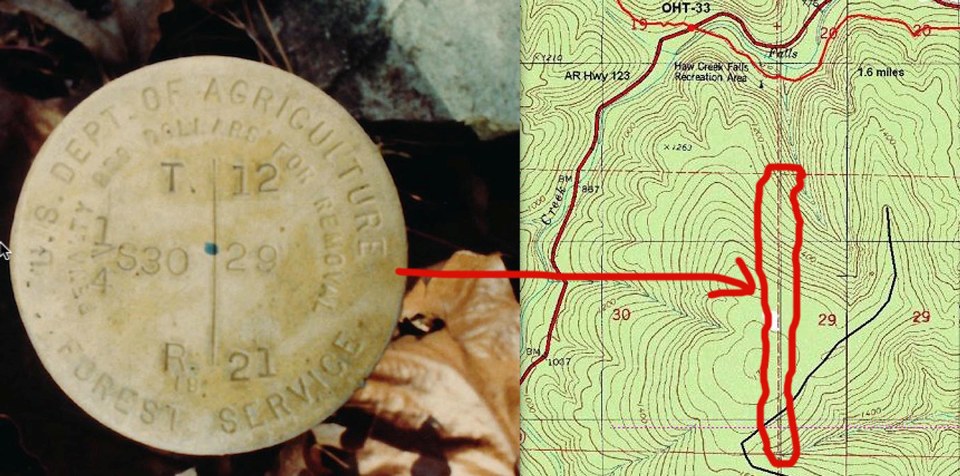
Is it possible to figure out the coordinates where it should be? Closest coordinates given were probably within a few miles, I believe (N 35° 40.584 W 093° 15.324) - Being an Easterner, I'm not really up on the TWP/Ranges grid, although I've read over some of the charts
-
Did you note the link in the line after your trim of the 'sheet:
The Local and Network Accuracy Data Sheet
Program lna_ret Version 2.5 Date December 3, 2013
National Geodetic Survey, Retrieval Date = JULY 17, 2014
JV7206 ********************************************************************
JV7206 ACCURACIES - Complete network and local accuracy information.
JV7206 DESIGNATION - DAVIS
JV7206 PID - JV7206
JV7206
JV7206 Note that Horiz and Ellip values are accuracies at 95% confidence per
JV7206 the FGDC accuracy standards. The values of SD_N, SD_E and SD_h are the
JV7206 standard deviations (one sigma) of the coordinates (NETWORK) or
JV7206 of the difference in the coordinates (LOCAL) in Latitude, Longitude
JV7206 and Ellipsoid Height. The value CorrNE is the correlation
JV7206 coefficient between the latitude and longitude components of either
JV7206 the coordinate (NETWORK) or coordinate difference (LOCAL). The Dist
JV7206 value is the three-dimensional straight-line slope distance, in km,
JV7206 between station JV7206 and the corresponding Local station. Local
JV7206 stations include any other station, regardless of distance, that
JV7206 has been processed simultaneously with the station, in any project.
JV7206
JV7206 Statistical information, in cm, follows. Correlation is unitless.
JV7206
JV7206 Type/PID Horiz Ellip Dist(km) SD_N SD_E SD_h CorrNE
JV7206 -------------------------------------------------------------------
JV7206 NETWORK 1.48 1.84 0.65 0.55 0.94 -0.03851109
JV7206 -------------------------------------------------------------------
JV7206 LOCAL (006 points):
JV7206 JV7254 1.42 1.25 4.23 0.61 0.54 0.64 -0.18168922
JV7206 JV7215 1.48 1.25 5.12 0.64 0.56 0.64 -0.23513394
JV7206 JV7233 1.59 1.57 6.20 0.69 0.60 0.80 -0.08848601
JV7206 JV7242 1.60 2.18 7.47 0.71 0.59 1.11 -0.00521287
JV7206 JV7224 1.48 2.04 7.63 0.67 0.52 1.04 +0.09634709
JV7206 JV7196 1.39 1.80 11.21 0.62 0.50 0.92 +0.05439072
JV7206
JV7206 MEDIAN 1.48 1.69 6.83
JV7206 -------------------------------------------------------------------
...interesting!
-
..I am not sure if she meant that it would be exciting to watch, or just no less awful than the rest of the genre!
I fear it was the latter!
PS - Episode one: 'Search for KW3100 '
-
I've run across that also - I think there was a bug that allowed that to happen with the older waymarks. I seems that the newer waymarks will automatically make the first upload the default, unless the poster selects a different on to make default.
-
Great idea - I've played Buzztime trivia ..we could make it on a weekday (Worldwide Waymarking Take off From Work Day!)
-
..and remember that the gc.com benchmark database pulled from the NGS was imported in 2000 and hasn't been updated since.
-
Could be this one except that the stamping is supposed to be 'ASTRONOMICAL STATION' - it is destroyed, however..
TT1521 ***********************************************************************
TT1521 DESIGNATION - ASTRONOMICAL STATION
TT1521 PID - TT1521
TT1521 STATE/COUNTY- AK/VALDEZ-CORDOVA CENSUS
TT1521 COUNTRY - US
TT1521 USGS QUAD - VALDEZ D-4
TT1521
TT1521 *CURRENT SURVEY CONTROL
TT1521 ______________________________________________________________________
TT1521* NAD 83(1986) POSITION- 61 57 16.08712(N) 145 18 13.67771(W) ADJUSTED
TT1521* NAVD 88 ORTHO HEIGHT - 314.413 (meters) 1031.54 (feet) ADJUSTED
TT1521 ______________________________________________________________________
TT1521 LAPLACE CORR - -0.49 (seconds) DEFLEC12A
TT1521 GEOID HEIGHT - 13.95 (meters) GEOID12A
TT1521 DYNAMIC HEIGHT - 314.837 (meters) 1032.93 (feet) COMP
TT1521 MODELED GRAVITY - 981,929.2 (mgal) NAVD 88
TT1521
TT1521 HORZ ORDER - SECOND
TT1521 VERT ORDER - FIRST CLASS II
TT1521
TT1521.The horizontal coordinates were established by classical geodetic methods
TT1521.and adjusted by the National Geodetic Survey in July 1986.
TT1521.
TT1521.The orthometric height was determined by differential leveling and
TT1521.adjusted by the NATIONAL GEODETIC SURVEY
TT1521.in June 1991.
TT1521
TT1521.The Laplace correction was computed from DEFLEC12A derived deflections.
TT1521
TT1521.The dynamic height is computed by dividing the NAVD 88
TT1521.geopotential number by the normal gravity value computed on the
TT1521.Geodetic Reference System of 1980 (GRS 80) ellipsoid at 45
TT1521.degrees latitude (g = 980.6199 gals.).
TT1521
TT1521.The modeled gravity was interpolated from observed gravity values.
TT1521
TT1521. The following values were computed from the NAD 83(1986) position.
TT1521
TT1521; North East Units Scale Factor Converg.
TT1521;SPC AK 3 - 886,047.927 536,529.966 MT 0.99991634 +0 36 52.0
TT1521;UTM 06 - 6,870,270.322 588,967.693 MT 0.99969696 +1 29 49.6
TT1521
TT1521! - Elev Factor x Scale Factor = Combined Factor
TT1521!SPC AK 3 - 0.99994862 x 0.99991634 = 0.99986496
TT1521!UTM 06 - 0.99994862 x 0.99969696 = 0.99964559
TT1521
TT1521: Primary Azimuth Mark Grid Az
TT1521:SPC AK 3 - KLUTINA 182 08 47.5
TT1521:UTM 06 - KLUTINA 181 15 49.9
TT1521
TT1521|---------------------------------------------------------------------|
TT1521| PID Reference Object Distance Geod. Az |
TT1521| dddmmss.s |
TT1521| TT1523 KLUTINA APPROX. 0.7 KM 1824539.5 |
TT1521|---------------------------------------------------------------------|
TT1521
TT1521 SUPERSEDED SURVEY CONTROL
TT1521
TT1521 NAD 27 - 61 57 17.80100(N) 145 18 05.97600(W) AD( ) 2
TT1521 NGVD 29 (??/??/92) 312.40 (m) 1024.9 (f) COMPUTED 1 2
TT1521
TT1521.Superseded values are not recommended for survey control.
TT1521
TT1521.NGS no longer adjusts projects to the NAD 27 or NGVD 29 datums.
TT1521.See file dsdata.txt to determine how the superseded data were derived.
TT1521
TT1521_U.S. NATIONAL GRID SPATIAL ADDRESS: 6VWP8896770270(NAD 83)
TT1521
TT1521_MARKER: DS = TRIANGULATION STATION DISK
TT1521_SETTING: 36 = SET IN A MASSIVE STRUCTURE
TT1521_SP_SET: PIER
TT1521_STAMPING: ASTRONOMICAL STATION
TT1521_STABILITY: B = PROBABLY HOLD POSITION/ELEVATION WELL
TT1521
TT1521 HISTORY - Date Condition Report By
TT1521 HISTORY - 1911 MONUMENTED CGS
TT1521 HISTORY - 1941 GOOD CGS
TT1521 HISTORY - 1949 GOOD USGS
TT1521 HISTORY - 1949 GOOD USAF
TT1521 HISTORY - 1952 GOOD CGS
TT1521 HISTORY - 1964 GOOD CGS
TT1521 HISTORY - 1964 GOOD CGS
TT1521 HISTORY - 1966 DESTROYED CGS
TT1521
TT1521 STATION DESCRIPTION
TT1521
TT1521'DESCRIBED BY COAST AND GEODETIC SURVEY 1911 (ES)
TT1521'THE STATION IS ABOUT 18 METERS W OF THE TRAIL GOING N AND ABOUT 100
TT1521'METERS N OF THE KLUTINA RIVER.
TT1521'
TT1521'STATION IS MARKED WITH A CONCRETE PIER 14 BY 26 INCHES ON TOP AND
TT1521'PROJECTING 34 INCHES ABOVE GROUND. THE BASE IS 2 FEET IN THE GROUND
TT1521'AND SOMEWHAT LARGER THAN THAT PART OF THE PIER THAT PROJECTS ABOVE
TT1521'THE GROUND. A COPPER DISK TRIANGULATION STATION MARK WITH THE WORDS
TT1521'ASTRONOMICAL STATION STAMPED ABOUT THE TRIANGLE IS SET IN THE
TT1521'TOP OF THE PIER.
TT1521
TT1521 STATION RECOVERY (1941)
TT1521
TT1521'RECOVERY NOTE BY COAST AND GEODETIC SURVEY 1941 (ANS)
TT1521'STATION RECOVERED, MARK FOUND TO BE IN GOOD CONDITION. THE ORIGINAL
TT1521'DESCRIPTION IS NOT ADEQUATE AT PRESENT, THE FOLLOWING IS TO BE USED.
TT1521'THE STATION IS IN THE THIRD JUDICIAL DISTRICT, ABOUT 1/4 MILE W OF
TT1521'THE COPPER CENTER ROAD HOUSE, 65 FEET W OF THE CENTER LINE OF THE
TT1521'RICHARDSON HIGHWAY, ABOUT 75 YARDS N OF A TIN WAREHOUSE OF THE
TT1521'ALASKA ROAD COMMISSION, AND ABOUT 130 YARDS N OF THE KLUTINA RIVER.
TT1521'(THE KLUTINA RIVER HAS CHANGED ITS COURSE SINCE THE ORIGINAL
TT1521'DESCRIPTION WAS WRITTEN.) THE MARK IS AN OLD TYPE TRIANGULATION
TT1521'DISK, INSCRIBED ASTRONOMICAL STATION, SET IN THE TOP OF A CONCRETE
TT1521'POST 14 INCHES WIDE, 26 INCHES LONG AND 34 INCHES HIGH.
TT1521'
TT1521'TO REACH THE STATION FROM THE COPPER CENTER ROAD HOUSE GO W ON GRADED
TT1521'ROAD FOR 1/4 MILE TO THE TIN WAREHOUSE OF THE ALASKA ROAD COMMISSION
TT1521'AND THE STATION.
TT1521'
TT1521'THE ELEVATION OF THE STATION IS ABOUT 1026 FEET.
TT1521'
TT1521'NO OTHER MARKS WERE ESTABLISHED.
TT1521'
TT1521'THIS STATION WAS TIED TO THE TRIANGULATION ARC IN 1941.
TT1521
TT1521 STATION RECOVERY (1949)
TT1521
TT1521'RECOVERY NOTE BY US GEOLOGICAL SURVEY 1949 (RB)
TT1521'STATION FOUND AS DESCRIBED.
TT1521'
TT1521'STATION MARK--A STANDARD NGS DISK SET IN A CONCRETE PIER PROJECTING
TT1521'3.0 FT.
TT1521
TT1521 STATION RECOVERY (1949)
TT1521
TT1521'RECOVERY NOTE BY US AIR FORCE 1949
TT1521'STATION AND REFERENCE MARKS WERE RECOVERED AS DESCRIBED AND IN GOOD
TT1521'CONDITION.
TT1521
TT1521 STATION RECOVERY (1952)
TT1521
TT1521'RECOVERY NOTE BY COAST AND GEODETIC SURVEY 1952 (TCC)
TT1521'THE STATION WAS RECOVERED IN GOOD CONDITION. IT IS LOCATED AT COPPER
TT1521'CENTER, ALONG THE RICHARDSON HIGHWAY, 0.6 MI. S OF STEWARTS STORE,
TT1521'1/4 MI. W OF COPPER CENTER ROAD HOUSE, 0.15 MI. NE OF A STEEL GIRDER
TT1521'BRIDGE OVER KLUTINA RIVER, 271 FT. E OF THE E CORNER OF A TIN
TT1521'WAREHOUSE OF THE ALASKA ROAD COMMISSION, 137.5 FT. N OF AND
TT1521'ACROSS THE HIGHWAY FROM THE N CORNER OF THE HYKE TRANSFER SERVICE
TT1521'GARAGE, 63 FT. NW OF THE CENTERLINE OF THE HIGHWAY, AND ABOUT 2 FT.
TT1521'HIGHER THAN THE HIGHWAY. IT IS MARKED BY A TRIANGULATION-STATION
TT1521'DISK, STAMPED ASTRONOMICAL STATION AND SET IN THE TOP OF A 14-
TT1521'BY 26-IN. CONCRETE PIER PROJECTING 3.0 FT. ABOVE THE GROUND.
TT1521
TT1521 STATION RECOVERY (1964)
TT1521
TT1521'RECOVERY NOTE BY COAST AND GEODETIC SURVEY 1964 (GCR)
TT1521'THE STATION WAS RECOVERED AS DESCRIBED AND FOUND TO BE IN GOOD
TT1521'CONDTION. IT IS 59.0 FEET WEST OF THE CENTER LINE OF THE RICHARDSON
TT1521'HIGHWAY. 55.0 FEET EAST OF THE NORTHEAST CORNER OF THE STANDARD OIL
TT1521'COMPANY BUILDINGS.
TT1521
TT1521 STATION RECOVERY (1964)
TT1521
TT1521'RECOVERY NOTE BY COAST AND GEODETIC SURVEY 1964
TT1521'0.6 MI S FROM COPPER CENTER.
TT1521'0.6 MILE SOUTH ALONG STATE HIGHWAY 4 FROM THE POST OFFICE AT COPPER
TT1521'CENTER, ABOUT 0.15 MILE NORTHEAST OF A STEEL AND CONCRETE BRIDGE OVER
TT1521'THE KLUTINA RIVER, 157 FEET NORTHEAST OF THE SOUTHEAST CORNER OF THE
TT1521'STANDARD OIL COMPANY WAREHOUSE, 137 1/2 FEET NORTH AND ACROSS THE
TT1521'HIGHWAY FROM THE COPPER CENTER GARAGE, 60 FEET NORTHWEST OF THE
TT1521'CENTERLINE OF THE HIGHWAY, AND ABOUT 2 1/2 FEET HIGHER THAN THE
TT1521'HIGHWAY. A DISK SET IN THE TOP OF A 14 BY 26-INCH CONCRETE PIER
TT1521'PROJECTING 2.5 FEET.
TT1521
TT1521 STATION RECOVERY (1966)
TT1521
TT1521'RECOVERY NOTE BY COAST AND GEODETIC SURVEY 1966 (EWR)
TT1521'THIS MARK WAS FOUND BROKEN OFF, AND LYING ON THE GROUND. THE DISK
TT1521'WAS RECLAIMED FROM THE BLOCK OF CEMENT. THERE WAS NO SUBSURFACE, OR
TT1521'REFERENCE MARKS SET FOR THIS STATION. PRESENT CONDITION
TT1521'DESTROYED
-
I post mine in Libraries
-
In the description of a PLSS corner, exactly what does "referenced" mean when a surveyor writes --
"Referenced, removed and replaced 5/8" iron rod with 2" diameter iron pipe 24" long with 3-1/4" brass cap ..."
Does it simply mean that the bearings and distances from the iron rod to pre-existing bearing trees are re-measured?
What if there are discrepancies between previous surveys and the present one?
I believe they also could have held the position with a tripod set over the mark - you might want to post the question over in the Geocaching Benchmarking Forums as there are a number of professional surveyors that read/post there..
-
-
You'll also run into many stations where both the reset and original mark still exist and are in the NGS database..
-
I've seen similar posts & rectangular plates at 2 property corners at a church in PA - only ones I've ever seen until now
-
Back in 2005, BuckBrooke (Buckner Creel) created a page and gave a link (about 3/4 down on page 1 of this thread). It was on a university web site where he was a grad student. After this many years, I'm not surprised if he's moved on and the university cleaned out his account. That username has not logged into this site in the last 2.5 years.
That's right - I remember Buckner Creel - I'll send a message thru GC ..y'never know - the info could still be out there somewhere! Thanks!
-
Just curious - I seem to remember that there was a page somewhere where all of this info was being collected in one place - can't find an active link anymore. Anyone remember?
-
And, please note - many professionals use this service to look up stations. Keep recoveries short, concise, and professional. No "LOL there was a cat on the benchmark.". And do NOT update a station if the last recovery was less than a year ago - unless there is a major change in the condition or 'to get to'.
..not to hijack this thread, but as an 'add on' - I've been noticing a lot of GEOCAC recoveries lately that are incorrect - some examples being a 2007 local agency reset being counted as a found good for a BM set in the 80s, an RM being counted as a lost tri-station, a horizontally adjusted mark which disappeared in the 1920s being found 100 feet away, etc. etc. (the three I mentioned were submitted by people who have found quite a few marks and are submitting them to NGS) A lot of us 'old-timers' remember picking on the US Power Squadron for making some less than stellar recoveries (it was a volunteer project they were involved in if I remember correctly) - I fear that 'GEOCAC' may get the same reputation with professionals if we aren't careful. For people who are just starting as BM hunters, it is best to wait awhile before submitting NGS recoveries & of course read these forums! And ask questions!
Concrete Airway Marker
in Benchmarking
Posted
Awesome article - thanks for resurrecting the thread!