


BRTango
-
Posts
822 -
Joined
-
Last visited
Posts posted by BRTango
-
-
Simple. The cache hider merely slipped through a rift in space and time to hide the cache in 1901.
What I don't understand is why it was only published in 2008.

So much for a 72 hour turn-around!!
-
Sofi and Holmbiorn,
My pre-order was filled and shipped and is showing as having been delivered, but... I have a feeling they may have been "Returned to Sender". Can you please check to see if they were returned to you?
Thank you,
BRTango
Edited to add that I sent you an email through your profile as well
-
If you do use it, you can change the log type to a DNF or Note when on gc.com.
Easy enough to do... just thought it might be a fix that GC.com could implement. Although the bug might be on the garmin side. Don't know enough about field notes to tell.
-
I just got my Oregon 400t for Christmas and can't wait to use it.
I hadn't played with field notes yet, so thought I'd give it a test run.
They work great except for the Unattempted log on the Oregon. When I pull down the field notes, it logs it as a found.
I'm assuming this is due to the fact that "Unattempted" is not a log option on GC.com. Is this something that can be addressed? or should I just not use the "unattempted" feature on the Oregon?
I have never used the Unattempted. Why would you?
To keep track of the ones I wanted to do, but didn't attempt for various reasons. Often when I'm out on a cache run, just to grab a few quick ones, I'll approach a cache from a direction that isn't necessarily a good approach (ie. through a neighborhood, school property, etc...). If I don't feel like like taking the time to find an appropriate approach, I'd like to log it as unattempted.
I'd recommend having the unattempted field note create a log with a "Write a Note" tag. That way I can keep track of what I went after... and can remember to take a different approach next time.
Hopefully that's pretty clear.... it makes sense to me anyway

-
I just got my Oregon 400t for Christmas and can't wait to use it.
I hadn't played with field notes yet, so thought I'd give it a test run.
They work great except for the Unattempted log on the Oregon. When I pull down the field notes, it logs it as a found.
I'm assuming this is due to the fact that "Unattempted" is not a log option on GC.com. Is this something that can be addressed? or should I just not use the "unattempted" feature on the Oregon?
-
Why is it that we can't get Benchmarks logged as finds when they are just as hard, if not harder, to find than a geocache? Seems to me that we should receive credit for finding them too!
They are aren't they? I've logged 3 benchmarks... they show up in my profile as found.
-
There is a GSAK MACRO that will do that for you.
-
The Upload of KML files as Routes is still not working. I've been trying for several hours now. Click the upload button and nothing, no errors, just blank. Ive tried IE and Firefox!!
I need this!! Im going on a trip Weds. Arghhhhhh!!!
I still have the problem if I use a .kml file created by anything other than Google Eart or Mapsource.
If I use one of those, I can upload with no problem. Not sure why nothing else works.
-
Since the site went down, I've been using my sons crayons to color in the county maps.
Now my wife gets really upset when she tries to read her email.

-
I've been thinking for a while that perhaps Groundspeak should start offering the ability to generate stats for people's profile pages :- maybe by introducing a small optional charge.
Lots of people currently use Cachestats, GSAK/Findstatsgen3 or INATN but I know of several people that would like to have stats on their profile but are technologically challenged.
Perhaps it's time for Groundspeak and a 3rd party such as itsnotaboutthenumbers.com to team up to provide a simple integrated solution.
To support the cost of providing this service I could see people paying a small amount. eg: a one-time $5 charge. This would only be for people that wanted the stats. Not a cost that everyone would pay for.
So what do you think? Is there a demand for this service and how much would you be willing to pay for it?
Not a bad idea, but with 3rd party software out there and people who can and will update more frequently than GC.com, I wouldn't be willing to pay anything.
INATN, Findgenstat3 are both very ease to use even for those that are technically challenged. They may have a small learning curve, but once they figure it out, most I've spoken with find it very easy.
-
Is anyone else having a problem uploading .kml files for caches along a route?
I've created a route using google maps and have tried several times to upload it in order to create a PQ. However, after uploading (no errors) no route appears.
Any help would be appreciated.
-
I'll add a great one I did recently, Silent City, located at the Congressional Cemetery in D.C.
I got to see John Phillip Sousa (and family), Elbridge Gerry (the only signer of the Declaration of Independence buried within the District), A lady by the name of Lockwood (the first woman to run for President in 1884 received over 4000 votes), and many many more Revolutionary, Civil War soldiers, Senators, Congressmen, etc.. etc.. etc..
It is one of my favorite caches so far (another favorite was a Revolutionary War cemetery in NH, Till Death Do We Cache)
-
Reading this thread made me think about a cache I did this past Friday.
I found the cache, but did not sign the log book.
The cache was filled with water when I found it, the plastic bag that held the log book had failed and the log book was soaked through and moldy (unfortunately I didn't have anything to replace it with).
I logged both a 'Find' and a 'Needs Maintenance'.
Should I have logged a 'Find' if I didn't sign the log book?
-
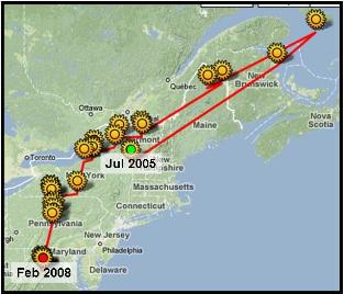
That's a great graphic, BRTango! ... how'd you make it?
StumpWater
Wow, that's a great map! I wonder if somebody could make a GSAK macro that would calculate your centroid for each month.
Thanks, I have no idea how to do a macro... and hadn't considered it, maybe there is one out there or someone who knows how to do macros could put one together. Maybe I'll suggest this at the GSAK macro forums.
Here's what I did (I'm sure there is an easier way):
- I filtered "My Finds" PQ in GSAK for each month (building on each other)
- I ran the findstats macro (month by month) to find each centroid
- I plotted each centroid in Google Earth and drew a path between them
- I exported these to a .kml
- I uploaded the .kml to Google Maps (my maps feature)
- Changed the map to "terrain"
- Did a screen capture
- imported into a photo program
- cropped out the bit that I wanted
Wheww!!! Didn't realize it was that many steps

It was fun and killed time while my son was napping.
- I filtered "My Finds" PQ in GSAK for each month (building on each other)
-
A couple of days ago I got curious as to where my centroid has moved since I started caching. So I started playing with findstats in gsak and came up with the following stats on my centroid:
- Total distance centroid has moved: 1896 miles
- Number of times the centroid has moved: 25
- Average distance change per move: 76 miles
- Number of months caching: 32
- Average distance change per month: 59 miles
- Furthest Distance from Home Coordinates: 572 miles (Sep 2005 Home coords in NH)
- Nearest Distance to Home Coordinates: 57 miles (May 2006 Home coords in NH)
- Northern most centroid position: 43°26'58.44"N 73°26'47.10"W
- Easter most centroid position: (Same as above)
- Southern most centroid position: 38°45'32.40"N 78°30'8.46"W
- Western most centroid position: 38°51'46.68"N 78°34'50.52"W
My original home coordinates were in West Lebanon, NH.
My current home coordinates are in MD, just north of D.C.
My current centroid is amongst some nice rolling hills in western VA (near Rieyville, VA): N 38° 45.851 W 78° 21.443
The nearest cache is: Over the River and Through the Woods
- Total distance centroid has moved: 1896 miles
-
Numerical.
Groundspeak assigns numerical values in sequence to trackable "code sets" based on when they approve/receive designs requests for trackable coins. So, it's sort of chronological too.
Great... thanks!
-
Can anyone tell me what order the icons are listed in on the "Trackables" page on an individuals profile?
-
-
-
Interestingly, Briansnat's post count passed his ID number about 1500 posts ago.Oh wow, I'm number...
(edit after I find my number...)
Number 1,020,154 - and my post count will never catch up...
About a year ago I did a random sampling of days from each year to see how many people signed up and how many had been active in their account within the last 6 months.
While the numbers per day that signed up changed significantly as time went on, the number of accounts active within the previous six months remained about the same. Approximately 26-28% of accounts created were accessed within the six months before I ran the numbers.
-
It sounds like you didn't overwrite the old GPX file with the updated one. I find it's best to delete the previous one completely before downloading a new one from the Add to Queue page.
I second that... I can't count the number of times I've pulled up cachestats and the same numbers pop up.
Delete the old file and re-save the one from your email and try again.
Also, if you aren't aware, there are a few other stats programs:
and if you use GSAK you can use the FindStatGen macro.
-
I once found an ammo can cache in NH in the middle of the winter. It had been left open and had filled with a little more than half-way with water. The water froze.
The ball-point pen was absolutely useless...
but then, so was the pencil, log book, and everything else frozen in that block of ice
;) -
I'm not sure how feasible this is, but what about having a map that shows the spot where all of your trackables are currently located? Not an individual map for one singe trackable detailing where it's been, but one map for all.
Think of it like the Google mpas that show nearby caches. A link from your profile to "map all" would show the world map with pushpins for each trackable.
Do-able?
Anybody else interested in this?
I would like to see it go a step further. I would like to be able to call up a Google map of an area and not see little icons for caches, but little icons for travelers. I could quickly see if there were clusters of caches with TBs or coins.
That already exists for coins... not for travel bugs though:
Home > Trackables > Geocoins Home
Huh! I never knew about that map of coins. Thanks! It only shows coins near my home location, but better than nothing, I guess. Also, some of the "coins" on the map are Jeep Travel Bugs.

I think it'll show Jeep TB's and UFD Travel Bug's. You'll notice on cache pages that they are listed seperately than other TBs'. I think it's they way the build them in the database with the unique icons.
-
I'm not sure how feasible this is, but what about having a map that shows the spot where all of your trackables are currently located? Not an individual map for one singe trackable detailing where it's been, but one map for all.
Think of it like the Google mpas that show nearby caches. A link from your profile to "map all" would show the world map with pushpins for each trackable.
Do-able?
Anybody else interested in this?
I would like to see it go a step further. I would like to be able to call up a Google map of an area and not see little icons for caches, but little icons for travelers. I could quickly see if there were clusters of caches with TBs or coins.
That already exists for coins... not for travel bugs though:
Home > Trackables > Geocoins Home
I really like the idea of having a link to from my account that'll show a map of all of my TB's and coins. I have many that are in Europe and would love a quick and easy view of them. Maybe even a KML for Google Earth.


Problem with GC.com
in Website
Posted
Website just started flying for me.
Slow most of the morning, and the dead... but now, it's screaming!!