

hikergps
-
Posts
472 -
Joined
-
Last visited
Everything posted by hikergps
-
Super Mario Block Game And News Reports
hikergps replied to MagicMeeko's topic in General geocaching topics
Bomb squad getting called=officers on OT=someone is going to pay for it. Maybe they thought they were being set up by this guy! -
Before you panic, check the company website. They have an online manual that should explain it for you. Here is a direct link to the manual. Explorist 200 manual
-
Thanks, I'll try it out. Pretty hard to argue with free.
-
I like it better, too. Changed my map to this one. Very cool! edit: I did like it until I realized it was 800x600, I don't have an image re-sizing tool at the moment but when I get one I'll probably go back to this map. Thanks for the link!
-
On you profile edit page in the "Latest News" section, or whereever you want it paste this exactly as shown: img src= "http://www.world66.com/myworld66/visitedStates/statemap?visited=" At the very front of the above put a "<" and at the very end put a ">" (just the carrot, not the qoute marks). Directly after the visited= put the 2 letter abbreviation for the states you have visited. Mine are WAORIDMT. This will highlight those states in red. Enjoy.
-
Could a reviewer for the North Powder/Anthony Lakes area please contact me, I have a question to ask before placing a cache in this area. Thank you. hikergps
-
I have a Geko 101 that works great, picked it up for about $50 I think. A $100 or less GPSr most likely won't have maps built into it and will just give you straight-line-to-target direction which means that you have to find your own route, but for me that is most of the fun. The Geko 101 has great reception, is smaller than most cell phones, and can go for about 6-8 hours on 2 AAA's in battery save mode. I haven't used a Yellow eTrex but I know the battery life is something like 28 hours on 2 AA's. I tried using NiMH AAA rechargeables in my Geko 1010 but that didn't work well. I have heard that AA rechargeables in eTrex's work fine. Another thing to consider is the Geko 101 is not WAAS enabled and the newer eTrex's are. WAAS helps narrow down your location accuracy to about 3-6 feet. I plan on buying the Yellow soon. BTW-Welcome aboard!
-
I log them all, more for my records than the owners. For me it gives an accurate history of my day caching.
-
Sorry, looks like it not going to be available. I can bring up the paper but can't find the article. It was about a reporter and a U of W friend that borrow a GPS and go looking for a cache called the Sol Duc River Walk. Not being familiar with the GPS or the Olympic Peninsula things did not go too well for them. Just like the first hunt for many of us. They didn't find the cache but ended up getting soaked, muddy and nowhere close to finding the right coordinates. The title of the article was "Geocaching: Reward is in seeking." How true. "For it is not the treasure itself I seek, but the treasure that is the journey." Wish I could remember where I heard that so I can give proper credit.
-
Don't take the DNF too hard. Some of the time when I have a hard time finding one with my Geko 101, it's me and not the GPSr, the rest of the time I blame ground squirells. Welcome to the madness! hikergps edit for typing faster than I think..
-
I don't see the NW represented there anywhere, how about the great state of WA, birthplace of Geocaching?
-
My apologies to the new forum member who started this thread. Look like it was promising for awhile but alas, like so many others, it has gone to the dogs. Must be spring fever. Next full moon isn't until mid April.
-
My own personal way of doing DNF's is I log every visit. For me it helps me track my history of my caching experiences. I usually put something like "I'll come back and try later" or something to that effect. I haven't run across a muggled cache but I would log this as a DNF as well.
-
Was the can damaged or just wet inside? I have a can that I have to check on once in a while and dry out, dump out the dirt, etc. It happens in mine because of the way people handle the cache, not the container's fault.
-
I get mine at a local farm supply store for less than $5 each, no shipping and I get to see the condition of the seals up front.
-
Not trying to sound dumb but is the mil spec printed on the box? I have a virgin box that hasn't been painted over yet.
-
Thanks. I'll check with the Ranger district that handles this area. If I ever get down to LA I'll have to give yous a shot. Well, I appreciate the help on the pesky posts and questions that I had. Look for a posting in August on my adventures up to the Powder marker. hikergps
-
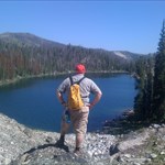
Thanks to all for the help and feedback. I am going to our library today to see if I can find some reference books to pour through to get a little more educated on benchmarks and survey points and the like. I'll also get caught up on the references in the "read me 1st posts". I'm sure that the answers will vary by opinion but from a benchmarker's viewpoint, is it ok to place a cache near this benchmark? By ok I don't mean legal, but is it "geo-ethical" provided I follow all of the other geo-guidelines? This area that I am going into is really amazing and I would like to draw others to see it. Here is a pic of a view from a nearby cache-The Lakes that is alot closer to my starting point than to the station disk, looking back down on the lakes. It is a decieving picture because it really doesn't show the elevation changes involved in getting up there on foot. The large lake in the center, Anthony Lake, is my starting point. It is at 7131 ft. The 2 lakes in the immediate forground, Hoffer Lakes, are at 7472 ft. The view from this peak is at 8522 ft. The peak where the station is is at 8896 ft and 4 miles straight-line ESE from the cache. I am actually not going to hike a route that takes me to this point, but plan on doing it as a seperate day hike that will take me to this peak and 2 more to the NE, that you can't see in the picture. My route for the survey station will start at the large lake in the center, Anthony Lake, by the smaller lake to the right-Lilypad Lake, then past another lake out of frame called Black Lake. This is where the trail stops and the bushwacking begins. From Black Lake I will go up and over a saddle between 2 peaks. Then down into a shallow valley, up and over another saddle, down into Dutch Flat, then up Twin Mountain to the survey station. Straight-line distance is 4 1/2 miles from lake to peak. I figure the route I picked will be 10-12 miles depending on foilage and rocks, with lots of up and down. I figure an easy 2 days there and back, with time to stop and sample the trout at Black Lake on the way back down to my starting point. The bushwacking won't be that bad because alot of it is in scattered trees at higher elevations defined by large granite formations. Thanks again for your responses. hikergps
-
GSAK and Cachemate. Forgot to add BMGPX used for converting benchmark info from the NGS to a GPX file for GSAK. Also use a UTM converted attached to Cachemate.
-
Garmin Geko 101. I'm thinking about an upgrade to an eTrex Yellow.
-
Only plowing 25% of your field.
-
I'll definately get pics of the area for all to enjoy! When going to look for a disk with reference marks, you should always either click on "view original datasheet" or preferable look up the PID (QC0881) on the NGS PID lookup page. On these NGS datasheets, look for the 'box score' which is a box made of ASCII characters. If there is a box score, it should show the direction and distance to each reference mark. Now, with this QC0881, there is a bit of a problem. The description says the direction from the main disk to the reference disk is 119 degrees 56 minutes, while the box score says 299 degrees 56 minutes! So the reference mark disk is eiter 120 degrees or 300 degrees, the opposite directions. Some of these old descriptions used a crazy system of South being zero degrees, so I would lean toward using the 300 degrees direction, but the description clearly said NW, so it's a mystery for you to solve. A bit of caution on using these azimuths - they are True North, not Magnetic North. Your area probably has a bit of declination, so I'd suggest using the NOAA Declination Site to check on this, and make adjustments as necessary. You, being a hiker, probably already know this. Makes my head spin a little looking at the PID. I'll have to do some studying on them. Also, the Quad I have shows 18.5 degrees of declination in 1984, I'll have to get current measurements and compare the drift. Be sure to read the entire benchmark FAQ page. You can't log a find on this unless you find the main station, not just the reference mark. Find both if you can! I've been reading up on them. Best FAQ section I've seen on a subject, really easy to navigate through. I'm not going up until late July (see my previous post) so I have lots of time to get a little more educated. Thanks for the help! hikergps
-
I'm pretty excited about it. I'm going to make an attempt the last week of July with my 12 year old son. We will be camping at Anthony Lakes in the Wallowa-Whitman National Forest for 2 weeks at an annual family reunion that my family has. It should be a good 2 days round trip from where we start. Elevation will be lots of up and down. The last time we were there I was the expedition leader to the top of a peak called Gunsight Mountain. From the lake to this peak was only about 2 1/2 miles each way but it's 1200 ft elevation gain to the top, bushwacking and picking a route for the last mile or so. It was a pretty interesting trip, about 20 of us ranging in age from 8 to 60. Took most of the day to get up to the top and back. Back to the question, looking at the Quad map I have for this area it should be at least 7 miles each way with an overall gain of 1800 ft, but lots of up and down in between. We're thinking of placing an ammo can along the way somewhere as well. Anyway: After some searching on this site, and a few others, I think we might be dealing with a little "drift" in the language over time, or maybe it's a regional thing. I believe that in this case, the "bronze tablet" refered to is the same as the later "bronze disk". I don't know if "tablet" in that context might still be a "term of the art" in surveying, or not. Maybe one of our knowledgeable current or former surveyors could comment on that. Either way, I don't imagine you will have too much difficulty finding them once you get there (the station mark and the reference mark). Have a great time! Thanks! I'll save this thread and post how the trip went. Appreciate the help! hiker
-
I am new to hunting benchmarks and found one that is a fairly tough one to get to. It is in an alpine wilderness area and refers to a tablet that references a station. If you would like to see the page itself it is HERE. For convienence I have cut and pasted the description: Documented History (by the NGS) 1/1/1916 by CGS (MONUMENTED) DESCRIBED BY COAST AND GEODETIC SURVEY 1916 (CVH) ABOUT 10 MILES, AIR LINE, N OF W FROM HAINES AND 1-1/2 MILES N OF THE NORTH POWDER RIVER ON THE EASTERNMOST AND HIGHEST OF THE THREE PEAKS ON THE HIGHEST RIDGE N OF THE NORTH POWDER RIVER, ON WHAT IS KNOWN AS NORTH POWDER MOUNTAIN AND ALSO AS THE THREE SISTERS PEAK. THE STATION IS VERY DIFFICULT TO REACH BY PACK ANIMALS. IT IS MARKED BY A BRONZE TABLET IN A BOULDER AS DESCRIBED IN NOTE 5. THE REFERENCE MARK, A BRONZE TABLET IN A BOULDER AS DESCRIBED IN NOTE 12D, WITH THE ARROW POINTING TOWARD THE STATION, IS 4.81 METERS (15.8 FEET) FROM THE STATION IN AZIMUTH 119 DEG 56 MIN. 1/1/1936 by USFS (MONUMENTED) RECOVERY NOTE BY US FOREST SERVICE 1936 ABOUT 10 MILES AIR LINE N OF W FROM HAINES AND 2 MILES N OF NORTH POWDER RIVER, ON THE E AND HIGHEST POINT OF TWIN MOUNTAIN, ELEVATION ABOUT 8920 FEET. THE POINT WAS FORMERLY KNOWN AS NORTH POWDER MOUNTAIN. TO REACH FROM NORTH POWDER GO W ON ANTHONY LAKES ROAD 4.3 MILES, TURN LEFT FOR 0.7 MILE, TURN RIGHT FOR 3.1 MILES, THEN TURN LEFT OFF ANTHONY LAKES ROAD, GO 3.6 MILES, TURN RIGHT OR W ON NARROW ROAD LEADING UP CREEK, GO 2.1 MILES, TAKE LEFT FORK AND FOLLOW ROAD UP NORTH POWDER RIVER 5.7 MILES OR ABOUT 2 MILES BEYOND NATIONAL FOREST BOUNDARY. THIS IS A POOR ROAD. LEAVE CAR AT CREEK AND ASCEND STEEP SLOPE TO N TO HIGHEST POINT, ABOUT 3 HOURS PACK. STATION MARKED BY DISK IN BOULDER (NOTE 5). REFERENCE MARK, DISK IN BOULDER (NOTE 12D), IS 4.81 METERS (15.8 FEET) NW OF STATION IS AZIMUTH 119 DEG 56 MIN. My 1st rookie question is what is a "tablet" and what would one look like? 2nd rookie question: Is a reference mark a disk? Thanks for you patientce with the new guy!
-
Is it magnetic? You might check the front of your fridge.