


Spnoo
-
Posts
50 -
Joined
-
Last visited
Posts posted by Spnoo
-
-
I work on a polo ground, but unfortunately this doesn't particularly help me because the horses I encounter generally have riders, and all we have to do is 'get out of the way as quickly as possible'.
I was once in a situation that sounds identical to yours in which I had to enter a field containing two horses, and had one of them run towards me. What made things worse was that I didn't know where the exit stile was, so ended up walking around three sides of the field when I could have been in and out very quickly.
So to sum up I'd also love some advice on what to do!
-
Looking at the Ascot area of Berkshire, it looks like the photo dates from between September and December 2004, since the track on the racecourse has been stripped but demolition of the old grandstand has not yet started. Also seems to have been taken on a Sunday morning, judging from the large numbers of cars outside churches!
Is anyone aware of the date of the pictures we had before?
-
Have added myself to the website, sounds like it's going to be great!
-
As far as I can tell, the Venture comes with a cable and the yellow and camo do not. Cables for the yellow can be picked up for around £10-15 from that auction site people use, so in effect it's only a £10 price increase if you go for the venture. Whichever you choose though, if your computer does not have a serial port you will need to get a usb adapter in addition.
Spnoo
-
Hi Deryn.
I own the eTrex Camo, which I bought because at the time for some reason it was cheaper than the yellow, despite it having slightly better specifications. There's a comparison table on the garmin website at http://www.garmin.com/outdoor/compare.jsp . As far as I can tell the main advantage that the venture has is the mapping capability, but I know there are plenty of cachers who use the yellow and get by fine. Whichever you decide to get, do make sure you have the appropriate cables for connecting it to your computer so you can transfer waypoints, as loading them in manually will get tedious very quickly!
-
I used to subscribe to ComputerActive magazine that ran an article on Geocaching, and being fond of gadgets this instantly grabbed my interest. I cycle a fair bit so this I thought would add an extra dimension to it. Signed up and discovered there to be a few within walking distance, and immediately set out to try and find my first, sans-GPSr. This first trip was a bit of a failure, so I scraped the funds together and bought myself an eTrex Camo, being cheeper at the time I bought it than the yellow. Soon after this arrived I found my first, a multi, and both me and my family have been hooked since

Unfortunately I've cached less since coming to university, due to a lack of time and transport, but I still get out as much as I can when I'm at home.
-
Being students, we spent today making many of these:
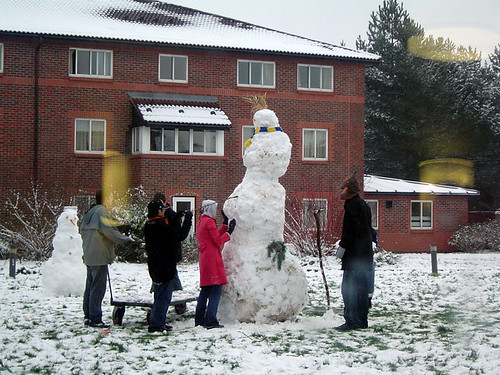
(Those are normal sized people
 )
) -
This popped into my email inbox recently since I've trialed GPSGate before. I'd love to have a play but don't have a PDA or anything I can wander around with. I'd be a bit worried about how much data it's transfering if you used it for a while though. Could get expensive

-
Was wondering myself which PDA to go for once I've saved up a bit (around Easter maybe), and was tending towards one of the Mios since they have built in GPSrs. 10 hours sounds like more than enough for any sort of expedition, where did you get the USB battery pack from? Looks like the P550 is probably what I'll end up buying

-
Mine's arrived today too, and It's headed for Honolulu
-
Much like Bill D and scaw, I've not been out caching in a while, so I'd simply like to go out hunting again! I've also got a TB or two I'd like to get round to releasing, and perhaps even place a cache.
-
Don't blame you, as the site is unsecure.
As is the main geocaching.com site, but I'm sure you sign in to that

I've requested one too, let's hope it arrives while I'm at home over Christmas.
-
I'd be interested in coming along, depending on timing, since I'm now at Warwick University. I agree that a pub sounds better!
-
Can't offer any suggestions about your problem, but Garmin after sales is very good. My etrex wouldn't talk to the computer properly and they replaced it with a new unit a month out of warranty.
-
Just had a look and Traditionals are still at the top for me

-
The Isle of Lundy is very scenic. I've been there once, before discovering caching so I'll certainly be back!
I've returned to Dorney a few times, where the Jubilee flood relief river flows through and the 'What a Relief' (GCKDV9) cache is located. It doesn't sound particularly attractive, being a flood relief channel, but its a nice stretch of water to walk or cycle alongside.
-
The machine that processes them keeps dying apparently. I've been getting one out of 5 for the last two days. Some info on the problem and a workaround is in this thread.
-
Bit hostile around here over the recent months isn't it?

I've an old Nokia 6600 that runs some version of a symbian OS, would be interested to see if I could resurrect it to use for paperless caching.
On a related note, I did spend a long while looking for a simple image viewer for symbian (or my new sony ericsson) that I could use to scroll around map images. Never found a good one though.
-
Try wap.geocaching.com, allows you to look up cache and TB details, and also log finds from your phone. Streamlined for phones too, so doesn't use up much data transfer

-
200 nearest from Ascot, Berks takes me 12.8 miles from home, and 5 have coins in, so 2.5%.
-
I use the Garmin bike mount for the yellow etrex, and find it works really well, seems solid and I've had no problems with batteries disconnecting etc.
-
I've only found 42 so far, so my nearest 10 are still fairly close. Should clear the list over the next few weeks though since I've now finished school.
1. SW 2.9mi - Puzzle cache that I've solved but not been to look for yet.
2. W 3.2mi - Bit of a cycle to get to this one.
3. W 3.2mi - As #2.
4. NW 3.3mi - As #2.
5. W 3.3mi - As #2.
6. SW 3.4mi - In a forest which you have to buy a permit to cycle in, so haven't got round to doing it yet.
7. W 3.5mi - As #2.
8. SW 3.6mi - As #6.
9. NW 3.6mi - As #2.
10. W 3.7mi - As #2.
So it seems the primary reason is laziness at the moment

-
Discovered these earlier today, much nicer than the rather vague maps we had before. Haven't been able to zoom though, but thats probably just the new Opera Beta being silly. Also, like BareClawz I tend to grab an OS map, although I just click the streetmaps link for a 1:50k since I'm a little lazy
-
Any local caches that I do I tend to do by bike, so anything within a cycle of about a 20 mile round trip I'd class as local to me. Quickly running out of these though, so looks like I'll have to start driving at least some of the way soon!
 )
)


new mag!
in United Kingdom and Ireland
Posted
I'm in need of a new project, so I'd be happy to help with any coding or design stuff